Author: Tracy Cozzens

  • Spirent SimHIL tests GNSS/sensor fusion for auto industry

    Spirent SimHIL tests GNSS/sensor fusion for auto industry

    New hardware-in-the-loop application programming interface (API) for GNSS simulators enables greater accuracy, integrity and control for growing sensor fusion testing needs

    Spirent Communications plc has released SimHIL, an integrated hardware-in-the-loop (HIL) testing software API for Spirent GNSS simulators.

    SimHIL brings high-fidelity GNSS signal simulation with low latency to automotive industry HIL testbeds, the company said.

    Image: Spirent
    Image: Spirent

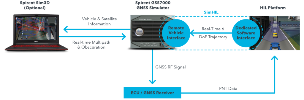
    Spirent’s SimHIL software has been developed to meet the automotive industry’s growing need for realistic positioning, navigation and timing (PNT) testing for sensor fusion. As customers apply increasing pressure on car manufacturers for more advanced driver-assistance system (ADAS) features and advanced infotainment systems, test labs need to be able to combine Wi-Fi, camera, lidar, radar, inertial and GNSS data that power these advanced automotive systems.

    SimHIL helps test engineers bring accurate, controlled and coherent data from GNSS and inertial sensors to their sensor-fusion algorithms within HIL test environments. Facilitating the ultra-low latency, complete control, enhanced realism, and ease of use and setup of Spirent GSS7000 and GSS9000 GNSS simulators, SimHIL is suitable for OEMs and tier-one suppliers developing ADAS, V2X and sensor-fusion engines.

    The new SimHIL API enables:

    • external motion input – real-time direct motion and trajectory data input from simulators
    • sensor fusion – introducing GNSS signals into sensor-fusion engines
    • V2X testing – validation and performance benchmarking of V2X applications
    • infotainment system testing – real-time scenario feedback to system and driver responses
    • vehicle-in-the-loop (VIL) – final production form product testing
    • accurate testing – reliable results supported by ultra-low latency simulation. Criticality of ADAS features, such as lane assist and automatic braking, mean that 3+ metres of uncertainty introduced by higher latency systems is not sufficient.

    “With our SimHIL software and GNSS simulators, test engineers can bring realistic, controlled GNSS simulation to their HIL testing environments – a vital requirement in a world where ADAS features are relying more heavily and critically on accurate positioning,” said Martin Foulger, general manager of Spirent’s PNT business.

    Spirent has worked with leading suppliers to ensure SimHIL is compatible with their HIL platforms, and because of its open API, there’s broad scope for additional custom third-party integrations.

    “When used with our GSS7000, SimHIL latency is less than 40 ms from motion command to RF output and supports all GNSS and SBAS signals,” said Ricardo Verdeguer Moreno, product manager for Connected and Autonomous Vehicles at Spirent. “SimHIL is also compatible with all the options and features available in Spirent’s GNSS simulators, including ionospheric and tropospheric modeling, antenna patterns, date and time settings, and obscuration and multipath effects via Sim3D.”

    Users can easily configure and control both the GNSS scenarios, and signal generation and vehicle motion from within the HIL simulator graphical user interface — saving time and the possibility of error.

    Spirent is also offering three service packages alongside SimHIL to help customers mitigate project risk and reduce the time from delivery to useful deployment.

    For more information about Spirent’s SimHIL integrated testing for Spirent GNSS simulators, visit the SimHIL information page.

  • Woolpert wins Google Cloud LBS Partner of the Year award

    Woolpert wins Google Cloud LBS Partner of the Year award

    Woolpert logo

    Woolpert has received the 2019 Google Cloud Specialization Partner of the Year award for location-based services.

    Woolpert was recognized for the company’s achievements in the Google Cloud ecosystem, helping joint customers deploy and optimize their location-based services, developing an online customer assistance system and cloud information portal, more than doubling its staff to support customer needs and supporting all location-based data efforts with its extended geospatial team.

    The firm, which has been a Google Cloud Partner since 2015, was awarded this honor and the Google Cloud Partner Award for Customer Success in Google Maps Platform in 2018. Woolpert Vice President and Chief Innovation Officer Jon Downey said Woolpert is honored to work with Google Cloud and provide a heightened level of products and services to the teams’ joint customers.

    “We thought this would be a natural partnership, joining the world leader in customer-facing location-based services with one of the first global geospatial mapping firms, but it has far exceeded our expectations,” Downey said. “It has given us the ability to create products and provide support specific to our clients’ location-based needs, which has led to a greater than 98% retention rate and more than 100 additional customers in 2019. We look forward to what this partnership will yield in the future.”

    “We’re proud to recognize Woolpert’s work on behalf of customers,” said Carolee Gearhart, vice president, Worldwide Channel Sales at Google Cloud. “Woolpert has demonstrated strong expertise and results in providing location-based services for customers over the past year, and we look forward to continuing our partnership to help customers succeed.”

  • Regulus Cyber’s GPS protection becomes part of Harman Shield

    Regulus Cyber’s GPS protection becomes part of Harman Shield

    Photo: Regulus
    Photo: Regulus

    Regulus Cyber, creator of what it calls “anti-virus” software to protect GPS navigation and timing across a wide range of applications, is collaborating with Harman, a connected-car company.

    The software-based cybersecurity solution will be part of Harman Shield, the company’s risk-management offering for vehicle manufacturers and mobility companies.

    “We are looking forward to joining forces with Harman, a Tier 1 supplier to the automotive industry, a trusted partner to more than 50 global vehicle manufacturers. Coming together with Harman is a great testament to the necessity of GPS protection measures in our industry,” said Yonatan Zur, CEO of Regulus Cyber.

    “We’re seeing our OEM customers expand into the digital and mobility spaces, offering added-value services to consumers by leveraging connectivity and mobile applications,” said Asaf Atzmon, vice president and general manager, Automotive Cybersecurity at Harman. “Through Harman Shield, we offer full visibility, analytics and risk management capabilities into cyber threats, and Regulus Pyramid GNSS solution complements our offering with another layer of protection against GPS hacking. We’re excited about the possibilities of this new collaboration with Regulus.”

    The Regulus Pyramid GNSS is a software solution that uses machine learning to detect spoofing and defend any GNSS receiver, device or chipset against it — ensuring the security and reliability that are essential to safe and accurate navigation. GPS spoofing attacks are becoming more common and are often difficult to detect and protect against.

    Pyramid GNSS uses a combination of patented algorithms, developed over years of spoofing experiments to protect against attacks at the firmware, operating system, or application level. This deal is further proof of the market demand for resilient navigation and positioning at a time when GPS hacking is a growing concern.

  • Orolia to host industry discussion on PNT Executive Order

    Orolia to host industry discussion on PNT Executive Order

    GPS jamming and spoofing threats are national priorities

    Logo: OroliaOrolia will host an industry discussion online at 2 p.m. ET on May 7 on the Positioning, Navigation and Timing (PNT) Executive Order. Register here for the informal PNT Coffee Talk.

    The PNT Coffee Talk event will be held online and is open to those interested in learning more and discussing this national priority from the industry and government perspectives.

    The Executive Order, issued Feb. 12, is a federal initiative to protect critical infrastructure from GPS/GNSS jamming and spoofing threats, and other disruptions to critical PNT services. These threats can deny access to, or compromise, essential PNT data that critical infrastructure needs to operate.

    This initiative, titled “Executive Order on Strengthening National Resilience through Responsible Use of Positioning, Navigation and Timing Services,” includes the following critical infrastructure: defense, homeland security, transportation, power grids, communications/mobile, precision agriculture, weather forecasting and emergency response.

    Key actions include assessing jamming, spoofing and other PNT disruption risks across these critical infrastructure programs, developing customized PNT profiles to address risks, and deploying Resilient PNT technology to increase resilience.

    Survey seeks feedback. Orolia asks those interested to share questions and comments and let the company know what you’d like to discuss during this PNT Coffee Talk event through an anonymous survey.


  • Schriever stays operational despite COVID-19

    Schriever stays operational despite COVID-19

    News from the U.S. Air Force, 50th Space Wing

    Despite the worldwide COVID-19 response, the 50th Space Wing at Schriever Air Force Base continues to execute its critical operations, while ensuring the proper steps are taken to maintain airmen’s health and well-being.

    As of March 20, there are no confirmed cases of COVID-19 at the base. The 50th Space Wing commander, Col. James E. Smith, has enacted multiple safety measures — social distancing, minimum manning and temperature checks at restricted area portals — to protect Airmen and the base’s critical operations.

    No pandemic in space

    Airman 1st Class Brice Brewington, 4th Space Operations Squadron, is an extremely high-frequency satellite systems operator.

    “It’s critical we continue the mission during trying times,” Brewington said. “Although there is a pandemic here on Earth, there’s no pandemic in space and our adversaries aren’t going to stop trying to gain superiority from us any time soon. We need to stay mission-ready rain, sleet, snow, hail and even during a pandemic to complete our mission at the most elite level possible.”

    To minimize transmission, 4th SOPS Airmen use cleaning wipes and sanitation spray to clean their workstations. Additionally, accountability is taken daily to make certain the squadron’s airmen are feeling healthy and well.

    “I know the service I help provide is critical for [service members] down range,” Brewington said. “I take my job very seriously. Lives depend on it, and we can’t let a pandemic slow down our operations.”

    2 SOPS at their stations

    The 2nd Space Operations Squadron is one of the United States Space Force’s premier units. 2 SOPS operates the GPS mission, providing a global utility to Earth’s population for free.

    “No matter what, we need to ensure this mission continues so the American people and the world know they can depend on us to be the gold standard in precision, navigation and timing,” said Lt. Col Stephen Toth, 2nd SOPS commander.

    Some of the services that use GPS to operate are ambulances, hospitals, police departments and fire departments.

    “It would make a global pandemic that much worse if we were to go down,” Toth said. “It could prevent a lot of the day-to-day things we rely on from happening, it could be catastrophic.”

    According to a study conducted by U.S. Department of Transportation on the economic impact of GPS, a 30 day outage could range from a 2.7 to 5.5 billion dollar economic loss. Additionally, GPS supports 14 of 16 essential industries in the U.S.

    “We’ll remain reliable no matter what the condition the world is in,” Toth said. “Whether it be a pandemic, hurricane, tornado or any other type of crisis, we have plans and training for whatever threat we may face so the mission doesn’t stop.”

    Unlike other jobs across the Department of Defense, those directly conducting operations can’t telework. They need to be in a sensitive compartmented information facility or restricted area in a secured area to perform the mission. Airmen can access specific terminals and networks only accessible on the operations floor.

    “The American people can count on space and they can count on our military to continue to provide the level of capability that’s expected no matter what’s going on in the world,” Toth said. “In times of crisis, people shouldn’t have to question whether we’ll be here or not, because we will and the mission won’t stop.”

    Senior Master Sgt. Michael Welch, 50th Contracting Squadron superintendent, distributes sanitizer to an Airman at the 50th Logistics Readiness Flight warehouse at Schriever Air Force Base, Colorado, April 2, 2020. The 50th CONS secured sanitizing supplies to units across the base to prevent Airmen from contracting COVID-19. (Photo: U.S. Air Force / Airman 1st Class Jonathan Whitely)
    Senior Master Sgt. Michael Welch, 50th Contracting Squadron superintendent, distributes sanitizer to an Airman at the 50th Logistics Readiness Flight warehouse at Schriever Air Force Base, Colorado, April 2, 2020. The 50th CONS secured sanitizing supplies to units across the base to prevent Airmen from contracting COVID-19. (Photo: U.S. Air Force / Airman 1st Class Jonathan Whitely)

    Rapid response and decontamination

    The 50th Space Wing stood up the Rapid Response Decontamination Detail in response to COVID-19 and hosted a training session March 26 in the wing headquarters building. The training highlighted the importance of having a crew on standby to keep the mission essential operations centers clean and functioning.

    “It’s a 24/7 team trained and equipped for rapid response to support operations inside the restricted area,” said Capt. James Selix, 3rd Space Experimentation Squadron weapons officer and R2D2 officer in charge.
    For operations crews to request R2D2 services, a squadron commander must call the team and they have 15-30 minutes to respond and initiate the cleaning operation.

    “We’re expecting airmen do the preventative portion of their cleaning,” Selix said. “We’re not there to do it for them. We are activated when there are folks showing symptoms of COVID-19 or have positive tests.”
    The crew has a priority system should they need to deconflict requests.

    “We want to be rapid to support operations,” Selix said. “[Airmen] are continuing their missions 24/7 and if their crews are doing deep cleanings, that’s pulling them away from doing supports, contacting satellites or protecting the restricted area.”

    The detail will be operating in eight-hour shifts to ensure their 24/7 availability. They will be on standby to provide terminal cleanings and supplies to squadrons as needed.

    “This is a new enemy,” Selix said. “This is a new fight for all of us. We’re developing teams that make sense in the fight against COVID-19, it takes all of us building the road as we walk it.”

    The crew has hydrogen-peroxide, disinfectant wipes, protective gear and cleaning sprays and solutions to ensure the operation floors are sanitized and operational.

  • Fortem Technologies ships DroneHunter F700 C-AUS

    Fortem Technologies ships DroneHunter F700 C-AUS

    DroneHunter F700. (Photo: Fortem Technologies)
    DroneHunter F700. (Photo: Fortem Technologies)

    DroneHunter F700 is a radar-based autonomous interceptor drone for tracking and stopping dangerous drones

    Fortem Technologies Inc. is now shipping its artificial intelligence (AI)-enabled F700 DroneHunter. The F700 is a safe, effective deterrent against a rising number of careless and criminal drones, the company said.

    The F700 has a flexible undercarriage that offers interchangeable counter measures for single, multiple or swarm-based threats. Its new lightweight carbon-fiber frame enables greater athleticism and speed.

    The F700 can carry multiple types of anti-drone countermeasures and deploy them in real-time, based on the dynamic threat detected miles beyond the protected area. The undercarriage features pogo pins and payload snaps integrated with AI-enabled firing and flight software.

    Underside of the DroneHunter F700. (Photo: Fortem Technologies)Photo:
    Underside of the DroneHunter F700. (Photo: Fortem Technologies)Photo:

    The F700 offers significant payload capacity to handle situations over civilians where zero collateral damage is required. AI decisions are now made in real-time to select the appropriate effectors for the detected threat. Complex algorithms for flying in urban areas are now supported. Heavier drones are tethered or parachuted with controlled descent into predetermined safe zones.

    The F700 is equipped with ground- and airborne-networked radar and corresponding optics, giving users total situational awareness and autonomous precision. F700 is custom designed and manufactured in the United States.

    “We have advanced the DroneHunter F700 so that it can deliver any ordinance necessary to stop drones and to protect stadiums, refineries, campuses and entire metro regions,” said Fortem Technologies CEO, Timothy Bean.

    Fortem is developing several DroneHunter mitigation types, including directed energy.

  • GPS constellation changes with addition of second GPS III satellite

    GPS constellation changes with addition of second GPS III satellite

    The U.S. Coast Guard has issued a Notice Advisory to Navstar Users (NANU) detailing the changes to the constellation now that the second GPS III satellite has joined.

    The U.S. Space Force Second Space Operations Squadron (2 SOPS) issued an Initial Use (USABINIT) NANU for the second of the new generation of GPS-III satellites, designated SVN-75/PRN-18.

    SVN-75 was launched on Aug. 22, 2019, and — having successfully undergone rigorous operational testing on orbit — has taken its place in the active GPS constellation with the slot and plane designation of D6.

    Constellation changes

    Artist's rendering of GPS IIF satellite. (Image:  U.S. Air Force )
    Artist’s rendering of GPS IIF satellite. (Image: U.S. Air Force )

    SVN-45/PRN-21 is being re-phased from D3 to D2F replacing SVN46. Upon its arrival, SVN-46/PRN-11 will then be moved to residual status in Launch, Anomaly and Disposal Operations (LADO).

    SVN-60/PRN-23 was decommissioned on March 2, eight and a half years beyond its expected service life. SVN-60 was the 12th GPS-IIR to go in to orbit, and began service on July 9, 2004.

    Learn more at the NAVCEN home page.

  • IQD launches a new GNSS-disciplined crystal oscillator

    IQD launches a new GNSS-disciplined crystal oscillator

    Photo: IQD
    Photo: IQD

    IQD has launched a new series of GNSS-disciplined oven controlled crystal oscillators (OCXOs), the IQCM-112 series.

    The new design incorporates an internal GNSS receiver with a 1PPS output, which is compatible with an external GPS, GLONASS, BeiDou and Galileo source. It is housed in a 14-pin 60-millimeter-square package.

    When coupled to an external aerial antenna via the incorporated SMA connector, in the event of the loss of the GNSS signal the highly specified 10-MHz OCXO will switch-in with a holdover capability of 1.5 µSeconds for a 24-hour period, thereby maintaining lock until restoration of the reference signal.

    The standard operating temperature range of the module is -20° to 75° C but is also available with a -40° to 85° C operating temperature range. Other holdover specifications can be considered upon request.

    The required power supply is 5V with a standard HCMOS output. Current consumption is 2A maximum during warm-up with this reducing to 1A once the steady-state condition is reached.

    The design incorporates an internal adaptive algorithm that enables the module to “learn” the parameters of the GNSS signal after a period of three days of lock, so that the holdover function can start in the event of signal failure.

    A built-in internal alarm indicates lock failure and subsequent restoration of signal. The unit incorporates a serial connection for more detailed interrogation of the device’s performance.

    The IQCM-112 series is intended for a range of applications including land-based telecommunications systems and marine-based navigation systems.

    The IQCM-112 forms part of a range of highly specified modules and Oven Controlled Crystal Oscillators available from IQD.

  • Aceinna ships high-precision navigation module for autonomous vehicles

    Aceinna ships high-precision navigation module for autonomous vehicles

    The Aceinna OPENRTK330L integrates a triple-band RTK/GNSS receiver and a triple-redundant inertial sensor to enhance the safety of autonomous systems.

    Photo: Aceinna
    Photo: Aceinna

    Aceinna is now shipping its OPENRTK330L, a cost-effective module designed for developers creating mission-critical guidance and navigation systems for autonomous vehicles, including robots, drones, industrial, construction and agricultural machinery.

    Aceinna designed the OPENRTK330L to replace expensive and bulky precision RTK/INS systems used in today’s autonomous systems.

    The OPENRTK precise positioning engine optimizes satellite tracking and high RTK fixes rates while integrating seamlessly with Aceinna’s open-source Open Navigation Platform.

    In January 2020, the Aceinna test vehicle drove from the Bay Area to the CES 2020 event in Las Vegas using the new module. Along the way, Aceinna engineers tracked its path and accuracy.

    ACEINNA’s OPENRTK330L includes a triple-band RTK/GNSS receiver coupled with redundant inertial sensor arrays to provide centimeter-level accuracy, enhanced reliability and superior performance during GNSS outages. It integrates a precise 1.5-degree/hour inertial measurement unit (IMU) to offer 10 to 30 seconds of high accuracy localization during full GNSS denial.

    The OPENRTK330L’s embedded Ethernet interface allows easy and direct connection to GNSS correction networks around the world. OPENRTK330L’s CAN bus interface allows simple integration into existing vehicle architectures.

    The multi-band GNSS receiver can monitor all global constellations (GPS, GLONASS, BeiDou, Galileo, QZSS, NAVIC, SBAS) and simultaneously track up to 80 channels. The module has RF and baseband support for the L1, L2 and L5 GPS bands and their international constellation signal equivalents.

    By integrating a triple-redundant IMU array, the OPENRTK330L is able to recognize and utilize only valid sensor data, ensuring high-accuracy protection limits and certifiability under ISO26262 standards. ACEINNA’s triple redundant 6-Axis IMU array uses a total of 9 accelerometer and 9 rate gyro channels.

    The OPENRTK330L is supported by ACEINNA’s Open Navigation Platform, allowing custom-embedded application development on top of the positioning engine and dead-reckoning algorithms.

    OPENRTK330L hardware also includes Ethernet, UART, SPI and CAN interfaces for versatile integration into a host system. Additional specifications include operating temperature range of -40C to +85C, and qualification to standard automotive shock and vibration levels.

  • InnerSpace location platform supports public safety, COVID-19 response

    InnerSpace location platform supports public safety, COVID-19 response

    Photo: Kachura Oleg / iStock / Getty Images Plus / Getty Images
    Photo: Kachura Oleg /iStock / Getty Images Plus/ Getty Images

    Indoor location platform provides municipalities with emergency response and public safety solutions on existing Wi-Fi networks

    InnerSpace, a Toronto-based company, is offering its Wi-Fi-based indoor location intelligence platform to support all levels of government. The platform analyzes patterns and movement in public spaces using existing Wi-Fi networks.

    The platform is suitable for understanding the movement of people inside public spaces and can support emergency response strategies, social distancing programs and help smart cities implement effective security and public safety measures.

    “In response to the global COVID-19 pandemic, we have accelerated the delivery of our public safety solution inFORCE,” said James Wu, CEO, InnerSpace. “Our platform processes RSSI [received signal strength indication] data in real time and returns the industry’s most accurate location data available today. By using public Wi-Fi access points, municipalities have a way to quickly roll out new solutions at city-wide scale.”

    InnerSpace inFORCE was selected in a competitive process by the U.S. Department of Homeland Security, for its ability to use Wi-Fi to locate citizens and track emergency responders in an active shooter scenario.

    The same platform can be used in a wide variety of emergency situations such as the current COVID-19 pandemic. In addition to the company’s tracking capabilities, it’s analytics dashboard gives public safety offices an unprecedented view into how people leverage public spaces.

    “In times of emergency, it is reasonable to prioritize safety and public health to minimize the loss of human life,” said Cerys Goodall, president and COO, InnerSpace. “By providing municipalities with a system that can deliver line-of-sight into how people move in public spaces, we can inform response strategies, improve rescue efforts, and create an infrastructure to support better outcomes.”

    InnerSpace inFORCE ingests RSSI data and returns accurate anonymous indoor locations. The information can be connected directly into emergency response communications systems, building management and security systems, or analyzed by InnerSpace to identify critical patterns and trends in people’s movements.

  • Gladiator Technologies introduces small, high-performance GNSS/INS

    Gladiator Technologies introduces small, high-performance GNSS/INS

    Gladiator Technologies’ low-noise inertial sensor and systems technology coupled with Velox high-speed processing are now integrated with a 72-channel GNSS receiver to provide compact GNSS/inertial navigation systems (INS) for accurate position, velocity and attitude.

    Landmark 60 GNSS/INS. (Photo: Gladiator Technologies)
    Landmark 60 GNSS/INS. (Photo: Gladiator Technologies)

    The feature set was carefully selected to suit several positioning, navigation and timing (PNT) applications including flight control, navigation and stabilization for imaging, platforms and antennas.

    The high-performance LandMark 60 INS/GPS and compact LandMark 005 INS/GPS both feature advanced sensor-fusion technology, combining GNSS position data with Gladiator Technologies’ low-noise, high output inertial sensors as well as barometric pressure and magnetometers.

    Both products feature Gladiator Technologies’ proprietary Velox  processing technology and extended Kalman filter (EKF), enabling precision position information during short-term GPS outages.

    Velox  Technology combined with the new EKF enable the LandMark  INS/GPS products to have accuracy of less than 2 nautical miles per hour during short-term GPS outages.

    Landmark 005 GNSS/INS. (Photo: Gladiator Technologies)
    Landmark 005 GNSS/INS. (Photo: Gladiator Technologies)

    The LandMark 60 INS/GPS is the top performing unit with +/- 0.3° heading accuracy and pitch/roll angle measurements of 0.1°. It is also available with an option for a real-time kinematic (RTK) GPS receiver.

    The small and robust LandMark 005 INS/GPS is less than 35 square centimeters and is suitable for space-constrained applications that require a high standard of INS/GPS performance.

    “Our low-noise sensor inputs to the EKF are enhanced by an adaptive estimation algorithm,” said Lee Dunbar, chief software architect. “This, along with extended precision for the nonlinear solution integrator, maximizes the accuracy of position, velocity and attitude. Customer configurable EKF parameters are present to allow optimization for their applications.”

    “Leveraging our inertial capability into a complete INS/GPS package was a natural progression for our product line,” said Eric Yates, Gladiator Technologies’ new business development manager. “With the LandMark 005 INS/GPS and LandMark 60 INS/GPS we’re offering an exceptional MEMS-based INS/GPS that fits in the palm of your hand.”

    A development kit is available for set-up, configuration and data collection.

  • Esri to provide mapping resources to WHO Member States

    Esri to provide mapping resources to WHO Member States

    Advanced geospatial technology offered to global communities during COVID-19 crisisPhoto:

    Global mapping company Esri will provide a COVID-19 Response Package for the World Health Organization (WHO) Ministries of Health and Global Outbreak Alert and Response Network (GOARN) partners.

    The package will enable these organizations to have access to Esri’s geospatial platform and tools that can be used for reporting and analysis of cases and deaths, public health and response activities at the national level, in addition to managing testing sites, community activities and impact, and much more at the local level.

    “The intent of our partnership with WHO is about providing technology and capacity building to all the national and local Ministries of Health,” said Jack Dangermond, Esri founder and president. “Having integrated geospatial data and analytics is important to a comprehensive and dynamic response to the rapidly changing situation related to COVID-19. This is particularly true in low resource countries.”

    This contribution to the global COVID-19 response will support the digital transformation of global health information systems through mapping and analytics technology. Esri’s geospatial software helps organizations understand complex and vast amounts of data by placing it in a geographic context with sophisticated analysis capabilities such as artificial intelligence (AI).

    “While our company has always supported the efforts of governments and NGO’s when facing crises, the COVID-19 pandemic is different and requires a rapid and global response,” said Dangermond. “Our work with WHO is about helping MoHs around the world in equipping and assisting communities with our technology. We strongly believe these efforts will help combat its spread.”

    Ministry of Health or GOARN partners can request their COVID-19 Response Package here.

    Software access for students

    Esri is also providing free access to its ArcGIS platform and learning resources through its Learn.ArcGIS.com website to support college and university students who no longer have access to campus computer labs during the COVID-19 outbreak.

    Students will receive access to ArcGIS Online and over 20 apps including ArcGIS Pro, along with a library of lessons to continue their learning and complete courses. Access is available globally to students ages 18 and over.