The European Space Agency (ESA) has funded Ampyx Power, developer of a next-generation wind energy technology, and Omnisense, developer of locating and tracking solutions, to develop a robust fail-safe navigation system.
The positioning solution will be used for automated take-off and landing of Ampyx Power’s wind-energy aircraft when applied offshore or over rugged terrain. The technology will be enabling as well for other drones in critical applications.
Ampyx Power develops airborne wind energy systems (AWES) using autonomous tethered aircraft as a means for generating electricity on the ground. The launch and land deck is smaller than the wing span of the aircraft. High accuracy, availability and integrity of the relative positioning between aircraft and platform is required during the final horizontal approach to ensure safe landing of the aircraft in the case of GNSS outage.
The funding will cover the integration into the navigation solution of a local positioning system that seeks to provide 10 centimeters of relative positioning accuracy with 100-Hz update rate and an operating range up to 1 kilometers. Ultra-wideband positioning techniques will be used to make this happen.
“The project allows us to integrate a backup local positioning system into the existing high-end navigation solution,” said Michiel Kruijff, head of technology at Ampyx Power. “This novel navigation technology will ensure that our aircraft can overfly the platform with great accuracy, even in case of GNSS failure. This solution is particularly relevant for use cases in rugged terrain or offshore where other affordable means of relative positioning would be too costly or would offer insufficient performance or availability. We seek such a high level of system robustness both for commercial reasons and for safety reasons, in line with our certification approach with the European Aviation Safety Agency (EASA).”
“We are pleased to offer our innovative local positioning system (LPS) to this project,” said Andy Thurman, CEO at Omnisense. “The closely time-synchronized fusion of ultrawideband (UWB) signals exchanged between landing deck and aircraft mounted Omnisense beacons, will allow highly accurate range measurements to be provided to the drone autopilot, enabling continuous operation in the safety critical landing phase. The enhanced capabilities which arise as a result of this project will enable Omnisense to extend the market reach for our flexible LPS offering from the industrial asset and animal tracking markets in which we currently operate, to more dynamic applications such as GNSS denied drone control, autonomous vehicles in smart cities and sports performance analysis.”
Klau Geomatics has launched MakeItAccurate, a global GNSS data correction and processing service.
MakeItAccurate takes data from any GNSS receiver on drone or survey equipment and makes it accurate. Users can now achieve centimeter (cm)-level accuracy without the need for base stations, real-time kinematic (RTK) links, data from Continuously Operating Reference Station (CORS) or other external inputs.
MakeItAccurate requires only the raw GNSS data from a drone to produce a highly precise trajectory and turn the traditional autonomous 3-5m GPS accuracy to 3-5 cm anywhere in the world.
In many parts of the United States, Europe, Japan, Australia and New Zealand, absolute accuracy of 2-3 cm XYZ will be achieved. In these areas, the KlauPPK processing engine applies sophisticated hybrid PPK/PPP algorithms, merging global PPP clock and orbit corrections with many distant CORS stations to achieve this high absolute accuracy.
The service enables enterprise drone operations to achieve high accuracy across their entire global operations with one repeatable workflow.
Sectors such as insurance, telecommunications and utilities can scale their operations without additional survey expertise and site-specific data constraints. The same process works for multiple operators on thousands of sites enabling consistent, high accuracy every time, the company said.
MakeItAccurate supports data from all GNSS manufacturers. Native support for DJI M 210v2 RTK or Phantom 4 RTK drones returns precise camera positions with centimeter-level accuracy. Other drones using external PPK GNSS products also can achieve highly accurate kinematic trajectories and camera coordinates.
A MakeItAccurate application programming interface (API) is available to push raw GNSS data to the processing engine and return highly accurate coordinates, with full reporting on the accuracy achieved for the entire trajectory or each camera event. GNSS hardware manufacturers can offer a custom service to add value to their products. Software developers offering artificial intelligence technology, photogrammetry processing or other outcomes that benefit from high accuracy can use the MakeItAccurate API.
Social distancing and stay-at-home orders are affecting every sector of our economy. How are companies in our industry rising to this enormous challenge? What are they doing to keep their staffs, customers, and communities safe and to help slow down the spread of the pandemic? What are they learning in the process?
We asked our marketing partners, Editorial Advisory Board members and “Innovation” Editor Richard Langley the questions below so that we could share their collective wisdom with you, our readers. The advertisers’ responses appear in alphabetical order by company, followed by the responses by EAB members.
We will continue to publish these responses here as we receive them; we will also publish a selection of them in the May print issue of GPS World.
Professor, Department of Geodesy and Geomatics Engineering,
University of New Brunswick, Fredericton, Canada
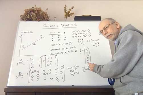
“Innovation” Editor and UNB Professor Richard Langley lectures to his students online. (Screenshot: Richard Langley/UNB)
On March 13, the president of the University of New Brunswick announced that as of the following day due to the Coronavirus-19 outbreak in the province of New Brunswick, all in-person classes would be suspended for the remained of the school term, and that starting March 23, classes would resume using alternative methods to support delivery outside the classroom. Faculty members like me had a week to find other ways to deliver our courses to the students. Some of us turned to pre-recorded video presentations and some, like me, to live class sessions using online video conferencing tools like Zoom and Microsoft Teams. I tried both but ended up using Teams on the advice of the university administration.
This term I was teaching GGE 3111: Introduction to Adjustment Calculus. Basically, it’s an introductory course on the mathematical technique of least-squares analysis. Least squares, where one seeks to find the minimum of the sum of the squares of the estimated errors in measurements, is a fundamental technique for analyzing data in many application areas in the sciences and engineering disciplines, including the processing of GNSS data. It was pioneered back in the early 1800s by Gauss, the great German mathematician and father of modern geodesy.
Incidentally, Kalman filtering also widely used for processing GNSS data, is essentially a recursive approach to the least-squares problem. The example I am doing on the board (see screenshot) is how to fit a straight line to data pairs x and y where both the x and y values contain random measurement errors. I have always taught GGE 3111 using the blackboard or, since lecturing from the dining room of my house by video link, a whiteboard.
I recorded my home-delivered lectures and provided these to the students through the Desire to Learn platform that UNB uses for teaching. Not all of the students could attend the live lectures as some had returned home to provinces with several hour time differences from New Brunswick making it inconvenient to attend a morning lecture. Others no longer had a good Internet connection to view real-time video.
The recordings also provided a useful resource to the students for reviewing the course material. When we eventually return to normality, I might continue to record my lectures. They could even form the basis of an online version of my course available to UNB students and non-students alike.
CAST Navigation has overcome many obstacles and challenges to be able to provide our customers with the products and services that are valuable to them during this difficult period. The company has instituted a set of strict policies and procedures that allow us to manage our facility hours and employee “distancing” practices.
We have also enabled employees to work remotely if necessary and we continue to work very closely with our vendor supply chain to minimize delays and impacts to our schedule. These policies and procedures, along with a very focused and devoted staff, have allowed us to continue to provide the superior quality products and services on which our customers rely.
Eos Positioning Systems’ employees are able to work remotely in most cases. In fact, prior to the pandemic, a number of full-time employees worked remotely across Canada, the United States, and the Asia/Pacific region. Now, we’ve transitioned all employees to remote working and transitioned the tasks of individuals whose routine work was directly affected by the virus. We’ve also added a weekly all-staff video Zoom meeting to address everything from company questions to individual wellbeing.
We were already grateful for our ecosystem of staff, partners, and customers, but everyone has shown their positive colors even more in response to this pandemic. Everyone remains responsive across platforms and time zones. The uptick in social media engagements of our customers and partners has been particularly great to see.
In addition, we’ve heard from some customers that they are using our GNSS receivers more during this time. Because our receivers are easy to use for the novice, office workers who would typically not do fieldwork are being trained on field work, which can be a naturally socially distanced, one-person job.
As expected, many of the events we enjoy sponsoring have been postponed or canceled. We’re working with event coordinators and our own team to ensure that when events start up again, we are prepared to go back to business as usual. We are really, truly looking forward to seeing our customers, partners, and colleagues in person again!
At GeoNumerics, we are all OK, including our families. As we are an R&D-intensive company focused on algorithms, software, and consultancy, we are lucky these days. Furthermore, some of our employees —women with young children — were already teleworking most of the time. Therefore, it was easy to extend this to the rest of the company.
Since mid-March, everyone is at his/her place teleworking. This enables us to:
keep the company running
keep our employees busy like in “normal” days
protect our customers by meeting deadlines
protect the economy by not stopping the business
on a case-by-case basis, help our providers/partners who had to stop their business.
Internally, we share a “good morning” short communication via WhatsApp and a daily 20 minute “virtual coffee break” after lunch via Skype.
Miguel Amor, Chief Marketing Officer, Autonomy & Positioning Division
Editorial Advisory Board Member
Miguel Armor
COVID-19 is affecting everyone on a global scale, which means that we all must work together to limit the spread of the virus and protect the people at risk. At Hexagon, our priority is keeping our employees and customers safe, and we are following all guidelines and recommendations set up at national, regional and local levels to do so.
Through all of this, we recognize that our employees and our customers are relying on Hexagon more than ever. Rest assured that we are taking all necessary steps to protect our employees and to minimize risk to the supply of our products and our services to our customers.
At Hexagon | NovAtel, we believe our size, reach, and position not only provide great opportunities but also carry great responsibilities. We understand that the GNSS community in general is relying on NovAtel more than ever and we are taking all the necessary steps to support the community and our customers.
Just like many of you, we at JAVAD GNSS are quickly and actively adapting to the changing times caused by the global COVID-19 pandemic. We recognize that JAVAD plays an important role in many of your operations and in supporting the critical missions of our customers. To that end, we are following best practices to curtail the spread of this virus and protect the well-being of our employees and partners, while ensuring we meet the commitments to you that you have come to expect.
Our primary message today is JAVAD GNSS is Open for Business! Our support team is here and ready to assist you as it always has. Please do not hesitate to contact us.
While there was a short pause in March when news broke in the U.S. about COVID, much of this now seems to be subsiding. At the same time, the value for instantly accessible aerial maps is more obvious than it ever was. As teams work from home and push to keep projects on track, the need for remote access to aerial photography remains strong at a time when travel and remote site inspection is lower than it ordinarily would be. Judging from very recent activity (all April 2020), there’s high interest from city government, engineering, construction, solar/energy and land development.
For Orolia, this crisis has highlighted the importance of the word “resilient.” As a leader in resilient positioning, navigation and timing (PNT) and as an essential business, we need a resilient organization that can keep delivering the critical solutions that our customers need. We can’t let our customers down because they support defense and critical infrastructure programs worldwide. Now more than ever, we recognize the essential nature of what we provide, and we must keep supporting our customers, even in times like this.
Orolia plays an essential role in the Defense Industrial Base (DIB) in the Critical Infrastructure Sector, as defined in the Department of Homeland Security (DHS) Memorandum on Identification of Essential Critical Infrastructure Workers During COVID-19 Response and the DHS Guidance on the Essential Critical Infrastructure Workforce: Ensuring Community and National Resilience in COVID-19 Response.
Many global companies need to continue operating as normally as possible to provide much needed capabilities in order to help governments, members of the armed forces and critical infrastructure to stay operational.
Our Supply Chain/Sourcing team conducts regular risk assessments to ensure that Orolia partners can continue to provide uninterrupted service by securing materials and products. Our service, support, business development. and engineering teams also remain ready to respond to requests.
We use Skype extensively, to keep in touch with our customers and partners but also for internal conference calls and meetings. There isn’t really a substitute for face-to-face meetings, but Skype is as close as you can get. In terms of communicating with our partners we have very much moved into the digital space. We have instead held webinars using WebEx which have been very well received. We have more planned so watch this space!
We have learned that we can work very well under pressure! With COVID-19 postponing some of our favorite shows we didn’t want to sit back and do nothing. We had to act very quickly and look at other ways of communicating our message. Not only have we as a business been agile enough to do this, despite working remotely, our channel partners have really taken on board what we’ve been trying to achieve and helped us exceed our goals.
Don’t use COVID-19 as an excuse to rest on your laurels. Take it as an opportunity to do some of the things that you otherwise wouldn’t have done.
To collaborate remotely, a safe distance from each other, we use video messaging (MS Teams) with team(s) daily, as well as Confluence (engineering documentation) and Jira (task management) for remote collaboration.
Much of our team is able to continue efficient operations while working remotely. Collaborating with our customers has always been a service we offer – which, we believe, leads to better product performance and reliability. This pandemic has pushed the majority of the country/world into remote working. While we aren’t able to be in person with customers, accessible remote tools and collaboration help us continue to provide hands-on customer service, without actually using our hands.
Parker LORD designs and produces MicroStrain inertial sensors that are used in robots that aid in delivery, mapping, and surveillance activities. Our inertial measurement units (IMU) and inertial navigation systems (INS) are designed to allow quick time-to-market development. We offer IMU/INS integration with our recently updated Robot Operating System (ROS) drivers for ease of use. By using our sensors, we have reduced development time while also offering top performance and competitive pricing. There are different levels of inertial sensors based on the performances available depending on the application being used.
As the need for measurement and navigation solutions increase with the demand for delivery, safety and automated robotic monitoring, our new 3DMGQ7-GNSS/INS dual antenna RTK-enabled INS provides next level performance with integrated custom IMU, dual integrated RTK-capable multi-constellation GNSS receivers, integrated barometric pressure sensor, and magnetometer. Beyond the integrated sensors the GQ7 offers hardware support for wheel odometry and API support for external velocity sensor measurements. This sensor has been designed for use in markets such as beyond visual line of sight (BVLOS) unmanned aerial vehicles (UAV), unmanned vehicle navigation, legged robots, and autonomous vehicles. It’s an all-in-one system solution (GNSS-INS + RTK + SensorCloud RTK).
Get ready for the robot revolution. There was momentum in that direction before, in areas such as delivery, recon and mapping. Acceptance of these technologies will only increase now and in the future.
Racelogic, the company behind LabSat GNSS simulators, is based in Buckingham, UK. Like many companies, we are adjusting to new ways of working and remote collaboration. With the majority of our 100 staff now working from home, I have few concerns about their ability to adapt and am confident that the outcome will be one of success. However, I am also aware that the paths taken over the coming weeks or months are unlikely to be without a few bumps in the road.
I am hearing reports from all corners of Racelogic about how staff are dealing with these unprecedented circumstances. For example, Katie Harland, our LabSat Support and Applications Technician, is continuing to support our customers from home. However, without a rooftop antenna on her building she has had to be a little inventive about how she gains a live satellite feed to record test scenarios. Her solution was to mount an antenna on a ground plate devised from the lid of a biscuit tin and set it on her garden wall. An effective solution, but one that is not straight forward when you are 5’2” and the garden wall is 7’ tall.
I am also noticing changes to what a “normal” day at work now looks like. With so many staff working remotely I find myself walking through the office and instead of checking on project progress I am rebooting computers, connecting equipment, accessing server files, and generally servicing those who are working remotely. I think it is easy to fall into the trap of obsessing about perfecting remote working. I don’t think you can go too far wrong if you focus on the things you can do, even if you need a ladder to get there.
During these challenging times, Septentrio continues to be operational and to serve its customers. We have taken measures to ensure health and safety within the company. Most of my colleagues and I are working from home, while manufacturing has been divided into two shifts to guarantee continuity and provide the safest possible working conditions. Although international travel is suspended for the moment, we continue to have regular meetings via phone or web with our partners, customers and prospective clients.
This virus is forcing us to rethink the way we work and interact. As we adjust to the new situation, we are finding ways to continue working with as little disruption as possible, leveraging the efficient communication networks and remote-control solutions available to us today. Along the way we might even discover new more efficient and environmentally friendly ways of working.
In addition to ensuring employee safety, Septentrio is also dedicated to help fight the virus by providing reliable high-accuracy positioning solutions to technologies that are making a difference. For example, aerial drones have been used by police in Europe to announce new government regulations in public places and to scope out large areas for public gatherings. To ensure public safety it is vital that the sensors aboard these aerial drones, such as their positioning receivers, are robust and reliable even in challenging conditions.
Other delivery drones such as Zipline and Wing are expected to ramp up speed with the increase of automation required to fight the coronavirus. In the European Union and the United States regulations around drone use are stricter than in China and thus the full potential of drones is not yet realized to its maximum.
Since our inception, a few of our employees have worked from home due to traffic issues, work/home responsibilities, or simply geographical location issues. Over the years, we decided as a company not only that this was working very well, but that everyone who could work from home should be allowed to have the same privileges. In the past two years, we have allowed everyone to work from home, only requiring to come into the company offices those who must be in a lab or for security reasons. Everyone has a laptop computer and remote access to files. We use Zoom, email, and cell phones to communicate with each other and our customers.
When the recommendations from the CDC and the President of the United States were issued to work from home, we were already doing this, so there were no adjustments needed. Those that must work in the lab are practicing social distancing and working on alternate days in some cases.
When we first contacted our customers to attempt visits, we were told that they were not receiving visitors and that it was going to take a few days or weeks to get everyone outfitted with laptops and other technology to continue working from home. We were a bit surprised to learn that others were going through this as we were not having any of these issues.
This crisis has taught us that being prepared and trusting our team to work independently pays off when we really need it. Everyone is being a little extra patient, kind, and understanding. We are seeing this general compassion outside of the office as well and we hope that this has a lasting effect on the world.
Jackie Ferreira, Director of Corporate Communications
Jackie Ferreira, Topcon
We are fortunate in that our team is well-versed in online collaboration software, including teleconferencing and online digital asset management systems. We are leveraging tools such as those to keep productive in this crisis.
We are working very well together via safe distancing practices. Our employees around the world are staying active with ongoing conference calls across multiple time zones. Our primary concern is the health and safety of everyone we interact with and we continue to be impressed with how all involved have responded.
Topcon operates with a primary goal of the health and safety of its employees, customers, and suppliers and in accordance with applicable state and local orders, including social distancing requirements. To this end, we provide on-going guidance from the World Health Organization (WHO) and Center for Disease Control (CDC) to our employees to support their health in these critical times.
We encourage compliance with applicable governmental orders concerning their ability to continue to operate, with the understanding of roles within the critical infrastructure supply chain.
We are dedicated to supporting our customers at this critical time and have specific teams working to meet demands to the best of our ability.
Our relationships with our customers and partners are important to us. Topcon strives to work closely together with our partners to protect the industries we serve and accelerate the economic recovery needed in light of the current world crisis. Together we can serve as a beacon of cooperation and commitment to successfully weather these unusual times.
The outbreak of COVID-19 started around the Spring Festival, and strict control measures to stop the spread of the virus were taken even before the holiday ended. Unicore postponed the return-to-job date by one week and encouraged working from home, except for the key R&D and ST engineers, who cannot perform verification, testing, or debugging outside the labs. However, even then strict social distancing measures were guaranteed. As of February 10, Unicore’s return-to-work rate was more than 80%, with nearly 40% of the employees doing it from the office, while now nearly 90% of Unicore’s labor force is back to normal working mode. Thanks to the 4G networks, fast mobile and Web communications, as well as cloud computing technologies, we were able to easily organize video conferencing, online meetings and group messaging.
Our R&D and product delivery were slightly affected by the COVID-19 due to the delays at some supply plants. However, Unicore has a well-run and organized inventory management system, so most of the orders can be fulfilled on time.
Some of Unicore’s clients use drones to perform disinfectant spraying and logistics transportation, which help to ensure an uninterrupted supply of food and goods. Other clients make intelligent and autonomous sweepers that reduce the need for manual labor and keep the workers safely at home. In order to avoid personal injury, infection and transmission in epidemic areas, drones and/or unmanned vehicles with GNSS high-precision positioning technology have been used for cleaning and disinfection, supplies delivery, and aerial photography in engineering construction.
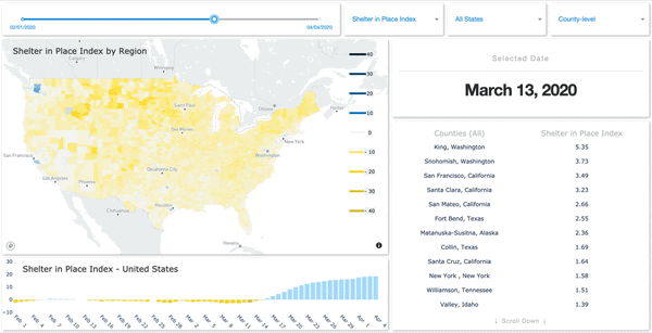
SafeGraph has launched a Shelter in Place Dashboard that enables users to visualize stay-at-home behavior for every county in the United States.
Image: SafeGraph
SafeGraph has also created and released two new datasets:
Weekly foot-traffic patterns
Social Distancing Index
The data is being provided at no cost to non-commercial entities.
“We currently have over 550 researchers, non-profits and government agencies in a Slack group using these new datasets,” said Evan Barry, vice president of marketing, SafeGraph. Academic and industry research articles based on the data are now published on the SafeGraph site.
New series of free webinars for construction, geopositioning and agriculture facilitate learning
Topcon Positioning Group is launching a free webinar program for the construction, geopositioning and agricultural sectors, exploring key topics affecting the industry and providing the latest updates and project management solutions.
The Topcon Talks series, consisting of numerous informative webinars, has been created in response to the ongoing COVID-19 pandemic and aims to provide those working from home with valuable educational resources, while maintaining steady communication with Topcon customers, dealers and the wider industry.
The webinars will focus on a range of topics such as improving productivity using digital construction workflows, overcoming barriers to technology adoption, and more practical how-to sessions for customers and dealers on specific Topcon solutions.
The webinars will be delivered by a range of Topcon experts, with input from several other industry specialists, and cover a multitude of topics including:
Always One Step Ahead – an overview of Topcon’s latest product developments, market focuses and acquisitions
State of the Industry series – looking at the barriers to technology adoption in construction, such as attracting talent and bridging the skills gap
Detailed technical sessions showcasing latest hardware, software and web services to get the most out of Topcon solutions
The content series is live on the site, with new sessions taking place regularly over the coming weeks. All sessions are free to attend, and those wanting to participate will first need to register on the Topcon website.
“Everyday life has changed very quickly, and businesses across the world are having to adapt. At Topcon, we are working tirelessly to help the industry weather this storm. We’re aware that at this time, the majority of people are working from home, and we want to continue to support our customers and colleagues as much as possible,” said Ron Oberlander, vice president of global professional services at Topcon Positioning Group. “That’s why we’ve developed this webinar series — to provide an opportunity for continued professional development so that professionals can remain as productive as possible during this challenging time and be in the best position possible to accelerate the industry’s recovery when we come out the other side.”
The webinars are also recorded and uploaded to the site once complete, so those who are unable to attend the session can access the content in their own time.
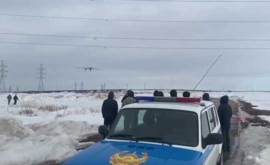
Terra Drone group company KazUAV has helped Nur-Sultan police to use drones to patrol and monitor illegal border movement and slow the spread of coronavirus in Kazakhstan
KazUAV, Kazakhstan drone service provider and a member of Japan-based Terra Drone Corporation, has been working at the frontlines to keep communities safe amid the COVID-19 pandemic outbreak.
Providing direct support to the operational headquarters set up to prevent the spread of coronavirus in Kazakhstan, KazUAV has been helping the Nur-Sultan Police Department to patrol the borders of the locked-down capital city with drones, ensuring “contactless” surveillance and fast-paced operations.
Nur-Sultan is the capital city of Kazakhstan.
The Central Asian nation closed its borders and locked down its main cities, including Nur-Sultan, after confirming the first coronavirus case on March 16. The oil-rich country that borders Russia and China also announced a state of emergency, set to last until April 15, adopting tough measures to combat the pandemic.
Some of the guidelines put forth by the Kazakh authorities include country-wide travel restrictions, suspension of public gatherings, and implementation of stringent sanitation and anti-epidemic measures.
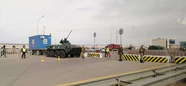
A checkpoint on the border of Nur-Sultan. (Photo: Terra Drone)
All entrances and exits from Nur-Sultan have been completely blocked as part of these measures, mobilizing multiple law enforcement agencies of the Republic of Kazakhstan. Armored vehicles, barriers, and concrete blocks are being used to man the movement from the surrounding villages of Talapker, Karaotkel (Ilyinka), Koyandy, Kosshy and Zhibek-Zholy, on the Nur-Sultan-Petropavlovsk highway.
An additional post has been set up by the municipal government of the Akmola region in Shubary to ensure there are no cases of non-compliance by the Kazakh population.
KazUAV has been directly involved in the collection of information, operational monitoring, and coordination of actions of the Police Department and the Coronavirus Spread Prevention Operational Headquarters for all these areas.
A KazUAV drone takes off to monitor the borders of the Kazakh capital of Nur-Sultan. (Photo: Terra Drone)
Using drone-mounted cameras with both visible and infrared sensors, the KazUAV team has completed hundreds of flight hours, broadcasting all captured data, as well as the exact coordinates of objects of interest, directly to the operational headquarters command center. This has led to the authorities discovering multiple bypass roads and irregularities in the locked-down area – without which, the quarantine measures could not have proven effective.
When it comes to remote monitoring of vast areas, unmanned aerial vehicles are one of the best tools available to public safety agencies today. As a leading drone service provider in Kazakhstan, KazUAV not only gave Kazakh first responders access to cutting-edge drone technology, the company also assisted the enforcement agencies with the vast experience of its team of specialists, trained to operate day and night in the toughest of weather conditions.
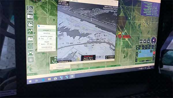
The UAV ground control station at the Coronavirus Spread Prevention Operational Headquarters in Nur-Sultan. (Photo: Terra Drone)
“As international experience has shown, restrictions introduced to prevent the spread of the coronavirus are the most effective measures to fight it,” said Dmitry Ivanov, development director, KazUAV. “Of course, it’s hard for everyone now; it is a challenging time for each one of us. But the call to stay home is more relevant than ever in the context of drones. We are familiar with carrying out critical tasks like monitoring floods or patrolling important events, but this was an emergency request which needed an immediate response.”
The scale and speed of the COVID-19 crisis has left policymakers searching for new tools to address an unprecedented challenge. Everything from faster testing to new treatments to more supplies for frontline providers is needed, and smart deployment of these resources requires an ability to track infections that is not yet available for a problem of the scale of COVID-19.
The recent economic stimulus package passed by Congress — the Coronavirus Aid, Relief, and Economic Security Act (“CARES Act”) – looks to fund this kind of tracking. Among its many priorities, the CARES Act appropriates half a billion dollars to the Centers for Disease Control and Prevention (CDC) for modernization of its public health data surveillance capabilities, and specifically directs the CDC to report to Congress on the development of a “public health surveillance and data collection system for coronavirus within 30 days.”
The legislation does not give much in the way of additional direction to the CDC, meaning that the CDC is likely to think expansively and look for proven models in other highly developed public health systems.
Disease surveillance efforts around the world have taken a variety of approaches, in many cases informed by experience in battling prior pandemics. Public health systems in places such as South Korea, Singapore and China were built on the lessons of the outbreak of Severe Acute Respiratory Syndrome (SARS) and similar conditions over the past several years.
Location-based tracking using GPS provides greater insight and precision than, for example, asking an infected patient to remember and re-trace his or her steps.
Among many other elements, these systems frequently employ GPS-enabled smartphone apps both to gather information and to target alerts to local populations. Location-based tracking using GPS provides greater insight and precision than, for example, asking an infected patient to remember and re-trace his or her steps.
As discussions of similar solutions have begun in the United States, privacy advocates have rightly pointed out the risks inherent in systems that necessarily gather and communicate health information and pair that information with location-based information provided by GPS. But both legally and practically, there need not be an exclusive choice between health information privacy and using GPS and other technology to gather and provide information about COVID-19.
On the legal front, HIPAA broadly exempts disclosures of protected health information for public health activities, allowing disclosures to public health authorities without first obtaining patient consent. Similarly, HIPAA permits data to be de-identified — subject to recognized standards laid out in regulations and guidance — and thereafter shared and used for research purposes, including public health research and similar purposes.
Legal avenues certainly exist to permit significant information sharing about COVID-19 in order to help protect public health.
Furthermore, federal authorities tasked with enforcing HIPAA have already signaled in guidance that they will take a flexible approach to enforcement in order to meet the exigencies of the crisis. Thus, while it is true that HIPAA has not been applied directly to a public health emergency on the scale of COVID-19, legal avenues certainly exist to permit significant information sharing about COVID-19 in order to help protect public health.
On the practical front, HIPAA also points the way to sensible decision-making that balances privacy interests with the needs of the crisis. First, de-identification provides a significant opportunity to share data in a way that is protective of privacy. Second, we should not assume that widespread participation — both in information gathering and information dissemination — must be involuntary in order to be widely adopted.
Smartphones users can — and should — be given a choice before enabling tracking features on their devices, just as they can and should be informed in a transparent way about what data would and would not be shared. HIPAA establishes a “minimum necessary” standard that should provide the guiding principle here: no more information should be shared than is necessary to accomplish the intended objective.
As we search quickly for tools to enable the kind of tracking that we have not undertaken before, we should be careful not to construct a false dilemma between privacy and efficacy — the two go hand in hand. Strong and transparent privacy protections are both possible and necessary to secure the public buy-in that is necessary to make public health surveillance work.
Jeremy Meisinger is a Boston-based attorney at Foley Hoag LLP.
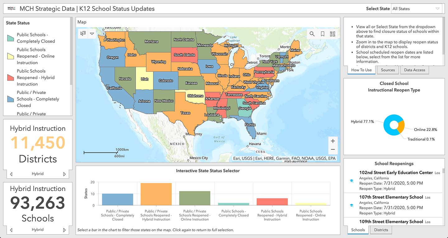
Location intelligence company Esri will be making data layers available on U.S. school closures during the COVID-19 pandemic, through a new partnership with MCH Strategic Data.
To help educational organizations as well as families across the nation better understand the situation in their communities, Esri and MCH have made school closure data accessible from a public dashboard.
Information on K-12 public and private schools include whether they are closed, plans for reopening school buildings, and the type of instruction they are offering during closures due to the epidemic.
MCH Strategic Data compiles and provides institutional information for the education, healthcare, government, and religious sectors.
“These datasets are useful for governments, school officials, and businesses providing leadership, resources, and community programs during the COVID-19 response,” said Ryan Lanclos, Esri director of public safety solutions. “But of utmost importance, this is a source of critical information for the community. It provides transparent and useful information that can help families develop a personal plan when they are feeling their most vulnerable.”
“Our customers depend on us to provide insight to the school market so they can respond effectively and appropriately during this challenging time,” said Kelly Holder, MCH chief information officer. “Our ability to rapidly compile and normalize changing data against our comprehensive U.S. database provides timely insight during an important time in the school planning cycle. This free map and database puts information into the hands of organizations who want to help schools and families now and in the coming months.”
As the COVID-19 outbreak has escalated rapidly across the globe, and with municipalities struggling to respond, MCH and Esri have built out additional resources like the MCH School Status Updates to help organizations quickly visualize and understand the current situation, as well as identify potential community risk areas when schools begin to open back up, and estimate the capacity needed to respond.
The Esri COVID-19 GIS Hub provides much of this essential data, along with case locations and social vulnerability, that communities and health organizations can use to inform their response.
For more information on Esri’s disaster relief support, visit esri.com/disaster.
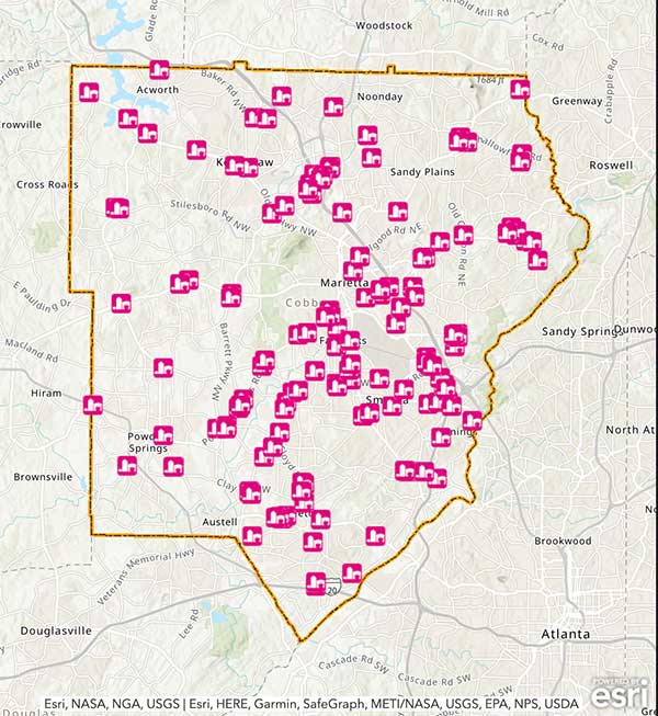
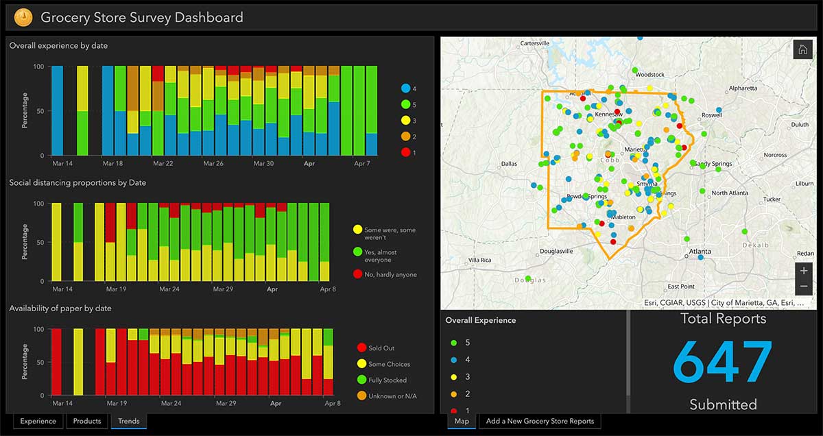
Cobb County, Georgia, is providing its residents with an app that tracks what grocery stores are stocking which essential goods, such as paper products, cleaning items and fresh produce.
The Cobb COVID-19 Grocery Stores and Inventory app gathers input from users, and the data is posted anonymously. Stores can be sorted by distance, senior hours and crowds. Cobb County is a suburb of Atlanta.
The Cobb County Geographic Information System (GIS) department created the app using Esri ArcGIS.
The United States Space Force’s Space and Missile Systems Center (SMC) has decided to reschedule the launch of GPS III SV03 (GPS III-3) from Cape Canaveral Air Force Station to minimize the potential of COVID-19 exposure to the launch crew and early-orbit operators.
Originally scheduled for late April, the launch is now projected for no earlier than June 30, pending a reevaluation in May.
“We do not make this decision lightly, however, given our GPS constellation remains strong, we have the opportunity to make a deliberate decision to maintain our mission assurance posture, without introducing additional health risk to personnel or mission risk to the launch,” said Lt. Gen. John F. Thompson, SMC commander and program executive officer for space.
The Lockheed Martin-built GPS III satellite will be the second GPS satellite launched on a SpaceX Falcon 9 rocket. It will be the first National Security Space Launch mission where SpaceX will attempt to recover the booster, reports Space News.
GPS III-3 brings the third modernized GPS III satellite to the operational GPS mission, and the team remains ready to execute. GPS III will bring three times better accuracy and up to eight times improved anti-jamming capability than its predecessor.
The current constellation is healthy with 31 satellites on orbit, allowing the team to take this strategic pause without gaps in coverage or capability.
“The GPS system supports vital U.S. and allied operations worldwide, unabated. As the COVID-19 pandemic is a threat to national security, likewise, rescheduling the launch is in the interest of national security,” said Gen. Thompson. “We have to get it right the first time, and protecting our people is just as important as cost, schedule, and performance.”
SMC still plans to complete the next three GPS launches this year. The team is taking the necessary steps to protect the health of personnel to allow a swift return to the mission.
“Some of the steps include procedural and facility modifications at the GPS III Launch and Checkout Capability (LCC) operations center and reducing the onsite crew size to provide adequate physical distancing, per CDC guidelines,” said Col. Edward Byrne, chief of Medium Earth Orbit Space Systems Division. “Once these efforts are completed, and the crews have rehearsed and are deemed proficient and ready to execute under these modified conditions, we fully intend to return to our launch cadence for deploying GPS III satellites.”
A leader of GPS III acquisition, SMC’s Production Corps is the United States Space Force’s acquisition office for producing and delivering GPS satellites, ground systems and military user equipment. The Production Corps’ agile program management techniques, smart business approach and close teaming with Lockheed Martin Space are enabling the production and delivery of GPS III’s new civil and warfighting capabilities by 2023. GPS delivers the “gold standard” of space-based positioning, navigation, and timing services vital to U.S. and allied operations worldwide, and underpins critical financial, transportation, and agricultural infrastructure that more than four billion users have come to depend on daily.
SMC’s Launch Enterprise, located at Los Angeles Air Force Base, California, is responsible for the acquisition and operation of launch vehicles, which includes mission assurance and launch safety. The Launch Enterprise is also responsible for leading the effort to certify new entrants to provide launch services for National Security payloads.
GPS III SV03 will be launched into operational orbit by a SpaceX Falcon 9 rocket. GPS III SV03 will be the second National Security Space Launch (NSSL) mission to be launched on a SpaceX Falcon 9 rocket and the first NSSL mission where a Launch Service Provider is recovering a booster.
The Space and Missile Systems Center is the U.S. Space Force’s center of excellence for acquiring and developing military space systems. SMC’s portfolio includes space launch, global positioning, military space vehicle communications, defense meteorological space vehicles, range systems, space vehicle control networks, space-based infrared systems, and space situational awareness capabilities.
SMC continues to deliver vital capabilities to the warfighter and the world, despite the challenges of COVID-19. Recent examples include the successful launch of AEHF-6 on March 26, Operational Acceptance of GPS III SV02 by Space Operations Command on March 27, and the inclusion of SV02 into the operational GPS constellation on April 1.
SpaceX’s Falcon 9 rocket orbited the first GPS III satellite on Dec. 23, 2018. (Photo: SpaceX)
Raytheon Technologies Corporation announced the successful completion of the all-stock merger of equals transaction between Raytheon Company and United Technologies Corporation on April 3, following the completion by United Technologies of its previously announced spin-offs of its Carrier and Otis businesses.
Headquartered in Waltham, Massachusetts, Raytheon Technologies is one of the largest aerospace and defense companies in the world with approximately $74 billion in pro forma 2019 net sales and a global team of 195,000 employees, including 60,000 engineers and scientists.
Raytheon Company shares ceased trading prior to the market open on April 3, and each share of Raytheon common stock has been converted in the merger into the right to receive 2.3348 shares of United Technologies common stock (previously traded on the NYSE under the ticker symbol “UTX”).
Upon closing of the merger, United Technologies’ name has changed to “Raytheon Technologies Corporation,” and its shares of common stock will begin trading today on the NYSE under the ticker symbol “RTX.” United Technologies shareowners will continue to hold their shares of United Technologies common stock, which now constitute shares of common stock of Raytheon Technologies Corporation.
Raytheon Technologies has a large, talented workforce to address the rapidly evolving needs of customers globally. The combined company expects to introduce breakthrough technologies at an accelerated pace across high-value areas such as hypersonics, directed energy, avionics and cybersecurity.
In addition, Raytheon Technologies has a strong balance sheet and cash flows to support critical business initiatives, including company and customer-funded R&D.
“Raytheon Technologies brings together two companies with combined strengths and capabilities that make us uniquely equipped to support our customers and partners during this unprecedented time. We will also play our part in the war on the COVID-19 pandemic, including doing everything we can to keep our employees around the globe safe and well,” said Greg Hayes, CEO of Raytheon Technologies. “As we move forward, Raytheon Technologies will define the future of aerospace and defense through our focus on innovation, our world-class people and our financial and operational strength to create long-term value for our customers and shareowners.”
“Today, we introduce Raytheon Technologies as an innovation powerhouse that will deliver advanced technologies that push the boundaries of known science,” said Tom Kennedy, executive chairman of Raytheon Technologies. “Our platform-agnostic, diversified portfolio brings together the best of commercial and military technology, enabling the creation of new opportunities across aerospace and defense for decades to come.”
Structure and Leadership
Raytheon Technologies has four market-leading segments focused on high-priority areas for
customers. (Note: 2019 net sales are prior to intercompany eliminations.)
Collins Aerospace Systems specializes in aerostructures, avionics, interiors, mechanical systems, mission systems and power controls that serve customers across the commercial, regional, business aviation and military sectors. The segment is led by President Stephen Timm, headquartered in Charlotte, North Carolina, with approximately $26 billion in 2019 net sales.
Pratt & Whitney designs, manufactures and services the world’s most advanced aircraft engines and auxiliary power systems for commercial, military and business aircraft. The segment is led by President Chris Calio, headquartered in East Hartford, Connecticut, with approximately $21 billion in 2019 net sales.
Raytheon Intelligence & Space specializes in developing advanced sensors, training, and cyber and software solutions — delivering the disruptive technologies its customers need to succeed in any domain, against any challenge. The segment is led by President Roy Azevedo, headquartered in Arlington, Virginia, with approximately $15 billion in pro forma 2019 net sales.
Raytheon Missiles & Defense provides the industry’s most advanced end-to-end solutions to detect, track and engage threats. The segment is led by President Wes Kremer, headquartered in Tucson, Arizona, with approximately $16 billion in pro forma 2019 net sales.
Raytheon Technologies’ executive leadership team is comprised of Tom Kennedy, executive chairman, Greg Hayes, chief executive officer, and Toby O’Brien, chief financial officer. Additional leadership biographies are available on the company’s website.
Raytheon Technologies Investor Call
Raytheon Technologies will hold an investor call to discuss United Technologies and Raytheon Q1 results on May 7 at 8:30 a,m. The call details will be provided prior to the results announcement, and the call will be webcast on the Raytheon Technologies investor relations website.
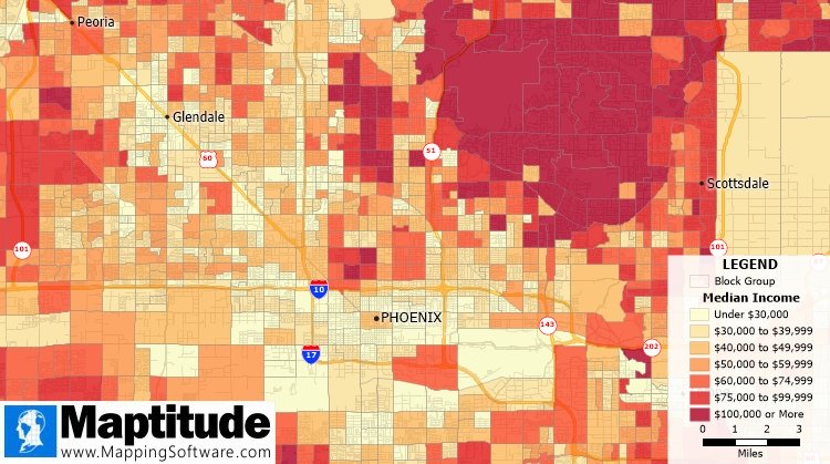
The Maptitude 2020 U.S. Census Blocks Groups data is now available for the entire United States, according to software provider Caliper.
The small-area Census Summary Level is packed with neighborhood information essential for making accurate geography-based decisions. Maptitude users can explore locations by income, income growth, daytime population, age, race, gender, ethnicity, buying power, occupation, employment status, housing characteristics, citizenship counts and more.
The wealth of data can be leveraged by data scientists and market research analysts using Maptitude mapping software, a comprehensive application for data exploration.
The 2020 Block Groups are priced at US$250 on the Caliper Store, and are also available as shapefile, KML, KMZ or GeoJSON for an additional fee. If you have any questions about Maptitude or data availability contact the Maptitude team.