Author: Tracy Cozzens

  • U.S. Space Force accepts control of GPS III SV02 amidst global pandemic

    U.S. Space Force accepts control of GPS III SV02 amidst global pandemic

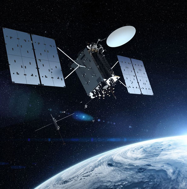
    The second GPS III satellite, nicknamed Magellan, has been designated healthy and usable.

    According to a Notice of Advisory to Navstar Users (NANU) issued by the U.S. Coast Guard, the satellite has been designated usable as of April 1, 1945 ZULU.

    The 2nd Space Operations Squadron (2 SOPS) accepted control of the Magellan on March 27 at the Schriever Air Force Base in Colorado.

    Designated Satellite Vehicle Number 75 (SVN75) in the GPS constellation, Magellan is the second GPS III satellite to be accepted into the program, and the first to be accepted during a global pandemic.

    The second GPS III satellite is encapsulated before launch. (Photo: Lockheed Martin)
    The second GPS III satellite is encapsulated before launch. (Photo: Lockheed Martin)

    “We’re continuing to make major strides even while working through this pandemic, and we continue to expand our capability to further the program along,” said Lt. Col Stephen Toth, 2 SOPS commander. “This is a huge, momentous occasion for us, that we’re reaching this milestone, that our programs are being delivered, that they’re being executed and the systems are performing as expected. Ultimately, we’re all very excited that we’ve accomplished this major milestone in the program’s history, and we’re very excited for the next things to come.”

    The new generation of GPS III vehicles have a 15-year design life and signals that are three times more accurate than the current generation.

    “[This means users will have] better accuracy anywhere in the world, with a user’s device being able to determine their location more reliably,” said Capt. Ryan Thompson, 2nd SOPS assistant director of operations.

    Additionally, the new satellites have eight times improved anti-jam capability, allowing the military warfighter to operate better in contested, degraded and operationally limited environments.

    The vehicles are designed to be forward and backward compatible, which allows them to adapt to the future while remaining fully adaptable to the previous generation of vehicles.

    Eight more GPS III satellites are scheduled to launch from now until 2025.

    Despite any challenges that may arise, 2nd SOPS remains focused on the mission and continues to make history in space.

    “As we’ve moved forward into the Space Force, we’ve taken a bigger mindset approach toward being warfighters,” Toth said. “What COVID has actually brought out of us is the full understanding of what it is to operate with a warfighter mindset. We may not be at war with an enemy per say, but we are definitely at war with the virus. My job is to ensure we continue to provide position, navigation and timing to the world. And we take that very seriously, so despite the virus, we’ll ensure that our mission continues.”

  • Sewio helps fight COVID-19 with ‘smart quarantining’

    Sewio helps fight COVID-19 with ‘smart quarantining’

    Sewio-logo

    Sewio — a UWB-based, real-time location system (RTLS) company — is offering companies free consulting and software licenses to help them install employee tracking technology.

    Current quarantining and other enforced measures are designed to save lives by containing the spread of the virus. Once these restrictions are lifted, the pressure to restart manufacturing operations will increase.

    Nevertheless, this brings the risk of a COVID-19-positive employee introducing the virus to the workplace, increasing the risk of infecting colleagues, endangering lives and placing the factory under quarantine again.

    With its precise accuracy, ultra-wideband RTLS enables employee tracking and monitoring of any employee who has come into contact with a newly identified infected person. According to Sewio, it can help make sure exposed staff members are tested and receive the treatment they need as quickly as possible.

    “UWB-RTLS-powered smarter, faster and selective quarantining helps save lives and keep mission-critical operations running at all times,” said Milan Simek, CEO at Sewio Networks.

  • Canada approves BVLOS drone flights with Iris

    MVT Geo-solutions, in partnership with Iris Automation, has been granted the first beyond-visual-line-of-sight (BVLOS) Special Flight Operations Certificate (SFOC) by Transport Canada using only onboard detect-and-avoid (DAA) systems.

    The approval was granted based on the utilization of Iris Automation’s DAA system, called Casia, which provides commercial drones with automated collision avoidance maneuvers.

    The waiver permits flights within the Unmanned Aircraft Systems (UAS) Center of Excellence’s controlled airspace Remotely Piloted Aircraft System (RPAS) test range in Alma, Quebec. This is the first BVLOS flight at the location leveraging only onboard DAA for air risk mitigation, and does not require ground-based observers or radar.

    BVLOS flights unlock autonomous drone use for economically beneficial commercial applications including infrastructure inspection, mining, mapping, agriculture, emergency response and package delivery.

    “Achieving the first BVLOS approval in Canada further validates our technology alongside multiple permissions we have already received from regulators in the U.S. and South Africa,” said Iris Automation CEO Alexander Harmsen. ”This technology is critical to safely integrate drones into the airspace along with manned-aircraft, and we look forward to unlocking commercial operations for our customers in Canada.”

    Iris Automation’s onboard computer-vision DAA system is an effective, scalable and cost-effective technology to enable commercial BVLOS operations.

    “The UAS Center of Excellence is looking forward to leveraging Iris Automation’s DAA system and existing flight expertise within our network to conduct BVLOS flights with MVT Geo-solutions,” said UAS Center of Excellence Director William de Keiser. “We will continue to develop our partnership with Iris Automation to provide training to local operators and enable BVLOS flights in Canada.”

    The first BVLOS flights are scheduled to take place within weeks. The resulting data will inform more complex BVLOS operations in the future.

  • PCCW Global and UniStrong to link GNSS tech with telecoms, airports

    PCCW Global and UniStrong to link GNSS tech with telecoms, airports

    PCCW and Unistrong will collaborate on developing GNSS technologies and services for the telecommunications and aviation industries.

    PCCW Global is the international operating division of HKT, a Hong Kong telecommunications service provider. Beijing UniStrong Science and Technology Corporation Limited is a navigation and positioning company.

    The collaboration intends to link satellite positioning to 5G mobile networks to provide positioning data accurate to within centimeters. The link will unlock new services for telecommunications providers rolling out new networks to support the internet of things (IoT), smart cities and the aviation industry.

    UniStrong’s experience in developing high-precision products, solutions and services will enable PCCW Global to integrate new services with 5G mobile infrastructure, providing high-precision positioning (HPP) accurate down to centimeter levels.

    This integration of precision positioning expertise and technologies has the potential to revolutionize industries such as commercial drone operations, autonomous vehicles and transportation, logistics, construction, agriculture and others.

    New Airport Technology

    The integration of technologies will also enable the provision of smart aviation solutions for airport authorities. Based on high-precision positioning and navigation technology, new airports will be able to leverage smart civil construction works that will facilitate safer and more efficient airport operations.

    These aviation technologies will also be able to integrate with a wide variety of IoT sensors, edge-computing capabilities, machine vision and other artificial intelligence (AI) technologies to create intelligent surveillance platforms capable of managing and enhancing many aspects of airport safety and efficiency.

    The installed base of GNSS devices in use globally is forecast to increase from 6.4 billion in 2019 to 9.6 billion in 2029, with Asia-Pacific continuing to account for more than half of the global GNSS market.

    In terms of global annual GNSS receiver shipments, the market is forecast to grow from 1.8 billion units in 2019 to 2.8 billion units in 2029, according to the 2019 GNSS Market Report by the European Global Navigation Satellite Systems Agency (GSA).

    “As a global ICT service provider with extensive high speed fiber networks and cloud services coverage worldwide, we are delighted to cooperate with UniStrong with the aim to offer unique, game-changing solutions in Satellite High Precision Positioning (SHPP) and Continuous Operating Reference Station (CORS) solutions ideally suited to the new era of 5G, IoT and smart cities,” said Benney Cheng, head of Strategic Project and Development, PCCW Global.

    “The cooperation between UniStrong and PCCW Global will further promote the development of professional solutions and applications that are oriented towards global users’ needs,” said Jun Shen, corporate vice president and chief scientist of UniStrong. “Based on GNSS technologies, and deeply integrated with communication technologies, Big Data, Industry 4.0, IoT, artificial intelligence and other technologies, these solutions will empower and influence more industries and countries, and promote BDS/GNSS global applications and international services worldwide.”

    Photo: Bill Oxford / iStock / Getty Images Plus / Getty Images
    Photo: Bill Oxford / iStock / Getty Images Plus / Getty Images
  • USDOT seeks university to help secure automated navigation

    USDOT seeks university to help secure automated navigation

    The U.S. Department of Transportation (DOT) announced competitive grant solicitation for a new University Transportation Center (UTC) specifically on Highly Automated Transportation Research.


    Photo: Resilient PNT Foundation
    Photo: Resilient PNT Foundation

    “People will not be comfortable getting into an automated vehicle or with platooning driverless trucks heading down the highway if they think… their GPS might be spoofed,” according to Diana Furchtgott-Roth, Deputy Assistant Secretary at the U.S. Department of Transportation at a recent presentation. She believes getting robust and resilient navigation right is a prerequisite for success with automated and autonomous systems.

    As part of this effort, her office is looking for a U.S. non-profit institution of higher learning to become a University Transportation Center (UTC) focusing on “Highly Automated Transportation Research.” A critical component of this new center’s efforts will be work on resilient positioning, navigation and timing (PNT) services.

    From the abstract:

    “Progress on the path toward integrating automated systems into the transportation domain for all modes of transportation (surface, aviation, and maritime) will be aided by additional research addressing challenges associated with ensuring resilient Positioning, Navigation, and Timing (PNT) services to support automated systems.

    “This University Transportation Center will complement the new Center of Excellence for Highly Automated Transportation Systems being implemented within the USDOT. Among the critical needs is research to support securing cyber resilient PNT receivers for use in automated systems. This UTC will carry out research to support the development of standards and or prototypes and incorporate existing U.S. Government guidance.“

    The department is also looking for UTCs for Communications Technology and E-Commerce Effects on Travel Demand; Implications of Accessible Automated Vehicles and Mobility Services for People with Disabilities; and Strategic Implications of Changing Public Transportation Travel Trends.

    According to a press release issued March 30, one institution will be selected in each of the four areas. The total initial funding available to is just shy of $5 million.

    Interested parties can find the opportunity here, and can call Nancy Wilochka at (202) 366-5128.

  • European GNSS Agency provides list of COVID-19 apps

    European GNSS Agency provides list of COVID-19 apps

    Photo: AntonioGuillem/iStock / Getty Images Plus/Getty Images
    Photo: AntonioGuillem/iStock / Getty Images Plus/Getty Images

    The European GNSS Agency, based in Prague, is providing on its website a list of location-enabled applications that it considers potentially useful in response to the COVID-19 pandemic.

    The applications range from those helping public authorities understand the dynamics of the outbreak to supporting citizens in their everyday lives by checking supermarket lines.

    The apps are sorted into four categories:

    • Tracking the COVID-19 pandemic
    • Queue management
    • Response management
    • Information dissemination

    If you are an application developer and you want to add your app to the list, contact [email protected].

  • Final steps underway to operationalize new GPS M-code signal

    Final steps underway to operationalize new GPS M-code signal

    GPS IIIF’s M-Code can be broadcast from a high-gain directional antenna in a concentrated, high-powered spot beam, in addition to a wide-angle, full-Earth antenna. (Artist rendering: Lockheed Martin)
    GPS IIIF’s M-code can be broadcast from a high-gain directional antenna in a concentrated, high-powered spot beam, in addition to a wide-angle, full-Earth antenna. (Artist rendering: Lockheed Martin)

    U.S. Space Force, Lockheed Martin upgrade Operational Control System (OCS) and refresh GPS constellation with new satellites.

    The final steps to fully enable the ultra-secure, jam-resistant military code (M-code) signal on GPS are now underway.

    As part of the U.S. military’s effort to modernize GPS, the U.S. Space Force has been steadily upgrading its existing GPS Ground Operational Control System (OCS). The Space Force recently announced Operational Acceptance of the GPS Contingency Operations (COps) upgrade, developed by Lockheed Martin.

    COps enabled control of the operational GPS constellation, now containing 21 M-code-capable GPS satellites, including Lockheed Martin’s first two GPS III satellites, until the next generation OCX ground control system is delivered.

    M-code availability on track for 2020

    The Space Force’s M-Code Early Use (MCEU) upgrade, delivered earlier this year, will enable the OCS to task, upload and monitor M-code within the GPS constellation, as well as support testing and fielding of modernized user equipment, prior to the completion of the next-generation ground control systems.

    This spring, work will begin to install the components needed to command and monitor the M-Code encrypted GPS signal, which enhances anti-jamming and protection from spoofing, as well as increases secure access for our forces, into the GPS OCS. M-code signals are available on all the on-orbit GPS IIR-M, IIF and III space vehicles.

    A key to enabling M-code is a new software-defined receiver Lockheed Martin developed and is installing at all six Space Force monitoring sites. The M-code Monitor Station Technology Capability (M-MSTIC) uses a commercial, off-the-shelf general purpose graphics processing unit (GPU) to cost effectively receive and monitor M-code signals. Operators can monitor the signal as needed. M-MSTIC complements MSTIC’s, which Lockheed Martin developed and fielded to replace aging hardware receivers that were becoming difficult and expensive to maintain.

    “Our warfighters depend on GPS signals every day for many critical missions, so anything we can do to make these signals more resistant to jamming and spoofing is extremely important — and available today,” said Johnathon Caldwell, Lockheed Martin vice president of Navigation Systems. “The more powerful GPS III/IIIF satellites coupled with Lockheed Martin’s upgrades to the GPS ground system are making that possible.”

    Second GPS III satellite joins GPS Constellation

    On March 27, the Space Force declared Operational Acceptance of Lockheed Martin’s second GPS III satellite, which was transferred to 2 SOPS control earlier that week. An M-code enabled satellite, GPS III SV02 has three times greater accuracy and up to eight times improved anti-jamming capabilities.

    GPS III also provides a new L1C civil signal, compatible with other international GNSS, such as Europe’s Galileo.

    Lockheed Martin is contracted to build up to 32 GPS III/GPS III Follow On (GPS IIIF) satellites to help modernize the GPS constellation with new technology and advanced capabilities. The delivery tempo for these modernized GPS satellites will allow for several launches per year. The third M-code enabled GPS III satellite, named “Columbus,” is expected to launch in April, 2020.

    Red Dragon Cybersecurity Suite

    Cyber defenses across the upgraded GPS system were recently evaluated by a government assessment team and passed the Operational Utility Evaluation. Lockheed Martin delivered the Red Dragon Cybersecurity Suite (RDCSS) Phase III upgrade during the fourth quarter of 2019, dramatically improving Defensive Cyber Operations (DCO) visibility into GPS network traffic.

    Other add-ons include user behavior analytics to analyze patterns of traffic and network taps to improve data collections.

    “GPS is an attractive target for our adversaries, so it was critical we bring our best cybersecurity defenses to the table,” said Stacy Kubicek, vice president of Mission Solutions Defense and Security. “Since we began sustaining the Ground OCS in 2013, we have systematically upgraded and replaced software and hardware — it’s now a very secure system.”

    Lockheed Martin has sustained the GPS Ground OCS since 2013. In November of 2018, the team completed the AEP 7.5 architectural change – replacing the hardware and software to improve resiliency and cybersecurity. In December of 2018, the Air Force awarded Lockheed martin the GPS Control Segment Sustainment II (GCS II) contract to further modernize and sustain the AEP OCS through 2025.

    The GPS III team is led by the Production Corps, Medium Earth Orbit Division, at the Space Force’s Space and Missile Systems Center, at Los Angeles Air Force Base. The GPS OCS sustainment is managed by the Enterprise Corps, GPS Sustainment Division at Peterson Air Force Base. 2 SOPS, at Schriever Air Force Base, manages and operates the GPS constellation for both civil and military users.

  • Raytheon to replace computer hardware on new GPS ground system

    Raytheon to replace computer hardware on new GPS ground system

    Photo: Raytheon
    Photo: Raytheon

    The U.S. Space Force’s Space and Missile Systems Center’s GPS Next Generation Operational Control System (OCX) program on March 26 instructed Raytheon to replace the computer hardware in OCX prior to system delivery.

    The IBM computer product line used in the system was sold to a Chinese company, Lenovo, in August 2014. At the time of the sale, the U.S. government identified this as a major impact to OCX by creating an unacceptable cyber risk. However, the government waited implement a fix until Raytheon showed promising program performance in delivering OCX.

    “Over the last two and a half years, since OCX came out of its Nunn-McCurdy breach, Raytheon has been executing as planned, giving us confidence in OCX’s ability to transition into operations,” said Lt. Gen. John Thompson, SMC commander.

    Software development was completed in the fall of 2019, and the program is in the integration and test phase. Within a year, Raytheon is expected to deliver a qualified software baseline capable of operating the GPS constellation, Thompson said.

    Until OCX is deployed, GPS will be operated using the Contingency Operations, or COps, supplied by Lockheed Martin.

    HPE chosen as hardware vendor

    In 2017, the federal government sponsored a hardware trade study with U.S.-based vendors to replace IBM’s hardware. As a result of the study, Hewlett Packard Enterprise (HPE) was selected as the vendor. The program then conducted a pilot project replacing the IBM hardware in the 17 external monitoring stations and four ground antenna sites, resulting in successful HPE replacement.

    “This gave us confidence that we had a viable OCX technical solution providing a long term sustainable hardware baseline that meets our stringent cyber security requirements,” said Lt. Col. Thomas Gabriele, SMC’s OCX materiel leader. “As Raytheon continues to track to their contractual commitments, addressing the unsupportable IBM cyber security risk is prudent to do pre-system delivery to the government.

    “Although this government-directed change will impact the Raytheon schedule, the government is holding Raytheon accountable to deliver qualified software prior to integrating on the HPE platform and deploying to operational sites,” Gabriele said.

    “By executing the fix now we eliminate $150 million in rework and retesting, and ensuring we deliver a system that is capable of transitioning to operations,” said Barbara Baker, SMC Command and Control Division’s senior materiel leader.

    Decades-old hardware

    Another benefit of the $378 million government-directed contract change is the opportunity to replace the now decade-old IBM hardware. This will improve system performance and increase the OCX program supportability posture.

    “OCX is critical to continuing high priority national efforts to modernize GPS with new military and civil positioning capabilities, including enhanced security, precision, reliability, and integrity. OCX will deliver sustained, reliable GPS capabilities to America’s warfighters, allies, and civil users,” Baker said.

    The OCX program is part of the GPS Enterprise Modernization. OCX will deliver two times more satellite capacity, modern cyber-secure infrastructure, improved accuracy, globally deployed modernized receivers with anti-jam capabilities, and improved availability in difficult terrain.

    “As a high interest program, we will continue to work with our industry partners to deliver a global GPS capability, Gabriele said.

  • Phase One launches 280-megapixel camera with Applanix GNSS

    Phase One launches 280-megapixel camera with Applanix GNSS

    Photo: Phase One Industrial
    Photo: Phase One Industrial

    Phase One Industrial has launched a 280-megapixel aerial photogrammetric system, with an image coverage width of more than 20,000 pixels.

    The large format enables unprecedented high-quality aerial survey productivity, the company said. Compact and lightweight, the new aerial mapping solution can reduce operating costs and produce better returns on investment than today’s traditional large format systems.

    The Phase One Industrial 280MP Aerial Solution consists of an iXM-RS 280F large format camera, Applanix GNSS/IMU receiver (POS AV series), Somag gyro-stabilized mount (DSM 400), Phase One iX Controller and iX Flight Management software.

    The system is a large format camera system that easily integrates with the DSM400 gyro-stabilized mount, creating a compact and lightweight system for use in a wide range of aircraft.

    At the system’s heart is the iXM-RS 280F, a dual-lens metric camera with 90mm lenses for capturing RGB information, providing precision imaging. Adding a near infrared (NIR) camera generates a 4-band configuration, most useful in agriculture, forestry and pipeline monitoring.

    The iXM-RS 280F camera generates a central projection image from two 150MP nadir images with equal ground resolution. The cameras’ backside illuminated CMOS sensor supports very high dynamic range at 83dB. Its high light sensitivity provides superb image quality in challenging low light conditions, enabling operators to take advantage of more flight hours per day and more flight days per year.

    “Our 280MP Aerial Solution is a bold and innovative approach to solving customers’ demands for affordable and reliable aerial mapping performance,” said Dov Kalinski, general manager, Phase One Industrial. “Previously, opportunities in the aerial mapping business were restricted due to high cost of equipment and limited aircraft options. While pioneering superior image quality, Phase One Industrial is creating more profitable possibilities in this exciting and important market.”

  • USDOT seeks to create 4 new university transportation centers

    USDOT seeks to create 4 new university transportation centers

    Photo: adamkaz/E+/Getty Images
    Photo: adamkaz/E+/Getty Images

    The U.S. Department of Transportation (DOT) has announced competitive grant solicitation for nearly $5 million for four new University Transportation Centers (UTCs).

    Through the Notice of Funding Opportunity, DOT intends to fund one UTC in each of the following specific topic areas:

    • Highly automated transportation systems research
    • Communications technology and e-commerce effects on travel demand
    • Implications of accessible automated vehicles and mobility services for people with disabilities
    • Strategic implications of changing public transportation travel trends.

    Only U.S. non-profit institutions of higher education are eligible to apply or to be members of a proposed UTC consortium. Non-profit institutions of higher education may include qualifying two-year institutions.

    “Our University Transportation Centers are not only the seeds of our future transportation system, they serve as living labs, bringing research to reality. Four new UTCs will address a variety of important 21st century transportation topics,” said Deputy Assistant Secretary Diana Furchtgott-Roth.

    Thee Tier 1 UTCs will support research needs that DOT has identified under two of the FAST Act research priorities (49 U.S.C. § 6503(c)(1)): “Promoting Safety” and “Improving Mobility of People and Goods.”

    The Notice of Funding Opportunity (NOFO) is available now. For more information on the UTC program, contact Nancy Wilochka, (202) 366-5128.

  • Drone Delivery Canada asks for COVID-19 use cases

    Drone Delivery Canada asks for COVID-19 use cases

    Drone Delivery Canada logo

    Drone Delivery Canada is reaching out to the healthcare industry for use case applications for drone deliveries related to COVID-19.

    The Toronto-based company, which has been designated an essential workplace by the Ontario Provincial Government, seeks use cases from health care organizations (hospitals, seniors’ homes, medical labs and related organizations).

    If organizations in healthcare and related industries have a use case, they should reach out immediately to DDC at [email protected] and also contact their local government official to support their use case.

    “In the news we are seeing COVID-19 related drone applications around the world, and Canada can particularly benefit from having DDC, a drone logistics leader, in its own backyard,” said Michael Zahra, president and CEO of DDC. “The current situation is an ideal use-case for our proven drone logistics solution to: limit person-to-person contact; bring needed medical and pharmaceutical supplies to Aboriginal, remote, rural and suburban communities; transport blood samples to laboratories for testing and deliver other relevant supplies needed for Canada to effectively manage the current situation.”

  • DJI joins with firefighting provider Rosenbauer on digital emergency response

    DJI joins with firefighting provider Rosenbauer on digital emergency response

    Photo: Michael Chapman/iStock Editorial / Getty Images Plus/Getty Images
    Photo: Michael Chapman/iStock Editorial / Getty Images Plus/Getty Images

    Aerial perspective and mobile operation management system combine to inform deployment, give increased situational awareness, and save critical time

    A new strategic partnership between DJI and Rosenbauer International AG will enable emergency scenarios to be dealt with quicker, more safely and more efficiently, according to the companies.

    DJI makes civilian drones and aerial imaging technology, and Rosenbauer manufactures fire service vehicles and firefighting equipment.

    The two companies will work together to bring the benefits of digital emergency response management to anyone involved in being called to tackle an emergency situation.

    Whether used by a private company at an airport or industrial facility, or a local fire department called out to an emergency even in severe weather, an aerial perspective combined with Rosenbauer’s operation management system enables the situation to be quickly assessed and informed decisions made regarding the safest and most efficient deployment of personnel.

    Rosenbauer’s operation management system is the information management system for firefighting operations that supports emergency crews on site with relevant information such as fire safety maps, hazardous material data or vehicle rescue sheets.

    Data from DJI’s drone fleet management software, FlightHub, will be integrated into Rosenbauer’s operation management system, giving additional visual and thermal data to the decision maker of the operation.

    The information can then be relayed to operational units at the scene on a tablet or displayed on monitors back at the command center giving a full overview of the situation. Informed decisions can be made in real time regarding the efficient and safe deployment of resources such as personnel, vehicles and other equipment.

    Data safety is paramount and all information that is delivered to the Rosenbauer operation management system in real-time, and from DJI’s FlightHub, is stored on a server in the highly secure computer center of a well-known European telecommunication firm. The data traffic is secured and encrypted. During deployment, the data is also synced with all mobile end devices so that every operational team has the same information, and it is kept in a closed loop.

    “Speed and a truly complete overall picture are key criteria for success when emergency service teams have to make purposeful decisions under time pressure. We have already supported their efforts to meet these criteria with our IT solutions, which range from efficient vehicle management to navigation, right through to alarm applications,” said Dieter Siegel, CEO of Rosenbauer International. “This cooperation with DJI enables us to consolidate our role as a digital pioneer while we work together to develop an integrated technology for comprehensive, data-based firefighting and disaster management.”

    “DJI is proud to bring its drone technology to support Rosenbauer’s excellence in fire apparatus manufacturing and its vision of empowering firefighters with the best possible tools for emergency response and disaster relief. At DJI, we aim to provide reliable, scalable drone offerings that empower firefighters, search and rescue and public safety teams to benefit from this technology,” said Roger Luo, President, DJI. ” It plays an increasing role in saving lives, time and resources on a daily basis. This integration is an important step for this long-term partnership, and our commitment demonstrates an increasing maturity in the adoption of drones for firefighting professionals.”