Garmin International Inc., a unit of Garmin Ltd., has chosen SiTime’s micro-electromechanical system (MEMS) timing solutions for several of Garmin’s automotive, aviation, marine, fitness and outdoor products.
“Garmin makes products that are engineered on the inside for life on the outside,” said Patrick Desbois, Garmin executive vice president of operations. “Our innovation focuses on developing technologies that enable our customers to enrich their experiences as they pursue their passions. SiTime’s MEMS timing solutions help extend battery life across several of our product lines.”
SiTime timing solutions are the heartbeat of customers’ electronic systems. With the deployment of 5G, internet of things (IoT) and automotive electronics in challenging outdoor environments, manufacturers will need timing solutions that enable environmental robustness and solve difficult challenges, such as power, size, and reliability. With the proliferation of electronic devices, the timing market is expected to grow to $10.1 billion by 2024.
“Garmin creates products for active people,” said Piyush Sevalia, executive vice president of marketing at SiTime. “Precise time is at the heart of every GPS receiver and impacts the speed of signal acquisition as well as position accuracy.
“Garmin’s outdoor products encounter many environmental stresses such as shock, vibration, rapid temperature changes and extreme temperatures. SiTime’s MEMS timing solutions are engineered to provide the highest level of robustness to such stressors and provide a powerful value-add to Garmin’s high-performing, robust and reliable products.”
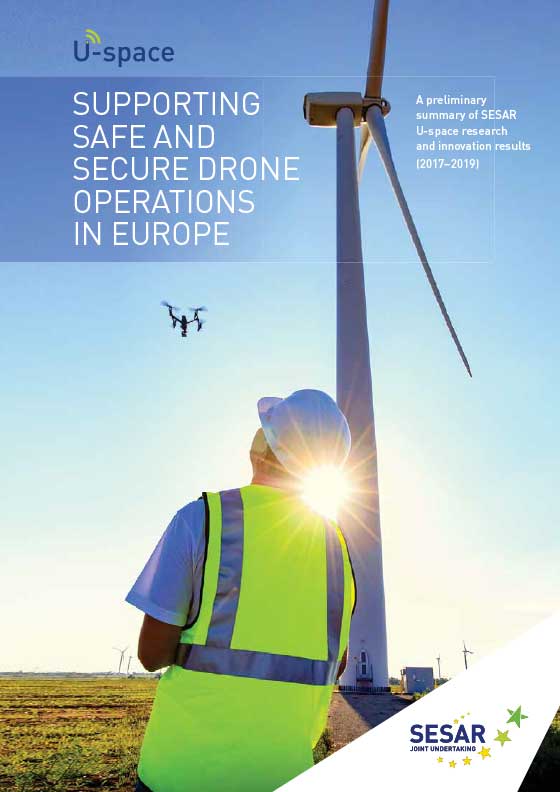
The research and demonstration projects addressed topics such as drone operations; critical communications; surveillance and tracking; information management; aircraft systems; ground-based technologies; cyber-resilience; and geo-fencing.
“Drones are disrupting business as usual in air traffic management,” said Florian Guillermet, executive director, SESAR Joint Undertaking. “A simple adaptation of our current air traffic management system is not enough; accommodating these air vehicles in the numbers forecast requires a new approach.”
The projects map progress on development of the technological capabilities and all services
required for making U-space a reality, starting with foundation services (U1) before progressing to initial services (U2), advanced services (U3) and finally full services (U4).
Results of the projects summarized in the brochure will be fully detailed in a comprehensive report, expected to be published in the second half of 2020.
Chart: SESAR JC
SESAR 2020
SESAR 2020 is a European Union innovative program for researching the future of air traffic management in Europe. It builds on its predecessor, SESAR 1, to deliver high-performing operational and technological solutions for uptake by the aviation industry.
With a budget of 1.6 billion euros between now and 2024, SESAR 2020 will support projects to deliver solutions in these four key areas:
GMV has been awarded the SUGUS project (Solution for E-GNSS U Space Service), which aims to speed the adoption of GNSS and Galileo in the unmanned aerial vehicle (UAV) segment and ensure safe airspace access by unmanned aircraft.
SUGUS is an 18-month, 485,000-euro European Union research and development project. A series of trials will be held to show the benefits of E-GNSS for drone operators as well as its approval by aviation authorities.
The demand for UAV services is steadily increasing, with the potential to generate significant economic growth, as recognized in the 2015 European Union Aviation Strategy. More recently, the 2016 European Drones Outlook Study (by SESAR — Single European Sky ATM Research) estimated that the European drone market will clock up 10 billion euros a year by 2035 and more than 15 billion euros annually by 2050.
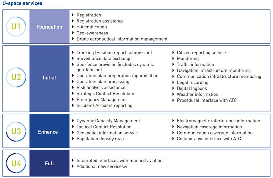
U-Space services
U-Space is a set of new airspace-management services and procedures designed to ensure airspace access too UAVs while looking out for operational security, the right to privacy and the safety of persons and infrastructure. These services rely on a high level of digitization and function automation, whether onboard the drone itself or part of the ground-based environment.
Several initiatives are underway in Europe to develop U-Space and work toward the safe and efficient coexistence of manned and unmanned air traffic.
At the same time, new European legislation on operating unmanned systems is providing a uniform, Europe-wide framework. The new regulation is broken down into three drone operation categories:
Open, calling for no AESA clearance or operator declaration
Specific, where both clearance and declaration will be necessary
Certified, reserved for riskier operations.
To help integrate drones into the airspace, SUGUS will center on the Open and Specific flight categories.
SUGUS tasks
SUGUS will demonstrate the benefits for drone operations of the measures implemented at service-provision level and the new EGNSS API (European GNSS application programming interface) to be implemented in the project.
These benefits included the mitigation of operating risks, improvement of preparation processes and clearance of the operator’s mission. Such measures as expected to ease future urban aerial mobility operations, such as aero taxis or parcel delivery.
For the first step in this endeavor, SUGUS will carry out a review of the results of previous EGNSS projects while also pinpointing the needs of drone operators and unmanned traffic service providers in complex operations and built-up areas.
This analysis will help to define and then implement the new EGNSS-based API.
SUGUS will also be running several flight trials in complex environments to prove the benefits of the drone-operation measures. The overarching idea is to raise awareness and contribute towards drone standardization and regulation to maximize the chances of the proposed services being implemented as a U Space service.
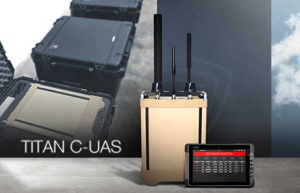
Titan C-UAS systems are deployed globally, protecting combat forces, civilians, and critical infrastructure. (Photo: Citadel Defense)
U.S. military, government and international customers opt for Citadel’s Titan for drone protection
Citadel Defense continues to experience rapid growth after being awarded several significant Defense and Homeland Security contracts for its C-UAS (counter unmanned aircraft systems) solutions.
Malicious drone activity, ranging from single-use hostile small unmanned aerial systems to drone swarms continue to threaten safety and national security. Over the past 18 months, Citadel has received orders for more than $17.5 million in products and services to support anti-drone initiatives around the world.
According to the company, the growth is a direct result of delivering reliable and effective force protection against individual drones and swarms for military, government and international customers over the past two years.
Citadel Defense’s automated counter drone solution uses artificial intelligence and machine learning as a reliable and scalable approach for addressing emerging threats.
To address the surge in global demand for Titan systems, Citadel has expanded its manufacturing capabilities in San Diego, California, to support production of up to 50 Titan systems a month. The company uses U.S. suppliers with more than 70% of components being sourced locally in Southern California to improve responsiveness when executing on urgent customer requests.
As new drones are released to the market, Titan systems receive new software to address the new threats. If Titan’s AI algorithms do not detect the threat right away, the company explained that it can deliver an end-to-end capability in 72 hours for most drones and less than 4 weeks for the most complex drone signals.
The use of AI, deepnets and adaptive countermeasures provide Titan with scalable force protection that can address the needs of the small unit, a large base or A mobile vehicle. The Titan system is being effectively integrated into layered solutions that combine radar, optics and kinetic countermeasures to help customers detect, identify, track, defeat and report on threat sUAS.
“Designing agility into our product development process from the beginning has allowed us to iterate in real-time alongside our customers and rapidly deploy new capabilities to improve mission outcomes,” said Christopher Williams, CEO of Citadel Defense.
As radiofrequency-based solutions become an important requirement for layered C-UAS solutions, Citadel has had its capabilities extensively evaluated by U.S. Army, Navy, Air Force, SOCOM, and DHS Test & Evaluation teams. Titan is being used to protect high-value assets in urban, rural and maritime environments.
“Designing our system to meet unpredictable mission scenarios was made possible by direct feedback from operators experiencing drone incursions on the front lines,” explained Williams. “The threat environment is always evolving which requires a product development approach that can adapt and respond. A combination of human-centered design and AI-powered technology have helped Citadel differentiate ourselves from traditional defense contractors.”
Analytics provider Teoco has been selected by Telstra — a mobile network in Australia — to assist with the development of its UAV strategy.
Telstra will use Teoco’s AirborneRF solution to assess the readiness of its radio access network for future UAV applications, including communications, navigation, surveillance, safety and identity.
Teoco is a provider of analytics, assurance and optimization solutions to more than 300 communication service providers (CSPs) and OEMs worldwide.
Already deployed by several tier-one operators globally, AirborneRF ensures effective, mission-critical connectivity to enable effective traffic management and control for UAVs in the lower airspace. Telstra will use the solution to develop a platform for enabling a multitude of mission-critical services, vital in supporting successful UAV operations.
The platform provides a link between cellular networks and aviation systems, such as air traffic management (ATM), unmanned traffic management (UTM) and flight information management systems (FIMS).
TEOCO’s AirborneRF solution will play an important role in assisting Telstra enable a safe, equitable, secure and reliable urban air space platform. This has become all the more important to Telstra following Uber’s decision in 2019 to use Melbourne as one of three pilot cities to test out its “flying taxis” — the pilot is expected to begin this year, with commercial operations planned for 2023.
Telecommunications companies can provide needed UAV services via their mobile networks. For the internet of things (IOT), they can provide drone registration, activation and identification. For 5G, they can provide super low-latency remote command and control and high-resolution video carriage.
“We have been running a number of drone-related technology assessments with various industry customers, within law enforcement, humanitarian aid, post disaster, first responders and city councils, over the past 12 months,” said Thomas Neubauer, vice president of Business Development, TEOCO.
“Commercial UAVs present a huge opportunity for [[telecommunications]] operators, but only if supporting mobile networks deliver the required connectivity to keep them airborne,” Neubauer said. “Mobile networks were not designed to meet the needs of the aviation industry, so tight focus is needed to guarantee the quality of service needed to safeguard the additional revenue that connected skies promise. Our Airborne RF solution offers this guarantee to a growing number of major operators around the world.”
For an industry that makes its living identifying people and objects at a particular point in space, the geolocation industry — made up of applications providers, mapping companies and device manufacturers — has been very slow to make the move from two dimensions (2D) to three dimensions (3D). There is no excuse for this, as the ability to locate in 3D is fully tested and operable. What explains the holdup and what is being done to meet the growing need for 3D solutions?
Industry participants recognize the inevitable move towards 3D but give four main reasons for the delay:
There is a lack of awareness about some of the robust, scalable solutions that are available for deployment today
Businesses continue to make money from 2D applications
The investment required for 3D applications is too high
The eco-system for 3D applications is not fully developed
It seems that applications using location data simply rely on whatever information is made available through devices, mostly driven by GPS. There are more specific location technologies that offer fully tested, citywide vertical location solutions.
Despite years of deployments and generating effective use cases in two dimensions, the industry must do a better job of keeping up with technology advancements, especially those most likely to benefit from 3D location, and articles like this help!
But why is there a lag in the industry to move to a 3D world?
2D complacency
The explanation for the lag in moving to 3D is that the geolocation industry is still making money from 2D applications and, as the old saying goes, “If it’s not broken don’t fix it.”
While it’s true that many non-mission critical applications are getting along fine using 2D and will for the foreseeable future, the need for 3D is now. At a basic level, traffic directions don’t really require a 3D layout of the topography of your daily commute, although I could argue the traffic use case would benefit from knowing whether traffic on a map is on an overpass or ground level roadway. Certainly rideshare companies could benefit from communicating to their customers what level in a parking garage or airport they are on.
Other use cases are demanding more sophisticated 3D technology. One of the initial drivers for high-accuracy 3D (and indoor) location has been the needs of the public safety community. When lives are at stake, first responders require the most specific possible location accuracy in order to quickly find emergency callers and others needing help.
Beginning in April 2021, Emergency Communications Centers (911 call centers) will receive vertical location of emergency callers from wireless carriers. Computer-aided dispatch (CAD) systems are exploring how best to incorporate this information and direct first responders to the 911 caller’s 3D or floor-level location.
The benefit is obvious, as emergency callers cannot always provide their exact location to the 911 operator, so technology fills the gap. Other industries ranging from mining to healthcare to enterprise security similarly are also demonstrating demand for 3D applications, and we are seeing moves to meet this demand, but there is a long way to go.
High stakes
Another reason for the relatively slow development of 3D applications is the investment required. Even with a demonstrable demand across several industries, many players in the geospatial industry aren’t willing to invest funds to pioneer new solutions.
For every big player like Samsung or Apple, who have committed to developing state-of-the-art 3D sensors in their devices, there are many small players who must instead follow the market and adopt white-label solutions that don’t require as much upfront investment.
While it’s true that some 3D technologies can require significant investment and a committed strategy on the part of geospatial industry players, locating devices in 3D is possible today and there is a huge potential to serve new markets and improve business and consumer applications.
The 3D eco-system
As the market for commercial applications reaches a tipping point where 3D is not just a curiosity but is becoming a must-have for many consumers and businesses, the industry ecosystem must step up and deliver all parts of the solution. The mapping industry presents an interesting use case in this regard.
Digital maps have been in use for years, since the advent of the first fleet tracking devices in the 1980s, which led to the widespread use of consumer car tracking systems, and then onto Waze and other Smartphone-based mapping applications. Even these maps, which are huge advancements over their predecessors, do not fully reflect the 3D world we live in, and generally do not include accurate maps of the indoor environments in which we spend most of our time.
The next step in mapping is the digitization of entire buildings and other structures to create accurate 3D representations. However, even pioneers in this space aren’t fully utilizing 3D technology throughout their product roadmap, and, until there is a fully developed 3D ecosystem, it’s difficult for a company to go ahead alone.
As one leading company explained to us, without a consistent protocol for the use of 3D data and its conversion into 3D maps, they can’t justify converting their entire production from 2D, so they instead create 3D maps as one-offs where needed. They haven’t yet seen the critical mass in the industry required to go full 3D, and they are still working with, and making money from, 2D partners.
They are preparing for the time when the industry is fully 3D, which they believe will come soon.
A 3D world
Stepping back and taking a broader view of where we are, I think we are witnessing an industry in transition. With the deployment of city-wide, scalable location solutions that incorporate location data from a variety of sources, the initial building blocks are in place for the move to a fully 3D world.
Pioneering companies are going after growing demand (and in some cases creating that demand), even with limited resources, and seeding an ecosystem for others to build upon. I would in fact challenge the industry to produce a use case that would not benefit from improved location and 3D awareness — from the daily commute through complex freeway systems to shoppers navigating a multi-story mall to find a specific retailer, to protecting workers running large hotels, and more, the applications are endless and promise to multiply as users realize the benefits of 3D technology.
It is only a matter of time until the location industry will fully embrace the fact that the world indeed is not flat.
About Matt Rothschild
Matt Rothschild
Matt Rothschild is the Mountain View-based Head of 3D Location Customer Engagement for Polaris Wireless. He is a wireless and telecommunications industry leader with more than 20 years’ experience leading sales, marketing, product and operations organizations internationally. Rothschild successfully led sales and marketing teams for Nokia in Asia (Singapore), the Middle East & Africa (Dubai) and the Americas (Miami/Silicon Valley). Most recently, Rothschild led the Nokia/Microsoft acquisition and integration for North America, building partnerships with key mobile operators and channel partners, as well as building important ecosystem and developer relationships for the Windows platform.
What are the key obstacles to widespread adoption of 3D positioning and guidance in the construction industry?
Ismael Colomina, GeoNumerics
“Construction site monitoring with UAVs requires regulated standard scenarios that allow flying over people and in urban areas without spending weeks obtaining the needed permissions. It also requires the development of critical UAV components, especially the guidance, navigation and control (GNC) systems. Safe UAV navigation — guaranteeing positional accuracy with small probabilities of actual errors larger than the specified ones — is still under development and will involve a multi-sensor navigation system. Current GNSS augmentation systems, such as WAAS and EGNOS, may not be appropriate for flights in the very-low-level (VLL) airspace.” Ismael Colomina, GeoNumerics
Members of the EAB
Tony Agresta Nearmap
Miguel Amor Hexagon Positioning Intelligence
Thibault Bonnevie SBG Systems
Alison Brown NAVSYS Corporation
Ismael Colomina GeoNumerics
Clem Driscoll C.J. Driscoll & Associates
John Fischer Orolia
Ellen Hall Spirent Federal Systems
Jules McNeff Overlook Systems Technologies, Inc.
Terry Moore University of Nottingham
Bradford W. Parkinson Stanford Center for Position, Navigation and Time
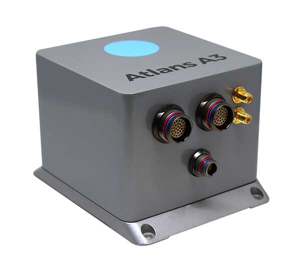
iXBlue has launched a new range of FOG-based inertial navigation system (INS) dedicated to land and air mobile mapping applications, the Atlans Series. iXBlue is high-tech company specializing in the design and manufacturing of advanced navigation and georeferencing solutions.
Based on iXBlue’s fiber-optic gyroscope (FOG) technology, the Atlans Series is a scalable range of north-seeking and north-keeping inertial navigation systems. They provide FOG performance to the full spectrum of land and air mobile-mapping applications and offer highly accurate positioning (up to 0.01 meter) in all conditions, including within GNSS-denied environments such as urban canyons, mountainous or forests areas.
“Our existing high-grade Atlans A7 INS had already been adopted as the preferred georeferencing solution by leading U.S. companies operating in the pavement condition survey industry,” explained Marine Slingue, vice president, iXBlue. “Having identified the high potential of our technology for other land and mobile mapping applications, we decided to develop a complete range of scalable INS that each meet the specific requirements of every applications. With our new Atlans Series INS, we are now bringing the unrivaled georeferencing accuracy performance offered by the FOG technology to all land and air mapping applications, enabling robust and uninterrupted data-acquisition operations.”
Quick and simple to install on all platforms, the new Atlans Series INS offers efficient “set-and-forget” operations for a wide range of land and air applications including asset inventory, pavement condition survey, vehicle automation, HD mapping, automotive testing, ground-truth, airborne surveys (UAVs, planes, helicopters), as well as precision pointing.
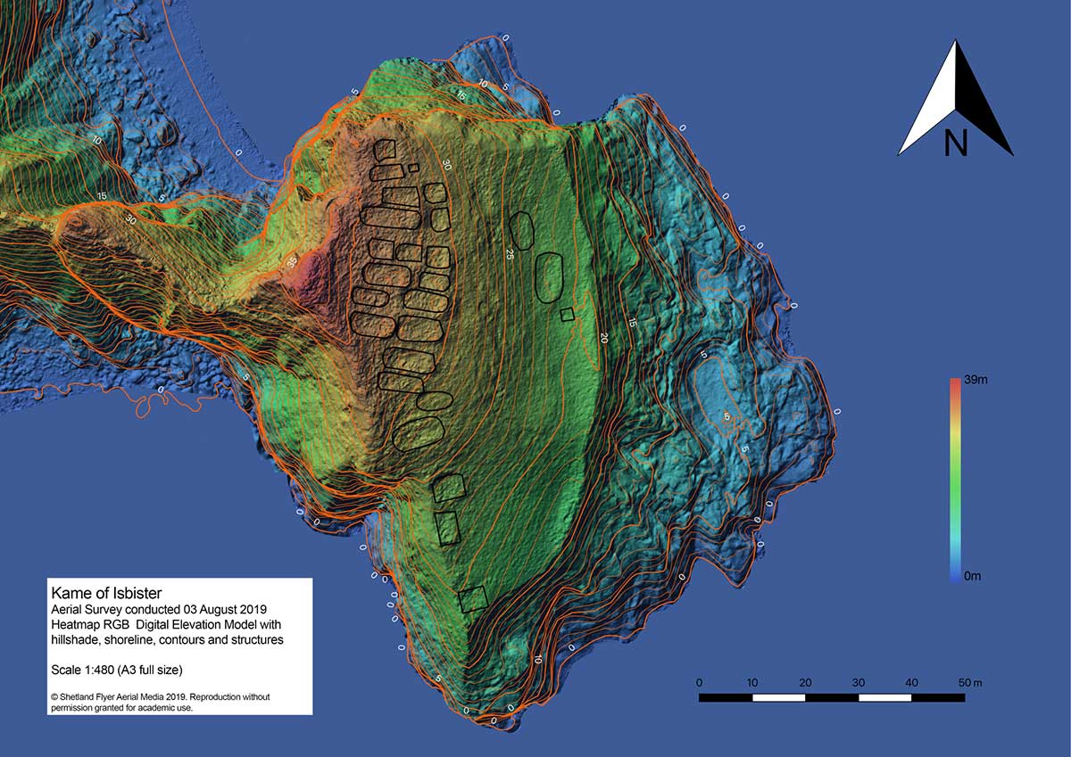
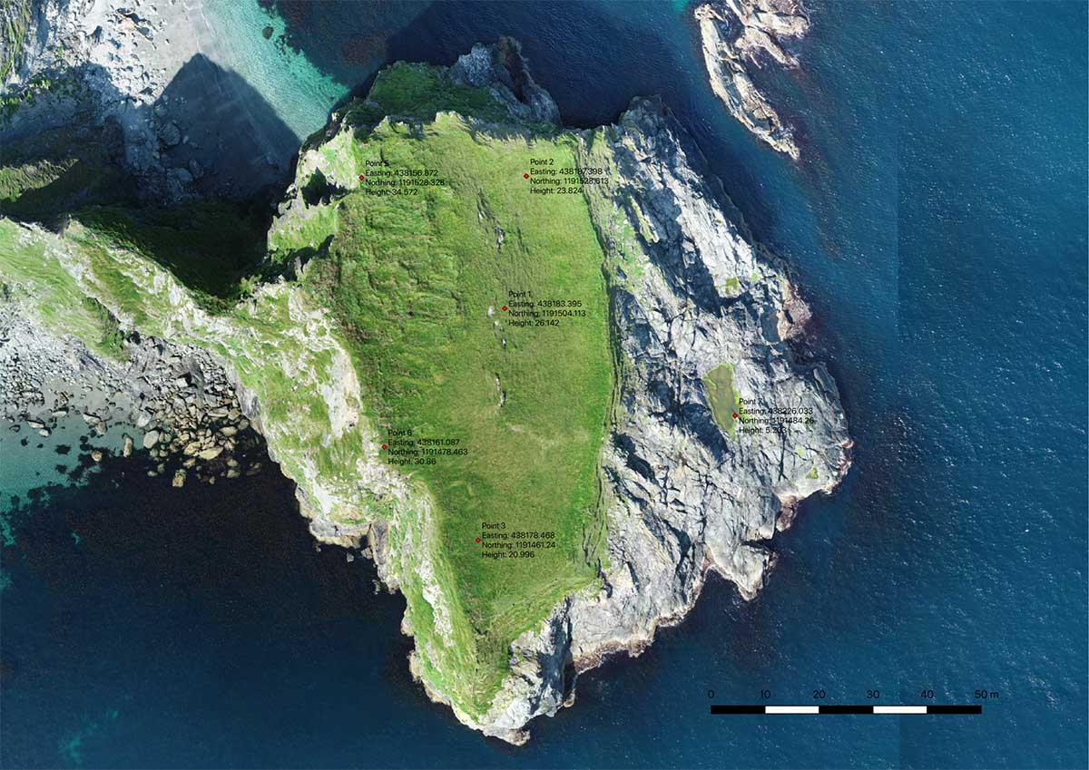
The mysterious and fascinating Kame of Isbister is situated in Shetland’s north mainland near the North Roe. The location has been studied several times, including by the Extreme Archaeology TV series in 2003. The uninhabited grassland continues to attract explorers because of a series of secret structures.
Those structures are hidden on the sea-faced slope and can’t be seen from the land nearby. One theory posits that it’s an eremitical monastery settlement. The late Pictish/early Medieval site is hard to access — and that’s where drones coupled with GNSS receivers helped explorers.
Because the site is hard to access, the team decided to use the DJI Phantom 4 RTK SUA (drone and base) with two flights. One flight captured both the Kame and a piece of the mainland for context, with a ground sample distance (GSD) of 2.4 centimeters/pixel (cm/px). The second flight was on a shorter GSD of 1.9 cm/px to capture detailed pictures of the cape and structures.
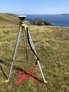
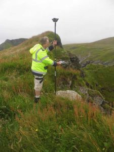
Before the survey, the team used the Emlid Reach RS+ real-time kinematic (RTK) receiver to identify and establish the base mark for the drone on the mainland nearby.
Photo: Emlid
The Reach RS+ collects ground control points. (Photo: Emlid)
Ground control point locations. (Image: Emlid)
The base mark was then post-processed using data from the OS Net reference station in Lerwick. Considering the long baseline (52 kilometers), it took the team four hours to observe the mark with Reach RS+. Later, when the archaeologists managed to climb the headland, the RTK receiver collected several noticeable control points.
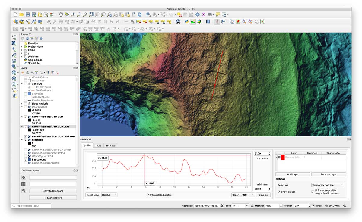
Creating the 3D model. During both flights, the drone’s base was sending corrections in RTK mode. In post-processing, horizontal accuracy of the processed map initially was within 10 cm with vertical at 15 cm. After adding the control points gathered with the RTK receiver, the error was reduced to 6.5 cm, significantly increasing the accuracy of the model.
The team performed the GIS processing in QGIS 3.4 LTR.
Screenshot: Emlid
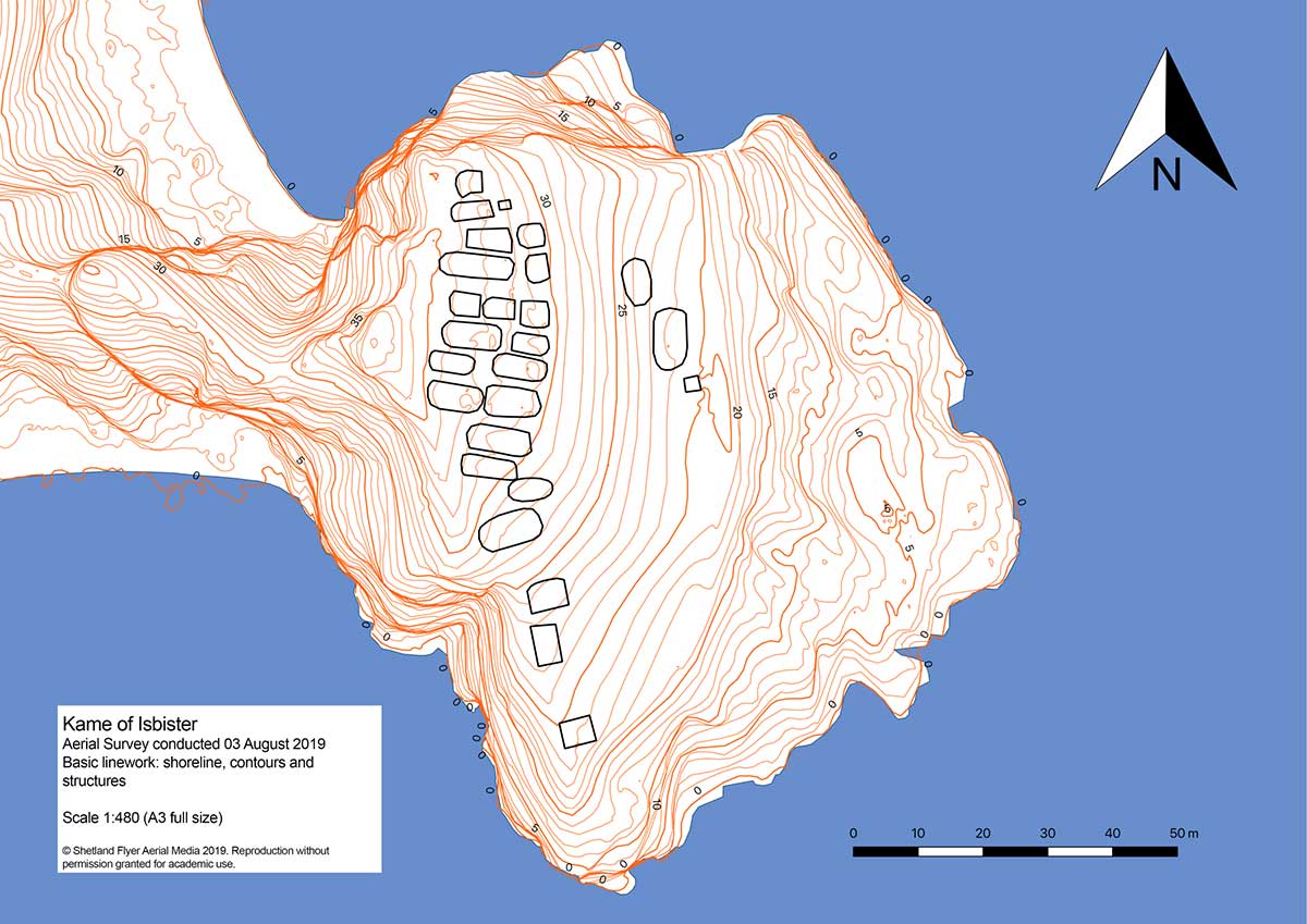
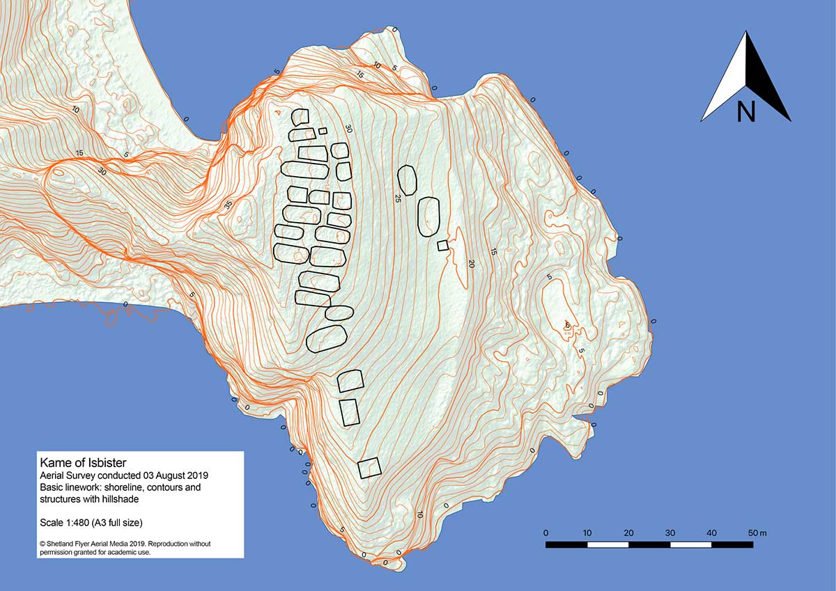
Despite the long grass, they managed to distinguish each structure out of the orthomosaic using the 32-bit floating point raster digital elevation model (DEM). The team created a basic map with structures and contours, a hillshade version and a heat map.
With proper preparation and setup, a GNSS RTK receiver with a drone can gather enough high-accuracy data to create accurate models and maps of an archaeological site — even if it’s hard to reach.
Shoreline contours and structures. (Image: Emlid)Shoreline contours and structures with hillshade. (Image: Emlid)3D model: The heatmap of the Kame of Isbister shows elevations and the archaeological site. (Image: Emlid)
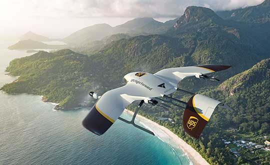
UPS Flight Forward (UPSFF) is collaborating with German drone-maker Wingcopter to develop the next generation of package delivery drones for a variety of use cases in the United States and internationally. UPSFF is a subsidiary of UPS dedicated to drone delivery.
UPS chose Wingcopter for its unmanned aircraft technology and its track record in delivering a variety of goods over long distances in multiple international settings.
“Drone delivery is not a one-size-fits-all operation,” said Bala Ganesh, vice president of the UPS Advanced Technology Group. “Our collaboration with Wingcopter helps pave the way for us to start drone delivery service in new use-cases. UPS Flight Forward is building a network of technology partners to broaden our unique capability to serve customers and extend our leadership in drone delivery.”
Drone fleet. As part of this collaboration — UPSFF’s first new relationship with a drone manufacturer since its formation — both companies will work toward earning regulatory certification for a Wingcopter unmanned aircraft to make commercial delivery flights in the United States. It also is a critical step toward building a diverse fleet of drones with varying capabilities to meet potential customer needs.
The Wingcopter drones feature vertical takeoffs and landings in tight spaces, transitioning to efficient, high-speed horizontal flight, enabling ranges suitable for a variety of uses. These capabilities will allow UPSFF to begin developing solutions that, if approved, will go well beyond the healthcare and retail industries to solve long-standing challenges for high-tech, industrial manufacturing, hospitality, entertainment and other customers.
Wingcopter drones have taken part in numerous beyond-visual-line-of-sight (BVLOS) projects and been used by diverse customers around the world — from commercial, factory-to-factory deliveries to life-saving humanitarian projects and emergency medical supply.
For example, Wingcopter delivered insulin to an Irish island in the North Sea that is frequently cut off from the mainland because of bad weather. On the South Sea island of Vanuatu, the start-up, on behalf of the local Ministry of Health and supported by UNICEF, successfully set up an on-demand vaccines supply, delivering the urgently needed serums within minutes to multiple different health centers.
Core innovation. The company’s electric vertical takeoff and landing drones have a patented tilt-rotor mechanism, which enables a seamless transition between two drone modes: multicopter for hovering and fixed-wing for low-noise forward flight. The aerodynamic Wingcopter aircrafts operate with stability even in harsh weather conditions.
In 2019, UPSFF began operating commercial drone delivery flights in the UPS network, starting with delivery service at WakeMed’s flagship hospital and campus in Raleigh, N.C. Since then, the company has delivered thousands of medical samples via drones, supplementing a ground courier service.
UPSFF later announced plans to establish drone delivery services on several healthcare campuses and has been exploring the use of drones to deliver retail, prescriptions and medical products in residential settings.
In September 2019, UPSFF received the U.S. government’s Standard Part 135 certification to operate a drone airline, and has also completed drone deliveries under the U.S. Federal Aviation Administration’s Part 107 rules within the FAA’s Integration Pilot Program.
“We are proud to partner with UPS, a global giant in delivery and logistics. Together we aspire to extend the speed and reach of package delivery,” said Tom Plümmer, Wingcopter chief executive officer and co-founder. “Our vision has always been to leverage technology to improve the lives of people around the world, and the strategic relationship with UPS will further accelerate our growth and global expansion, strengthening our role as an industry leader in drone technology.”
With a speaker and four microphones, drones can echolocate like bats
Mathematicians at Purdue University in West Lafayette, Indiana, have found that drones can determine position with echolocation.
The signal-processing research has potential applications for people, underwater vehicles and even cars, said Mireille “Mimi” Boutin, a Purdue University associate professor of mathematics and electrical and computer engineering.
Boutin and Gregor Kemper, a professor of algorithmic algebra in the Department of Mathematics at the Technical University of Munich, have worked to reconstruct the wall configuration of rooms by using echoes picked up by microphones on the drone.
Mathematicians found a method to hear the shape of a room using four microphones mounted on a drone. Pictured: Mireille Boutin. (Photo: Purdue University)
When a microphone hears an echo, the time difference between the moment the sound was produced and the time it was heard is recorded. That time difference shows the distance traveled by the sound after bouncing on a wall — much like bats use echolocation to orient themselves with their surroundings.
The challenge is to determine which distance corresponds to which wall, a process called echosorting. Sorting the echoes accurately ensures that all the walls heard are truly there. This way, the algorithm used does not produce “ghost” walls.
The research is directly related to two complementary problems in engineering: localization (determining where you are in an environment) and mapping (determining the shape of your environment).
The research, which uses methods from commutative algebra, proves that it’s possible for a minimal setup of four microphones arranged in a non-planar shape, along with a loudspeaker emitting a singal signal, to reconstruct a room.
The microphones and loudspeaker could be mounted on a moving car, a robot navigating in an indoor environment, or an underwater vehicle exploring a wreck in the ocean. Some of these situations put restrictions on rotations and translations that can be applied to the microphone configuration. The impact of such restrictions on the reconstruction problem will also be studied in future work.
The next steps will be to consider other scenarios, such as when the movement of the drone is restricted, or when the drone listens to the echoes of consecutive sounds as it is moving.
Citation. “A Drone Can Hear the Shape of a Room,” by Mireille Boutin and Gregor Kemper, SIAM Journal on Applied Algebra and Geometry, 4(1), 123–140, Published online Feb. 6, 2020, https://doi.org/10.1137/19M1248534.
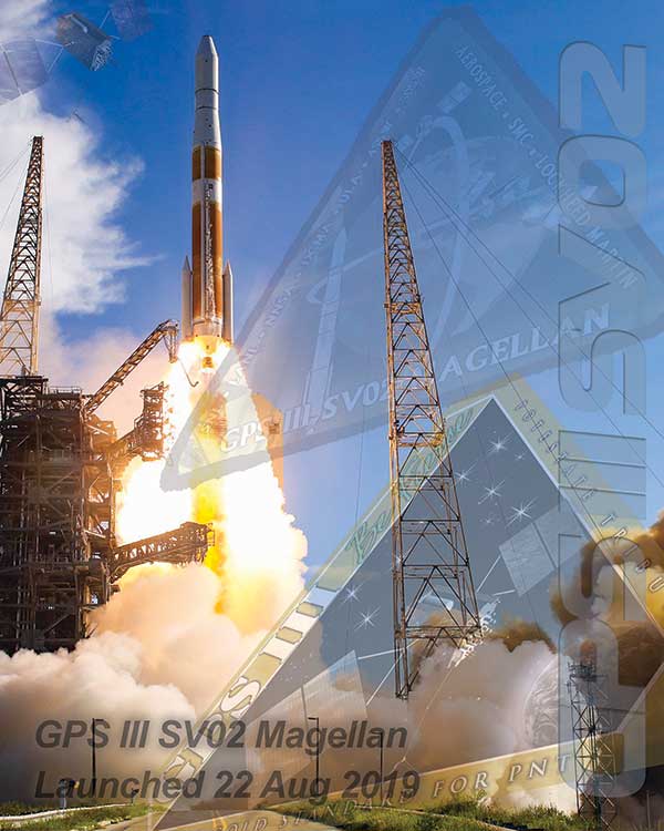
On March 23, the U.S. Space Force’s Space and Missile Systems Center successfully transferred the second GPS III space vehicle (GPS III SV02) to Space Operations Command.
GPS III SV02, dubbed “Magellan” in honor of Ferdinand Magellan, the Portuguese explorer who led the first expedition to circumnavigate the Earth, is now officially under the control of the Second Space Operations Squadron located at Schriever Air Force Base, Colorado.
GPS III SV02 was launched on August 22, 2019, aboard a United Launch Alliance Delta IV Medium+ launch vehicle from Cape Canaveral Air Force Station, Florida.
GPS III satellites deliver positioning, navigation and timing information with three times better accuracy, and up to eight times improved anti-jamming capability than its predecessor. This is crucial for the warfighter, who will benefit from the increased power, accuracy and protections provided by the newer GPS III systems.
“This marks our second transfer of Satellite Control Authority for the GPS III program as we continue to modernize the GPS constellation with more capable and resilient systems,” said Col. Edward Byrne, chief of Production Corps’ Medium Earth Orbit Space Systems Division. “It’s only through the hard work, professionalism, and dedication of our entire government and industry partner team that we can successfully transition GPS III SV02 to operations.”
The GPS III spacecraft has a 15-year design life, 25 percent longer than the last generation of GPS satellites currently on-orbit. Additionally, it delivers new capabilities, such as a fourth civilian signal (L1C), designed to enable interoperability between GPS and international satellite navigation systems, such as Galileo. GPS III satellites will also bring the full capability of the military code (M-code) signal, increasing anti-jam resiliency in support of the warfighter.
These continued improvements and advancements to the GPS system make it the premier space-based provider of positioning, navigation, and timing services for more than four billion users around the globe.
U.S. Space Force’s Space and Missile Systems Center, located at Los Angeles Air Force Base in El Segundo, California, is the U.S. Air Force’s Center of Excellence for acquiring and developing military space systems. Its portfolio includes the Global Positioning System, military satellite communications, defense meteorological satellites, space launch, range systems, satellite control networks, space-based infrared systems and space situational awareness capabilities.