ARPAS-UK — the Association of Remotely Piloted Aircraft Systems UK — is requesting the nation’s drone operators to let them know whether they could help fight the battle against coronavirus.
“We are aware there are thousands of Commercial Drone Operators out there; we may need your help,” ARPAS-UK said in a statement to the drone industry.
ARPAS-UK said it is “working hard to push the capabilities of the drone industry and making sure that government departments are reminded of the expertise and capabilities of the drone community in the UK.”
ARPAS-UK is especially targeting relief for emergency services, as well as delivery of emergency food and medicine to vulnerable people, spraying of disinfectant, and collection of imagery and video to help monitor various situations.
Current activities that could be expanded include vital inspections necessary to keep infrastructure running or maintain safety, such as monitoring following floods or environmental activity, and monitoring gas levels on sites.
ARPAS-UK is creating a secure database of the information that will be destroyed when no longer required. To fill out a form for the database, visit this page.
In response to the ongoing coronavirus pandemic, the test campaign for the first two satellites of Galileo’s Batch 3 has been suspended.
The suspension is based on the medical advice for social distancing — too high a concentration of people is needed on site if testing were to continue, according to the European Space Agency (ESA).
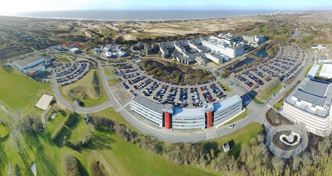
An aerial view of ESTEC. The Erasmus building is at front right. The T building (home to ESA’s Galileo team) is in the foreground. (Photo: ESTEC)
The satellites are based at the ESTEC Test Centre in the Netherlands for engineering tests ahead of launch. The stored satellites are being monitored by staff visiting ESTEC every few days, to verify that all is in order.
Other Galileo-related testing continues with the aim of supporting future launches. ESTEC-based lifetime testing of the next set of rubidium atomic clocks is set to continue, involving on-site monitoring every few days.
Working from home
ESA’s Directorate of Navigation has shifted to teleworking while also ensuring the continuity of essential tasks, in particular the continued delivery of positioning, navigation and timing services of both Galileo and EGNOS.
The ESA team is using video and audio conferences to continue meetings with the industries involved and minimize the impact on the deliveries of EGNOS upgrades, Galileo Batch 3 satellites, and preparatory work for Galileo Second Generation.
The national, local and industrial decisions on travel, meetings and quarantine are impacting the ability to deliver all ongoing commitments, so measures are being taken to minimize their impact, ESA said in a press release.
Priority has been given to ensure continued operations of both EGNOS and Galileo, so the ESA Navigation Directorate has been supporting the European GNSS Agency (GSA), the operator of Galileo and EGNOS, on behalf of the European Commission.
The team also is maintaining constant contact with various stakeholders.
NAVISP and Horizon 2020
Research and development projects under the Directorate’s Navigation Innovation and Support Programme (NAVISP) are continuing at a somewhat slower pace, given the crisis. So are satellite navigation projects financed by the EU’s Horizon 2020 programme, which develop future technology for the EU satellite navigation projects.
“Confronted with this unprecedented situation, our efforts are focussing on business continuity and supporting the GSA with services provision of Galileo and EGNOS, while taking all necessary measures to protect our personnel,” said Paul Verhoef, ESA Director of Navigation. “An impact assessment will only be possible when we see the end of the restrictions in the various European countries. For the time being, stay home, stay healthy, is the priority, whereas however we are in close contact with industry to try and keep momentum on the projects that are underway.”
Cobham make the anti-jam GPS for the Lynx Wildcat. (Photo: U.K. Ministry of Defense)
Research contract to protect satellite signals from interference
Cobham Aerospace Connectivity will research advanced GNSS anti-jam techniques for the United Kingdom Ministry of Defense (UK-MOD). The research contract was awarded by the Ministry of Defense’s Defence Equipment and Support (DE&S) office.
Under the contract, Cobham will develop means to provide assured and resilient position navigation and timing (PNT) information derived from GNSS. The company has extensive background in advanced antenna technology and sophisticated signal-processing capabilities.
Cobham makes the conformal GPS CRPA for the Eurofighter Typhoon. (Photo: Cobham)
The research is set against a backdrop of increasing reliance on GNSS navigation signals in the nation’s critical infrastructure and national security and the frequent interruptions of the signals either accidentally or intentionally. The more sophisticated interruptions involve the falsification of the navigation signal information for nefarious reasons such as piracy, civil disruption and military advantage.
Cobham’s goal is to take already-developed anti-jam capability and develop a miniaturized system that can provide an advanced means of protection of the navigation signals received from the GNSS multi-constellation network.
Cobham beam-forming anti-jam GNSS digital antenna control unit. (Photo: Cobham)
The anti-jam system will combine the use of advanced controlled radiation pattern array (CRPA) antenna technology with intelligent digital signal-processing techniques. It will be designed to ensure reliable and assured navigation information, as well as derive important signal intelligence and domain-awareness information regarding the source and nature of the interference and the best means of mitigation.
“This contract award recognises Cobham’s status as a major UK provider of anti-jam systems as well as our long history and deep experience in the areas of navigation antennas and satellite connectivity,” said Neil Tomlinson, vice president of Sales and Business Development at Cobham. “We look forward to working with DE&S in this initial phase and subsequent work on this exciting project.”
“Seen & Heard” is a monthly feature of GPS World magazine, traveling the world to capture interesting and unusual news stories involving the GNSS/PNT industry. This month, we focus on UAVs.
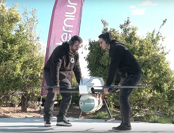
Screenshot: Quaternium video
Non-stop flight in Valencia
On Feb. 3, drone company Quaternium broke its own record for long flight time with a hybrid-fuel electric drone. The Quaternium HYBRiX UAV took off at 08:52 a.m. in Valencia, Spain, and landed at 17:02 p.m., after performing a stationary flight of 8 hours and 10 minutes. The new endurance record for non-stop flight time was accomplished with an experimental version of the company’s HYBRiX 2.1 drone, which carries 25 kilograms of maximum take-off weight.
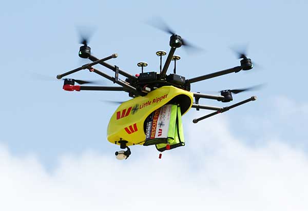
Westpac Little Ripper. (Photo: The Ripper Group/SLSA)
Dye-dropping drones
A company is providing drones that can drop sea- marker dye into ocean surf, allowing lifeguards on shore to spot riptides. The drones have been developed by The Ripper Group, reports the Brisbane Times. A fleet of 51 drones is being deployed across 25 beaches on the Gold and Sunshine coasts in Australia, as well as farther north. The drones also could be used to rapidly assess situations such as people swimming or climbing on rocks. Plus, the company has deployed drones to detect sharks and crocodiles.
Agricultural diseases cause significant crop losses worldwide. One widespread disease is yellow Sigatoka, which limits banana cultivation. Scientists at Brazil’s Federal University of Ceara have used high-resolution aerial images from an Inspire 1 UAV and machine learning to monitor yellow Sigatoka in banana crops, identifying and classifying disease symptoms such as leaf spots. The system also provides humidity and temperature data that can help assess and manage the disease.
Rescue from above
A blind man who spent 33 hours lost in February in the freezing Connecticut woods was rescued thanks to a police drone. Richard Doty, 62, was trapped in the woods near his Enfield home after he became disoriented, Enfield police said on Facebook. Temperatures had dipped as low as 9° F. Officers borrowed a drone and a skilled pilot from police in neighboring Vernon. Within 30 minutes of lift-off, the drone spotted Doty about 100 yards into the woods, hidden from view down an embankment.
A roundup of recent products in the GNSS and inertial positioning industry from the April 2020 issue of GPS World magazine.
OEM
LPWA module
Collaborative IoT solution
Photo: Quectel
Quectel Wireless Solutions’ LPWA module BG95 is being integrated with Microsoft’s Azure Device software development kit (SDK). The BG95 cellular module is based on the Qualcomm 9205 LTE modem. The integration will provide direct and secure connections to the Azure IoT Hub and provide full support for Azure device management. Customers can connect their BG95 devices to the Microsoft Azure cloud where they can build, manage and deploy internet of things (IoT) solutions at scale, significantly accelerating time to market. The BG95 module is a highly integrated variant supporting integrated GNSS, Cat M1, Cat NB2 and EGPRS (also called edge). The module complies with 3GPP Release 14 and delivers improved capabilities in power consumption, data rates and hardware-based security.
The SARA-R422 product series of LTE-M/NB-IoT and EGPRS cellular modules now include GNSS variants for internet of things (IoT) data, devices and ecosystems. The SARA-R422M8S module is pre-integrated with the u-blox M8 GNSS receiver and a separate GNSS antenna interface. This provides highly reliable, accurate positioning data simultaneously with LTE communications. The module also supports hybrid positioning strategies, in which positioning data provided by satellite constellations is enhanced with data from the u-blox CellLocate service, ensuring that location data is always available everywhere. The SARA-R4 series is designed for a wide range of mission-critical IoT solutions such as connected healthcare, industrial monitoring, point of sale and vending terminals, tracking and telematics devices, as well as smart lighting solutions and building automation.
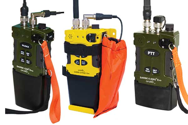
The new line of Sarbe search and rescue beacons. (Photo: Orolia)
Orolia has improved its Sarbe Evo search-and-rescue (SAR) beacon range line to deliver upgraded operational capabilities. The line offers new operational improvements to meet revised Cospas-Sarsat requirements in operating lifetime, location accuracy, voice signal management, integrated protocols, testability and maintenance. Also a focus of the upgrade was more robust and frequent GPS/GNSS position acquisition with the GPS, Galileo and GLONASS satellite constellations.
ADVA’s GNSS assurance solution could help companies dependent on satellite-based timing. (Photo: Business Wire)
ADVA’s GNSS assurance solution helps companies dependent on satellite-based timing. The centralized GNSS monitoring and assurance tool uses artificial intelligence and machine learning for comprehensive predictive maintenance. The customer-owned tool enables users to collect and analyze huge amounts of information from across the network to remotely identify issues and protect networks from GNSS vulnerabilities, including jamming and spoofing attacks. It also helps to identify GNSS obstruction issues, detect blind/poor spots that appear over time, and enable optimal antenna positioning. Built into ADVA’s Ensemble Controller network management suite with Sync Director, the solution enables customers to detect potential problems in advance and maintain the highest quality of network synchronization. It complements the limited distributed approach to GNSS assurance with a centralized global system, providing a boost to critical infrastructure now dependent on satellite-based timing.
The Locosys MC-1612-DG is a single-band multi-system with an ARM-based processor that supports GPS, GLONASS, Galileo, QZSS and SBAS. The embedded micro-electro-mechanical systems (MEMS) sensor is equipped with dead-reckoning software and provides six-axis accelerometer and gyroscope data. The extended Kalman filter algorithm combines GNSS and MEMS sensor data with a weighting function that relies on GNSS signal quality. In adverse GNSS conditions such as urban canyons, tunnels or parking garages, the dead-reckoning features boost accuracy with the software filling the gaps. It supports three-dimensional dead-reckoning and standard NMEA output, and has Flash memory, TCXO, RTC crystal, LNA and SAW filter.
The automotive-grade solid-state RS-LiDAR-M1 family has the performance advantages of traditional mechanical lidar, while meeting requirements for mass-produced vehicles. The RS-LiDAR-M1Smart is embedded with an artificial intelligence perception algorithm that transforms conventional 3D lidar sensors into a full data analysis and comprehension system, outputting semantic-level structured environment information in real time for autonomous vehicle decision making. The RS-LiDAR-M1Smart outputs two redundant channels of data: the original point cloud and the object list. The redundacy provides vehicles with a range of sensing results — dynamic, static, inside and outside the road. Also available is the RS-LiDAR-M1Simple.
The Vsx7 multi-frequency position and heading receiver is designed specifically for machine control and can be mounted by bolts or with magnets on heavy equipment. Paired with the Carlson A45 antennas, the Vsx7 features high-precision positioning in Athena RTK, Atlas L-band and SBAS and heading accuracy of up to .01 degrees. The whole Vsx7 system is designed to operate in harsh conditions from –40° F to +158° F. The Vsx7 is primarily used in the mining and construction industries, but can be used in similar industries with companion software, Carlson Grade. Field data can be collected and viewed in real time both at the machine with either the MC8 or MC10 control box as well as in the office with Carlson Command.
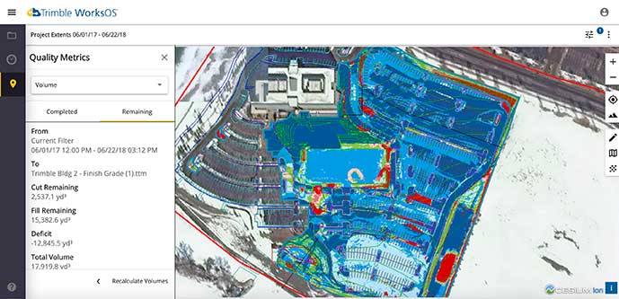
Trimble WorksOS is a new Software-as-a-Service (SaaS) operating system. The cloud-based system will integrate data from Trimble and third-party providers across the entire civil construction project lifecycle, including estimating, scheduling, designs and the field. Currently, site supervisors and project managers jump between multiple systems to keep track of daily production quantities, labor/equipment hours and equipment maintenance schedules. Works OS is designed to bring real-time visibility into jobsite progress, schedule and cost. Users will be able to log into a single application to view real-time visibility of cut, fill, volume and compaction data to maximize jobsite productivity. Site supervisors will see daily volume calculations and compaction quality metrics, and be able to monitor progress and schedules.
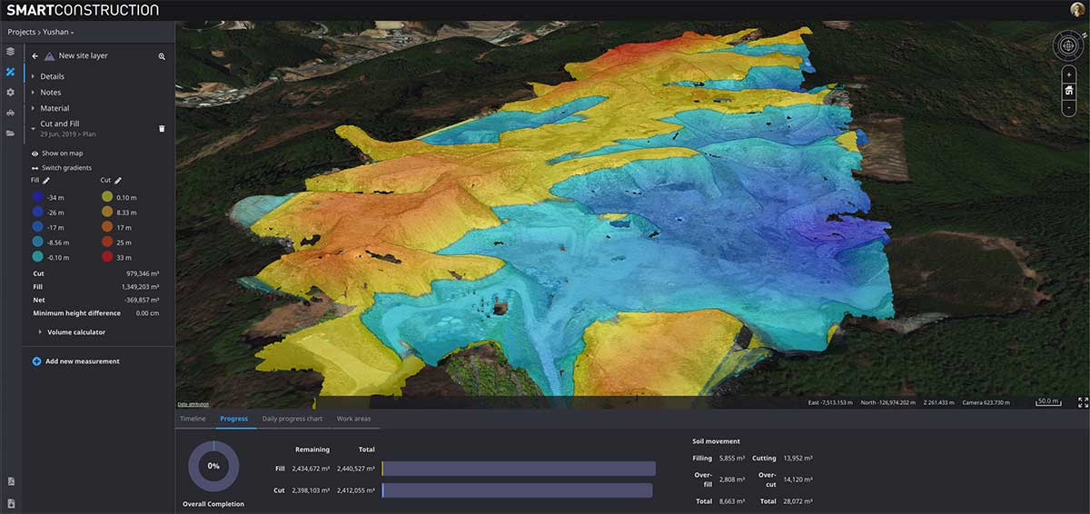
Komatsu’s Smart Construction dashboard includes the 3D visualization power and geospatial accuracy of Cesium, a platform to visualize, analyze and share 3D data. The dashboard enables users to monitor a construction site from anywhere in the world, see how it changes over time, and compare architectural plans with real-world data. It is compatible with data from sensors on construction machines, drone surveys, or computer-generated files like BIM/CAD models . It allows users to visualize projects in a single scene within a web browser, as well as calculate precise measurements for cut and fill, slope, contours and more.
Cesium, cesium.com
The TopoGrafi app has been updated to allow for display of 3D data in real-world models. With enhanced 3D data-processing capabilities, TopoGrafi is an end-to-end platform for capturing buried asset data and processing it for augmented reality visualizations. Designed to be used alongside apps such as Esri Collector for ArcGIS, the TopoGrafi platform uses GNSS data. It applies near-real-time conversions, transforming the recorded positions to local reference systems and aligning it with high-accuracy mapping including Ordnance Survey MasterMap. The TopoGrafi toolkit also includes functionality to snap 3D features to each other and to other spatially referenced data to create a 3D model that can then be used to create augmented reality visualizations accessible from the desktop or in the field.
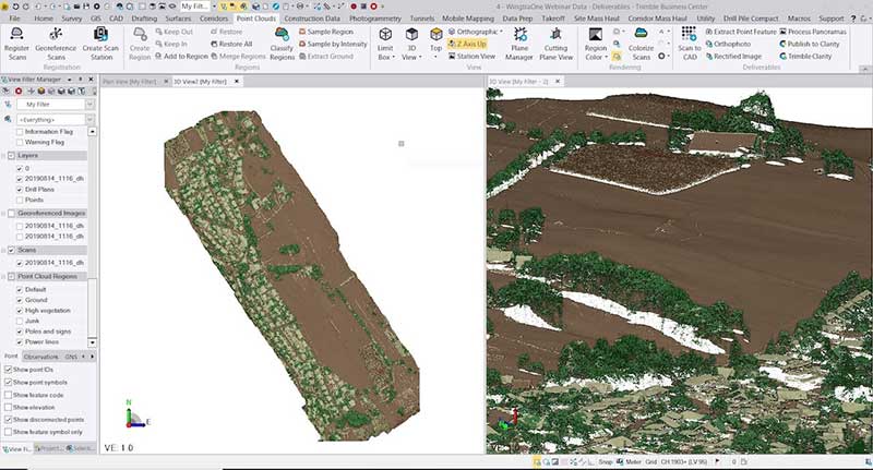
WingtraOne drone data can now be directly imported into the Trimble Business Center (TBC). The new integration combines WingtraOne high-accuracy drone data within TBC, optimizing drone mapping workflows for survey and construction projects within a single software platform. After dragging and dropping the JobXML data file, automated point cloud tools, such as classification and feature extraction, can quickly generate surface models, topographic plans and as-built deliverables. Also new: high-altitude flight capabilities, longer flight times and more intuitive battery-level readings in-flight.
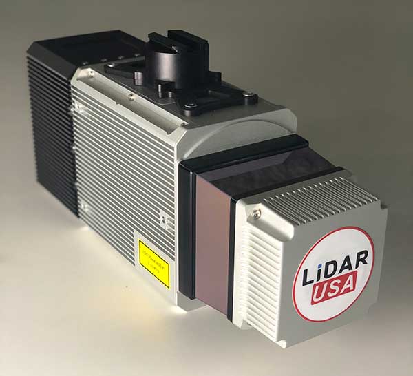
The Snoopy CL-360 lidar scanner. (Photo: Lidar USA)
The Snoopy CL-360 has been meticulously designed for integration on backpack, vehicle and UAV applications. Weighing 5 kilograms fully assembled, the Snoopy CL-360 is capable of delivering highly accurate results, up to +/-0.01 feet on paved surfaces from a vehicle. The system has a scan line rate of 250 Hz with a 500-kHz data rate, giving a uniform result along and across track. The system is easily configurable with multiple scanners (similar to internet of things applications) to avoid occlusions. A UAV deployment achieves scans with usable data as much as 60 degrees off nadir (widths of more than 1,100 feet while scanning at the 400-foot ceiling). The small beam size of 0.3 mrad allows the CL-series to reliably collect ground points (such as on or near the dirt through vegetation) while also providing better detection of fine linear features such as power lines and railroad tracks.
The E300 Pro receiver tracks GNSS with 700 channels and fully supports BDS-3 signals. It supports 31 frequency points, using all GNSS constellations and frequency bands. The E300 interface has a concealed design for better protection. USB type-C charging and transmitting is a two-in-one function. The magnesium-alloy body is rugged, and the battery level can be checked with a unique LED power indicator. The weight of the whole receiver is 940 grams. The E300 Pro supports satellite station differential and satellite chain life, quick connection, intelligent voice and tilt compensation. It integrates multiple sensors including GNSS, an inertial measurement unit (IMU), a magnetometer and a thermometer. With the help of a Kalman filter algorithm, the device can dynamically output position, speed and attitude information. It can measure and make real-time dynamic sampling without the need for leveling. For better radio signal quality, the E300 Pro integrates GNSS, Bluetooth, Wi-Fi, 4G main and auxiliary antennas on the top of the receiver to ensure the best reception in all directions. An RF connector improves connection reliability while reducing loss of gain.
The Nova MS60 MultiStation combines upgraded, fast 3D laser-scanning capabilities, GNSS connectivity and digital imaging with a high-end total station. It features a fast laser-scanning speed of up to 30,000 points per second, optimized scan area definitions, adapted scan managements, and an improved scanning path for zenith scans. Professionals can perform point-cloud analysis in the field. Scan data is combined with traditionally measured points from GNSS receivers to graphically show locations the same day it is collected.
CP Aeronautics, a new division of CP Technologies, has launched integrated turn-key solutions based on unmanned aerial systems (UAS) platforms, payloads, data links, ground control stations (GCS) and communications for defense and civil applications. The systems offer operationally proven solutions for intelligence, surveillance and reconnaissance (ISR) systems requirements. Its broad product portfolio has demonstrated excellent performance and operability in demanding environments, the company stated in a press release. Backed by continuous research and development, the systems are built on three decades of technological and operational experience. Systems include Orbiter 2 Small UAS, Orbiter 3 Small Tactical UAS, Orbiter 4 Small Tactical UAS (pictured), Aerostar Tactical UAS, Dominator XP (medium-altitude long-endurance) and Pegasus 120 (vertical takeoff and landing).
A new flight control system (FCS) fits and leverages multi-mission, multi-domain UAV platforms. Using the FCS, the new Saker-1B Medium Altitude Long Endurance (MALE) UAV performs with fully autonomous online and offline operation, from takeoff to landing. Testing included more than 500 hours of day and night test missions under various weather conditions, including extremes of dust and heat. A total of 1,000 hours of take-off and landing test missions were successfully performed, with long-endurance flights lasting up to 19 hours. The Saker-1B is equipped with a satellite communication data link for beyond-visual-line-of-sight (BVLOS) operation. The FCS provides sustainability to jamming attacks and advanced data security.
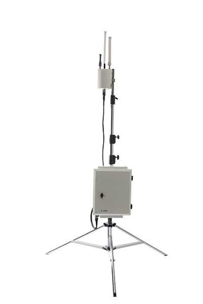
VigilAir is an RF-based system of deployed sensors able to accurately detect, geolocate and track commercial drones and their operators in different environments, including dense urban environments. VigilAir provides extremely sensitive detection and highly accurate geolocation and tracking over very large areas, with virtually zero false-alarms. Being a passive, receive-only system, VigilAir can easily be installed and operated without regulatory or legal limitations. The VigilAir version 2.0 C-UAS (counter unmanned aerial system) is certified by the United Kingdom Center for the Protection of National Infrastructure (CPNI) under the CPNI’s Counter Unmanned Aerial Systems Detect, Track and Identify (DTI) testing and evaluation standard. VigilAir generates a comprehensive drone situational awareness which enables users to proactively and intelligently match correct mitigation actions with actual drone threats, on time and with minimal collateral effects.
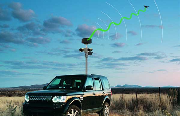
Xpeller Rapid — the mobile version of the counter UAV solution Xpeller — uses a combination of radar, electro-optical sensors, rangefinders and jammers to protect against threats posed by over-the-counter drones. Xpeller Rapid is either integrated into a vehicle (mast solution) or comes in transport boxes and can be easily set up on tripods. Based on the Xpeller toolkit, the components follow the detect, identify, control and act workflow, defeating hostile drones at ranges up to several kilometers. The system can locate and classify even small hobby drones at a range of several kilometers. High-resolution cameras make it possible to decide whether there is a serious threat so that it can be countered with appropriate countermeasures.
Draganfly Inc., a leading North American-based commercial drone company, is partnering with Windfall Geotek to develop drone-based solutions for landmine detection.
Windfall Geotek is a Quebec-based technology services company and a leader in the use of artificial intelligence (AI) and advanced knowledge-extraction techniques in the mining sector.
The companies will work to develop an artificial intelligence (AI) driven unmanned aerial systems solution for landmine detection in the defense, humanitarian and other sectors in which the companies have expertise.
While landmines have been used since World War I, their deployment proliferated from the 1960s onwards. To this day, many unexploded devices are killing and maiming people who step on or trigger the bombs unintentionally.
About 60 countries and territories are still contaminated with anti-personnel mines, and more than 120,000 people were killed or injured by landmines between 1999-2017, according to research by Landmine Monitor.
Terms of the agreement include joint research, development and engineering support, drones and equipment o further commercialize an AI driven drone solution for the detection and elimination of landmines, unexploded ordnance and.improvised explosive devices (IEDs).
In 2018, governments and nonprofits allocated nearly US$700 million in combined international
and national support for mine action in 2018. The economic impact of landmines is estimated at $100 billion.
“We have been evaluating drone solutions for nearly a year, and after an exhaustive analysis of the market and providers, it is exciting to select Draganfly as our first drone systems partner for this worthwhile initiative,” said Dinesh Kandanchatha, chairman of Windfall Geotek.
“Windfall Geotek is the industry leader in AI-based digital exploration for mining. When they approached us on this project, it seemed like a natural fit to partner our engineering and drone capabilities, with their proven software and AI expertise,” sid Cameron Chell, CEO, Draganfly. “The two companies share a mission of saving lives through technology. We expect this partnership to generate new and expanded revenue streams for both companies in the defense sector, public safety and other markets where both companies have expertise.”
Topcon Positioning Group is offering a new Thermal Mapper for asphalt paving. It is designed to monitor temperature segregation to prevent future problems and measure performance, as well as provide accurate compliance reporting — all with real-time kinematic (RTK) positioning accuracy.
The mapper records temperature readings behind an asphalt paver as the paving is in progress and provides a visualization to operators in real time of whether the mix falls within a predefined temperature range, and if any segregation is limited within specifications.
“If too much segregation occurs, roads will soon develop major problems. The mapper quickly tells operators if the mix is stable or if moderate or severe temperature variation is occurring. If the readings are unacceptable, operators can adjust for more efficient and accurate project outcomes,” said Murray Lodge, senior VP of construction. “The system’s sensors also bring to the market the first thermal mapping system with RTK GPS positioning for more accurate results than conventional methods.”
The system also creates data reporting files to download for applications such as U.S. Department of Energy compliance through an interactive Pavelink module, the Topcon cloud-based logistics application for asphalt paving.
“We are excited about where Topcon is taking the paving industry with the different solutions we are bringing to market. From SmoothRide, where we scan the existing road to determine the optimal design for variable depth milling and paving to the newly released Pavelink system, we are focused on improving paving.
“Pavelink allows contractors to monitor the entire paving workflow from the batch plant, mixing plant, trucks, to the paver, to the rollers. By connecting the entire process, it allows the contractor to have full control over their projects in real time and make adjustments along the way, instead of after the fact as is so often done with conventional methods. Now, bringing in the heat sensor system into that workflow, we are giving contractors more resources to meet the specifications demanded today.
“It is part of our commitment to revolutionize the planning and management of the asphalt paving process with real-time visibility throughout the project lifecycle,” Lodge said.
In moves sure to concern privacy advocates, 19 countries are now accessing citizens’ mobile location data in an effort to fight the coronavirus outbreak.
A COVID-19 Digital Rights Tracker by Top10VPN lists countries that are using mobile data for the pandemic. Uses range from anonymous aggregated data to monitor the general movement of people, to tracking the phones of individual coronavirus patients, to tracking suspected patients and their contacts, known as “contact tracing.”
“In the past week we have witnessed a 90% growth in the number of countries implementing digital tracking measures and a 100% increase in reports of censorship,” reported Top10VPN on March 26.
In the United States, the Senate’s $2 trillion economic stimulus bill includes $500 million for the Centers for Disease Control (CDC) to launch a new “surveillance and data-collection system” to monitor the spread of COVID-19, reports Business Insider.
Europe’s telecom companies are sharing location data with health authorities in Italy, Germany and Austria, according to Reuters, to check whether people are remaining at home. The data is aggregated and anonymous, mapping concentrations rather than individuals to respect Europe’s privacy laws.
In South Korea, the government created a map of cellphone data provided by telecom and credit card companies. The map was made public so everyone could track whether they’d been exposed, according to The Verge.
According to reports, Iran used the COVID-19 epidemic to gather private data from its citizens “to boost Tehran’s surveillance capabilities,” reports Vice. The country sent a link to download the AC19 app with government endorsement, touting it as a way to determine whether users have the virus, but usage required sending back location data.
In Taiwan, a mobile phone-based geo-fence uses location-tracking to ensure people who are quarantined stay in their homes, reports the New York Times. If the patient leaves their home address or turns off their smartphone, the police will visit within 15 minutes.
SafePaths app
The new Private Kit: SafePaths app, developed by Massachusetts Institute of Technology (MIT) researchers, is now available, though it is still under development. The downloadable app (for IOS and Android 8.0 and above) informs users if they’ve crossed paths with coronavirus patients, known through published data.
“The solution is a ‘pull’ model where users can download encrypted location information about carriers so the users can self-determine their likely exposure to COVID-19 and coordinate their response with their doctor using their symptoms and personal health history,” according to a white paper about the contact-tracing app.
The app takes privacy into consideration — COVID-19 patients consent to provide health officials with an accurate location trail once they are diagnosed. “Governments are equipped with a tool to redact location trails and thus broadcast location information with privacy protection for diagnosed carriers and local businesses,” the white paper reads.
“Since the outbreak of COVID-19, governments around the world have implemented a range of digital tracking, physical surveillance and censorship measures in a bid to slow the spread of the virus,” warns Top10VPN. “Some of these may well be proportionate, necessary and legitimate during these unprecedented times. However, others have been rushed through legislative bodies and implemented without adequate scrutiny.”
IMO is the United Nations body that coordinates and sets standards for international maritime operations and safety.
In a paper dated March 10, the service said that GNSS signals are “essential to safe and efficient navigation and an integral component of all maritime operations.” Interfering with them “jeopardizes the safety of life at sea.”
Deliberate disruptions in the eastern Mediterranean and the Black Sea, the paper says, affect vessels operating in international waters and engaged in innocent passage through territorial seas.
While nations typically have a right to do as they wish in their sovereign territory, they are also obliged to not have that intrude into other nations’ territory or international waters. This is also true for vessels passing through their waters but not calling at their ports, known as “innocent passage.”
The International Law of the Sea Treaty stipulates that, in the absence of some clear wrongdoing such as piracy, drug smuggling or discharging oil, vessels be allowed to pass through territorial seas unmolested by the coastal state.
The Coast Guard paper also points out that nations have other treaty obligations that prohibit this kind of activity. International Telecommunication Union Radio Regulations prohibits “All transmissions with false or misleading identification…”
Citing a March 2019 report in GPS World, the paper also documents that GNSS disruption is a global problem not confined to just one or two areas. A study by the German Aerospace Center (DLR) found interference during every phase of a vessel’s voyage between Europe and the Far East.
The Coast Guard paper was submitted for consideration at IMO’s Maritime Safety Committee that had been scheduled to meet on May 13, but has been postponed due to the COVID-19 emergency.
This planned consideration at IMO follows a resolution by the UN’s International Civil Aviation Organization (ICAO) in May 2019. In a paper entitled “An Urgent Need to Address Harmful Interferences to GNSS,” the International Federation of Air Traffic Controllers’ Association (IFATCA), the International Federation of Air Line Pilots’ Associations (IFALPA), and the International Air Transport Association (IATA) had introduced the issue.
This resulted in a resolution describing the eliminating interference as an urgent need.
About the same time the U.S .Coast Guard paper was due to be considered, IMO was to engage in the early stages of considering rules for autonomous vessels. Its Facilitation Committee was scheduled hold a “Regulatory scoping exercise for the use of Maritime Autonomous Surface Ships (MASS)” at a meeting the end of April. This meeting has also been postponed.
While not specifically mentioned, navigation issues will undoubtedly be part of the considerations when discussion of rules for autonomous shipping eventually takes place.
Public input to these international meetings is always sought in advance. For example, the U.S. State Department had announced a meeting for April 6 to receive public input on U.S. positions for the various issues to be discussed at the Facilitation Committee.
While we understand that this meeting will also be also be postponed, comments can be submitted to the points of contact listed in the Federal Register announcement as well as be raised during the eventual meeting.
The American Transportation Research Institute released data showing that trucks are continuing to move — in many cases faster than usual — to respond to the demands placed on the industry by the COVID-19 pandemic.
“ATRI’s real-time GPS data comes from more than a million trucks, allowing us to analyze freight flows, and so far in March, what we are seeing is an unprecedented level of truck movement,” said ATRI President and COO Rebecca Brewster. “Not only are trucks continuing to move, but they are doing so at speeds well in excess of normal traffic patterns.”
For example, according to ATRI’s data, at the intersection of I-85 and I-285 in Atlanta, known locally as Spaghetti Junction, afternoon rush hour truck speeds are typically less than 15 MPH due to congestion. Last week, truck speeds averaged 53 MPH.
“Spaghetti Junction is typical of what we’ve seen across the country, especially in areas hit hard by the virus and subject to quarantines and lockdowns,” Brewster said. “As other traffic dissipates, trucks continue to move, delivering much-needed relief supplies to markets, hospitals, gas stations and other essential businesses.”
Among the hardest hit states, New York, California and Illinois, the data is showing similar changes.
In New York, along I-495 in Queens, the afternoon rush hour typically sees average truck speeds of 16 MPH. Speeds have now more than doubled, averaging 38 MPH, still below the posted speed limit but certainly an improvement.
In Los Angeles, at the intersection of I-710 and I-105, truck speeds during highly congested morning rush hours are normally less than 25 MPH between the hours of 6 and 8 a.m. Truck speeds are now averaging 53 MPH in the morning as Californians stay home but truck deliveries increase.
At the Byrne Interchange in Chicago, where I-290 intersects with I-90/I-94, morning truck speeds are now averaging 43 MPH, more than twice the typical morning rush hour speed of 20 MPH.
According to ATRI’s analysis, the results can be explained by several COVID-19 related factors:
The dramatic reduction in commuter traffic allows trucks to operate at higher speeds, particularly during traditional rush hours.
Continuous 24/7 truck operations generate higher average truck speeds across nearly all hours of the day.
ATRI’s analysis used truck GPS data from more than a million heavy-duty trucks and the locations examined included some of the nation’s top truck choke points.
“Normally, ATRI’s bottleneck data is used to show us where the problems are on our highway system,” said American Trucking Associations President and CEO Chris Spear, “but during this period of extreme uncertainty, the data is showing us where the solution is — in the back of America’s trucks as professional drivers continue to quickly and safely deliver life-sustaining medical supplies, food, fuel and other essentials to Americans when they need it most.”
ATRI is the trucking industry’s 501c3 not-for-profit research organization. It is engaged in critical research relating to freight transportation’s essential role in maintaining a safe, secure and efficient transportation system.
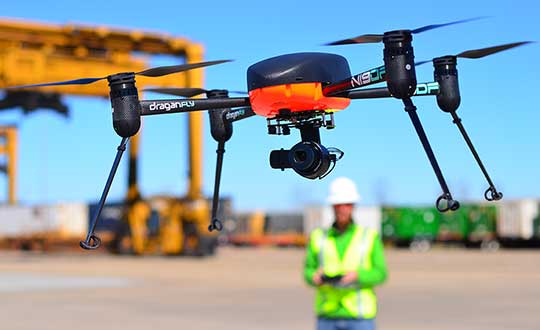
Draganfly will integrate a breakthrough health diagnosis onto cameras and UAVs to combat coronavirus.
In a rush to combat the global spread of the deadly coronavirus (COVID-19) in the U.S., Draganfly will deploy “pandemic drones” to remotely monitor and detect people with infectious and respiratory conditions to help stop the spread of the disease.
The Draganfly drones will be fitted with a specialized sensor and computer vision system that can monitor temperature, heart and respiratory rates, as well as detect people sneezing and coughing in crowds and other places where groups of people may work or congregate.
Draganfly will serve as the global systems integrator for the Vital Intelligence Project, a health and respiratory monitoring platform from Vital Intelligence Inc. The breakthrough technology was developed in a collaboration between the University of South Australia and the Science and Technology Group (DST), which is part of Australia’s Defence Department.
Coughing detected
The sensing system uses existing and new camera networks, UAVs and remotely piloted aircraft systems for health monitoring and detection of infectious and respiratory conditions — including monitoring temperatures, heart rates and respiratory rates.
The drones can monitor people in public crowds, workforces, airlines, cruise ships, convention centers, border crossings or critical infrastructure facilities. The technology can also be used to monitor potential at-risk groups, such as seniors in care facilities.
The Draganfly demonstration video below shows the camera detecting not only temperature, heart rate and respiration, but when a person is coughing.
Draganfly Video
Under the exclusive contract, initially budgeted at $1.5 million, Draganfly will use its engineering, integration and distribution expertise as well as its secure supply chain for immediate commercialization and deployment of the technology.
“The university and Defence supported my team’s efforts to develop automation for use in epidemics and disasters,” said Javaan Chahl, Defence Science and Technology Chair at the University of South Australia. “We had imagined the technology being used in a future relief expedition to some far-away place. Now, shockingly, we see a need for its use in our everyday lives immediately. Draganfly’s industrial know-how is quickly helping us ensure our research can save lives.”
The Draganflyer Commander UAV is a remotely operated miniature helicopter designed to carry wireless camera systems. (Photo: Draganfly)
“Draganfly has been selected because of its proven leadership in an industry so important to public safety at such a critical time. We look forward to working with global agencies and industry to rapidly deploy this important technology,” said Cameron Chell, Draganfly CEO.
“Draganfly is honored to work on such an important project given the current pandemic facing the world with COVID-19,” said Andy Card, Draganfly director and former U.S. Secretary of Transportation and White House chief of staff. “Health and respiratory monitoring will be vital for not only detection, but also utilizing the data to understand health trends. As we move forward, drones and autonomous technology doing detection will be an important part of ensuring public safety.”
“With fighting epidemics rising as a global priority, new versatile technologies, such as humanitarian mission UAVs, are immediately needed to detect and track outbreaks so that critical interventions can be deployed sooner and with greater effectiveness,” said Jack Chow, advisor to the Vital Intelligence Project. Chow is a former first assistant director-general on infectious diseases for the World Health Organization (WHO).
Smart speakers such as the Amazon Alexa or Google Home haven’t mastered determining user location in the home. Solving this problem was the focus of a University of Illinois at Urbana-Champaign research team’s recently published paper.
The team — led by Coordinated Science Lab graduate student Sheng Shen — explores the development of VoLoc, a system that uses the microphone array on Alexa as well as room echoes of the human voice to infer user location inside the home.
If applied, after receiving commands such as “turn on the light” or “increase the temperature,” Alexa would know which light and room is intended. Using a technique known as reverse triangulation, Shen and advisor Romit Roy Choudhury are getting closer to voice localization.
“Applying this technique to smart speakers entails quite a few challenges,” Shen said. “First, we must separate the direct human voice and each of the room echoes from the microphone recording. Then, we must accurately compute the direction for each of these echoes. Both challenges are difficult because the microphones simply record a mixture of all the sounds altogether.”
VoLoc addresses these obstacles through an align-and-cancel algorithm that iteratively isolates the direction of each arriving voice signal, and from them, reverse triangulates the user’s location. Some aspects of the room’s geometry is spontaneously learned, which helps with the triangulation.
While this is an important breakthrough, Shen and Roy Choudhury plan to expand the research to more applications. “Our immediate next step is to build to the smart speaker’s frame of reference,” Shen said. “This could mean superimposing the locations, as provided by VoLoc, on a floorplan to determine that the user is in the laundry room. Alternatively, if the smart speaker picks up the sounds made by the washer and dryer in the same location as the voice command, it can come to the same conclusion.”
Citation. S. Shen, R. Choudhury et al., “Voice Localization Using Nearby Wall Reflections,” to be presented at MobiCom 2020: 26th Annual International Conference on Mobile Computing and Networking, Sept. 21–25, London, UK.
Photo: Michael Wapp/iStock Editorial / Getty Images Plus/Getty Images