Organizers stated, “In light of the current situation caused by the coronavirus as well as related travel restrictions and resulting cancellations we unfortunately are forced to cancel the Munich Satellite Navigation Summit 2020 as we are no longer able to provide a well-ordered and appropriate program.”
Those who were attending are asked to be patient as the event organizers proceed to “sort out all necessary administrative issues.”
The summit brings together experts in industry and government; this year, it was go take place in Alte Kongresshalle, Munich, Germany.
Attendees are also told it may be possible to transfer their registration to the 2021 conference.
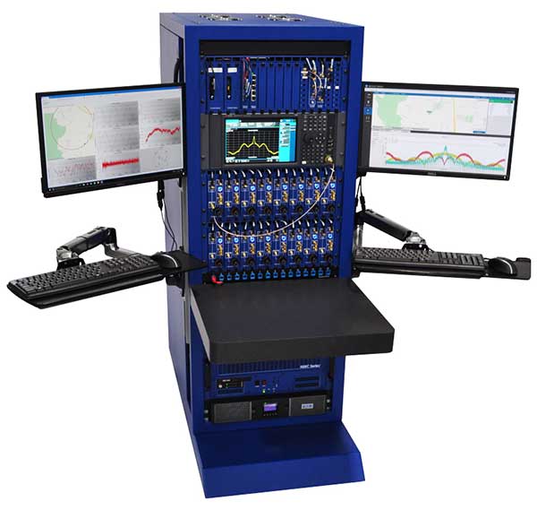
The CAST-5000 produces a coherent wavefront of GPS RF signals to provide repeatable testing in the laboratory environment or anechoic chamber. The basic system generates four independent, coherent simulations that reference a single point and is configurable to support up to eight elements for CRPA testing. With an intercard carrier-phase error of less than 1 millimeter, the CAST-5000 is extremely accurate.
The system generates a wavefront of GPS when its GPS RF generator cards are operated in a ganged configuration. Each generator card provides a set of GPS satellites coherent with the overall configuration. Several RF generator cards may be utilized together, ensuring phase coherence among the bank of signal generator cards. The CRPA antenna, antenna electronics and the GPS receiver can be tested as a unit with or without radiating signals.
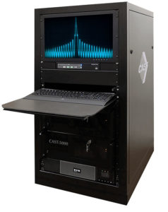
The CAST-8000 is a new simulator that merges the CAST-5000 CRPA tester with a CAST-3000 EGI tester. The CAST-5000/8000 has the ability to be “ganged” together with additional CAST simulators to provide multiple vehicle and/or multiple antenna test configurations.
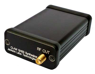
The 18-channel miniature full-constellation CLAW GPS Simulator is a fully self-contained, low size, weight, power and cost (SWaP-C) miniature GPS simulator. It is very popular in manufacturing environments as well as R&D applications that require consistent and repeatable local GNSS signals at low price points.The CLAW simulator does not require external computers for processing and control — it works fully self-contained by simply applying power, and storing location/time/date data in internal non-volatile (NV) memory, or by storing complex vector data to simulate highly dynamic scenarios. The CLAW also can be used to transcode NMEA or SCPI position/velocity/time (PVT) data into GPS RF signals. JLT offers an easy to use, highly configurable and cost-free SimCon Windows application program that is downloadable from the JLT website.
The SimConapplication allows random scenario generation and is thus usable to simulate leap-second events, week 1023 rollover events, or any other GPS live-sky scenarios including highly complex yet easy-to-create dynamic vector simulations. For authorized U.S. government users, a version that does not have altitude and velocity limitations is popular for low-Earth-orbit (LEO) simulations. Multipath simulation allows use of the entire 18-channel simulator capability. The unit can be field-upgraded with an easy to use in-field software upgrade feature. The CLAW is also very useful in GNSS receiver sensitivity testing for R&D or mass-production assembly lines as it allows accurate control of RF output power ranging from –100 dBm to less than –130 dBm with 0.1-dB resolution and typically better than 1-dB accuracy over the controllable power range.
The CLAW GPS Simulator also has a built-in RF signal generator with sweep, CW and random noise functions that are useful in simulating GNSS jamming scenarios, as well as GPS spoofing scenarios. The simulator comes in an FCC-certified metal desktop enclosure with numerous accessories.
The Orolia family of GNSS simulators offers a wide breadth and depth of tools for those responsible for mission-critical positioning, navigation and timing (PNT) applications. The simulation tools enable users to test a variety of scenarios, from simple to complex. Orolia’s simulators are feature-rich and easy to use, offering a way to harden GPS/GNSS-based systems without the limitations of testing from live-sky signals. Orolia’s approach allows users to buy only what they need today and upgrade later.
ESSENTIAL
Photo: Orolia
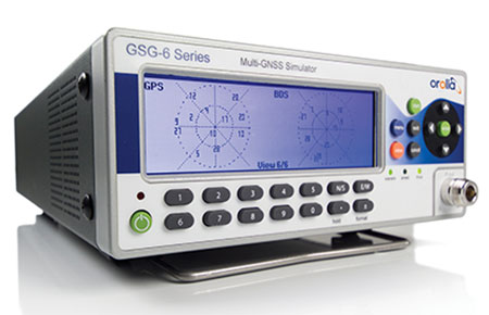
GSG 5/6. An essential scenario-based simulator used for testing a variety of smart applications such as drones, the internet of things (IoT), connected cars, cellular and more. GSG 5/6 offers ease-of-use with an out-of-the-box configuration and comprehensive set of pre-defined scenarios, plus the ability to create scenarios. It can simulate all constellations, all frequencies, and movements/trajectories anywhere on or above Earth. This enables a multitude of test solutions covering accuracies and sensitivities due to environmental conditions, technology factors and other events. Application packages are available for real-time kinematic (RTK), eCall, high-velocity, jamming and sensors.
ADVANCED
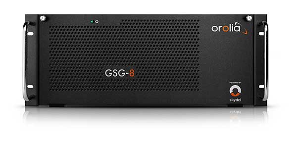
Skydel Software Engine. The software behind Orolia’s high-end GNSS simulators: GSG-8, BroadSim, BroadSim Anechoic and BroadSim Wavefront. All share the same software-defined benefits and interoperability. In addition to Orolia’s turn-key systems, Skydel can run on the user’s own commercial off-the-shelf (COTS) hardware. It is suitable to test and validate GNSS systems for a variety of applications, with advanced signal customization and configurable outputs. Users can create advanced scenarios with multiple parameters and variables: antenna patterns, orbits, multipath, hardware-in-the-loop (HIL) and more. The easy-to-use API configures all aspects, available in Python, C#, C++ and LabVIEW. User interactions can be recorded and exported as executable Python script — a learning tool that drastically reduces the automation learning curve.
Photo: Orolia
GSG-8. An advanced software-defined GNSS simulator supporting multiple constellations, frequencies and hundreds of signals all-in-view. With a 1000-Hz iteration rate, high dynamics and real-time synchronization, GSG-8 delivers ultra-high performance and flexibility. It is designed for space trajectories, custom PNT signals, HIL and more. Advanced jamming and spoofing options allow users to create benign and threat scenarios required for critical applications. Complex objects such as Differential GNSS (RTK), multi-antenna vehicles, attitude measurements and sophisticated GNSS receivers can be tested. A comprehensive software development kit (SDK) allows users to incorporate encrypted or proprietary signals. Powered by the Skydel Simulation Engine.
Photo: Orolia
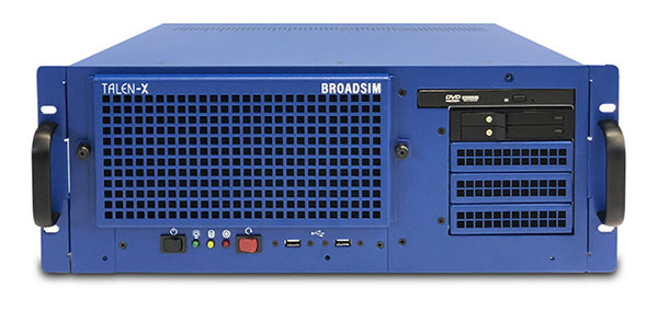
BroadSim. Available through Orolia Defense & Security, BroadSim was designed to meet the demand of NAVWAR testing. BroadSim supports high dynamics, advanced jamming and spoofing simulation tools, and encrypted military codes including Y-code, M-AES and M-MNSA. BroadSim uses a custom Linux operating system for security and better performance. BroadSim excels in NAVWAR applications due to its four independent RF outputs, a wide dynamic range with up to 0 dBm transmit power, and integrated jamming and spoofing scenario creation. BroadSim’s ease-of-use and functionality to configure multiple vehicles allows any user to seamlessly test the performance and vulnerability of their system without requiring a high level of expertise. Powered by the Skydel Simulation Engine.
Photo: Orolia
BroadSim Anechoic. Available through Orolia Defense & Security, BroadSim Anechoic enables users to accurately simulate over-the-air (OTA) GNSS environments in their anechoic chamber. Designed from the ground up for the user, by users, the system has 32 individual RF outputs enabling it to drive 16 dual-frequency antennas. The automation of antenna mapping, time delay and power loss calibration cuts set-up time from days to minutes. Easily verify signals with a built-in spectrum analyzer. The 48-dB transmit chain amplifier and 80-dB transmit chain dial attenuator allow for complete signal control and high dynamic range. Powered by the Skydel Simulation Engine.
Photo: Orolia
BroadSim Wavefront. Available through Orolia Defense & Security, BroadSim Wavefront enables fully featured testing of controlled reception pattern antenna (CRPA) and multi-element antenna electronic systems. Scaled upon the same easy-to-use software-defined platform and interface, it supports 4-16 antenna elements with integrated high dynamics and a phase coherence of 1° σ. Users can simultaneously simulate multiple spoofers, jammers, repeaters and alternate PNT sensors with just a few clicks. The Wavefront makes no compromise between the number of signals and the iteration rate, which remains at 1,000 Hz. It is designed to help engineers deliver results and make decisions, and can be calibrated in a matter of minutes. Powered by the Skydel Simulation Engine.
The LabSat 3 Wideband is a compact yet powerful multi-constellation and multi-frequency GNSS testing solution.
The easy-to-use, one-touch record and replay function provides an efficient way to test and develop GNSS-based technology without the cost and limitations of live-sky signals.
With simple-to-install upgrade options available, customers can invest with the confidence that its capabilities can grow alongside their future requirements.
LabSat 3 Wideband can record and replay up to three different channels at 56-MHz bandwidth across all major constellations and signals including:
GPS: L1/L2/L5
GLONASS: L1/L2/L3
BeiDou: B1/B2/B3
QZSS: L1/L2/L5
Galileo: E1/E1a/E5a/E5b/E6
L-band correction services including SBAS and IRNSS
2x CAN, RS232 and digital inputs tightly synchronized with GNSS data
Future signal launches are also supported, including L2C, L5 and L1C
LabSat 3 Wideband has a removable SSD (up to 7TB) and a two-hour runtime provided by an internal battery. It is lightweight and portable, making it ideal for field testing in any environment.
SatGen Signal Simulation Software
SatGen software allows users to quickly create bespoke, accurate scenarios with their own time, location and trajectory, that can be replayed via a LabSat GNSS Simulator.
The latest version of SatGen can be used to create a single scenario containing all the upper and lower L-Band signals for GPS, Galileo, GLONASS and BeiDou.
Precision-sensitive applications such as autonomous driving, control of unmanned aerial vehicles (UAV), or positioning of aircraft during landing procedures in coordination with ground-based augmentation systems (GBAS) require that modern GNSS receivers undergo detailed tests before implementation.
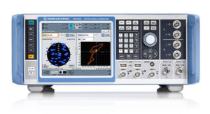
Rohde & Schwarz signal generators like the R&S SMW200A and the R&S SMBV100B offer a unique approach to generating complex and highly realistic scenarios for testing of GNSS receivers that are able to work with diverse navigational systems such as GPS, GLONASS, Galileo, BeiDou and QZSS/SBAS signals. Both simulators can emulate them all for testing.
R&S SMW200A. The R&S SMW200A GNSS simulator (pictured above) can be used to produce complex interference scenarios with multiple interferers — all generated within the instrument itself. It can emulate up to 144 GNSS channels and can be equipped with up to four RF outputs. With its ability to simulate multi-constellation, multi-frequency, multi-antenna and multi-vehicle scenarios, the R&S SMW200A is able to cover a variety of high-end GNSS applications.
R&S SMBV100B. The R&S SMBV100B supports the same navigational systems, with access to 60 GNSS channels and one RF output, with the same ability to configure realistic scenarios including obscuration, multipath and atmospheric effects, as well as the specific characteristics of the antenna and the simulated vehicle. An integrated noise and CW interference generator also can be added.
Since the devices do not require an external PC for scenario configuration, all the tests can be created quickly through the user-friendly GUI. Due to all-encompassing instrument options available, both simulators can be set up to fit unique user requirements.
For testing GNSS receivers under controlled and repeatable conditions, the R&S SMW200A and the R&S SMBV100B provide extensive and cost-effective solutions. The platforms are ready to adapt to future requirements and testing of newly implemented GNSS signals.
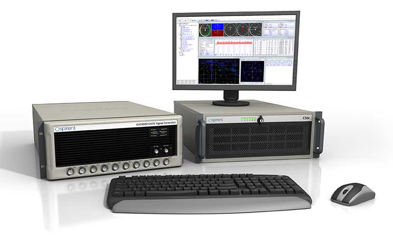
GSS9000, SimMNSA, CRPA test system, anechoic chamber testing, mid-range testing
Photo: Spirent Federal
Spirent Federal provides GPS/GNSS test equipment that covers all applications, including research and development, integration/verification and production testing.
GSS9000. The enhanced GSS9000 Multi-Frequency, Multi-GNSS RF Constellation Simulator is Spirent’s most comprehensive simulation solution. It can simulate signals from all GNSS and regional navigation systems and has a system iteration rate (SIR) of 1000 Hz (1 ms), enabling higher dynamic simulations with more accuracy and fidelity. The GSS9000 supports restricted/classified signals. Users can evaluate the resilience of navigation systems to interference and spoofing attacks, and have the flexibility to reconfigure constellations, channels, and frequencies between test runs or test cases.
SimMNSA. The first fully approved MNSA M-code simulator. Authorized users of the GSS9000 series of simulators will be able to utilize the advanced capabilities of SimMNSA to create more robust solutions for their customers. SimMNSA has been granted Security Approval by the Global Positioning System Directorate.
CRPA Test System. Spirent’s Controlled Reception Pattern Antenna (CRPA) Test System generates both GNSS and interference signals. Users can control multiple antenna elements. Null-steering and space/time adaptive CRPA testing are both supported by this comprehensive approach.
Anechoic Chamber Testing. Spirent’s GSS9790 Multi-Output, Multi-GNSS RF Constellation Wave-Front Simulator System is a development of the GSS9000. The GSS9790 is a unique solution providing the core element for GNSS applications that require a test system that can be used in both conducted (lab) and radiated (chamber) conditions.
Mid-Range Solutions. Spirent also offers solutions that cater to intermediate GPS/GNSS testing needs. The GSS7000 multi-constellation simulator provides an easy-to-use solution for GNSS testing that can grow with users’ requirements. The GSS6450 RF record and playback system enables replay of a real-world GNSS/GPS test repeatedly in the lab.
High-end GNSS simulation solutions for R&D, integration and production testing
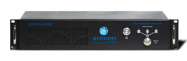
Photo: Syntony GNSS
Constellator. Syntony’s GNSS simulator Constellator supports all constellation signals available and provides a high level of service in different ranges. It covers, in a single unit, a wide spectrum of use cases from entry-level with L1C/A up to very demanding configurations such as multi-frequencies and 400 channels management.
Extensively used in aeronautics, space and defense industries, Constellator answers complex requirements:
Standalone mode (on the ground and in space)
Multi-frequencies
All constellations and their signals, including NavIC/IRNSS
Hardware in-the-loop (HIL) mode with zero-effective latency and 1000-Hz update rate
All typical synchronization interfaces
Particularly in the space industry, Constellator implements the advanced models (Earth gravity, drag, 3D ionospheric models, side lobes, etc.) needed to achieve accurate simulations for all kinds of orbits (from LEO to GEO and SSTO). Combined with other Syntony GNSS simulation products (interference generator, Recorder & Player Echo, GBAS simulator, etc.), Constellator can be used to tackle challenging use cases such as jamming, spoofing, multipath, and multiple antennas testing. Constellator is based on a software-defined radio (SDR), making it hardware-ready for future constellations, signals and codes. It is easily upgradeable and versatile.
GNSS Recorder & Player. Syntony’s Echo is an ultra-high-fidelity GNSS recording and playback solution. It is designed to capture real-life signals and environments, for instance from airplanes, and then replayed for R&D or production tests. Echo offers:
3 RF channels of 100-MHz bandwidth each (for the whole set of GNSS signals from all constellations)
16-bit resolution (I&Q)
from 7 to more than 1,000 hours of record/replay capabilities depending on configuration
Echo-R can also record complex and very long realistic scenarios from a simulator; Echo-P can replay them with very high fidelity for long-run or production tests. Please ask Chief Sales Officer Francois Goudenove for distributor contacts in the U.S., Europe, India, China, South Korea and Japan.
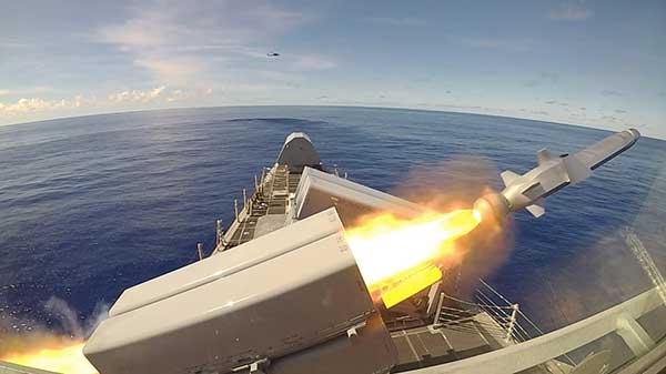
The Naval Strike Missile is a GPS-guided long-range, precision strike weapon that can find and destroy enemy ships at distances up to 100 nautical miles. The stealthy missile flies at sea-skimming altitude, has terrain-following capability (it banks to turn) and uses an imaging infrared seeker for precise targeting in challenging conditions. The missile employs a semi-armor-piercing warhead optimized for anti-surface warfare.
According to Raytheon, the missile also is suited for land attack missions because it can climb and descend with the terrain. It was successfully tested in a land-based mobile launcher configuration in 2018 as part of a multination military exercise. In 2019, the U.S. Marine Corps integrated a land-based Naval Strike Missile into its force structure, sharing costs and interoperability with the Navy.
The missile was first fired in the Indo-Pacific region, according to the Navy. Then, on Oct. 1, it was launched from the USS Gabrielle Giffords (LCS 10) during Pacific Griffin, an exercise conducted with the Singaporean navy near Guam Sep. 27 through Oct. 10, 2019.
The OTH-WS program is a long-range, surface-to-surface warfare system intended to offensively engage maritime targets both inside and beyond the radar horizon. The system consists of an operator interface console, Naval Strike Missile, and the Missile Launching System. The OTH-WS is intended to be a stand-alone system requiring minimal integration into the ship’s platform.
The Navy selected the Naval Strike Missile in 2018, with Raytheon as the contractor for its over-the-horizon defense of littoral combat ships and future frigates.
Also in 2019, the Navy conducted a structural test firing of the OTH-WS to assess the integrity and safety of the weapon system installation on the launch platform. The test showed there were no problems regarding integration of the missile launching system with the platform.
The Navy is planning to conduct Initial Operational Test and Evaluation and Live-Fire Test and Evaluation in fiscal years 2020-2022. and is developing a test and evaluation plan and live-fire test strategy.
The USS Gabrielle Giffords launches a Naval Strike Missile during exercise Pacific Griffin. (Photo: U.S. Navy//Chief Mass Communication Specialist Shannon Renfroe/Released.)
NASA is partnering with the New Zealand Ministry of Business, Innovation and Employment, New Zealand Space Agency, Air New Zealand and the University of Auckland to install next-generation GNSS reflectometry receivers on passenger aircraft to collect environmental science data over New Zealand.
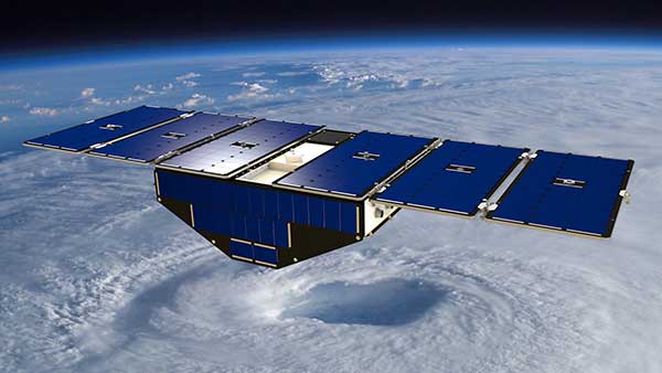
The program is part of NASA’s Cyclone Global Navigation Satellite System (CYGNSS) mission, a constellation of eight small satellites launched in 2016 that use GPS satellite signals that reflect off Earth’s surface to collect science data.
The CYGNSS satellites orbit above the tropics and their primary mission is to use GPS signals to measure wind speed over the ocean by examining GPS signal reflections off choppy versus calm water. This allows researchers to gain new insight into wind speed over the ocean and will allow them to better understand hurricanes and tropical cyclones.
Measurements over land
In addition to its primary over-water research capabilities, scientists have discovered that the CYGNSS technology is also capable of collecting valuable measurements over land, including of soil moisture, flooding, and wetland and coastal environments.
“Partnering with New Zealand offers NASA and the CYGNSS team a unique opportunity to develop these secondary capabilities over land. Taken together over time, they’ll also have an important story to tell about the long-term impacts of climate change to these landscapes,” said Gail Skofronick-Jackson, CYGNSS program scientist at NASA Headquarters, Washington.
The CYGNSS team, led by principal investigator Chris Ruf at the University of Michigan in Ann Arbor, has developed a next-generation GNSS reflectivity receiver with support from NASA’s Earth Science Technology Office. These receivers will be installed in late 2020 on one of Air New Zealand’s Q300 domestic aircraft.
Artist’s concept of one of the eight CYGNSS satellites in orbit. (Image: NASA/University of Michigan)
Aircraft overlap satellite path
As the aircraft traverses New Zealand, it will collect data from the land below, some of which will overlap with the flight paths of the CYGNSS satellites.
This overlap, which will have frequent data observations from regular commercial flights, will provide the CYGNSS team a wealth of data to use to validate and improve the CYNGSS satellite observations, said Ruf.
In addition, the varied New Zealand terrain will provide comparison points with data collected in similar terrains in other parts of the world.
“As a result of this partnership, both Air New Zealand engineers and researchers across New Zealand will now have the opportunity to work with NASA on a world-leading environmental science mission,” said Peter Crabtree, general manager of Science, Innovation and International at New Zealand’s Ministry of Business, Innovation and Employment.
Science Payload Operation Centre
The University of Auckland will host the Science Payload Operation Centre, which will begin operations and data collection in late 2020.
“Over time, the data that will be collected by these receivers could form one of New Zealand’s largest bodies of long-term environmental data, and as such it represents a wide range of research opportunities,” said radar systems engineer and project lead Delwyn Moller of the University of Auckland.
Air New Zealand will be the first passenger airline to partner with NASA to collect data for a science mission. Air New Zealand has 23 Q300s in its fleet, and if the approach is successful, the airline will explore introducing the technology more widely.
An Air New Zealand Bombadier Q300. (Photo: Air New Zealand/NASA)
“As an airline, we’re already seeing the impact of climate change, with flights impacted by volatile weather and storms. Climate change is our biggest sustainability challenge, so it’s incredible we can use our daily operations to enable this world-leading science,” said Air New Zealand Chief Operational Integrity and Standards Officer Captain David Morgan.
The agreement will enable AER to process satellite data for commercial companies that sell their Earth observation data products to government agencies and other organizations that provide customized environmental information to a range of clients.
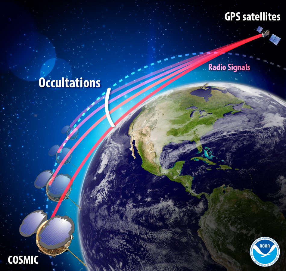
Under the agreement, AER will adapt UCAR’s SatDAACâ software system to process observations from satellites using GNSS radio occultation to observe the atmosphere. Those observations can lead to significantly improved weather forecasts.
From basic research to industry
GNSS radio occultation measures the extent to which the radio signals from GNSS transmitter satellites (including GPS satellites) bend as they propagate through denser regions of the atmosphere.
The measurements can be further processed into information about temperature, pressure, and humidity in the lower atmosphere as well as the electron density in the ionosphere. The technique provides considerable accurate knowledge about a large volume of the atmosphere from near-Earth orbit down to the surface.
Image: NOAA
NASA’s Jet Propulsion Laboratory was first to use radio occultation to profile the atmospheres of Mars, Venus, and the outer planets starting in the 1960s. UCAR, in collaboration with JPL, pioneered the GNSS radio occultation observing technique for Earth’s atmosphere, building on basic research with funding from the National Science Foundation.
In 2006, UCAR began producing the first operational GNSS radio occultation data from a specialized constellation of small satellites known as the Constellation Observing System for Meteorology, Ionosphere, and Climate (COSMIC). The observations from COSMIC led to improved predictions of tropical cyclones and other storms as well as information about space weather and global climate.
A second constellation of small satellites, known as COSMIC-2, was launched in June 2019. It will provide twice as many soundings of the atmosphere with higher quality than COSMIC.
More GNSS-RO satellites coming
Now that the technology has been successfully demonstrated, additional satellites with GNSS radio occultation technology are being launched.
“This technology has moved quickly from being a research concept to providing vital information to forecasters,” said Ying-Hwa “Bill” Kuo. “The original investment in basic research is generating substantial benefits for society.”
Lead GNSS radio occultation researcher at AER Stephen Leroy said, “Earth radio occultation has a nearly 30-year history and has been a revolutionary force in numerical weather prediction and climate science in that time; and now with the commercialization of RO [radio occultation] data, we are looking forward to an explosion in RO data volume. I am really excited that we are performing the operational processing of this new data stream and expanding its scope and utility.”
The UCAR-AER agreement will likely lead to further advances in GNSS radio occultation technology, according to Bill Schreiner, director of the UCAR COSMIC Program.
“By transferring technology to the private sector, AER can take it to the next level in terms of distributing the data and finding new applications that help society,” he said. “This agreement will leverage SatDAAC’s advanced capabilities to develop new products for use by the environmental observing and prediction communities and will help us continue to innovate.”
At least three commercial enterprises are currently developing and deploying nanosatellites and microsatellites that perform GNSS radio occultation — Spire, GeoOptics and PlanetiQ — as well as several international space agencies.
AER works with governments and businesses worldwide to advance understanding of climate- and weather-related risks. The company develops analytical tools to help measure and observe the properties of the environment and translate those measurements into actionable information.
UCAR is a nonprofit consortium of 120 colleges and universities focused on research and training in the atmospheric and related sciences.
Shom, the French national hydrographic and oceanographic office, selected SBG Systems’ inertial navigation systems to renew its fleet.
The office chose the Navsight Apogee inertial navigation systems (INS) for its speedboats and survey vessels for both shallow and deep-water real-time bathymetric surveys and Qinertia PPK software for post-processing tasks.
As a public institution, Shom (Service hydrographique et océanographique de la marine) has three major objectives: national hydrography and cartography, defense support in hydro-oceanographic fields, and support in maritime geospatial products and services for public policies on the sea and the coast.
Shom’s fleet is based in Brest. It is composed of eleven boats, including seven speedboats, and three 59-meter long BH2 survey vessels. They operate on shallow and deep water in France, Africa, the Indian Ocean and in the Caribbean Sea. Shom also uses a fleet based in New Caledonia composed of two boats, one speedboat and a buoy-laying vessel used part of the time for hydrographic surveys.
French agency Shom’s survey vessel. (Photo: Shom)
Renewing the fleet. When it came to renewing the fleet’s INS, Shom looked at INS complying with standards set by the International Hydrographic Organization (IHO) for bathymetric surveys, with a focus on roll and heave that have the biggest impact on the multibeam echo-sounder data compensation.
After having conducted several tests in their official test zone where each element’s location is strictly and precisely known, Shom selected SBG Systems for replacement of its INS.
Shom first acquired a Navsight Ekinox (0.02° roll) for shallow-water survey in New Caledonia, and then decided to outfit the fleet in Brest with the Apogee (0.008° roll).
“The BH2 is highly versatile; it fits both deep and shallow water requirements. Having a homogenized fleet of sensors for speedboats and the BH2 is easier to maintain,” said Rémi Labonde, who is in charge of positioning and hydrographic equipment at Shom.
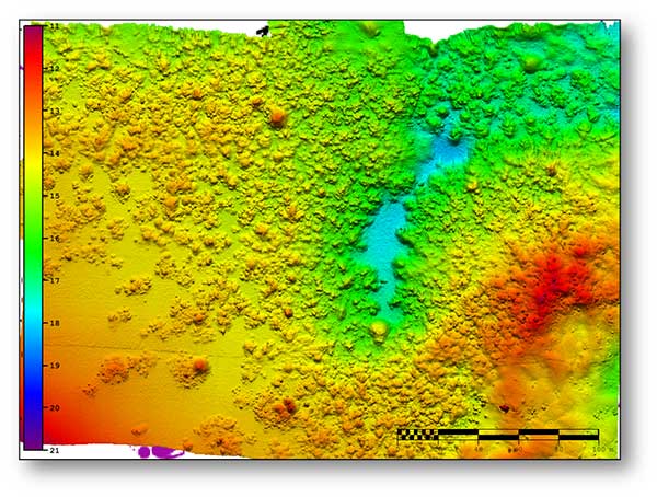
A seafloor survey conducted by Shom. (Image: Shom)
Navsight Apogee INS
Designed for hydrographers, the Navsight Apogee is composed of a GNSS receiver and a processing unit enabling real-time fusion of inertial and navigation data.
Navsight provides connections to external equipment such as echo sounders and computers. With its titanium enclosure, the Apogee sensor can be installed in the floodable engine compartment, close to the multibeam echo sounder.
Navsight marine solution. (Photo: SBG Systems)
Navsight Apogee is a high-performance cost-effective inertial navigation system based on state-of-the-art micro-electrical mechanical (MEMS) technology, and therefore requires no annual maintenance. The SBG solution includes free unlimited firmware updates and technical support.
Once connected through Ethernet, the Navsight web interface guides the installation. For example, a 3D view of the boat shows the entered parameters so that the user can check the installation in real-time.
The embedded filter also controls and validates lever arms and antenna alignment during this procedure, which can be a plus if the Shom needs to calibrate a new system abroad. “We are big fans of SBG’s web interface. It is modern, extremely clear, and easy to use; it really makes a difference in our team’s work,” Labonde said.
Qinertia post-processing software. Navsight Apogee INS accepts real-time corrections from real-time kinematic (RTK) or precise point positioning (PPP).
In its daily surveys, Shom uses PPP positioning, which doesn’t require installation compared to RTK. It also allows offshore surveying, or even near shore when no RTK correction is available.
SBG Systems’ in-house post-processing software Qinertia fixes data issues due to communication cut-outs. The onboard team checks the data and corrects it with Qinertia if needed.
A roundup of recent products in the GNSS and inertial positioning industry from the March 2020 issue of GPS World magazine.
OEM
NavIC modules
Support both L1 and L5 bands
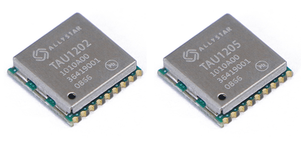
Photo: Allystar
The dual-band multi-GNSS modules TAU1202 and TAU1205 support both the L1 and L5 bands to enhance sub-meter positioning accuracy. Constellations received include GPS, Galileo, GLONASS, BeiDou, QZSS and NavIC. Besides the L1 band, TAU1202 and TAU1205 also support L5/B2a/E5a, which are expected to have lower noise and significantly reduced multipath mitigation because of the higher chipping rate of L5 signals relative to L1 C/A code. TAU1205 supports NavIC (IRNSS), improving navigation in India and the Middle East. Powered by the Cynosure III GNSS chipset and with built-in low-noise amplifier and surface acoustic wave (SAW) filter, TAU1202 and TAU1205 provide higher sensitivity, ensuring exceptional acquisition and tracking performance even in weak signal areas.
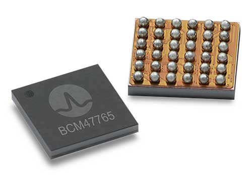
The BCM47765 dual-frequency GNSS module is capable of using the BeiDou-3 constellation’s B2a signals (the Chinese indicator for L5). It can track 30 new L5 signals (60% more) with a significant impact on accuracy. End users will experience much higher reliability of the submeter accuracy inherent to dual-frequency L1/L5. The enhanced L5 signal improves the accuracy of GNSS in an urban scenario by mitigating reflections from nearby buildings (multipath). It also improves GNSS in an open-sky scenario, allowing for submeter accuracy. Second generation dual-frequency GNSS will enable lane-level driving navigation, allowing applications to know in which highway lane a vehicle travels.
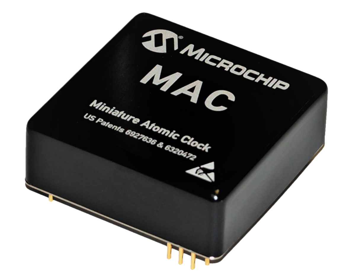
The MAC-SA5X miniaturized rubidium atomic clock is a high-performance atomic clock that delivers a wide thermal range, critical performance improvements and other enhancements over previous clocks. The MAC-SA5X produces a stable time and frequency reference that maintains a high degree of synchronization to a reference clock, such as a GNSS-derived signal. Its low monthly drift rate, short-term stability and stability during temperature changes allows the device to maintain precise frequency and timing during extended periods of holdover during GNSS outages or for applications where large rack-mounted clocks are not possible. Operating over a temperature range of –40 to +75 Celsius, the MAC-SA5X is designed to quickly achieve atomic stability performance with a fast lock.
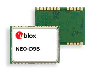
The NEO-D9S GNSS correction data receiver module provides an affordable approach to bringing centimeter-level accuracy to GNSS receivers. The NEO-D9S receives corrections from correction service providers broadcast on the L-band (1525–1559 MHz). A host processor can then decrypt this correction data and provide it to a high-precision GNSS receiver, combining corrections directly with readings from the satellite constellations to enable much more accurate position readings than those offered by GNSS signals alone. Use of the NEO-D9S will also increase the availability of high-precision GNSS positioning data in areas with limited connectivity and reduce the amount of cellular data consumed by positioning receivers. Expected customers are Tier 1 and OEM carmakers, industrial system integrators, and any other applications that rely on very accurate positioning at low cost. The NEO-D9S module is a correction-only receiver. Based on the latest u-blox ninth-generation (D9) platform, it will integrate easily with the u-blox F9 RTK GNSS receivers from u-blox, or can be used as part of a modular product roadmap.
The Qualcomm Snapdragon 720G, 662 and 460 enable enhanced user experiences across connectivity, gaming and entertainment. The new mobile platforms support dual-frequency (L1 and L5) GNSS to improve location positioning accuracy and robustness. The system-on-chip solutions also support NavIC. For the first time on mobile, the Qualcomm Location Suite supports up to seven satellite constellations concurrently, including NavIC.
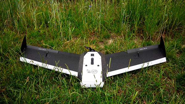
Dedicated to surveying and agriculture, the UAV Birdie is tailor-made, combining intuitive use and high-quality data through precise sensors and GPS RTK L1/L2 onboard. Features include a 24-megapixel camera or optional full-frame 42-megapixel camera; flight time up to 60 minutes; and coverage up to 8 square kilometers in one flight. A vertical-takeoff-and-landing (VTOL) upgrade is available.
Skyfront’s Perimeter 8 drone is equipped with Silvus Technologies’ SteamCaster Radio system, a powerful user-customizable radio system for the military, police and broadcast. The new long-range drone will allow operators to inspect pipelines and other assets as well as conduct long-range surveillance missions. The octocopter can fly for five hours and travel up to 100 kilometers without losing connection from the ground station. Currently, five models are available to suit uses including mapping, lidar and medium, long, or extra-long surveillance. SteamCaster radio system uses the latest beam-forming technology, spatial multiplexing, and space-time coding to ensure the drone can be controlled in environments in which other radio systems are likely to fail. The combination of the technologies allows the range to be increased from 40% to 100%. SteamCaster comes with SteamScape, a network management interface to allow for key metrics and statistics to be viewed and collected in real time. The system also allows the drone to be overlayed onto a map showing the current location and path of the drone.
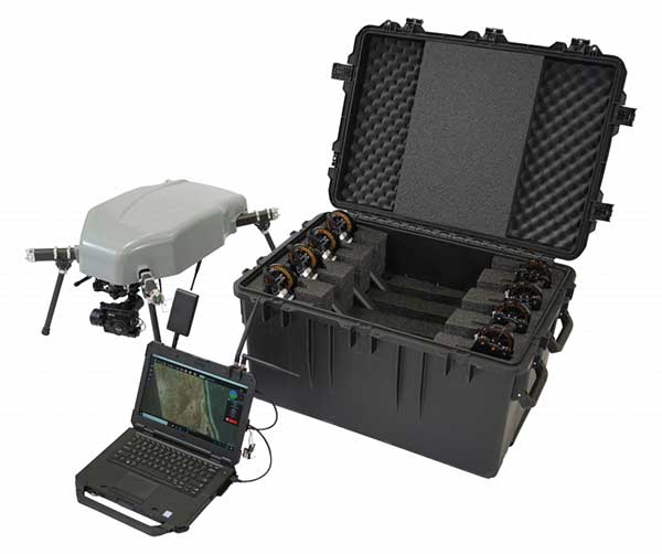
Delivers critical tools on the ground or in the air
Photo: Robotic Research
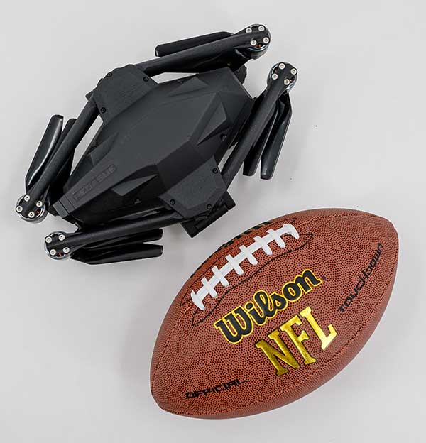
The Pegasus Mini is a smaller version of the Pegasus, a hybrid unmanned aircraft system/unmanned ground vehicle. The Pegasus hybrid UAS/UGV configuration delivers advanced GPS-denied mapping with fully autonomous high-speed flying and driving capabilities. Pegasus Mini is designed to provide the extra reach that a UAV or UGV alone cannot provide. Uses include inspection, rescue, rapid response, and applications that strongly benefit organizations in oil and gas, public transportation, law enforcement, public safety, and more.
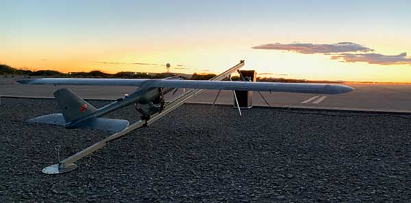
The Silent Falcon E1 UAV has completed 500 hours of successful flight testing and operations. It’s maker, Silent Falcon UAS Technologies (SFUAS), is based in Albuquerque, New Mexico. The E1 solar-electric, fixed-wing UAV is noise free, emission free, and provides long-range, low-cost intelligence, surveillance and reconnaissance (ISR) capability. It has a payload capacity of 20 pounds and a ceiling of 20,000 feet above ground level. SFUAS has an application pending before the FAA for type certification of the E1. The 500-hour milestone confirms for federal regulators that it is safe and durable. Silent Falcon aircraft have operated in eight foreign countries and are not ITAR restricted.
The High Definition (HD) GNSS cloud-based solution enables mass-market devices to achieve sub-meter accuracy across the globe. HD GNSS enables lane-level navigation, augmented reality and virtual reality. It combines precise point positioning (PPP) and real-time kinematic (RTK) positioning methods, allowing for fast convergence time, high availability and global coverage. It also supports off-the-shelf mobile devices and internet of things (IoT) trackers equipped with dual-frequency chipsets.
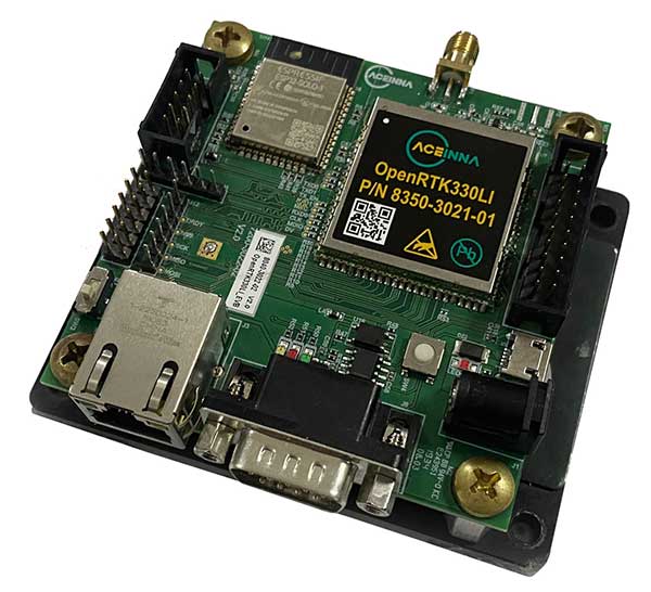
The OpenRTK330L GNSS/INS module is designed for developers creating guidance and navigation systems for autonomous vehicles, robots, drones, industrial, construction and agricultural machinery. OpenRTK330L is a low-cost, high-performance triple-band RTK/GNSS receiver coupled with redundant inertial sensor arrays to provide cm-level accuracy, enhanced reliability, and superior performance during GNSS outages. The module is aimed at automotive, robot, drone, construction and agriculture systems. The multi-band GNSS receiver can monitor all global constellations (GPS, GLONASS, BeiDou, Galileo, QZSS, NavIC, SBAS) and simultaneously track up to 80 channels. The module has RF and baseband support for the L1, L2 and L5 GPS bands and their international constellation signal equivalents.
On April 2, a new museum exhibit will open that focuses on the U.S. Air Force’s role in the management of GPS satellite systems.
The National Museum of the United States Air Force is holding a grand opening event for the new GPS Exhibit from 2-3:30 p.m., with remarks by U.S. Air Force personnel involved with the exhibit followed by light refreshments.
The museum is located at 1100 Spaatz Street, Wright-Patterson Air Force Base, Riverside, Ohio.
On April 2, 2020 a new exhibit will open focusing on the U.S. Air Force role in the management of GPS satellite systems. (Artist’s concept: USAF)
History and Benefits. GPS began as a military navigation tool in the early 1960s. Later, the U.S. Air Force became the lead organization for developing the system. It manages the system, providing highly accurate position, navigation and timing information to users worldwide, for free.
The exhibit describes what GPS is and how it works by outlining satellite and ground systems and their historical development. It explains how atomic clocks and GPS satellites enable all kinds of important activities.
These include mapping and navigation for everyday users and the military, commerce, farming, construction, cell phone systems, the power grid, and climate research.
The exhibit also explains how satellite orbits work, and it outlines the problem of “space junk.”
Hands-on. Interactives and videos help all ages better understand GPS, learn how to find their location on the Earth, and see how orbits and satellites work.
The museum will be open late on opening day, allowing guests to tour the museum until 8 p.m., with an opportunity to walk inside an AC-130A. The Lockheed AC-130 gunship is a heavily armed, long-endurance, ground-attack variant of the C-130 Hercules transport, fixed-wing aircraft.
The exhibit opening will take place in the Space Gallery (fourth building).
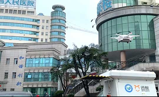
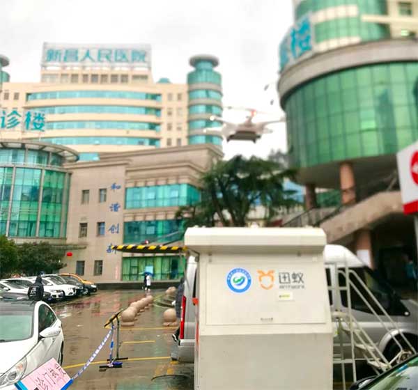
Through its group company Antwork, Japanese company Terra Drone is employing its UAV system to transport medical samples and quarantine supplies in China to fight the coronavirus.
At 9 a.m. on Feb. 6, a medical delivery drone flew from the People’s Hospital of Xinchang County to the disease control center of Xinchang County, marking the launch of the first urban-air transportation channel to help to fight the novel coronavirus (COVID-19 ), a global health emergency.
Take off and landing point of Xinchang people’s Hospital. (Photo: Terra Drone)
The World Health Organization reports at least 95,270 people are infected and at least 3,280 have died. China, where COVID-19 originated, is in a tense period of epidemic prevention and control. Xinchang County is in Zhejiang province — one of the areas most severely hit by the virus.
As soon as the Wuhan quarantine began on Jan. 23, Antwork petitioned to provide drone technical support.
Antwork’s RA3 and tr7s drones and unmanned RH1 station are ensuring that medical samples and quarantine materials can travel with minimal risk between Xinchang County People’s Hospital and Xinchang County’s disease control center. The automatic, unmanned air delivery system significantly reduces contact between samples and personnel, as well as improves delivery speed.
Antwork branch company Aerodeli, which undertook the operation, obtained the first urban drone delivery license issued by the Civil Aviation Administration of China (CAAC) in October 2019. The sample delivery work is carried out in strict accordance with certified operation procedures to ensure the safety of medical samples during transportation.
Take off and landing point of disease control center of Xinchang County. (Photo: Terra Drone)
Using drones has increased the speed of transport by more than 50% compared to road transportation, proving to be a more efficient means of transportation for epidemic prevention and control. The drones also relieve the personnel shortage as more and more medical staff and ambulances are transferred to the front lines — making the best use of human and material resources.
After the project for Xinchang People’s Hospital was put into operation, Antwork began assisting more medical institutions in China to deploy drone transport services for the anti-epidemic effort.
A drone departs from the disease control center of Xinchang County. (Photo: Terra Drone)
Engineers are monitoring in real time the effects on Casablanca’s aging buildings during tunnel construction using a Spectra Precision GNSS receiver.
Vibrations during the construction of a new 1,890-meter tunnel adjacent to Casablanca’s Old Medina, the 250-year-old section of the famed Moroccan city, challenged the stability of its historically important buildings.
To monitor in real time the effects on the Medina’s aging buildings and to confirm that the construction work meets all engineering standards and guidelines, ETAFAT, a geospatial information acquisition and processing company, used the Nikon XF Total Station to perform more than 100 daily inspections. The ETAFAT team relied on optical targets placed on building facades whose coordinates were determined by forced centering to complete the inspections.
The new Les Almohades tunnel, beneath the Boulevard des Almohades, runs parallel and adjacent to the old Medina. Together with its 380 meters of access roads, the twin-tube tunnel, which carries traffic in two unidirectional lanes in each tube, was constructed to reduce traffic congestion.
According to ETAFAT engineers, the Nikon XF 1” with its fast autofocus function, saved considerable field time. The Nikon XF enabled fast collection of highly accurate observations throughout the monitoring and control of the planimetric and altimetric locations of the structure. The monitoring of the buildings during the various phases of the tunnel’s construction generated a large amount of data essential for understanding the consequences of the work and defining any necessary corrective measures.
The Nikon FX 1,” with its advanced options and Survey Pro software, enabled survey teams to quickly yet accurately perform a variety of other essential field tasks.
These tasks include digital terrain modeling (DTM), cubature calculations, coordinate geometry (COGO) topometric calculations and layout control with customized report generation. The use of Survey Pro software enabled ETAFAT engineers to fully integrate their total station work with their fleet of Spectra Geospatial SP60 GNSS receivers.
The Nikon XF 1” is a mechanical total station that stands up to tough worksite conditions. It is designed to quickly capture accurate measurements, and it offers crisp, clear optics for sighting in both bright and low-light conditions.
Its dual-color touchscreen displays run Survey Pro, Survey Basic and Layout Pro.
It is also equipped to take advantage of the optional Trimble Protected L2P device for asset security to locate lost, stolen or missing equipment. Its hot-swappable batteries reduce downtime and a PIN enhances security in the field.
GNSS, coupled with inertial systems and software, is enabling greater accuracy in construction and agriculture. Other markets using machine control include unmanned vehicles, mining, surveying, mapping and defense.
At construction sites, GNSS receivers can be found in heavy equipment such as bulldozers, excavators, graders and pavers. On farms and in orchards, GNSS increases productivity of machines ranging from tractors to UAVs.
A new MarketsandMarkets report predicts the machine control system market will grow to $6.6 billion by 2024, a compound annual growth rate (CAGR) of 8.16%.
For precision agriculture, the outlook is even brighter. Grand View Research anticipates the market will reach $12.9 billion by 2027, a CAGR of 13% over the period.
Machine control speeds projects and increases efficiency under tight timelines. Using GNSS to guide the heavy lifting also alleviates safety concerns related to workers and construction machinery, and provides situational awareness to field operators.
In this month’s feature, we share case studies from companies that specialize in these markets, provide product details, and review the status of real-time kinematic (RTK) GNSS in agriculture.
Check out some use cases for how GNSS, inertial systems and software are enabling greater accuracy in construction and agriculture.
Septentrio has added to its integrated GPS/GNSS receiver portfolio with the AsteRx SB ProDirect, which delivers reliable high-accuracy positioning for machine navigation and control in challenging environments.
The AsteRx SB ProDirect dual-antenna receiver is designed as an “install-and-forget” device to provide continuous positioning for demanding industrial applications, Septentrio said. It gives machines and robotics access to heading and pitch or heading and roll information immediately on power-up. This allows for trajectory path optimization and fully informed navigation from mission start.
The AsteRx SB ProDirect is designed to provide the GNSS positioning and position-independent heading needed for robotics, machine control and similar applications. It uses either a single or dual antennas and is designed for quick integration into any machine monitoring or control system.
Contained in a single, waterproof ruggedized box, the robust receiver uses Septentrio’s LOCK+ technology, optimizing positioning and heading performance under intense mechanical vibrations, shakes or shocks.
Septentrio also offers housed GNSS/INS receivers with inertial integration for a full attitude solution, including heading, pitch and roll, on top of high-accuracy positioning. Integration of the AsteRx SBi’s inertial sensor allows continuous positioning and attitude even during short GNSS outages, which can happen near high structures or under foliage.