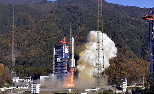
Four new satellites of the BeiDou Navigation Satellite System (BDS) have passed tests in orbit and joined the system to provide positioning, navigation and timing services, according to China news service Xinhuanet.
The four satellites include the 47th, 48th, 52nd and 53rd satellites of the BDS family, according to China’s Satellite Navigation System Management Office.
All of them, operating in medium Earth orbit, were developed by the China Academy of Space Technology under the China Aerospace Science and Technology Corporation.
The 47th and 48th BDS satellites were launched on Sept. 23, 2019, and the 52nd and 53rd BDS satellites were launched on Dec. 16, 2019.
Two to the Last. The China Satellite Navigation System Management Office said the last two Beidou-3 satellite launches will take place in March and May, and complete the Beidou system.
China began to construct its navigation system, named after the Chinese term for the Big Dipper constellation, in the 1990s and started serving the Asia-Pacific Region in 2012.
Over the past two years, China has successfully sent 28 BDS-3 satellites and two BDS-2 satellites into orbit.
China plans to launch more BDS satellites in March and May to complete the global network.
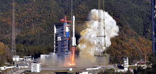
Quantum Reversal has released the QR100, a novel L1/L2 GPS anti-jamming unit, and the QR101, an L1/L2 GPS anti-jamming antenna, designed for the commercial market to solve the issue of unintentional RF interference or jamming.
The QR100 uses three external passive or active GPS antennas of the user’s choice, while the QR101 has three passive L1/L2 antennas embedded inside the enclosure. Low power consumption of 1 Watt and low cost allow for a wide range of applications where the continuity of GPS service is a must.
“Clever RF signal nulling in the RF domain allowed us to eliminate the need for signal processing, and hence, significantly reducing the power consumption when compared to existing military solutions,” said Waldemar Kunysz, Quantum Reversal President and CTO.
The technology prevents the RF front-end from saturation when the interfering signal is very strong due to its power or close proximity to the antenna. This extends the range of the operation for mobile applications and reduces susceptibility to nearby sources of interference for any type of fixed installations.
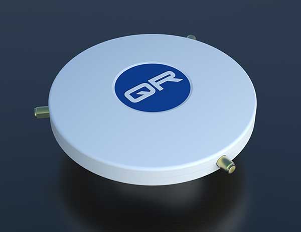
Topcon Agriculture and CropZilla have signed a licensing agreement for use of the Topcon Agriculture Platform (TAP) application programming interface (API) in the CropZilla Web Mobile Analytics platforms.
TAP is a software-to-software interface designed to benefit the end-user by providing a simple and seamless way for sharing data between software systems.
With the Topcon interface, CropZilla is able to acquire machine data from a common device on the machine, adding simplicity and value to each grower wanting to utilize both tools to manage data. Users simply create an account with TAP and CropZilla and the data sharing is effortless, the companies said.
“Topcon’s strategy as it relates to our new digital solution platform is one of partnerships, connectivity, and collaboration. This partnership with CropZilla is the first step of several towards deeper integration with a premier colleague and embodies our philosophy ideally. It demonstrates that two companies can collaborate to provide additional value to the producer, dealer, and OEM,” said Brian Sorbe, VP and GM for Topcon Agriculture.
Brian Watkins, CEO of CropZilla, said, “We’re excited to add Topcon Ag to our expanding ecosystem of partners for CropZilla. We have a common desire with Topcon to create immense value to growers as painlessly as possible. This is only the first step and is a great example of that in action.”
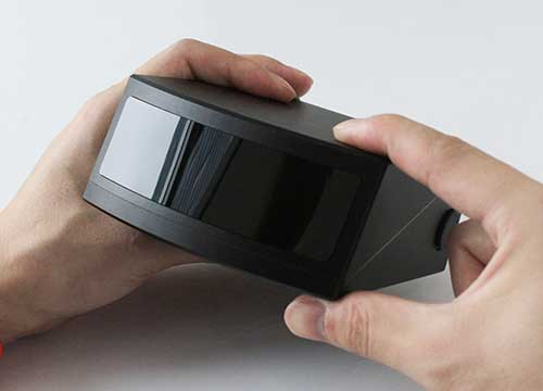
RoboSense is offering the solid-state lidar RS-LiDAR-M1Simple (Simple Sensor Version), which is less than half the size of the previous version at 4.3 x 1.9 x 4.7 inches (110 x 50 x 120 millimeters).
It is equipped with enhanced hardware performance virtually equal to the serial production version provided to OEMs. The main body design of this automotive-grade solid-state lidar is finalized and ready for shipment.
The RS-LiDAR-M1Smart main body is embedded with an artificial intelligence (AI) perception algorithm that takes advantage of lidar’s potential to transform conventional 3D lidar sensors to a full data analysis and comprehension system, outputting semantic-level structured environment information in real time to be used directly for autonomous vehicle decision making.
The RS-LiDAR-M1 family has the performance advantages of traditional mechanical lidar, simultaneously taking into consideration requirements for the mass production of vehicles.
The RS-LiDAR-M1Smart Features
Adapts to complex traffic conditions.
Supports multiple driving scenarios.
Supports dense traffic flow, such as mixing pedestrians and vehicles in intersections during peak hours.
Comprehensive perception of a wide range of dynamic, static and background objects.
Achieves semantic-level prediction for 3D point clouds.
Handles the challenges caused by two-wheel vehicles (motorcycles, bicycles, etc.) and pedestrians who do not follow traffic rules.
Over-segmentation and under-segmentation are fixed based on the clustering algorithm. The robustness against sparse point clouds ensures the integrity of object detection.
Outputs two redundant channels of data: the original point cloud and the object list. The two channels of data are redundant to provide vehicles with a wide range of sensing results, including dynamic and static and inside and outside the road.
Livox Technology Company has introduced two high-performance, mass-produced lidar sensors, the Horizon and Tele-15, which feature a new scanning method that offers improved sensing performance at a low cost.
The lidar sensors are aimed at L3/L4 autonomous driving, smart cities, mapping, mobile robotics and more.
“The growth potential of the lidar industry has been hindered for too long by ultra-high costs and slow manufacturing rates,” said Henri Deng, global marketing director at Livox. “Livox seeks to change this by providing access to high-quality lidar systems that are easily integrated into a wide array of different use applications. Through our technology, we hope to be the catalyst for the rapid adoption of lidar in the quickly growing industries of autonomous driving, mobile robotics, mapping, surveying and more.”
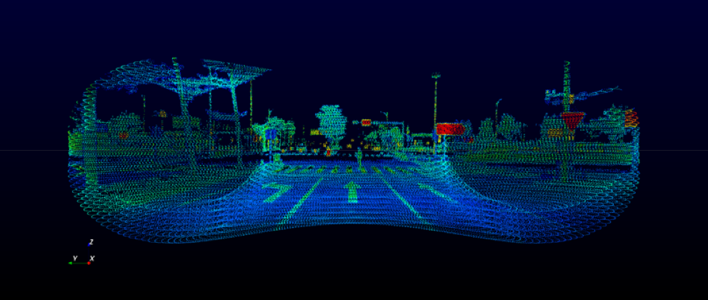
The environment scanned by a Livox sensor increases with longer integration time as the laser explores new spaces within its field of view (FOV). A Livox Mid-40 or Mid-100 sensor generates a unique flower-like scanning pattern to create a 3D image of the surrounding environment.
Horizon point cloud sample of crossroads with a pedestrian crossing the street. (Image: Livox)
Image fidelity increases rapidly over time. In comparison, conventional lidar sensors use horizontal linear scanning methods that run the risk of blind spots, causing some objects in their FOV to remain undetected regardless of how long the scan lasts.
The non-repetitive scanning method of the Livox lidar sensors enables nearly 100% FOV coverage with longer integration time.
The Horizon and Tele-15 are high-performance lidar sensors designed for L3/L4 autonomous driving applications. The Horizon has a detection range of up to 260 meters with a horizontal FOV (HFOV) of 81.7° which can cover four road lanes at a distance of 10 meters. Its FOV coverage ratio is comparable with a 64-line mechanical lidar at the integration time of 0.1 sec. Using five Horizon units enable full 360° coverage.
Made for advanced long-distance detection, the Livox Tele-15 offers the compact size, high-precision and durability while vastly extending the real-time mapping range. The Tele-15 can scan 99.8% area within its 15° circular FOV at 0.1s.
The Tele-15 can successfully detect an object up to 500 meters away. As a result, Tele-15’s performance allows autonomous driving systems to detect remote objects well in advance, providing more reaction time even at high speeds.
Two new small unmanned aerial systems (sUAS) are available to the U.S. government defense and security markets.
Auterion Government Solutions Inc. and Quantum-Systems GmbH have partnered to bring the Vector and Scorpion to market. The partnership brings together high-quality sUAS hardware with a secure, scalable, open source, operating system, Auterion OS.
Auterion OS is employed on sUAS from small multi-rotors to hybrid VTOL Group 2 air vehicles. The open-source operating system aligns with the Defense Department’s Group 1 UAS Architecture.
2-in-1 UAS
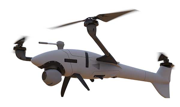
Vector and Scorpion form a 2-in-1 system kit. Scorpion is a tri-copter that can be used for dynamic urban environments and other mission sets that require a combination of maneuverability and hover to collect intelligence, surveillance and reconnaissance (ISR) data, as well as situation awareness information. If required, it comes with a tethering system to enable 24/7 operations.
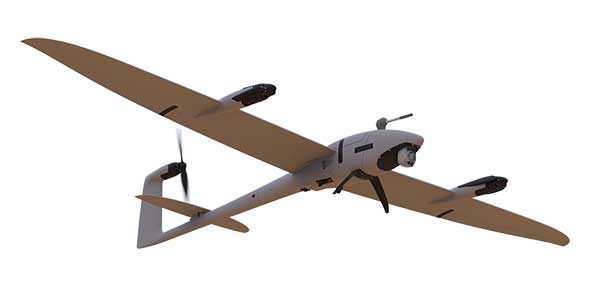
By configuring the base fuselage with fixed wings and tail section, Scorpion transforms into Vector, an energy-efficient, fixed-wing VTOL for longer range, longer endurance ISR missions.
The Vector. (Photo: Quantum-Systems)
Command and control
Quantum-Systems uses a proprietary flight control stack as well as its qBase command and control software on the two air vehicles.
When the platforms are integrated with Auterion Enterprise PX4 software, Auterion Ground Station software, and the Auterion Hand-Held Ground Control Station (H-GCS) they form an open ecosystem that is aligned and integrated with DoD’s Group 1 UAS Architecture and requirements for a common Group 1 control system.
The integration enables these sUAS to be extensible, tailorable and interoperable for customers in both the U.S. defense and security markets.
“We are excited to be working with Quantum-Systems to bring forth a new, integrated, rucksack portable sUAS that we feel will transform the way our customers collect, process and disseminate ISR and Situation Awareness information, in all environments,” said David Sharpin, CEO of AGS.
“By setting up a U.S. entity, Quantum-Systems will move closer to the customer while working on setting up a large-scale U.S. production,” said Florian Seibel, CEO of Quantum-Systems.
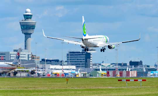
Aircraft throughout Europe are guided by EUROCONTROL, which will have access to ADS-B data through Aireon. Here, a plane lands at Schiphol Airport in The Netherlands. (Photo: Sjo/iStock Unreleased/Getty Images Plus)
Aireon and EUROCONTROL have signed a 10-year agreement to integrate space-based ADS-B data into their air traffic management processes across EUROCONTROL’S 41 Member States and two Comprehensive Agreement (CA) States.
The space-based automatic dependent surveillance-broadcast (ADS-B) data will enhance aircraft management capabilities, contributing to improve predictability, capacity, environmental impact supporting sustainable growth throughout the European region.
It will also support other applications, such as crisis management, contingency management, environmental monitoring, performance monitoring and expanded datasets for post-analysis, traffic statistics and safety-related assessments.
Spanning 43 countries from Turkey to Ireland, Finland to Portugal, EUROCONTROL’s aircraft management states encompass over 11.5 million square kilometers of terrestrial airspace, as well as part of the airspace over the North Atlantic, Mediterranean and Baltic.
Aireon data will be integrated into the EUROCONTROL’s enhanced tactical flow management system (ETFMS), which provides data to European aviation stakeholders, regardless of operational borders, in real time.
Space-based ADS-B data will enrich ETFMS’s complex traffic demand and slot allocation calculations, which currently rely on ground-based surveillance data and flight plan processing systems. As a result, Aireon’s data will support Europe’s primary flow management system to be more accurate in its trajectory predictions and unlock an otherwise unavailable operational capacity.
“With Aireon’s high-integrity, high-quality data, the EUROCONTROL network manager will have the ability to work with information from beyond the European airspace,” said Eamonn Brennan, director general, EUROCONTROL. “Full integration of Aireon space-based ADS-B data will allow us to be more accurate in our trajectory predictions and ensure higher levels of safety, predictability and efficiency in our flow management operations. This partnership is the latest development in our effort to ensure European airspace is one of the most dynamic and efficient in the world.”
EUROCONTROL. Having been nominated as the Network Manager by the European Commission until the end of 2029, EUROCONTROL is driving a coordinated and technologically advanced approach to the challenges faced by the European air traffic network.
Helping address the improvements that are needed in operations, cybersecurity, service provision, crisis management, airspace design, utilization and more, EUROCONTROL provides support and expertise to air navigation service providers (ANSPs), airlines, airports and military partners in the region to help make European aviation, safe, synchronized, efficient and environmentally friendly.
Aerion. In 2019, the European Aviation Safety Agency (EASA) certified Aireon as the first provider of aircraft surveillance-as-a-service. Additionally, Aireon has the only global, single-source dataset available to the industry.
For EUROCONTROL, this means that once the service is integrated into its systems, it will have unprecedented visibility into the full picture of aircraft arriving, departing and crossing over Europe over an area of six flight hours and 3,000 nautical miles around EUROCONTROL Member States.
“EUROCONTROL is a leader in air traffic flow management. They are the first customer to use Aireon data well beyond their own area of responsibility. This will enable them to maximize the effectiveness of their processes and procedures by including long-range arrivals and neighboring States into their capacity and demand measures,” said Don Thoma, CEO, Aireon. “EUROCONTROL recognizes the global value in connecting ANSPs through a common, high-fidelity, global data source that provides situational awareness of actual aircraft position information. We look forward to the benefits all EUROCONTROL customers will see in the near, medium and long-term.”
Aireon’s data will also be integrated in EUROCONTROL’s new system called iNM, which will implement incremental updates to all of EUROCONTROL’s operational systems and digital infrastructure in the course of this decade.
The first two Airbus-built Pléiades Neo imaging satellites have started comprehensive environmental testing to ensure they are ready for in-orbit operation, according to Airbus.
During the tests, the satellites are subjected to extreme temperatures and vacuum, vibration and acoustic noise, as well as electromagnetic interference. This will ensure they can withstand the harsh conditions they will experience during launch and their mission in orbit.
These first two new generation very high-resolution satellites are on schedule for launch in mid-2020. They will join the Airbus constellation of optical and radar satellites, improving both the revisit and resolution capacities.
Entirely funded, manufactured, owned and operated by Airbus, Pléiades Neo will provide institutional and commercial customers with high-level insights for the next 12 years. Each satellite will be adding half a million km² per day at 30-cm resolution to Airbus’ offering.
The images will be streamed into the OneAtlas online platform, thanks to an innovative cloud-based ground segment architecture, allowing customers to have immediate access to freshly acquired and archived data as well as analytics.
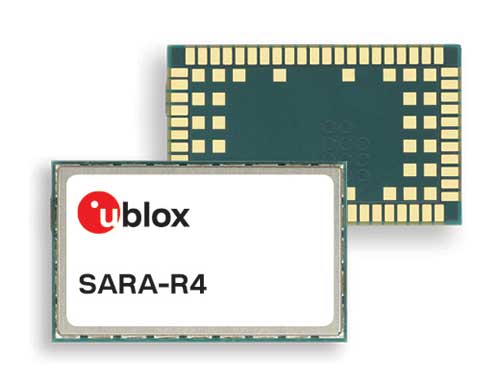
U-blox, a global provider of leading positioning and wireless communication technologies, has extended its SARA-R4 family of LTE-M / NB-IoT and EGPRS cellular modules to include variants with the hardware and software features necessary to enable end-to-end security features and services for internet of things (IoT) data, devices and ecosystems.
“The new SARA-R422 product series offers superior security protection, industrial output power to grant best coverage even in weak signal conditions, and everywhere location using state-of-the-art u-blox GNSS technology,” said Rado Sustersic, senior product manager, Product Center Cellular at u‑blox. “These represent valuable functionalities tailored specifically to the LPWA IoT market.”
M8 GNSS. The SARA-R422M8S is pre-integrated with the u-blox M8 GNSS (global navigation satellite system) receiver and a separate GNSS antenna interface. This provides highly reliable, accurate positioning data simultaneously with LTE communications.
The module also supports hybrid positioning strategies, in which positioning data provided by satellite constellations is enhanced with data from the u-blox CellLocate service, ensuring that location data is always available everywhere.
The SARA-R4 series is designed for a wide range of mission-critical IoT solutions such as connected healthcare, industrial monitoring, point of sale and vending terminals, tracking and telematics devices, as well as smart lighting solutions and building automation.
Security. Security features include a unique and immutable root of trust (RoT) for each device, as well as access to a scalable pre-shared key (PSK) management system. This provides the foundation for a trusted set of advanced security functionalities to enable data encryption and decryption, both on‑device as well as from‑device‑to‑cloud.
The choice of PSK-based security, rather than the more complex and computationally intensive public key infrastructure (PKI) approach, strikes the right balance between implementation costs and level of security protection for many IoT applications.
Robustness. All SARA-R422 modules provide 23-dBm output power, allowing the end device to properly operate in all network conditions. This means no issues at cell edges, no coverage issues in weak signal conditions, and, even more importantly, no unwanted re-transmission that shortens battery life by increasing transmit time and overall system power consumption.
The series is designed for long working lifetimes in the field, through the inclusion of support for LWM2M, a lightweight machine-to-machine communications protocol ideal for IoT applications with the possibility of updating the firmware of modules already in the field over the air via the uFOTA (Firmware Over The Air) client/server firmware service provided by u-blox.
The u-blox SARA-R4 series will be presented at Embedded World in Nuremberg, Germany, Feb. 25-27, at Hall 3/Stand 3-139.
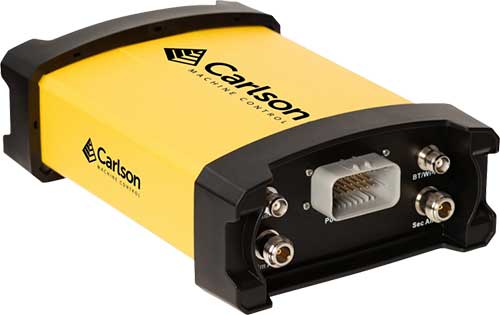
Carlson Machine Control has introduced the Vsx7 multi-frequency position and heading receiver. The Vsx7 is a multi-GNSS receiver designed specifically for machine control and can be installed on excavators, drills, pile drivers and more.
Paired with the Carlson A45 antennas, the Vsx7 features high-precision positioning in Athena RTK, Atlas L-band and SBAS and heading accuracy of up to .01 degrees. The whole Vsx7 system is designed to operate in harsh conditions from -40 degrees Fahrenheit to 158 degrees Fahrenheit. It can be mounted either by bolts or with magnets depending on the application and external environment.
The Vsx7 is primarily used in the mining and construction industries but can be adopted into similar industries with its companion software, Carlson Grade. Field data can be collected and viewed in real-time both at the machine with either, the MC8 or MC10 control box as well as in the office with Carlson Command.
“Our customers are able to operate day after day with complete confidence in their machine guidance,” says Tim Jones, director of Machine Control. “The Vsx7 is a perfect form factor for our customers and to Carlson Grade and Carlson Command as a ruggedized GNSS receiver.”
Carlson Grade is a machine guidance software solution that can be adapted to any heavy machine for grading, excavating, mining, shoveling, drilling, pile driving and landfill operation. Carlson Grade provides real-time field reporting and allows operators to view where they are in the project and at all times.
Carlson Command is a site management software solution that provides multiple viewing options of multiple and single machines in real-time. Command allows machine positions to be viewed as well as cut/fill and elevation. Managers can also remote into machines and transmit messages directly to an operator.
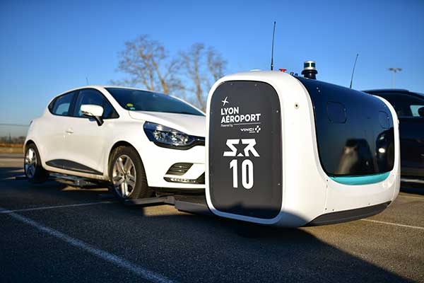
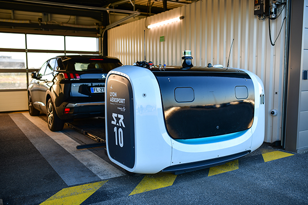
Stan servicing vehicles at the Lyon Airport. (Photo: Stanley Robotics)
Stan incorporates the Trimble BX992 dual-antenna enclosure for accurate, available and reliable localization
The Stanley Robotics team has called on Trimble to equip Stan, its autonomous parking and valet robot, with accurate localization.
To achieve centimeter-level localization, Stanley Robotics needed to combine perception algorithms and intelligent management software with reliable GNSS technology.
“The robot must move fast to handle high traffic flow and precisely to park cars as densely as possible,” said Anthony Troublé, robot team manager at Stanley Robotics. The team selected the Trimble BX992 dual-antenna enclosure and two Trimble AV59 GNSS antennas.
The BX992 is installed inside the robot and the two antennas are mounted on the robot’s head with maximum separation between them. For the robot to attain centimeter-level localization, a Trimble BX992 base and a Trimble Zephyr antenna are installed at the drop-off cabins where customers leave their cars until robots move them to a more permanent location.
The Trimble BX992 base broadcasts real-time kinematic (RTK) corrections over a Wi-Fi link to the robots.
What Stan Does
Photo: Stanley Robotics
With the Stan robotic valet, passengers no longer waste time looking for a free space or trying to locate their vehicle, according to Stan’s creators. After booking their parking space in just a few clicks on the Lyon Airport website, passengers drop off their vehicle in dedicated cabins and make their way to the terminals using the shuttle bus located just a few steps away.
The robot takes care of the car, parking it in the secure car park. When they return, passengers pick up their vehicle, which is waiting for them in one of the cabins.
“The service offers security, simplicity and time savings. With this new technology, parking becomes a no-fuss experience that takes only a few minutes of passengers’ time, leaving them free to travel in a relaxed state of mind,” Stanley Robotics said in a press release.
The system also constitutes a new way of arranging vehicles in a car park and makes excellent use of space since cars can be parked in dense blocks.
In addition, the robot uses two lidar scanners and four cameras. Stan relies on lidar-based simultaneous localization and mapping (SLAM) techniques to locate the robot and build a map. The lidar-based SLAM system is always running and is fused with the GNSS localization and odometry.
“The lidar is mostly critical in the cabins where the GNSS availability and reliability is not sufficient,” Troublé said. “The full integration with our localization system, especially the transition from indoor-to-outdoor when the robot enters a cabin was a challenge. We have tuned and improved our localization fusion algorithm to get the best out of each component and deliver a consistent confidence index.”
Stan is equipped with three levels of safety to ensure operational effectiveness.
First, Stanley Robotics continuously monitors the accuracy, availability and consistency of the RTK GNSS, SLAM and odometry localization signals. “If these signals are too inconsistent or if the overall confidence is too low, the robots are stopped and a site supervisor is alerted,” Troublé said.
Further, the site is monitored through lidars and cameras on the robot to prevent any collision with obstacles.
Finally, a trained Stan maintenance worker is assigned to every parking lot. These individuals wear a safety badge. Every robot is equipped with a safe-stop feature that will trigger if the operator gets within a defined proximity to the robot.
The first outdoor car park managed by robots opened to the public in 2018 at Lyon Saint-Exupéry airport. Since testing started in 2017, four Stan robots are now fully operational in the Lyon Saint-Exupéry airport car park, which can accommodate up to 500 vehicles.
Stanley Robotics announced in January 2019 that they will open 2,000 spaces at Lyon in the summer of 2020. The airport is looking to eventually expand this system to up to 6,000 spaces in total.
In 2019, Stanley Robotics signed a contract with Gatwick Airports, the first U.K. airport to use robots that valet park passengers’ cars. The Stanley Robotics team is gearing up to begin work at another airport to be announced soon.
Telecom, technology and aviation industry leaders join forces to create the HAPS Alliance to connect more people, places and things by using the stratosphere
A group of global industry leaders is forming the HAPS Alliance, an association of world-leading telecommunications, technology, aviation and aerospace companies united in promoting the use of high-altitude vehicles in the Earth’s stratosphere to eliminate the digital divide and bring connectivity to more people, places and things worldwide.
Members who have committed to join the HAPS Alliance include
SoftBank Corp.’s HAPSMobile Inc.
Alphabet’s Loon LLC
AeroVironment Inc.
Airbus Defence and Space
Bharti Airtel Limited
China Telecom Corporation Limited
Deutsche Telekom AG
Intelsat US LLC
Nokia Corporation
SoftBank Corp.
Telefónica S.A.
Telefonaktiebolaget LM Ericsson
The HAPS Alliance is being created so member companies can
collectively advocate for High Altitude Platform Station (HAPS) business development with the relevant authorities in various countries
build a cooperative HAPS ecosystem
develop common product specifications and promote the standardization of HAPS network interoperability
All of these activities will be key to the Alliance’s aim of addressing diverse social issues and creating new value by providing telecommunications network connectivity worldwide through the utilization of high altitude vehicles.
Polar stratospheric clouds. (Photo: Paul Newman, GSFC/NASA)
The Alliance, originally an initiative from HAPSMobile and Loon, will have members from participating leading companies across the aerospace, technology and telecom industries to carry out the Alliance’s activities.
The launch of the HAPS Alliance follows an April 2019 announcement between HAPSMobile and Loon where the companies formed a strategic alliance to advance the use of high-altitude vehicles.
High-altitude network connectivity platforms operate in the stratosphere — above ground infrastructure but below satellites — allowing for near ubiquitous coverage that avoids ground clutter and significant latency issues.
These advantages make such vehicles a promising solution for expanding mobile coverage to areas where connectivity is lacking — mountainous terrain, remote islands, marine regions and developing countries — as well as for IoT and 5G use-cases. The HAPS Alliance seeks to create an ecosystem to support next-generation global connectivity needed to revolutionize the world’s mobile networks.