Author: Tracy Cozzens

  • David Plus GNSS receiver applied in intelligent forklift

    David Plus GNSS receiver applied in intelligent forklift

    Image: Tersus GNSS
    Image: Tersus GNSS

    With the development of intelligent shipping ports, many port-related tools — gantry cranes, loaders and forklifts — can be made autonomous and controlled automatically. These applications use GNSS to obtain positioning and orientation data for machine operators.

    In traditional container-intensive terminals, forklift drivers spend a lot of time locating the designated goods; operating the forklift itself requires highly experienced drivers. Tersus GNSS offers a positioning and orientation solution that can greatly reduce the need for experienced drivers, improve the port’s operational efficiency, reduce error rates and improve accuracy.

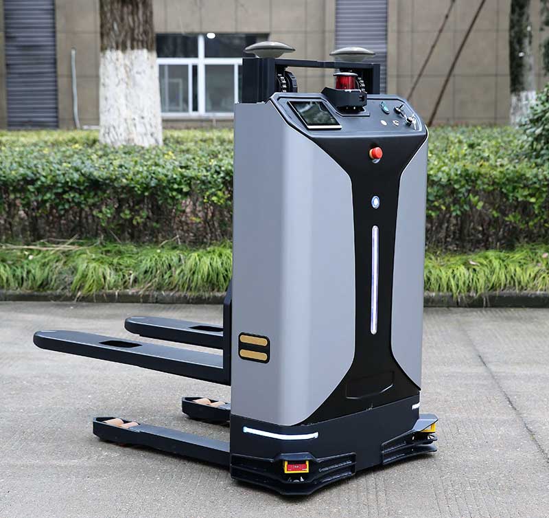
    Installed on an autonomous forklift, a David Plus receiver and anti-interference GNSS dual antenna calculates positioning solutions, enabling operators to locate exactly where the target goods are and guide the forklift to them via the quickest, most convenient routes.

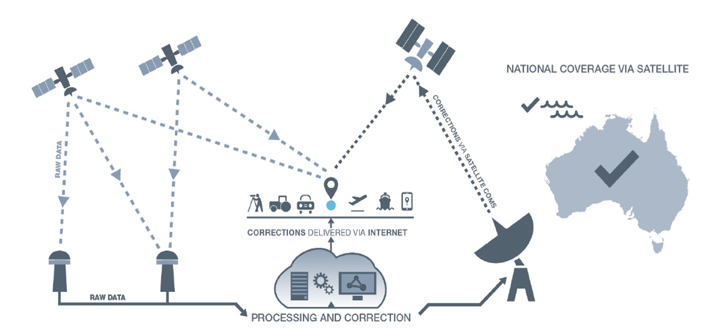
    The David Plus’s compact design can be easily installed on even small forklifts without affecting normal operation. The David Plus obtains high-precision positioning and orientation values by connecting via wireless to an Ntrip network, and then forwards corrections to the port-dispatching system as raw data.

    The David Plus supports GPS L1/L2, GLONASS L1/L2 and BeiDou B1/B2 from the primary antenna, and GPS L1/GLONASS L1 or GPS L1/BeiDou B1 from the secondary antenna. Its 384 channels can capture numerous satellite signals within a short time.

    Image: Tersus GNSS
    Image: Tersus GNSS

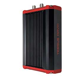
    With an IP67-rated enclosure, the David Plus GNSS receiver is built for outdoor environments such as shipping ports. A palm-sized unit, it can be easily integrated with various application systems. As a backup data-saving measure, 4 gigabytes of built-in memory record data for post-processing.

    A manned forklift can benefit from the positioning data. When the forklift reaches the designated position in the stack, the heading antenna will calculate the correct lift height of the forklift arm. This provides a suitable height for handling the cargo, and prevents accidents such as the cargo falling.

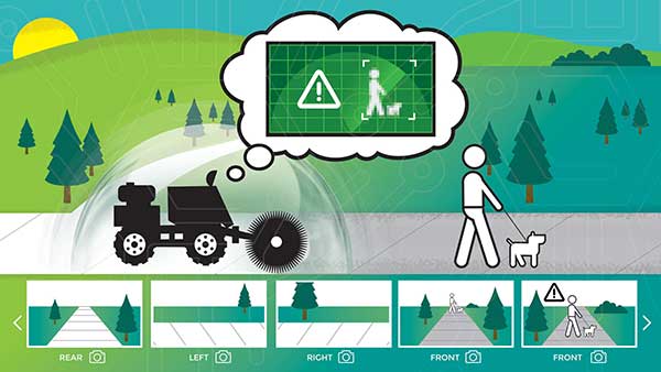
    For a fully autonomous forklift, the system will automatically analyze the orientation data and lift the forklift arm to the corresponding height of the cargo. It will then retrieve and lower the cargo to a safe height, and automatically drive it to the new storage point. During this process, additional infrared obstacle avoidance sensors can accurately identify the distance between the forklift and the cargo, avoiding inadvertent collisions.

    The positioning and orientation data obtained by the David Plus can be shared with third-party software and hardware. For instance, port terminal systems can configure containers to capture distribution information and instructions. By importing the positioning information of the forklift equipped with David Plus into the system in real time, it is possible to calculate the optimal driving trajectory to the final cargo delivery point.

    The Tersus David Plus positioning and orientation solution can combine its own high-precision positioning and orientation data with other automation system hardware and software to form a complete forklift unmanned/manned automated driving and handling solution.

  • Seen & Heard: Drones and robots fight coronavirus

    Seen & Heard: Drones and robots fight coronavirus

    “Seen & Heard” is a monthly feature of GPS World magazine, traveling the world to capture interesting and unusual news stories involving the GNSS/PNT industry.


    Drone with megaphone. (Screenshot: Xinhuanet video)
    Drone with megaphone. (Screenshot: Xinhuanet video)

    Drones and robots fight Coronavirus

    China’s efforts to contain the coronavirus include drones and robots, according to news reports. Drones are being used to spray disinfectant and enforce instructions to wear face masks. Some reports say drones with thermal imaging are detecting people with fevers from the air. On the streets, hazmat workers are using tank robots to disinfect 50,000 square meters per hour. Other robots are feeding quarantined air passengers at a hotel and disinfecting rooms.


    Jakarta toll road. (Photo: GeorginaCaptures/iStock Editorial/Getty Images Plus)
    Jakarta toll road. (Photo: GeorginaCaptures/iStock Editorial/Getty Images Plus/Getty Images)

    Hungary helps Indonesia with road tolling

    Indonesia and Hungary are in talks to build a multi-lane free flow (MLFF) e-toll system that allows payments without gates while cars are moving. The technology is estimated to cost US$90 million. The GNSS e-toll system is already installed in several eastern European countries, including Hungary. Using GNSS, motorists are charged tolls through sensors installed inside vehicles that identify their locations.


    Photo: Anne Webberi/iStock/Getty Images Plus
    Photo: Anne Webberi/iStock/Getty Images Plus/Getty Images

    Albatross on patrol

    The albatross, which has a wingspan as long as 11 feet, is helping catch illegal fishing vessels. Henri Weimerskirch of the French National Center for Scientific Research has outfitted nearly 200 albatrosses with GPS trackers that detect radar from ships that lack an automatic identification system. This allows the birds to transmit the locations of fishers in the midst of illicit acts. Fishers who trawl without a license, exceed quotas or underreport their hauls imperil fragile ecosystems and cost the global economy up to $30 billion a year.


    A black bear in Shenandoah National Park. (Photo: USNPS/Neal Lewis)
    A black bear in Shenandoah National Park. (Photo: USNPS/Neal Lewis)

    How fare the bears?

    When problem bears are relocated outside the Great Smoky Mountains, 74 percent are never seen again. Do they thrive after being moved at least 40 miles from their home range? Upcoming GPS research may figure out what happens to them. “There is a mindset where everybody thinks we can just go catch a bear and move it somewhere else, and everything is okay. And it’s not,” said wildlife biologist Bill Stiver. The U.S. National Park Service has approved a three-year grant for a GPS research project beginning in 2021 to track bears relocated from the Great Smoky Mountains National Park and Shenandoah National Park in Virginia.

  • MGISS launches web app for visualization of buried assets

    MGISS launches web app for visualization of buried assets

    Image: MGISS
    Image: MGISS

    MGISS, a U.K. geospatial specialist, has released a new version of its web app TopoGrafi that allows for the display of 3D data in real-world models. With enhanced 3D data processing capabilities, TopoGrafi is an end-to-end platform for capturing buried asset data and processing it for augmented reality visualizations.

    Aimed at the utility and infrastructure sectors, TopoGrafi is helping organizations in water and highway sectors enhance asset location data, improve on-site safety and reduce construction and maintenance costs.

    Designed to be used alongside apps such as Esri Collector for ArcGIS, the TopoGrafi platform uses GNSS data.

    It applies near-real-time conversions, transforming the recorded positions to local reference systems and aligning it with high-accuracy mapping including Ordnance Survey MasterMap.

    The TopoGrafi toolkit also includes functionality to “snap” 3D features to each other and to other spatially referenced data, in order to create a true 3D model that can then be used to create Augmented Reality visualizations accessible from the desktop or in the field.

  • GNSS to assist construction on tunnel from Germany and Denmark

    GNSS to assist construction on tunnel from Germany and Denmark

    When completed, the underwater auto and rail tunnel will connect Germany and Denmark. (Image: Femern A/S)
    When completed, the underwater auto and rail tunnel will connect Germany and Denmark. (Image: Femern A/S)

    A European megaproject is relying on GNSS to guide supportive earthworks during construction. The Fehmarn Belt Fixed Link is a planned underwater tunnel that would allow travelers to go by car or train between Germany and Denmark in only seven to 10 minutes. Once completed, the 18-kilometer-long tunnel will be the world’s largest of its kind and is expected to employ up to 3,000 people.

    The 7 billion Euro project is expected to be completed in nine years. Danish construction company Holbøll A/S is building earthworks for 56 bridges on the main route crossing Denmark to where the tunnel would start. Holbøll’s undertakings include ramps and drainage work for the new bridges.

    Holbøll has 130 employees and a machine park of 22 machines equipped with machine control from Leica Geosystems, enabling it to deliver innovative and sustainable solutions on time and at the agreed price.

    At one of the bridges in Vordingborg, operator Flemming Ove Nielsen uses a Leica iCON GD4 3D system on the 61PX Komatsu dozer to perform the first rough work for building the slopes. Using the the iCON GPS 80 receiver, the iCON grade iGG4 system ensures fast and reliable grading with GNSS. Nielsen uses machine control to create the slope, and then the excavator takes over for the final grading work.

    Image: Femern A/S
    Image: Femern A/S

    “The dozer is very efficient for this sort of work because it can move so much dirt and, with machine control, hold the correct angle of the blade,” explained Carl-Ole Holbøll, co-owner and managing director of Holbøll. The dual GNSS solution for the dozer is an advantage because the slope is so steep, and to achieve an accurate cross-slope, dual GNSS is required.

    On another bridge, an excavator is using the Leica iCON iXE3 3D system for the finishing layer of the ramp slope. The operator can document the height of the different dirt layers simply by placing the bucket and letting the iXE3 register the height. This saves time — the operator doesn’t have to wait for a surveyor to conduct as-built documentation for each layer.

    The Fehmarn Belt Fixed Link prime contractor, Femern A/S, has taken the next steps to develop the area where the factory for the tunnel elements will be built. Continued archaeological surveys, preparatory supply infrastructure and drainage has been financed at 55 million Euros.

    Geared with Leica Geosystems, Holbøll A/S has prequalified for several of the derived projects, including the draining and moving of eight hectares in Strandholm Lake in Denmark.

  • Site contractor gains productivity edge with grade control platform

    Site contractor gains productivity edge with grade control platform

    The automatics on Trimble’s Earthworks Grade Control Platform enabled construction of a tricky retaining wall. (Photo: Trimble)
    The automatics on Trimble’s Earthworks Grade Control Platform enabled construction of a tricky retaining wall. (Photo: Trimble)

    Based in Vandalia, Ohio, R.B. Jergens has long been an early adopter of technology. The company purchased its first GPS-based surveying equipment, a Trimble base station and rover, in 1999 and has never looked back.

    The company has relied heavily on the Trimble GCS900 Grade Control System with automatic blade control for years, and recently put the new Trimble Earthworks Grade Control Platform to the test on several of its excavators.

    “While the user interface is completely different, moving from a soft key control box to a touchscreen control box, the transition from the GCS9000 has not been difficult,” said David Reynolds, surveying manager with R.B. Jergens.

    The new Earthworks platform includes intuitive, easy-to-learn software, is extremely customizable, and allows each operator to personalize the interface to maximize productivity, regardless of his or her experience or skill level. When the excavator is placed in “autos” or automatics mode, the operator controls the stick, and Trimble Earthworks controls the boom and attachment to stay on grade for a more consistent grade and higher accuracy in less time.

    One of the first jobs that the R.B. Jergens team used the Earthworks Grade Control Platform on was to construct a 1,000-foot-long ditch with a very flat profile of about 0.2%.

    A transmission tower complicates construction. (Photo: Trimble)
    A transmission tower complicates construction. (Photo: Trimble)

    “For this type of task, the automatics functionality is invaluable, because an operator would have a very difficult time maintaining fall,” said Reynolds. “It averages out to less than 3 inches over 100 feet, which is almost impossible to eyeball.”

    Traditionally, on a job with that flat of a profile, the surveyor would have had to set frequent grade stakes.

    “We used the automatics feature to construct the ditch and ensure that it held a consistent profile per the design specifications, even though the profile is extremely flat,” Reynolds said.

    A particularly challenging automatics-enabled project was the excavation near a transmission tower for construction of a soil nail retaining wall. Crews needed to excavate around the tower without undermining the integrity of its foundation.

    The soil nail retaining wall is 25 feet tall and about 150 feet long. To complete the job, the R.B. Jergens crew would excavate and expose up to five vertical feet of the bank face. Then the retaining wall contractor would drill holes in the soil, install and grout the steel rod, attach plates, and cover the face with a cementitious shotcrete. “We used the autos on the excavator to perform all of the excavations,” Reynolds said. “Without machine-controlled guidance and the automatics capability to pull those slopes in so tightly, I’m not sure how we’d have done this job.”

    Reynolds estimates that the surveyor and field crews saved three days of time each on the job — at least 40 hours total — with the use of automatics.

    “We’ve been able to reallocate resources more effectively and increase our productivity anywhere from 50 to 100%, so we’re leaner and more profitable.”

  • New Ubihere technology fills in for GPS indoors

    New Ubihere technology fills in for GPS indoors

    The dashboard shows how Ubihere tracks with both camera and tag technology. (Screenshot: Ohio Development Services Agency)
    The dashboard shows how Ubihere tracks with both camera and tag technology. (Screenshot: Ohio Development Services Agency)

    Ubihere has introduced a new 2D and 3D tracking technology for indoor and outdoor positioning.

    Ubihere’s patented technology provides real-time asset location and information without GPS, making it an alternative for GPS-denied environments.

    From Space Walks to Retail Stores

    The inventor of the technology is geoinformatics professor Alper Yilmaz of The Ohio State University (OSU), who researched how to geolocate undercover officers based on motion video information, as well as astronauts on space walks.

    OSU urged Yilmaz to commercialize his technology, and Rev1 Ventures served as the incubator. Ubihere launched under Rev1’s portfolio in 2016 in Columbus, Ohio.

    Ubihere’s system is based on anonymous video analysis positioning technology, which is patented from OSU, coupled with tag technology and advanced machine learning analytics. The system’s tags, cameras, and software track assets to the centimeter. The assets are monitored through an anonymous video feed or the tags themselves, which are about the size of a credit card, and non-RFID.

    The map for indoor environments can be generated from a building information model (BIM). Based on the building’s architecture, movement is tracked. In milliseconds it can hone in on an exact location within a centimeter, explained Alice Hilliard, Ubihere’s vice president of business development.

    The location data is transmitted to a server or the cloud, depending on the customer’s preference. It is then loaded into dashboards that can be accessed from any device the client requests.

    If a tagged object leaves a building, it will continue to be tracked with or without GPS. If the object stays within the building, it will never use GPS. Using GPS shortens the battery life, which ranges from 18 to 24 months. Battery life is also affected by the number of floors, temperature and usage.

    Launching in Hospitals and Retail Stores

    The tag offers a way to calibrate location in places such as hospitals, where tracking food carts or devices through lead-lined walls enables hospitals to maximize their efficiency.

    “Imagine how many times a nurse or other caregivers go back and forth,” Hilliard said. “By tracking how people and objects move around, we can help departments figure out opportunities to lay out the floor better to allow the staff to save time and steps.

    “With a blueprint loaded into the software,” Hilliard said, “the system knows whether a (tagged) IV pump went down the hall, turned left or right, entered an elevator, or was left in a patient’s room.”

    The cameras can be installed in locations such as retail stores, enabling Ubihere to anonymously track a customer’s journey. Used together, the tag and camera can help stores determine whether a display is working, showing how many customers came in to shop, or how many looked at or touched items in a particular display.

    For ecommerce, customer behavior can be tracked automatically in real time with Google Analytics and other SEO tools.

    Other possible uses include factories and emergency-response teams. “If you were in a factory or even a nuclear power plant, OSHA guidelines establish that you have to have two people in the control room at all times,” explained Hilliard.

    “Periodically, OSHA is required to monitor if the power plant is following that protocol. Instead of having someone sit there and oversee the situation, we can use our camera technology to anonymously collect workers’ whereabouts, which can then be easily pulled from the cloud. For response teams, an equipment failure that makes it difficult to locate a team member could be overcome with the tag technology. “

    Ubihere’s machine-based algorithms can learn locations based on various types of sensors, Yilmaz said, adding that detecting odors isn’t out of the question.

    The startup is now exploring potential applications of its GPS-free tracking technology. While initially focusing on beta tests in hospital and retail environments, Ubihere also has three projects with the U.S. Department of Defense.

  • Autonomous track construction saves time, improves profitability

    Autonomous track construction saves time, improves profitability

    Photo: Trojak Communications
    Photo: Trojak Communications

    The most often cited reason for a company’s reluctance to move toward a GNSS-based capital equipment purchase is cost. Not so for the Redland Company, which embraced GNSS long ago and employs it in almost every facet of its operation.

    On a unique 475-acre Florida Department of Transportation (FDOT) project, Redland used millimeter-grade GNSS on a Gomaco 9500 trimmer to final grade a 2.25-mile oval track, saving months over traditional string line grading. For Redland, the solution has gone from a necessary expense to an entirely new profit center.

    The FDOT SunTrax project includes construction of a proving ground for autonomous vehicles. When complete, the 200+-acre center will offer a test chamber to simulate weather, an area where pick-ups and drop-offs can be replicated, and a precision-graded 2.25-mile oval test track.

    The oval is designed to replicate turnpike travel at 70 mph. “Because FDOT had some very strict tolerances on the track surface itself, the grade had to be extremely precise,” said Walt Thomas, Redland’s division superintendent for grading/trimming operations. “So when we got out here, all the rough grading had been completed and we were brought in to prepare it for the asphalt course.”

    Neatly trimmed

    Photo: Trojak Communications
    Photo: Trojak Communications

    For ultra-fine grading, Redland uses a trimmer/placer that offers advantages over a motor grader, including an ability to resist “floating” over higher density material or cutting into lower density material. To maintain grade, trimmers typically are used in conjunction with a string line which, while effective and accurate, is also labor-intensive, time-consuming and challenging.

    Because of the project’s size, Redland has used Millimeter GPS from Topcon Positioning Systems on its Gomaco 9500 for more than two years. “We have gotten tremendous results with it,” Thomas said. “We knew that, for here, it was the only viable trimming approach.”

    Redland’s Millimeter GPS uses a series of tripod-mounted Topcon LZ-T5 laser transmitters placed at an established reference point to generate a 33-foot-high Laser Zone signal. That signal is accessed by the receiver on the trimmer and used to determine elevation, set the necessary depth of the trimmerhead, and maintain the required tolerances.

    While most of the project only needed two lasers, four were used for the curved sections of the oval track, including a turnaround loop for testing larger autonomous vehicles like semi-trailers. “Trimming anywhere from 1 to 2 inches of material, we were averaging rates of about 800 square yards per day — and the accuracies have consistently been dead on,” Thomas said.
    The machine running the millimeter-grade system is in steady demand by many of the area’s premier grading contractors in Florida and North Carolina. “For us, it has paid nice dividends,” Thomas said.

    Comfort in 3D

    Photo: Topcon
    Photo: Topcon

    Topcon equipment that Redland Company used for the SunTrax construction included the 3D millimeter system, the Topcon HiPerV base and rover, laser units and FC-5000 controllers, purchased through Lengemann Corporation in Altoona.

    For Redland, Topcon GNSS solutions “have been great for our own operation and a powerful solution to offer as a subcontractor,” Thomas said. “We are getting to a point here in Florida where having a 3D capability is almost a prerequisite for bidding many jobs. No problem, we are already there.”

    The SunTrax facility is being jointly developed by Florida’s Turnpike Enterprise (FTE), Florida Polytechnic University and industry partners. The cutting-edge facility, which will offer unique opportunities for testing emerging transportation technologies in safe and controlled environments, is being touted as the only high-speed autonomous vehicle testing facility in the southeastern U.S.

    SunTrax is slated to open this year.

  • Parkinson talks to Google about ‘GPS for Humanity’

    Parkinson talks to Google about ‘GPS for Humanity’

    Steve Malkos, Android Context Group, Google
    Steve Malkos, Android Context Group, Google

    We’ve come a long way since the inception of GPS. Today, location often is taken for granted, but that’s true of every mainstream technology.

    It’s absolutely remarkable how far the technology has evolved. From receivers that were as big as backpacks to tiny chipsets supporting multi-constellation dual-band GNSS receivers in smartphones with antennas that are etched into the body of cell phones, it’s really an amazing technology.

    I’ve had the privilege to work on GPS in phones since before “smart” appeared in front of them. And it’s truly amazing to see how “GPS has revolutionized our day-to-day lives.” But this is not my quote.

    In January at the Google campus in Mountain View, California, we hosted Dr. Brad Parkinson (widely known as the Father of GPS) who gave a talk on this subject. He was the one who called this a revolutionary technology, and that had been a stealthy revolution. Frank van Diggelen secured Brad to come to Google to give this talk.

    His talk was titled “GPS for Humanity.” In the talk, available on YouTube (see below), Brad goes over first hand how, over the past 30 years, this new utility came into being. It came into the fabric of our worldwide society, creating dependencies that did not exist before.

    He detailed how GPS was created, what technologies were essential to its success, all the various ways that GPS keeps crucial processes intact, and how it supports a $1.4 trillion economic impact that this system brings us today.

    It was a privilege and honor to have Brad give a candid and timely talk, and I hope you enjoy it as much as we did!

    To watch his talk, search for “Brad Parkinson Talks at Google” on Google or YouTube. Or follow the link


    Steve Malkos is the lead technical program manager in the Android Context Group at Google.

  • Australia, New Zealand commit to develop SBAS by 2023

    Australia, New Zealand commit to develop SBAS by 2023

    Australia and New Zealand are partnering to roll out satellite technology that will be able to pinpoint a location on Earth to within 10 centimeters, unlocking more than $7.5 billion in benefits for industries in both countries.

    Prime Minister Scott Morrison and New Zealand’s Prime Minister Jacinda Ardern committed jointly to implement a satellite-based augmentation system (SBAS), to operate across Australia and New Zealand, at the Australia-New Zealand leaders’ meeting held Feb. 28.

    The system will improve the accuracy of GPS and other positioning services from the current five to 10 meters to as little as 10 centimeters across Australia and New Zealand without the need for mobile or internet coverage.

    The new project follows 18 months of successful trials that tested 27 projects across a range of industries. It will be delivered by Geoscience Australia and Land Information New Zealand under the joint science research and innovation treaty.

    Minister for Resources, Water and Northern Australia Keith Pitt said the project, to be operating by 2023, will have significant benefits to a range of industry sectors including mining, agriculture and transport.

    “We welcome New Zealand’s commitment to join Australia in rolling out this exciting new technology, which will deliver substantial economic benefits for both countries,” Minister Pitt said.

    “An independent analysis by Ernst and Young (EY) has found improved positioning technology will deliver more than $6.2 billion in benefits for Australia, and more than $1.4 billion in benefits for New Zealand, over the next 30 years.

    Image: Geoscience Australia
    Image: © Commonwealth of Australia (Geoscience Australia) 2020

    “Trial projects have also found the system can make our roads and rail systems much safer, and can improve the way farmers manage their land, crops and livestock. For the resources sector, the technology can track vehicles and improve site surveys to enable precise extraction of deposits.”

    Industry, Science and Technology Minister Karen Andrews said the project will complement Australia’s other investments in space to drive economic growth and create new jobs.

    “The Morrison Government is backing these types of technologies because of the positive impact they have on the lives of everyday Australians — from the discoveries that make life easier through to growing industries that create high-value jobs,” Minister Andrews said.

    “Many industries stand to benefit from this technology. It could help improve safety and efficiency in aviation and shipping and will be crucial to the development of autonomous vehicles.

    “This work also supports our government’s broader commitment to triple the size of the space sector to $12 billion and an extra 20,000 new jobs by 2030.”

    More information about accurate satellite positioning is available on the Geoscience Australia website.

  • Left Hand Robotics launches BOLT for outdoor automated equipment

    Left Hand Robotics launches BOLT for outdoor automated equipment

    Image: Left Hand Robotics
    Image: Left Hand Robotics

    New BOLT platform enables equipment manufacturers to automate outdoor jobs, adding autonomous navigation, connected sensors and real-time operations to machines.

    logo-Left-Hand-RoboticsLeft Hand Robotics, a manufacturer of self-driving smart robots for commercial turf and snow, has launched BOLT, a technology platform that transforms outdoor machinery and power equipment into smarter, more efficient, ready-to-work robots.

    BOLT brings autonomous navigation, connected sensors, and real-time robot operations to outdoor power equipment and machines doing repetitive jobs across the globe. Building on Left Hand Robotics’ field-proven experience with its own robot tractors, BOLT allows OEMs to launch faster, reduce R&D costs, and tap into a unified platform with navigation, sensors, controls, software and apps.

    BOLT focuses on several key areas to help with machine automation, including:

    • autonomous navigation and telemetry
    • smart sensors and cameras
    • connected power equipment and controls
    • cloud-based robot operations center and apps
    • job planning, reporting and analysis

    Because each OEM is likely to have different requirements or product needs, BOLT partners go through multiple deployment phases, including evaluation, development and deployment.

    Partnering with OEMs. Left Hand Robotics soft-launched BOLT earlier this year and interest has been high from manufacturers needing more automation capabilities. The company is now collaborating with power equipment and machine manufacturers to incorporate BOLT features into their future product lines.

    “Our team has learned a lot, building, testing, proving how autonomous tractors can work on tedious, dirty jobs in the real world. These are tough problems to solve and we have already invested more than 80 engineering years into the technology behind BOLT,” said Terry Olkin, CEO for Left Hand Robotics. “We’ll continue to build our own robots while offering BOLT to a limited number of OEMs in the first year.”

  • Swift Navigation and Deutsche Telekom announce partnership

    Swift Navigation and Deutsche Telekom announce partnership

    California-based Swift Navigation is partnering with Deutsche Telekom, an integrated telecommunications company based in Bonn, Germany. The partnership brings the precise positioning of Swift’s Skylark Cloud Corrections Services to Telekom’s comprehensive communications infrastructure via its new Precise Positioning product offering.

    The Precise Positioning service is available across the United States and Germany, with expansion across Europe underway.

    Autonomous applications. Autonomous applications, which rely on positioning accuracy, include self-driving cars, rail, autonomous robotic machine navigation, autonomous flight for unmanned aerial vehicles, last-mile delivery logistics, construction safety, and shared mobile positioning.

    Swift and Telekom’s lane-level accurate Precise Positioning is specifically designed for level 2 and 3 automotive applications including advanced driver-assistance systems (ADAS), such as lane assist, highway autopilot, cellular vehicle-to-everything (CV2X) communications and lane level directions.

    Standard GNSS positioning is accurate to three to five meters — unsuitable for autonomous systems. For higher levels of autonomous capability, high-precision localization is required to deliver accuracy down to the centimeter. This partnership brings the <10-centimeter accuracy of Swift’s precise positioning solution to Telekom customers.

    Precise Positioning is a wide area, cloud-based GNSS corrections service that delivers real-time high-precision positioning to autonomous vehicles. Built from the ground up for autonomy at scale, the Precise Positioning service enables lane-level positioning, fast convergence times and high integrity and availability required by mass market automotive and autonomous applications.

    Image: Swift
    Image: Swift

    Hardware-Independent. The service is hardware-independent, allowing customers to choose their GNSS sensor ecosystem. It delivers a continuous stream of multi-constellation, multi-frequency GNSS corrections for a high-availability service that combines lane-level accuracy and world-class integrity at a continental scale.

    “Swift Navigation is excited to continue our work with Telekom to bring Swift’s precise positioning GNSS expertise to Telekom’s broad customer base,” said Timothy Harris, co-founder and CEO at Swift Navigation. “This partnership is just the beginning of our joint service offering for autonomous vehicles across the EU.”

    “Precise Positioning opens the doors to true autonomous mobility. Precise, safe and in the future also cross-national,” said Hagen Rickmann, responsible for business customers at Deutsche Telekom. “We are thus offering our customers an easy entry into the autonomous future. And we’re not just thinking of self-driving vehicles: The flexible offer is also suitable for use with drones and is even of interest to crane operators on construction sites.”

    For ease in testing and integration, Swift and Telekom have created a Precise Positioning Evaluation Kit. The kit includes two workshops (onboarding and result review), testing hardware and software to connect to the Precise Positioning network for a three-month evaluation period and is available to purchase.

    Image: Swift
    Image: Swift
  • Belarus to start sharing GNSS data with European network

    Belarus to start sharing GNSS data with European network

    EUREF Permanent Network. (Image: EUREF)
    EUREF Permanent Network. (Image: EUREF)

    Belarus will soon be sharing GNSS data with the EUREF Permanent Network (EPN), the press service of the State Property Committee of Belarus told Belarus news agency BelTA.

    Beginning March 1, the Belarusian state enterprise Belgeodeziya will start uploading data to two GNSS data processing centers. Until now, Belarus has been the only European country without a EUREF Permanent GNSS Network (EPN) station.

    The EPN consists of

    • a network of continuously operating GNSS (GPS, GLONASS, Galileo, Beidou.) reference stations
    • data centers providing access to the station dat,
    • analysis centers that analyze the GNSS data
    • product centers or coordinators that generate the EPN products
    • a central bureau responsible for the daily monitoring and management of the EPN.

    The EPN network is operated under the umbrella of the IAG (International Association of Geodesy) Regional Reference Frame sub-commission for Europe, EUREF.

    Instructed by the State Property Committee, Belgeodeziya has added four Belarusian GNSS stations to the EPN, which unites more than 100 European agencies and universities.

    Joining the network will provide Belarusian geodesists with direct access to international standards on the operation of permanent GNSS stations.