Author: Tracy Cozzens

  • Semtech releases LoRa Edge for IoT asset tracking

    Semtech releases LoRa Edge for IoT asset tracking

    Image: Semtech
    Image: Semtech

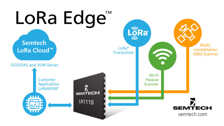
    Semtech Corporation, supplier of high-performance analog and mixed-signal semiconductors and advanced algorithms, has launched LoRa Edge, a versatile and low-power software defined LoRa-based platform.

    Semtech said LoRa Edge will enable a wide portfolio of applications for indoor and outdoor asset management, targeting industrial, building, home, agriculture, transportation and logistics markets.

    The first product from this portfolio is a geolocation solution for development of internet of things (IoT) devices for asset management applications. It features low-power Wi-Fi and GNSS sniffing capabilities combined with LoRa Cloud geolocation and device management services to significantly reduce the cost and complexity of locating and monitoring IoT assets.

    “Semtech continually delivers internet of things (IoT) solutions that simplify and accelerate the development of LPWAN applications,” said Pedro Pachuca, director of IoT Wireless in Semtech’s Wireless and Sensing Products Group. “LoRa Edge and LoRa Cloud geolocation services enable customers to develop ultra-low power applications for a variety of industries and will expand the mass adoption of LoRa in the IoT ecosystem.”

    Over the next decade, 500 billion devices are expected to connect to the internet (according to Cisco), as organizations continue to shift towards a more IoT-focused business strategy, and the majority of those IoT devices require some form of localization capability either at point of install or through the assets life.

    The LoRa Edge geolocation platform will enable solution providers to leverage the unique localization capabilities of LoRa as well as GNSS and Wi-Fi scanning capabilities from a single chip solution, allowing customers to choose the best localization tool for the application task they are addressing.

    By removing the need for incremental GNSS and Wi-Fi components, LoRa Edge reduces the bill of material (BOM) costs of devices and significantly reduces design and procurement complexity, Semtech said.

    The first LoRa Edge chipset targeted with geolocation (LR1110) is available today; more products from this portfolio will be released in the first half of this year.

    Product Features

    Multi-Purpose Radio Front-End

    • 150 – 2700 MHz continuous frequency synthesizer range
    • GPS/BeiDou scanning
    • Wi-Fi passive scanning

    Low-Power LoRa/(G)FSK RF Transceiver

    • Worldwide frequency bands support in the range 150 – 960 MHz
    • High power PA path +22 dBm
    • High efficiency PA path +15 dBm
    • Fully compatible with the LoRaWAN standard

    Cryptographic Engine

    • Hardware support for AES-128 encryption/decryption based algorithms
    • Handling device parameters such as DevEUI and JoinEUI
    • Protects confidential information such as encryption keys
    • Stores NwkKey, AppKey, as defined in the LoRaWAN standard
  • Quectel collaborates with Microsoft and Qualcomm on IoT solutions

    Quectel collaborates with Microsoft and Qualcomm on IoT solutions

    Photo: Quectel
    Photo: Quectel

    Quectel Wireless Solutions is collaborating with Microsoft and Qualcomm Technologies to integrate its new LPWA module BG95 with Microsoft’s Azure Device SDK.

    The integration will provide direct and secure connections to Azure IoT Hub and provide full support for Azure device management capabilities.

    Targeting global markets, the BG95 module is a cost-optimized, highly-integrated variant supporting integrated GNSS, Cat M1, Cat NB2 and EGPRS (also called EDGE). The module complies with 3GPP Release 14 and delivers improved capabilities in power consumption, data rates and hardware-based security.

    The BG95 cellular module is based on the Qualcomm 9205 LTE modem, to be integrated with Microsoft’s Azure Device software development kit (SDK). As a result, customers can connect their BG95 devices to the Microsoft Azure cloud where they can build, manage and deploy internet of things (IoT) solutions at scale, significantly accelerating time to market.

    By integrating RAM/flash, an ARM Cortex A7 processor supporting ThreadX, the BG95 is engineered to reduce power consumption significantly in idle mode.

    By doing this, the BG95 has the potential to support decade-plus battery life, which is critical for IoT devices serving long life spans, such as asset trackers, smart meters, smart city sensors, home security and wearable trackers.

    Additionally, Azure IoT is built for security. It simplifies the complexity of IoT security solutions with built-in protection at each stage of deployment (including cloud services and devices) and minimizes security weaknesses wherever they exist. Leveraging Azure IoT security features, Quectel BG95 will offer IoT devices end-to-end security capability in order to prevent potential risks.

    “We’re excited for the Azure edge device ecosystem to continue to grow. Our partnership with Quectel and Qualcomm Technologies will deliver what our customers need — bringing together ultra-low power cellular modules and Azure to drive their digital transformation,” said Roanne Sones, corporate vice president at Microsoft.

    “The BG95 module is the first Qualcomm 9205 platform to support IoT Plug and Play, accelerating LPWAN solution deployments like smart meters and asset trackers that connect seamlessly to our IoT Central offering,” Sones said.

    “With its cutting-edge performance and power-saving capabilities, the Qualcomm 9205 LTE Modem is the gold standard for multimode IoT modules looking to offer NB-IoT, Cat-M1, GPRS, and GNSS connectivity,” said Jeffery Torrance, vice president, business development, Qualcomm Technologies, Inc. “We are proud to continue our long-standing collaboration with Quectel to jointly drive the IoT forward.”

    “We are happy that the BG95-M3 has been verified on Microsoft Azure IoT Plug and Play. This validates our ability to jumpstart customers’ IoT projects with pre-tested modules and operating system combinations. Leveraging our close relationship with Microsoft and Qualcomm Technologies, we will jointly provide more integral ‘Device-Cloud’ solutions to customers,” said Doron Zhang, Chief Operation Officer, Quectel. “As one of the first wave Azure IoT PnP partners, Quectel has worked with Microsoft on LTE Mobile Broadband (MBB) modules, which have been widely adopted by top laptop OEMs. In the future, we will extend the partnership to more fields, such as Artificial Intelligence (AI) and Intelligent Edge, in order to help the Microsoft partner ecosystem connect their devices even more intelligently.”

  • Robotic Research to start testing fully autonomous unmanned shuttles

    Robotic Research to start testing fully autonomous unmanned shuttles

    Robotic Research logoRobotic Research LLC, a leading provider of autonomy and robotic technologies, will begin testing fully autonomous low-speed shuttles that are totally unmanned in the second quarter of this year.

    Current commercial applications of low-speed shuttles use onboard safety attendants to monitor the safety inside and outside the vehicle. Robotic Research plans to start testing without onboard attendants.

    The first step is to have the attendants in fixed on-site locations, with the future goal to move attendants to an offsite safety monitoring facility.

    “Through our work with the U.S. government over the past four years, we have already demonstrated that fully autonomous trucks are a reality. We are committed to making our shuttle and bus manufacturing partners successful by accelerating state-of-the-art technologies for unmanned vehicles ahead of regulatory agencies’ progress,” said Alberto Lacaze, president of Robotic Research.

    “The level of safety certification and redundancy necessary to drive fully autonomous vehicles is a significant undertaking that needs to be designed from the top down. Just adding more ADAS is not a reasonable or cost-effective pathway to full autonomy,” Lacaze said. “The advancements driven by the Robotic Research team will provide a product that significantly reduces the cost of operation and therefore improves market size.”

    Current local, state and federal regulations for most commercial shuttle operations require the safety attendant to be inside the cab of the vehicle. However, many transit operators are seeking to change these regulations to allow remote attendants to oversee system safety operations. The change is integral to the viability of low-speed shuttles, which are an innovative solution to the first/last mile problem, which is the distance between a traveler’s origin or destination, and a transit station or stop.

    Robotic Research has been developing and testing unmanned, autonomous operations for a wide range of vehicles for nearly a decade. The company currently provides autonomy kits that fully automate logistics convoy trucks for the U.S. government and several of its allied nation partners. Nearly 100 trucks have already been delivered. The tests for these vehicles have included operations with no safety attendants on board, with a single operator monitoring three unmanned vehicles.

    Robotic Research’s AutoDrive autonomy kit is platform agnostic and can be retrofitted to vehicles of all sizes, from small, portable robots to large trucks and buses. The system provides autonomous functionality on surfaces ranging from urban-improved roads to off-road terrain, all while the vehicle is collecting and analyzing data to better enhance the future of autonomous vehicles and transportation.

    Robotic Research’s technology provides automation to one of the largest international shuttle providers as well as to the largest U.S. manufacturer of commercial buses. The company’s AutoDrive kit also supports various autonomy programs in commercial and government sectors and is currently operating in communities and cities around the globe, including 30 states and four continents.

  • Lidar USA completes integration of Optech CL-360

    Lidar USA completes integration of Optech CL-360

    The Snoopy CL-360 lidar scanner. (Photo: Lidar USA)
    The Snoopy CL-360 lidar scanner. (Photo: Lidar USA)

    The Optech CL-360 has joined the ranks of Lidar USA Snoopy systems.

    The Snoopy CL-360 has been meticulously designed for integration on backpack, vehicle and UAV applications. Weighing 5 kilograms fully assembled, the Snoopy CL-360 is capable of delivering highly accurate results, up to +/-0.01 feet on paved surfaces from a vehicle.

    The system has a scan line rate of 250 Hz with a 500-kHz data rate, giving a uniform result along and across track. The systems are easily configurable with multiple scanners (similar to internet of things applications) to avoid occlusions.

    “We are pleased to again partner with LidarUSA in their innovative approach to UAV integration with the addition of our CL-360 to their product portfolio. Featuring true 360-degree scanning without blind spots, CL-360 integrated by LidarUSA will provide an exciting addition to the UAV marketplace,” said Optech Executive Vice President and General Manager Michel Stanier.

    Users can also benefit from a UAV deployment, achieving scans with usable data as much as 60 degrees off nadir (widths of more than 1,100 feet while scanning at the 400-foot ceiling). The small beam size of 0.3 mrad allows the CL-series to reliably collect ground points (such as on or near the dirt through vegetation) while also providing better detection of fine linear features such as power lines and railroad tracks.

    The integration of the CL-360 into the Snoopy series of systems from Lidar USA is expected to be a huge plus to the mapping community in 2020, according to Lidar USA. Users can expect to see the benefit of decreased field-collection effort and increased product quality resulting in a growing and profitable business.

    “As more technologies embrace lidar collection to reduce their field time, we expect to see the CL-series become the ‘go to’ solution for many of them,” said Jeff Fagerman of Lidar USA. “The CL-series provides the accuracy and point density often necessary to meet the client’s every growing demands for more, more, more. By designing the system for car and UAV, as well as multiple configurations (two or more systems running together), our users will greatly benefit where they feel it most — the bank.”

  • L3Harris passes design review for NTS-3 navigation satellite

    L3Harris passes design review for NTS-3 navigation satellite

    L3Harris Technologies has reached a major milestone in the U.S. Air Force’s Navigation Technology Satellite-3 (NTS-3) project — passing the preliminary design review that defines the spacecraft’s path to delivery and allows the program to move to the next phase of development.

    NTS-3 is an experimental program examining ways to improve the resiliency of the military’s positioning, navigation and timing capabilities. It will also develop key technologies relevant to the Global Positioning System (GPS) constellation, with the goal of future transition to the GPS IIIF program.

    In collaboration with the Air Force Research Laboratory, Space and Missile Systems Center, and United States Space Force, L3Harris is combining experimental antennas, flexible and secure signals, increased automation, and use of commercial command and control assets.

    Satellite NTS-3 closeup. (Illustration: Lt. Jacob Lutz, AFRL Space Vehicles Directorate)
    Satellite NTS-3 closeup. (Illustration: Lt. Jacob Lutz, AFRL Space Vehicles Directorate)

    “The NTS-3 vanguard is an experimental, end-to-end demonstration of agile, resilient space-based positioning, navigation, and timing,” said Arlen Biersgreen, Air Force NTS-3 program manager. “It has the potential for game-changing advancements to the way the Air Force provides these critical capabilities to warfighters across the Department of Defense. The commitment demonstrated by United States Space Force to partner with AFRL and support technology transition was a key element in NTS-3 being designated as an Air Force vanguard in September 2019.”

    The Space Enterprise Consortium selected L3Harris for the $84-million contract in 2018 as the prime system integrator to design, develop, integrate and test NTS-3, including ground mission applications.

    “We have moved from contract award to finishing an early design review in under one year, which is an amazing accomplishment for a satellite development program that normally takes twice that amount of time,” said Ed Zoiss, President, Space and Airborne Systems, L3Harris. “We have proven we can move quickly to support the Air Force’s go-fast mission requirements.”

    L3Harris has more than 40 years of experience transmitting GPS navigation signals. The company’s technology has been onboard every GPS satellite ever launched.

  • Turkish satnav station opens in Antarctica

    Turkish satnav station opens in Antarctica

    Turkey has opened GNSS base station in Antarctica, according to Sputnik News. The station can track changes in the location of icebergs and transmit photos of Antarctica’s surface, as well as process data from GPS, GLONASS and Galileo.

    “A GNSS satellite navigation base station was set up within the framework of the fourth Turkish scientific expedition to Antarctica,” said Turkish Industry and Technology Minister Mustafa Varank, as quoted by the national Anadolu news agency. “A group of specialists from the Turkish General Directorate of Mapping has built Turkey’s first GNSS base station abroad.”

    The Fourth Antarctic Expedition of Turkey began on Feb. 9 under the coordination of the Scientific and Technological Research Council (TUBITAK) Polar Research Institute. The GNSS station operates on Dismal Island, 73 kilometres (45 miles) from Horseshoe Island, where the temporary Turkish science base is located.

    The 24-member Turkish research team joins 15 scientific projects in the Earth, life, and marine sciences. The expedition is being conducted under the auspices of the Turkish Presidential Administration and the Ministry of Industry and Technology and coordinated by the TUBITAK.

  • PNT Executive Order helpful, but delays market solutions

    PNT Executive Order helpful, but delays market solutions

    Headshot: Dana Goward
    Dana Goward, President, Resilient PNT Foundation

    On Feb. 12, the White House released an “Executive Order on Strengthening National Resilience through Responsible Use of Positioning, Navigation, and Timing Services.”

    It is gratifying to see White House attention to this issue. The increase in public awareness it brings will benefit individual users and the nation as a whole.

    The order also hints at market driven solutions that could quickly improve America’s PNT resilience.

    Needless delays

    Unfortunately, the order fails to direct immediate action on this critical national and economic security issue. Instead it needlessly pushes most action and responsibility off for a year or more to do “more study.”

    This is hard to understand as most of the “more study” has already been completed. For example, the order tells the Department of Commerce to take up to a year to examine PNT use in various sectors, and identify vulnerabilities and user needs. The Department of Homeland Security has already completed a National Risk Assessment and, according to congressional staff, has recently completed a report on user requirements mandated in 2017’s National Defense Authorization Act.

    The Office of Science and Technology Policy is given a year to develop a plan to test robust and resilient non-GNSS PNT services (but is not required to actually do any testing). Congress mandated such a test program in 2017 and funded it with $10 million in 2018. After much delay, the Department of Transportation will complete the testing in May of this year.

    The order gives the Department of Commerce six months to make available a time source to support critical infrastructure. For more than 60 years, the nation’s master clock has been available to users at the department’s NIST Laboratory in Boulder, Colorado.

    Note the challenge has not been the clock, but that the nation has no way — other than vulnerable GPS signals — to distribute time at the needed level of accuracy to millions of critical infrastructure nodes. Government studies in 2007 and 2014 determined that the best way to do this was with a ground-based system. The Department of Transportation’s ongoing testing program is examining this issue again.

    Market-driven solutions

    Aside from increasing public awareness, the best thing the Executive Order does is to point a way forward for market-driven resilient PNT solutions.

    The order calls for federal contracts to (in 21 months, if everyone does their jobs on time) require that vendors use existing and new resilient PNT sources.

    If this eventually happens, the government could leverage its enormous influence in the market and stimulate creation of one or more commercial distribution systems for resilient, non-GNSS PNT. This is a great concept, and very much in keeping with America’s tradition of letting market forces solve some of its biggest problems.

    But this solution will not spring into life on its own.

    No commercial entity will invest tens of millions of dollars, or more, in a PNT system without assurance in advance of an income stream. Especially since federal contracting officers can and will waive the requirement if offerors cannot reasonably meet it.

    If stimulating a market solution is the administration’s intent, it must stay actively involved and encourage the process for some time to come.

    This includes complying with the 2018 law that requires establishment of at least one wireless, terrestrial, difficult-to-disrupt source to back up the timing signals provided by GPS.

    Fortunately, this can be done by leveraging the free market at minimal cost and with little administrative effort.

    By contracting to subscribe to a commercial service that will provide resilient PNT signals, the government need only invest a relatively small yearly sum using a fairly simple contract vehicle. Such a contracting technique has been used before with great success.

    In 2007 the Federal Aviation Administration (FAA) did this as a way to establish its ADS-B aviation tracking and safety network. Once the subscription contract was let, the commercial provider was able to get financing and quickly build out the system.

    Today, the FAA gets the information it needs, doesn’t have the headache of owning and maintaining a large network, and even shares in the revenue the system owner earns from selling data to other companies.

    Additional leadership needed

    It is important to remember that, regardless of the issue, presidential pronouncements are not enough.

    In 2004, President G.W. Bush directed a number of actions to protect the nation’s critical PNT, including establishment of a GPS backup capability. While 16 years later his directive is still official executive branch policy, that mandate and many others from his order are still unexecuted.

    Real improvements to PNT resilience and our nation’s security depend not on one-time pronouncements, but continued leadership focus and engagement.

    This is always a challenge for initiatives driven by the White House. It will be doubly so in this case as there is no clear department leader for civil PNT issues the administration can rely on while it attends to the next issue of the day.

  • Timing center to protect UK from risk of satellite failure

    Timing center to protect UK from risk of satellite failure

    The UK’s emergency service responders and other critical services could be set for more resilient time systems through the National Timing Centre.

    The United Kingdom has established a new timing center to reduce reliance of public services and its economy on GNSS satellites. The center uses a network of atomic clocks housed at secure locations, and consists of a team of researchers based at sites across the U.K.

    The National Timing Centre will provide additional resilience for accurate timing, which underpins many everyday technologies including emergency response systems, 4G/5G mobile networks, communication and broadcast systems, transport, the stock exchange and the energy grid — all of which depend on precision timing from GNSS.

    A large-scale GPS failure would cause a £1 billion a day economic impact to the UK. Loss of this accurate data would also have severe and life-threatening effects, such as on getting ambulances to patients or getting power to homes around the country. The center’s land-based technologies will improve the UK’s resilience and provide important back-up.

    The UK’s current dependence on satellite technologies has been identified by the government as a potential security risk if a satellite were to experience a failure. The Blackett Review in 2018 looked at the UK’s vulnerabilities to over-reliance on Global Navigation Satellite Systems (GNSS).

    The Blackett Review, published in January 2018 by the UK Government Office for Science, identified an over-reliance on GNSS.

    National Timing Centre to add resilience

    The government is investing £36 million to create the National Timing Centre, which will ensure the UK economy and public services have additional resilience to the risk of satellite failure. The investment will build a resilient network of clocks across the UK. It includes £6.7 million which will be made available via Innovate UK funding calls to SMEs and industry to innovate around timing and clocks.

    Science Minister Amanda Solloway announced the center on Feb. 19. “Our economy relies on satellites for accurate timing,” she said. “Without satellites sending us timing signals, everything from the clocks and maps on our phones, to our emergency services and energy grid would be at risk. I’m delighted that this world-first centre will see our brightest minds, from Surrey to Strathclyde, working together to reduce the risks from satellite failure.”

    “The failure of these systems has been identified as a major risk, and The National Timing Centre programme will help to protect both vital services and the economy from the disruption this would cause while delivering considerable economic benefits,” said UK Research and Innovation Chief Executive Professor Sir Mark Walport.

    “We are proud to be leading the way in providing trusted and assured time and frequency,” said National Physical Laboratory CEO Pete Thompson. “The work undertaken by the team here has ensure the National Timing Centre programme will provide huge benefits to society, whilst underpinning secure applications in the future.”

    The center also includes researchers at the University of Birmingham, the University of Strathclyde, University of Surrey, BT Adastral Park, Suffolk, BBC, Manchester, and the National Physical Laboratory in Teddington.

    The £76 million investment furthers the government’s commitment to significantly boost R&D investment across every part of the UK, including funding transformational technologies and increasing the number of researchers.

    The funding is provided through the Strategic Priorities Fund, which supports high-quality discipline research and development priorities, with investment also going towards autonomous systems and national collections.

    Alongside investment in the new center, the UK government is investing a further £40 million in a new research programme, Quantum Technologies for Fundamental Physics.

    Total investment through the National Quantum Technologies Programme is set to pass £1 billion since its inception in 2014.

  • New Leica Nova MS60 enables surveying with one instrument

    New Leica Nova MS60 enables surveying with one instrument

    The new version of all-in-one MultiStation addresses a wide range of needs. (Phoeo: Leica Geosystems)
    The new version of all-in-one MultiStation addresses a wide range of needs. (Photo: Leica Geosystems)

    The new Nova MS60 MultiStation combines upgraded, faster 3D laser-scanning capabilities, GNSS connectivity and digital imaging with a high-end total station. According to Leica Geosystems, part of Hexagon, the multi-station brings sensor fusion to the “next level.”

    The MS60 features several laser scanning updates, including an fast scanning speed of up to 30,000 points per second, optimized scan area definitions, adapted scan managements, and an improved scanning path for zenith scans.

    It is also equipped with the unique AutoHeight feature, enabling users to save time by automatically measuring the instrument’s height with a simple button press. Measurement professionals can make decisions directly in the field, performing point-cloud analysis such as flatness analysis and as-built checks in the Inspect Surface app of the MS60.

    “Scan data combined with traditionally measured points, whether it’s from the total stations or the GPS receivers, is one of those immediate deliverables that help our clients see what we’re doing. With the scan data of the Leica Nova MS60 MultiStation, we can graphically show — the same day it is collecting — the locations in the field to any person,” said Donald Smith, senior land surveyor and principal at BL Companies. “When you deliver on time and provide customers with a deliverable they can see, you’ve just got yourself a recurring client.”

    The MS60 speeds up workflows by combining technologies in this all-in-one instrument. The MultiStation  total station offers advanced imaging, scanning capabilities and GNSS connectivity. With Leica Captivate field software, all measurement and scanning data can be visualized in 3D for quality and completeness checks.

    MS60 users can seamlessly transfer all data into Leica Infinity software to manage, process, analyze and perform a quality check. The MultiStation helps users deliver projects on time, save money and have high flexibility in the field.

    “The MS60 merges data in a multi-level process — total station measurements are complemented by 3D point clouds, which are automatically registered and coloured by the image information. All data perfectly fits within the same coordinate system, globally referenced by GNSS measurements or by measuring known points,” said Falko Henning, senior product manager at Leica Geosystems.

    “Unlike other measurement devices, the MS60 offers familiar total station capabilities and scanning functionality to fulfil job requirements on site.” Henning said. “The operator can use the red laser pointer to perform reflectorless measurements for direct remedial work on-site or stakeout points and use the field controller even while a scan is performed.”

  • Apple applies for machine learning GNSS device

    Apple applies for machine learning GNSS device

    Logo: Apple

    Earlier this month, Apple applied to the Federal Communications Commission for to a license to install GPS testing equipment on its headquarters campus.

    This may be related to an application filed by Apple Inc. with the U.S. Patent Office in August 2019, which describes the company’s “Machine Learning Assisted Satellite Based Positioning.”

    From the patent application:

    MACHINE LEARNING ASSISTED SATELLITE BASED POSITIONING

    A device implementing a system for estimating device location includes at least one processor configured to receive an estimated position based on a positioning system comprising a Global Navigation Satellite System (GNSS) satellite, and receive a set of parameters associated with the estimated position.

    The processor is further configured to apply the set of parameters and the estimated position to a machine learning model, the machine learning model having been trained based at least on a position of a receiving device relative to the GNSS satellite.

    The processor is further configured to provide the estimated position and an output of the machine learning model to a Kalman filter, and provide an estimated device location based on an output of the Kalman filter.

    In 2015, Apple acquired the small enhanced-GPS company Coherent to aid the speed and accuracy of its devices’ location services. Presumably, Apple intends to incorporate its machine-learning positioning method into its navigation software.

  • EGNOS payload enters service on Eutelsat 5 West B

    EGNOS payload enters service on Eutelsat 5 West B

    The EGNOS payload aboard the Eutelsat 5 West B satellite has entered service, according to Eutelsat Communications. The satellite carries a payload for the European GNSS Agency (GSA) called GEO-3. GEO-3 is designed to be aboard a geostationary satellite to augment GNSS signals.

    A solar-array problem affected the satellite shortly after its Oct. 9 launch.

    Eutelsat 5 West B is hosting the EGNOS payload under a 15-year agreement signed in 2017 with the European GNSS Agency (GSA). The contract also includes technical services and a European ground infrastructure, including two gateways installed at Eutelsat’s Rambouillet and Cagliari teleports.

    Image: GSA
    Image: GSA

    “Eutelsat is proud of the collaboration with its customer GSA, its partners including the European Space Agency, and its suppliers, culminating in the entry into service of this next generation technology of EGNOS on Eutelsat 5 West B,” said Yohann Leroy, Eutelsat’s Deputy CEO and Chief Technical Officer. “We are delighted to host this payload, which will significantly enhance the performance of global navigation satellite systems across Europe, notably Galileo, in the coming years.”

    “With this new payload in service, EGNOS is moving towards the transition to its new generation,” said Pascal Claudel, GSA acting executive director and CEO. “This has been done thanks to the constructive collaboration with Eutelsat. Delivery and continuity of satellite services are part of our mission as delegated by the European Commission. It is essential that we, at the GSA, ensure these services to support economic growth and that the European Union’s citizens and companies can benefit from the latest GNSS technology.”

  • 1Spatial forms strategic partnership with Neueda

    1Spatial forms strategic partnership with Neueda

    Duncan Guthrie (left) of 1Spatial and Peter Russell of Neueda. (Photo: 1Spatial)
    Duncan Guthrie (left) of 1Spatial and Peter Russell of Neueda. (Photo: 1Spatial)

    1Spatial has formed a strategic partnership with international technology company Neueda. 1Spatial and Neueda will jointly provide digital solutions that enable customers to transform and improve the way they do business.

    1Spatial is a software solutions provider and global expert in managing location and geospatial data.

    Neueda provides digital transformation services to customers in the private sector, public sector and capital markets across the globe. Headquartered in Belfast, Neueda has bases in Dublin, London, Malaga and New York.

    As a software solutions provider and global experts in managing location and geospatial data, 1Spatial will complement Neueda’s services by provisioning geospatial digital services that support customer transformation and improvement projects.

    “We are excited to announce this partnership with Neueda and really look forward to working together with their highly talented specialists,” said Duncan Guthrie, managing director, 1Spatial. “We both have a similar approach with our customers and always ensure we deliver the best solutions to meet their business needs. Through this partnership we look forward to delivering success for our customers and helping them unlock the value of their spatial data.”

    “We are delighted to formally partner with 1Spatial and look forward to working with a global leader in geospatial data,” said Peter Russell, managing director, Enterprise Services, Neueda. “Neueda sees data as a key enabler to true digital transformation and geospatial data is certainly a key challenge for many of our customers. We hope this partnership will also allow us to develop joint propositions to break into new markets.”