Rx Networks Inc., as part of its continued reference network expansion and vendor diversity initiative, has added BeiDou III B1C and B2a signals and messages to Location.io, its feature-rich, modular location platform.
BDS III is available via Location.io in a variety of data formats including regionally optimized, NTRIP, LPP and RRLP, as well as proprietary real-time and predicted formats.
With the addition of BDS III, Location.io is positioned to support mobile devices globally in any configuration, including dual-band or single-band GNSS receivers, and in single or multi-constellation configurations.
“Rx Networks continues to follow up on our promise to deliver Location. Enlightened. products and services,” said Peter Mueller, head of innovation at Rx Networks. “BDS will play a major role in the years to come with the uptake of multiband GNSS in mobile devices including smartphones and internet of things (IoT) devices.”
“The upgrade and expansion of our private global reference network can now offer legacy BDS II signal B1I right up to PRN 63, in addition to the new BDS III B1C and B2a signals, as well as GPS/QZSS/Galileo/GLONASS/NavIC support in L1, L2c and L5/E5. Plus, our network is ready for Galileo E6. This makes Location.io one of the most complete data services available, all with a great Service Level Agreement.”
BDS III will be part of the Location.io software client in early 2020.
Location.io technologies are in use by more than 2 billion smartphones, laptops and wearables worldwide. All Location.io services are delivered from Rx Networks’ geo-redundant and cloud-based service delivery network, ensuring 99.999% service-level availability.
Companies aim to provide sub-lane-level accuracy to automotive OEMs and Tier 1 suppliers
Image: Trimble
Trimble and Qualcomm Technologies, a subsidiary of Qualcomm Inc., will be working together to produce precise-positioning solutions for select automotive applications.
Trimble will work with Qualcomm Technologies to integrate Trimble’s RTX technology with select Qualcomm Snapdragon Automotive 4G and 5G platforms to deliver a highly accurate positioning solution essential for maintaining absolute in-lane positioning.
The new solution will accelerate the adoption of road-level navigation and emergency services applications, as well as satisfy requirements for developing advanced driver-assistance systems (ADAS) and autonomous driving solutions.
The Snapdragon 4G and 5G automotive platforms feature integrated multi-frequency and multi-constellation high-precision GNSS technology. They also support all major global and regional GNSS satellite constellations including GPS, GLONASS, Galileo, BeiDou, and QZSS, operating concurrently on the L1, L2, and L5 frequency bands, including a precise positioning framework.
The framework ensures consistency in access and use of precise positioning information and incorporates the use of GNSS corrections technology.
Tight integration of GNSS functionality in conjunction with the modem reception of the corrections allows for minimum latencies and optimal performance of the precise-positioning solution from the telematics system and provides automakers with a global location platform to meet the requirements of next-generation vehicles.
Trimble RTX technology provides real-time, multi-constellation GNSS corrections and positioning capable of achieving 2-centimeter horizontal accuracy worldwide, compared to uncorrected GNSS positioning that can be accurate to several meters. The combined solution will provide reliable, consistent, high-accuracy positioning, in a broadcast format, to serve even the most precise requirements of the automotive and transportation industries.
“Trimble’s relationship with Qualcomm Technologies establishes a unique alliance between industry leaders, in which both companies are committed to advancing the development of safer, more capable ADAS,” said John Sprivulis, director of autonomous navigation solutions for Trimble’s advanced positioning division. “Together we will offer a solution to the automotive industry that can help accelerate the adoption of precise GNSS positioning in the connected car and transform the way the world drives.”
“Highly accurate positioning is quickly becoming an important element of connected vehicle solutions to support Vehicle-to-Everything (V2X) and other autonomy applications,” said Lars Boeryd, senior director, product marketing, Qualcomm Technologies. “For this very reason, we are working with Trimble to host the RTX precise positioning software library on our Snapdragon Automotive 4G and 5G platforms to offer a robust end-to-end highly accurate position solution for the automotive industry.”
Evaluation kit. An RTX-enabled Snapdragon evaluation kit (EVK) is expected to be available by early 2020, for use by automotive OEMs, Tier 1 suppliers or other stakeholders considering absolute positioning as part of their autonomy solution.
Trimble has also made Trimble RTX Auto an ASIL and ASPICE compliant RTX software library, available to any OEM or supplier who requires a functional safety certified solution.
QinetiQ and its partner Collins Aerospace have won a £67 million contract with the United Kingdom’s Ministry of Defence (MOD) Defence Equipment and Support (DE&S) to develop multi-constellation satellite receivers under the U.K. Robust Global Navigation System (R-GNS) program.
The program will deliver critical capability to provide UK Defence with accurate and resilient positioning, navigation and timing (PNT), which will underpin the UK’s ability to undertake 24/7 military operations around the world in demanding and increasingly contested operational environments.
QinetiQ, working with its partner (Collins Aerospace) and sub-contractors (Roke Manor Research, Raytheon Systems Limited, Garfield Microelectronics, Nottingham Scientific Limited, Phixos and a number of other specialist suppliers and manufacturing partners) will work together to provide advanced navigation products that are UK sovereign supplied, low size, weight and power (SWAP) delivering high-accuracy, resilient and secured operational capability.
The use of multi-constellation, multi-service satellite navigation signals, multiple sensors and QinetiQ’s advanced processing technologies will enable secured navigation, ensuring that users and platforms —autonomous land, maritime, air and weapons systems — will be able to navigate accurately, robustly and safely.
“Whether it’s soldiers conducting operations in remote environments or fighter jet pilots flying in contested airspace, our Armed Forces depend on satellite navigation technology,” said Defence Minister Anne-Marie Trevelyan. “These state-of-the-art receivers will help to ensure our armed forces can defend UK interests wherever and whenever they are threatened.”
“Ensuring that UK Forces have the best and most resilient secured navigation capabilities is essential to ensuring that they are able to operate effectively in increasingly challenging operational environments,” Steve Wadey, CEO, QinetiQ said. “We are extremely pleased to be working with MOD, DE&S and DSTL to deliver this critical capability. This programme will exploit QinetiQ’s advanced technologies and, working collaboratively with our partners across the supply base, deliver substantial operational advantage for UK Defence.”
The delivery date for the first R-GNS products is February 2022.
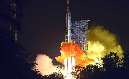
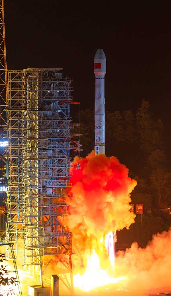
China has launched two more BeiDou III satellites. The launch took place on Sunday, Sept. 22, using a Long March 3B rocket which lifted off from the Xichang space center at 2110 GMT (5:10 p.m. EDT), according to the Xinhua News Agency.
About four hours after liftoff, the upper stage delivered the Beidou satellites into a nearly circular orbit with an average altitude of 13,500 miles (21,800 kilometers) and an inclination of 55 degrees.
The satellites were produced by the China Academy of Space Technology, a government-owned satellite builder.
With Sunday’s launch, China has added five new satellites to the Beidou network this year, halfway to its stated goal of 10 Beidou satellites this year.
The satellites are the 47th and 48th spacecraft launched in the Beidou navigation program.
Lidar USA has become the Titanium sponsor for the first UAS Rodeo, hosted by GEOHuntsville out of Hunstville, Alabama.
Operating since 1999, Lidar USA offers unmanned aerial vehicle (UAV) and mobile mapping systems for scanning, imaging and navigation.
Its products will be on display at the UAS Rodeo, which is designed to give Part 107 UAS pilots involved in public safety activities a full-scale training, skill-building and competitive environment to share knowledge in UAS operations.
The company said that integrating its mobile mapping solutions with the rapidly growing UAV industry has been pivotal to its success to adapt to a customer’s needs. UAS Rodeo will provide Lidar USA an avenue to show the UAS community its cutting-edge technology.
The UAS Rodeo takes place Oct. 9-10 in Huntsville at the Public Safety Training Academy, 6001 Cecil Fain Drive NW.
Digital Matter’s Oyster2 4G battery-powered GPS receives PTCRB approval, AT&T certification and redesigned housing
Digital Matter’sOyster2 is now PTCRB approved and certified for use on the AT&T Network in the United States. With PTCRB certification, operators and device manufacturers are confident of a device’s interoperability with mobile networks.
Designed for tracking non-powered assets for extended periods of time, common applications of the Oyster2 include tracking trailers, bins, hire and rental equipment, shipping containers, boats, bikes, scooters and more.
The Oyster2’s u-blox SARA-R410M modem operates on all major global LTE-Cat-M1 and NB-IoT bands. The device uses concurrent GPS and GLONASS tracking with a 72-channel high sensitivity receiver, and features a 3D accelerometer for G-force detection.
Configurable adaptive-tracking parameters allow the device to sleep when stationary, resulting in industry-leading battery life: up to seven years of life at once daily updates; one year of life at once hourly updates.
The versatile asset tracker can be powered by three off-the-shelf AA lithium batteries, or lithium thionyl chloride (LTC) batteries for enhanced performance and temperature tolerance.
The Oyster2 is now also available in redesigned ultra-rugged housing. Engineered with nylon glass, the IP67 housing is considerably tougher and thicker in key areas, providing increased durability, thermal resistance (the device can reach temperatures up to 185º F/85º C without compromising performance) and chemical resistance.
The device’s mounting tabs and screw holes have also been fortified and repositioned, improving resistance to cracking.
Digital Matter is an original equipment manufacturer of award-winning GPS and internet of things (IoT) devices and tracking software. Digital Matter devices are resold through 500 channel partners across the world and deployed in more than 110 countries.
Raytheon’s F-35 precision landing system can be set up anywhere in less than 1.5 hours
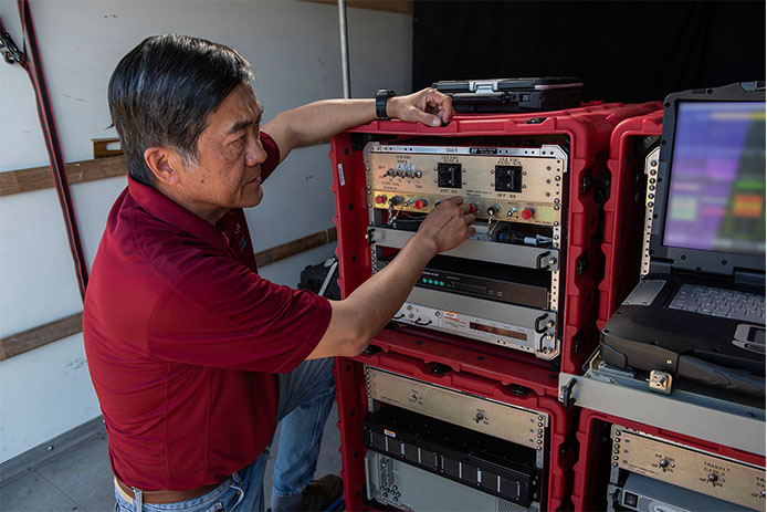
A Raytheon Company team has conducted a rapid set-up demonstration of a land-based expeditionary version of its Joint Precision Approach and Landing System (JPALS) to a group of global military officials at Naval Air Station Patuxent River, Maryland.
JPALS is a GPS-based precision landing system that guides aircraft to precision landings in all weather and surfaces conditions.
“The entire system was fully operational in 70 minutes on Day One and 50 minutes on Day Two,” said Matt Gilligan, vice president at Raytheon’s Intelligence, Information and Services business. “Raytheon is offering the U.S. and its allies fast and accurate precision landing systems that support operations from bare-base locations.”
During the demonstration, military officials from all four services, as well as representatives from Japan, United Kingdom, The Netherlands and Italy, watched multiple F-35Cs land on the same designated runway landing point every time over the course of six different approaches.
This was the second proof-of-concept event in 2019 showing how F-35s can use a reconfigured mobile version of JPALS to support landings in austere environments.
JPALS is a differential, GPS-based precision landing system that guides aircraft onto carriers and amphibious assault ships in all weather and surface conditions up to the rough waters of Sea State 5. It uses an encrypted, jam-proof data link to connect to software and receiver hardware on the aircraft and an array of GPS sensors, mast-mounted antennas and shipboard equipment.
A Raytheon technician operates the rapidly installed JPALS equipment during a demonstration at the Naval Air Station. (Photo: Raytheon)
Rx Networks Inc., a mobile location technology and services company, has announced support for the NavIC Constellation.
The company made the announcement at ION GNSS+, held earlier this month in Miami, Florida.
Rx Networks’ comprehensive GNSS constellation data service provides technology partners — and their associated customers — real-time and predicted assistance for all satellite navigation systems and L1 satellite-based augmentation systems (SBAS) for any region around the globe.
The addition of NavIC builds on Rx Networks’ brand promise (to deliver “location enlightened” products and services) by providing real-time and predicted GNSS assistance data in any individual or combination of formats. This enables developers to optimize device performance for specific use cases and conform to national requirements.
Data is delivered via ephemeris in RINEX and Predictions in SP3, P-GNSS and RT-GNSS, via the Location.io platform, will be added in the first quarter of 2020.
“Our Location. Enlightened. brand promise speaks to our goal of providing the most comprehensive, relevant, accurate and reliable location data available,” said John Carley, vice president of sales and marketing at Rx Networks. “The addition of NavIC in our carrier-grade infrastructure demonstrates our commitment to our brand and to stay on the leading edge of truly global satellite-based positioning and services. The ability to offer NavIC support is extremely significant as it ensures we can support our customers with exactly what is required in any given region of the Globe.”
NavIC, formerly known as IRNSS (Indian Regional Navigation Satellite System), combines GEO and IGSO satellites to provide a regional position, navigation and time (PNT) system including ionospheric corrections.
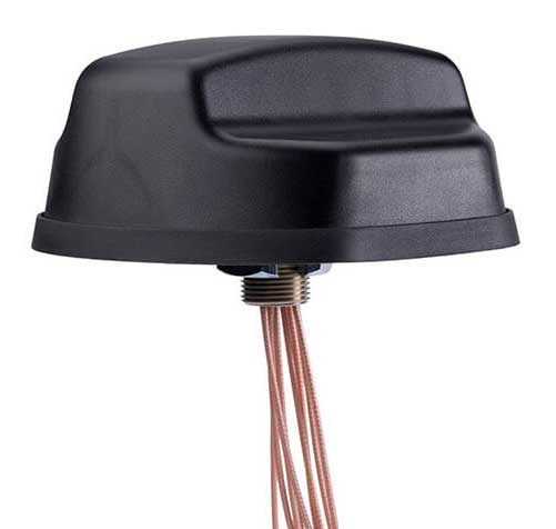
PCTEL Inc. has released an antenna that combines precision multi-constellation GNSS with high-performance LTE, sub-6 GHz 5G, Bluetooth and Wi-Fi connectivity.
The Coach II antenna with GNSS L1/L2/L5 is designed to provide greater precision and reliability for advanced rail communications systems, enabling everything from next-generation positive train control (PTC) to passenger Wi-Fi.
“Precise timing and tracking information is critical not just for rail, but for a variety of fleet, public safety, and industrial IoT [internet of things] applications,” said Rishi Bharadwaj, PCTEL’s chief operating officer. “PCTEL’s antenna technology enables our customers to deploy new technologies with confidence,” added Bharadwaj.
PCTEL is displaying its Coach II antenna with GNSS L1/L2/L5 on Sept. 22-24 at RSSI C&S Exhibition in Minneapolis, Minn. It is available to order now for shipment in early November using part #GL125-DLTEMIMO.
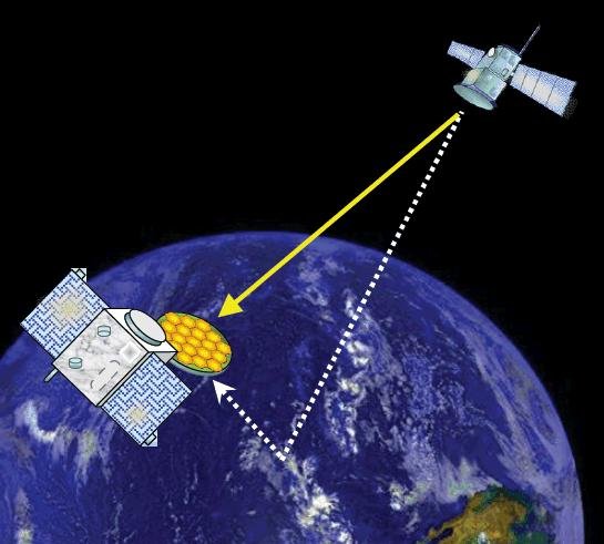
Your phone or satnav receiver routinely picks up signals from navigation satellites in order to tell you precisely where you are. But have you ever thought what happens to those satnav signals afterwards? A foresighted ESA inventor had the idea of using them as a tool for observing the Earth.
More than 120 satellite navigation satellites are in orbit, making up multiple constellations including Europe’s Galileo system, sending down a continuous rain of satnav signals for the benefit of users worldwide. Just like visible light, these microwave signals go on to reflect off Earth’s land and sea surfaces.
The traditional attitude to these reflected signals is to see them as something of a nuisance — known as multipath, they can confuse satnav receivers and reduce their overall accuracy.
ESA microwave engineer Manuel Martín-Neira, inventor of the PARIS reflectometry concept. (Photo: ESA)
But back in 1993 — at the same time as the US GPS satnav system reached its full constellation of 24 satellites — a young ESA microwave engineer called Manuel Martín-Neira came up with the idea of treating these satnav reflections as a scientific resource instead.
“My head of division asked me to come up with a budget-friendly way of increasing the overall sampling rate to build up a fuller picture of mesoscale phenomena, and that led me to start looking into making use of additional signals of opportunity, chiefly satnav signals.
“The initial reaction was mixed, because the forecast accuracy was not as precise as the ERS-1 altimeter could deliver — but on the plus side there would be a lot of these signals to make use of, and the performance has improved a lot since those early days.”
PARIS, detecting reflected satnav. (Photo: ESA)
Inspiration from reflection
The basic idea of what Manuel christened the Passive Reflectometry and Interferometry System, or PARIS, comes down to a two-sided antenna. As the topmost side picks up a satnav signal from the satellites in orbit, the other side picks up the version of the signal bounced back from Earth.
By comparing this initial, overhead signal with its reflected equivalent using a process called interferometry — measuring tiny differences in signal phases – the extra travel time of this reflected beam can be determined, down to an accuracy of less than five centimetres, determining sea height and sea ice thickness.
Additional amplitude waveform processing can deliver further data on wind and wave measurements over the ocean, and soil moisture and biomass over land.
Satellite reflectometry has since grown into a thriving field. This summer, Manuel attended the latest international workshop on the method he first devised 26 years ago.
Reflectometry reaches space
“It’s been fantastic to have experimental evidence, and that’s really been made possible by the growing availability of smaller satellites,” explains Manuel.
“Because satellite reflectometry is a passive form of remote sensing, it makes for an attractive potential payload because it doesn’t need a lot of power to operate. Then one of the results is meteorology data that private companies intend to make money with by delivering to public agencies.”
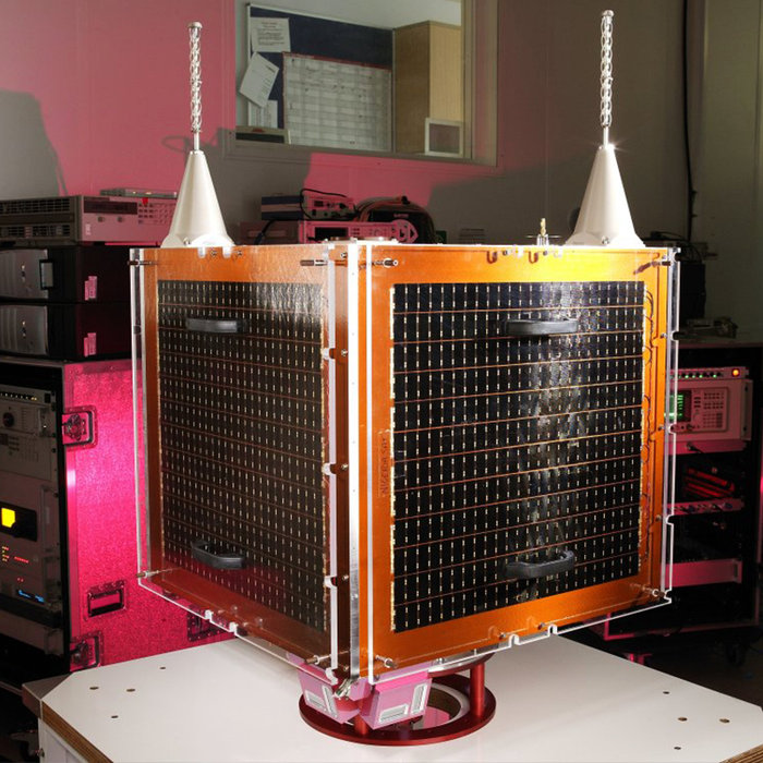
Surrey Satellite Technology Ltd.’s UK-DMC satellite was the first orbital mission with a reflectometry payload. (Photo: ESA)
In 2003, the UK-DMC satellite was the first mission to fly a reflectometry payload, followed in recent years by, for example, the UK’s TechDemoSat-1, NASA’s CyGNSS constellation to monitor hurricanes and the Spire global constellation of commercial nanosatellites.
“These satellites have really given the reflectometry community a wealth of signals, demonstrating what reflections look like over different surfaces including sea ice, forests, and even inland water bodies such as the Amazon River and its tributaries.
“In parts of the ocean near continental masses and within atolls we are seeing reflected signals from very calm waters which resembled a mirror, giving us very high precision down to 1 cm level. Such measurements could potentially complement current altimetry missions, by for instance measuring sea level rise.”
Example of a CYGNSS Microsatellite Observatory. (Image: Southwest Research Institute)
ESA activities taking flight
ESA meanwhile is active on reflectometry in various ways, having developed and tested a steerable airborne antenna called the Software PARIS Interferometric Receiver or SPIR, capable of steering separate antenna beams to build up a rapid surface picture, and differentiating between different signal sources, such as GPS from Galileo.
Manuel adds: “ESA’s GNSS Science Support Centre, based at the Agency’s European Space Astronomy Centre near Madrid, has been taking a keen interest in these activities.”
Missions are also in development, including a dedicated CubeSat with RUAG-Austria and the University of Graz called PRETTY (for Passive REflecTomeTry and dosimetry, which would also carry a radiation detector), and a small satellite pair called FSSCat from Spain’s Universitat Politècnica de Catalunya, backed through the Copernicus Masters competition, seen as a prototype for a future reflectometry constellation.
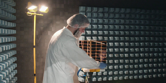
ESA’s Directorate of Telecommunications and Integrated Applications is also working with the Spire company to fly enhanced reflectometry instruments, starting at the end of this year.
One of Spire’s Satellite Manufacturing Technicians (Tomasz Chanusiak) tests the Radio Frequency capabilities of a LEMUR2 nanosatellite in Spire’s cleanroom in Glasgow, Scotland. (Photo: ESA)
When it comes to the thriving state of today’s reflectometry community, Manuel recalls the patenting of his idea as a turning point: ‘Having had this idea, which was not particularly well received, the proposal by ESA’s Patents Group to patent it made all the difference. It gave me a feeling of confidence, that somebody else at least saw the potential of this idea — and the rest is history.”
Averna celebrated its 20th anniversary Sept. 20 as a test and quality solutions provider. Founded in 1999 by a team of three in Montreal, Quebec, Averna has grown to 400+ employees with 10 offices and more than 300 customers around the world.
“I am proud to see what Averna has become,” said Adil Lahlou, one of the co-founders of Averna. “We started Averna by understanding our clients’ manufacturing challenges and now reflecting on the continuing success we’ve had, it’s a reminder that we are still on the right path, particularly with the growth of Industry 4.0.”
Averna’s growth can also be attributed to business alliances. Company founders Kurt Hensen (T&M Solutions NV) and Darren Lingafeldt (Nexjen Systems) both believed that combining more than 100 years of test and quality experience would only benefit their customers and the industry.
“With each company bringing their own expertise to the forefront, different technologies are being exposed to a wider range of clients internationally,” the two said in a press release.
With proficiency in vision, RF signals, optics, precision assembly, robotics and automation, Averna has developed hundreds of unique solutions to service major industries such as medical technology, automotive and transport, and consumer goods and electronics.
Through standalone projects and complete program outsourcing, Averna’s global team has demonstrated its capability to support their customers at every step of the product life-cycle, the company said.
“What makes Averna outstanding is the willingness to consistently evolve and stay in front of our customers’ business needs,” said Francois Rainville, president and CEO of Averna. “It’s our employees’ enthusiasm to understand and tackle customers’ evolving requirements that has kept us ahead for the last 20 years and will continue to through the next 20.”
The new portfolio offers a comprehensive array of GNSS validation technology, as well as signal and PNT data protection through jamming/spoofing detection, suppression and countermeasure solutions.
The capabilities are built on Orolia’s legacy of resilient PNT solutions, together with two key acquisitions completed this year: Skydel Solutions and Talen-X. These companies were selected based on their demonstrated GNSS testing and simulation experience.
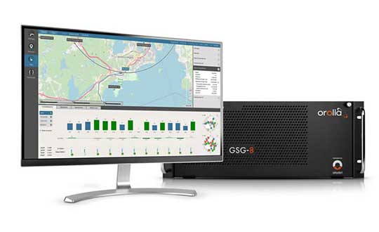
GSG-8, the latest advanced simulator from Orolia, was also introduced to the global GNSS community this week at ION GNSS+. This software-defined simulation solution offers ultra-high performance and unmatched flexibility in an easy-to-use format. GSG-8 was developed to deliver the highest standard of GNSS signal testing and sensor simulation performance, in an upgradable and scalable platform.
“With its scientific precision and advanced simulation capabilities, GSG-8 is revolutionizing the GNSS simulation industry with Orolia’s robust 1000Hz Skydel software engine and COTS software-defined radios,” said Stephane Hamel, director of testing and simulation at Orolia. “GSG-8 is designed for customers that require complex capabilities to validate product and program performance in harsh, high risk environments where failure is not an option- such as government agencies, space programs and specialized commercial programs.”
It can be programmed to simulate operations with multiple GNSS constellations and to incorporate the use of encrypted or proprietary signals. GSG-8 can also be configured for Wavefront and Anechoic chamber simulation protocols to test anti-jam antennas and complete systems, to serve the most challenging program requirements.