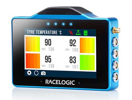
The VBOX Touch from Racelogic is the first in a new generation of highly flexible, enhanced accuracy GNSS dataloggers. The powerful hardware can be used in many types of diverse automotive tests such as acceleration, braking, speed verification, tyre temperature monitoring, lap-timing and durability, according to the company.
The VBOX Touch comes preloaded with a sophisticated performance application that covers many common use cases. Other applications can be downloaded free of charge from the Racelogic online library. Racelogic can also write custom scripts based on customer requirements.
The VBOX Touch has a daylight readable colour touchscreen, 10-Hz GNSS engine, Wi-Fi, Bluetooth, twin CAN ports, serial port, digital input and four multi-color LEDs.
Applications are written in Python script, offering greater flexibility as well as the potential for users to write code to solve their specific testing requirements. If you need a configurable, touchscreen display which can interact with two different CAN buses, log data, know the precise position and speed whilst giving clear feedback to drivers, then the VBOX Touch is for you.
A high-accuracy 2-cm RTK GPS version is available, which uses the latest dual-frequency GPS, GLONASS and Galileo signals to deliver accuracy even under difficult conditions. These new signals significantly increase the RTK resilience near trees and tall buildings, providing precise lap-timing, position triggers and trajectory maps in places where 2-cm GPS has typically not been available.
Founded in 1992, RACELOGIC are based in Buckingham, UK, and have supplied the Automotive industry with reliable and accurate GPS dataloggers for the last 18 years. In the development of the VBOX Touch we have worked closely with our end users to create a powerful tool to help them deliver results faster and more accurately on the test track or open road.
Flirtey, a pioneer of the commercial drone delivery, has unveiled the Flirtey Eagle, along with a video of the next-generation delivery drone performing consumer and automated external defibrillator (AED) deliveries to homes.
Flirtey’s system is designed to safely get packages to customers with the delivery goal of less than 10 minutes using drones.
Along with the Flirtey Eagle, the aircraft designer and manufacturer unveiled the Flirtey Portal, a sophisticated takeoff and landing platform that enables scalable store-to-door operations. Also part of the system is an autonomous software platform that enables drones to deliver safely to American homes.
Flirtey said it is on course to conduct drone deliveries to U.S. homes as early as 2019.
Here are highlights of the UAV’s technology.
Flirtey’s aircraft is designed to operate in 95% of wind and weather conditions, making it highly reliable for flight.
The Flirtey Eagle is designed to fit 75% of packages that get delivered to its customers’ homes during last-mile deliveries.
The Flirtey Eagle safely and precisely delivers its contents by lowering a tether, while the drone is suspended in air, and once the package is delivered, it then retracts the tether.
Flirtey’s aircraft is controlled by its autonomous software platform, which has received Federal Aviation Administration (FAA) approval for the first multi-drone delivery operation in the United States, enabling a single remote pilot to simultaneously oversee ten Flirtey drones.
Flirtey’s Portal is a sophisticated takeoff and landing platform that fits into one parking space, making its infrastructure easily scalable to the company’s partners for store-to-door delivery.
Flirtey’s drone delivery technology has been developed from the ground up, originating from NASA’s drone program. Flirtey Founder and CEO Matthew Sweeny has brought together a team of aviation industry veterans from NASA, Raytheon, Lockheed Martin, and SpaceX, as well as military veterans from the army, navy, and air force.
“We expect Flirtey’s advanced drone delivery system will become the industry standard in America,” said Matthew Sweeny, Flirtey founder and CEO. “Flirtey’s latest technology makes life-saving and commercial drone delivery to homes in the United States an imminent reality.”
The Flirtey Eagle builds upon the advanced technologies developed for Flirtey’s previous generation aircraft that conducted the first Federal Aviation Administration (FAA)-approved drone delivery in the United States, which is going on display alongside the Wright Flyer in the Smithsonian National Air and Space Museum in Washington, D.C. Flirtey’s goal is to not only meet, but to surpass the rigorous safety standards of the FAA. Flirtey’s regulatory approvals include:
Approval to conduct multi-drone delivery operations, enabling a single remote pilot to simultaneously oversee 10 Flirtey drones
Approval to conduct drone delivery flights beyond visual line of sight (BVLOS), enabling Flirtey to conduct drone delivery operations with a pilot controlling the flights from a remote location
Approval to conduct drone delivery flights at night, making drone delivery accessible at any time
Flirtey and the City of Reno were chosen for the FAA and Department of Transportation’s Unmanned Aircraft System (UAS) Integration Pilot Program (IPP). Within the IPP, Flirtey and the City of Reno have partnered with REMSA, local emergency medical services provider, to deliver AEDs to those in need. Flirtey’s AED delivery technology has the potential to save 150,000 lives per year, the company said.
Based on demand from customers, Flirtey expects demand initially to outstrip supply. Flirtey’s drone delivery system was designed from the outset to meet the anticipated high demand.
Updated GSS9000 Series takes a bow, joining range of test solutions on show
The Enhanced GSS9000 Series GNSS constellation simulator. (Photo: Tyler Gunter)
Spirent Communications will unveil its enhanced GSS9000 Series GNSS constellation simulator at ION GNSS+ 2019 in Miami, which will take place Sept. 16–20. It joins Spirent’s already impressive range of test solutions on display at the world’s largest showcase of GNSS technology, products and services.
“The industry is at a very important point,” said Spirent Marketing Director Steve Hickling. “With the volume of GNSS signals growing, more multi-constellation receivers being developed every day, and the need for greater precision increasing all the time, it’s vital that testing solutions are able to stay ahead of this reality. This is why we’re excited to demonstrate the enhanced GSS9000 Series at ION.”
The GSS9000 Series constellation simulator has been improved with enriched features and enhanced capabilities combined with an increased channel capacity. Most importantly, this greater flexibility, coherence, fidelity, performance, accuracy and reliability is maintained under all test conditions.
At ION, Spirent (booth E) will also be showing its GSS6450 — the highly portable 16-bit RF record and playback system — and the GSS7000 series multi-frequency, multi-GNSS RF simulation solution. Visitors can also learn more about Spirent’s realistic multipath and obscuration simulation tool, the new Sim3D.
Spirent’s expertise will also be demonstrated during three ION GNSS+ speaking panels:
“Seen & Heard” is a monthly feature of GPS World magazine, traveling the world to capture interesting and unusual news stories involving the GNSS/PNT industry.
Batman only wishes he had one
New miniature GPS “backpacks” are making it possible to track tiny desert bats, providing insight into their lives. Tiny 1-g GPS tags showed University of Helsinki researchers that Africa’s yellow-winged bats struggle during dry periods. The species is one of the few desert bats large enough to carry the tag. Researchers placed GPS trackers on 29 bats, 15 in the rainy season and 14 in the dry season, for one week each, and recorded their positions every 30 to 60 minutes each night.
Photo: iStock/ MBPROJEKT_Maciej_Bledowski
The wheels on the bus need GPS
All New York City public school buses will provide GPS tracking by the first day of class this fall. The city has teamed up with Via to install the equipment and provide an app for real-time tracking of the nearly 10,000 buses. The city council approved the tracking program after a sudden snowstorm in November 2018 left buses stranded in traffic for hours, and parents couldn’t reach their kids.
Keep on truckin’
Shipping company UPS is investing in autonomous deliveries, specifically in TuSimple, a robot-trucking startup. UPS is testing self-driving tractor trailers on a route between Phoenix and Tucson, Arizona, to help it understand requirements for Level 4 autonomous trucking. TuSimple completed a two-week pilot with the U.S. Postal Service in May, hauling mail between Phoenix and Dallas. All TuSimple trucks operate with two technicians in the cab, with the aim to operate without drivers within two years.
A+ for GPS Cows
High-school students interested in agricultural professions can now learn about the use of GPS for monitoring livestock, and even make their own GPS collars. The collaborative GPS Cows program brings together industry researchers, professionals and educators from the U.S. and Australia. GPS Cows is fighting the misperception that ag-focused students don’t need digital literacy, and is engaging them in agri-tech, specifically tools and systems that provide animal location and behavior data.
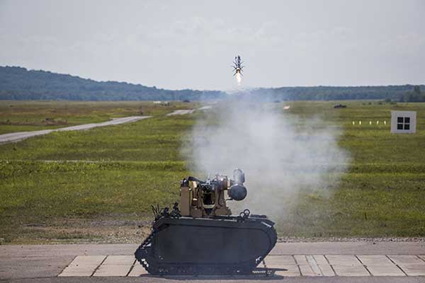
Remotely controlled Javelin firings can help keep soldiers out of harm’s way. (Photo: Lockheed Martin)
The Javelin Joint Venture team, a partnership of Raytheon Company and Lockheed Martin, successfully fired Javelin missiles from a Kongsberg remote launcher mounted on a Titan unmanned ground vehicle built by QinetiQ North America and Milrem Robotics.
The demonstrations, conducted at the U.S. Army Redstone Test Center, Alabama, validated the integration of the weapon station, missile and vehicle.
“Javelin is ready to support emerging military robotic vehicle requirements,” said Sam Deneke, Raytheon Land Warfare Systems vice president. “Remotely operated technology like this protects soldiers in battle.”
Javelin has been fielded on the Common Remote Operations Weapon Station-Javelin across U.S. Army Stryker 8×8 vehicle brigades in Europe.
“Javelin offers true fire-and-forget engagements to 4 kilometers in most operational conditions,” said David Pantano, Javelin Joint Venture vice president and Lockheed Martin Javelin program director. “Once the launch command is issued, soldiers and vehicle assets like the UGV can reposition out of harm’s way. These tests demonstrated our ability to evolve Javelin capabilities to address new missions in support of the warfighter.”
Javelin is a versatile one-man-portable and platform-employed anti-tank and multi-target precision weapon system. The Javelin Joint Venture team has produced more than 45,000 Javelin missiles and 12,000 command launch units. The program continually updates the system to stay ahead of advancing threats, including enhancing its platform-mounted capabilities.
U.S. and coalition forces have used Javelin extensively in Afghanistan and Iraq in more than 5,000 engagements.
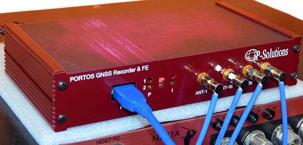
Portos Team paired with the Ninja. (Photo: iP-Solutions)
Japan-based iP-Solutions has introduced Portos Team, a new GNSS RF signal record-and-playback system.
The Portos Team can record and play back — or simulate —multi-frequency, multi-system GNSS signals when paired with the company’s Replicator. It can do the same for CRPA signals when paired with the Ninja (see photo).
The Portos itself can also operate as multi-frequency or CRPA front-end for a GNSS software receiver.
The high-end Ninja simulator allows for multi-antenna controlled radiation pattern antenna (CRPA) and local-area augmentation system (LAAS) simulation, the company said.
The 24-channel Replicator — developed in collaboration with the Japan Aerospace Exploration Agency (JAXA) — provides real-time generation of GNSS signals, recording and playback of dual-frequency GNSS RF signals, and GNSS RF signal analysis with JAXA COSMODE ionospheric scintillation monitor.
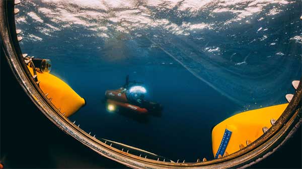
A sonar survey, camera and sensor data of the world’s largest marine sinkhole is shining light on sea level and climate change over 100,000 years.
From Nov. 27 to Dec. 13, 2018, the Blue Hole Belize Expedition mapped the sinkhole. Led by Aquatica Submarines, the team of scientists, explorers and film makers included Virgin ’s Sir Richard Branson and Fabien Cousteau, grandson of the conservationist Jacques Cousteau.
Kongsberg used both surface and submarine-mounted sonar equipment.
Sonar expert Mark Atherton from Kongsberg’s Canadian subsidiary Kongsberg Mesotech was a key member of the science-based sonar and scientific data collection team. Atherton operated the sonars aboard the Research Vessel Brooks McCall, contributing to an invaluable high-resolution map of the entire sinkhole.
“By understanding the geological history and geometric structure at the Blue Hole we can contribute new data to the global scientific community studying sinkholes and cenotes,” he said.
Photo: Aquatica Submarines
Aquatica Submarine’s Stingray 500 submarine was used for sonar surveying, filming and dives. The team conducted more than 20 dives into the large sinkhole, taking videos and 3D images during each trip. They also completed a two-hour live broadcast featured on The Discovery Channel.
A key outcome of the Expedition is creation of a complete 3D sonar map of the Blue Hole. The sonar map is enhanced with other passive submarine-collected environmental data. Once processed and collated, the data will be shared with the Government of Belize and the larger global scientific community as a legacy from the expedition.
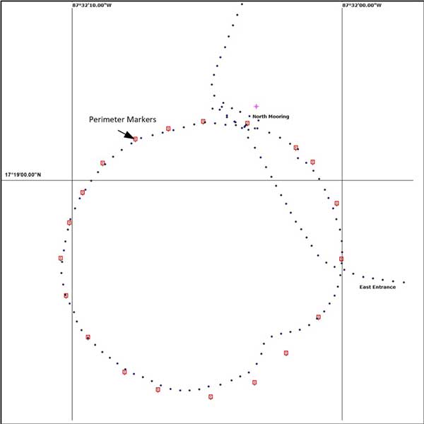
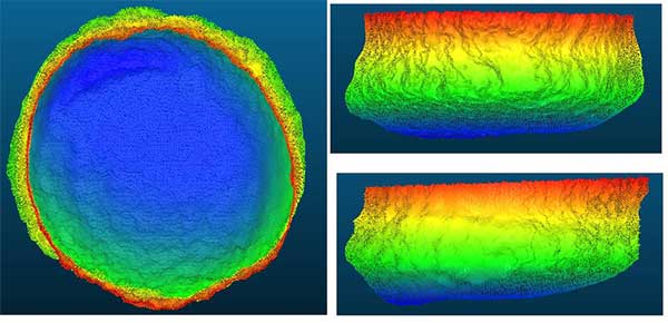
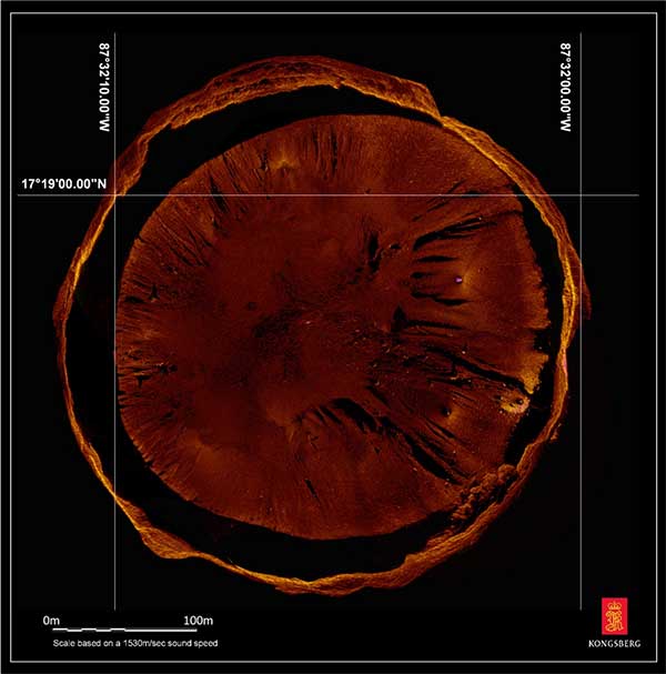
Perimeter Markers: Using an SBG Systems Ellipse receiver positioned directly over suspended tripods, positions were locked in the MS1000 processing software the instant each tripod touched bottom. With no current within the Blue Hole and the tripod and sonar weighing 21.7 kg, there was no issue with offset position differences between the vessel and the tripod hanging plumb during deployment. (Image: Mark Atherton/Kongsburg)Processed Scan Data: A dual-axis sonar (DAS) system collected point-cloud data to create a 3D representation of the Blue Hole. The unit was pole-mounted on the survey vessel with the GPS and motion reference unit directly over the scanner’s head. (Image: Mark Atherton/Kongsburg)Mosaic: GPS tripod position and target matching on overlapping scans were used to align the 50-, 75- and 100-meter-range data collected at 21 drop locations. This mosaic is a very close approximation of the bottom of the Blue Hole. (Image: Mark Atherton/Kongsburg)
GSA Executive Director Carlo des Dorides kicks off the celebration. (Photo: GSA)
News from the European GNSS Agency
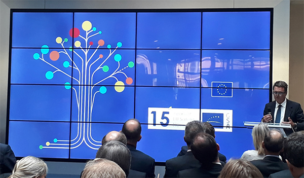
The European GNSS Agency (GSA) hosted a special event on Sept. 10 to mark the 15th anniversary of its creation. The agency was set up as the European GNSS Supervisory Authority in 2004 to oversee the development of the European space programmes EGNOS and Galileo.
GSA Executive Director Carlo des Dorides welcomed special guests to the GSA’s Prague headquarters to celebrate the event, including European Commissioner Elżbieta Bieńkowska, Czech Transport Minister Vladimir Kremlik, French Space Agency (CNES) President and GSA Administrative Board Chair Jean-Yves Le Gall and European Space Agency Director General Jan Woerner, in addition to other EGNOS and Galileo stakeholders.
“Over the last 15 years, the GSA has become one of the key players in building Europe’s independent capacity in satellite navigation,” said Commissioner Bieńkowska, responsible for Internal Market, Industry, Entrepreneurship and SMEs. While participating in the celebrations, the commissioner also presided over another historic milestone for both the Galileo programme and the GSA — the countdown to the 1 billionth Galileo-enabled smartphone sold.
“GSA has been at the heart of the EGNOS and Galileo programmes over the past 15 years.” — Carlo des Dorides.
Linking space to user needs
GSA Executive Director Carlo des Dorides said: “It is an honour and a great pleasure to celebrate this important milestone with representatives from all our stakeholders — the Commission, users, industry and other institutional bodies. Their presence here clearly shows that the GSA is delivering on its mission – linking space to user needs”.
“15 years ago, no one imagined how far the GSA and the EU satellite navigation systems EGNOS and Galileo would go. Now, no one can imagine Europe without Galileo and EGNOS, or Galileo and EGNOS without Europe. The GSA has been at the heart of these two programmes, accelerating progress in service provision, market uptake and guaranteeing operation security over the past 15 years. All that has been accomplished has been made possible thanks to the unique blend of expertise, dedication and commitment of the GSA’s staff,” des Dorides said.
Speaking at the event, GSA Administrative Board Chair Jean-Yves Le Gall said: “Today thanks to the European Union’s impressive investment, the European Space Agency’s technical expertise and the GSA’s outstanding commitment, Galileo is offering the best localization available worldwide. The range of applications is vast. This is structuring our economy and the implementation of the public policies to ensure that European companies are taking full advantage of these fantastic services.”
Czech Transport Minister Vladimir Kremlik noted the importance to the Czech capital of hosting the EU agency. “It has been fifteen years of hard work and continual development. By chance it is also seven years since the seat of GSA has been relocated from Brussels to Prague. I am very proud, that the Czech Republic is the hosting country of the seat of such an important European agency with real global reach,” the minister said.
Looking to the future
Galileo will soon reach its Full Operational Capability, a phase that will require new governance to comply with benchmarked standards for the management of operational satellite services. It was with this in mind that the European Parliament and the Council agreed on a new EU Space Programme Regulation establishing the EU Agency for the Space Programme (EUSPA) as the successor to the GSA.
“In the new governance the Commission will continue to be responsible for managing the overall programme. The GSA, to be renamed the ‘EU Agency for the Space Programme,’ will increasingly support the exploitation and market uptake of EU space activities and play an increased role in ensuring the security of all programme components. The intergovernmental European Space Agency (ESA), given its expertise, will remain a major partner in the technical implementation of the EU space programme,” des Dorides said.
As George Bernard Shaw said, “Progress is impossible without change.” Our industry is a great example of that. We have grown from a single GPS service to multiple GNSS constellations, to today’s increasing integration of GNSS solutions with other positioning, navigation and timing (PNT) technologies.
Since its founding 30 years ago, GPS World also has been constantly adapting and advancing so we can better report on, and help shape, our brilliant GNSS/PNT industry.
GPS World now includes expanded coverage of PNT solutions and related integration trends. We also dive deeper into GNSS/PNT developments through Q&As with leading industry suppliers, and we deliver more leading-edge application stories in high demand by our readers.
Other recent changes at GPS World revolve around our editorial staff. This month, we say goodbye to Alan Cameron, our editor-at-large, who served our media brand for 19 years. We wish Alan well.
“Our commitment to delivering timely, accurate, insightful GNSS/PNT intel has never wavered.”
Matteo and Sofranec. (Photos: GPS World)
Please join us in welcoming Diane Sofranec as GPS World’s staff editor. Diane brings with her more than 30 years of experience writing and editing content for business-to-business magazines and digital media. GPS World also is excited to welcome Matteo Luccio as a regular contributing editor.
Luccio possesses almost 20 years of experience as a writer and editor for GNSS and geospatial technology media. Luccio began his career in the industry in 2000, serving as managing editor of GPS World and Galileo’s World, then as editor of Earth Observation Magazine and GIS Monitor. Luccio earned a master’s degree from the Massachusetts Institute of Technology.
In 2020, Luccio will pen GPS World cover stories detailing trends and new solutions in receivers, antennas, simulators and PNT technologies, as well as monthly secondary features on wide-ranging topics.
During the evolution of GPS World over the past 30 years, one thing has remained constant: Our commitment to delivering timely, accurate, insightful GNSS/PNT intel has never wavered. Our stable of staff editors and regular contributors collectively possesses 200 years of GNSS/PNT experience, and our audited audience reach tops 237,000 across all media platforms.
We’re excited to continue to serve you, our family of loyal readers and marketing partners, for decades to come. Together, we remain committed to advancing our knowledge, organizations, profession and world.
Mothers Against Drunk Driving (MADD) has partnered with Velodyne Lidar, a provider of real-time 3D perception systems for a range of commercial applications, including autonomous vehicles. The initiative includes a website on the safety benefits of autonomous vehicle technology (see velodynelidar.com/madd-partnership.html) and an October conference on autonomous safety.
“We have learned that technology is essential to getting us to our goal of zero deaths caused by drunk driving,” said MADD President Helen Witty. “Autonomous vehicle technology holds the incredible promise of helping us eliminate drunk driving.”
The summit is designed to advance understanding of the safety benefits that can be achieved with autonomous vehicle technology. It is designed for business, government, public safety and community leaders. Attendees will have the opportunity to ride in autonomous vehicles.
Marta Hall, Velodyne Lidar’s president and chief business development officer, added, “Our goal is to design, develop and mass-produce lower cost lidar sold for every model of car and truck.”
The two organizations partnered in 2018 to create the website with information on how autonomous vehicles can help prevent roadway collisions. The site explains the basics of autonomous driving in easy-to-understand language for all audiences. Content modules include “Lidar 101,” explaining how lidar sensor technology is an essential component of self-driving vehicles.
A 3D lidar sensor such as the Velodyne Alpha Puck can deliver information to help enable vehicle autonomy and advanced driver-assistance systems. (Image: Velodyne)
“The promise of safe, self-driving cars is very exciting, particularly for those of us who have seen the devastation that impaired driving and human error can bring,” said former MADD President Colleen Sheehey-Church.
Puck Sensor. The Velodyne Alpha Puck is a lidar sensor specifically made for autonomous driving and advanced vehicle safety at highway speeds. In a session at July’s Automated Vehicle Symposium, company speakers presented “High-Definition 3D Lidars: An Integral Part of Future Autonomous Driving,” including use cases that have proven elusive for solutions based on camera and radar; and “State of Solid-State 3D Lidar,” a technical presentation on application-specific integrated circuits (ASICs).
“Core lidar electronics are moving from a printed circuit board to an ASIC, which provides advantages such as higher density, lower cost and improved reliability,” said UAV and Robotics Business Manager Frank Bertini. “The trend roughly follows Moore’s Law, leading to dramatic decreases in size, weight and cost over relatively short time periods.”
Septentrio has introduced a GNSS/INS receiver designed specifically for unmanned aerial vehicles (UAVs). The AsteRx-i S UAS combines GNSS technology with industrial-grade inertial sensor to provide high-accuracy, reliable positioning and 3D orientation (heading, roll, pitch) to aerial drones and other compact robotic systems.
Septentrio’s introduction of AsteRx-i S UAS builds on top of the success of the company’s existing UAV products, AsteRx m2 and m2a UAS. Its optimized SWaP (size, weight and power) increases UAV battery life resulting in longer flight times and improved productivity.
Intergeo, Hall 1, Booth D1.040, Sept. 17-19, Stuttgart, Germany
Photo: Allison Barwacz
This credit-card-sized receiver is designed for easy integration into any UAS (unmanned aerial system) and is compatible with popular autopilots such as Pixhawk and ArduPilot. It is a single-package GNSS/INS product, with an on-board IMU (inertial measurement unit) and standard connectors, allowing flexibility of sensor choice.
“Quick receiver integration makes the lives of our customers easier. It also speeds up their system’s time-to-market,” said Danilo Sabbatini, Product Manager at Septentrio. “Our goal was to combine a high-performance product with a simple and flexible plug-and-play integration design, suitable for any aerial system.”
Septentrio reliable centimeter-level positioning is based on multi-frequency, multi-constellation GNSS technology (GPS, GLONASS, Galileo, BeiDou, QZSS). AsteRx-i S UAS combines a GNSS receiver with a high-quality IMU to deliver reliable positioning together with 3D orientation.
Septentrio’s unique GNSS — IMU integration algorithm provides continuous positioning during short GNSS outages (coasting) which can happen in flight near high structures, under bridges or during banking turns.
AsteRx-i S UAS comes with built-in industry leading Advanced Interference Mitigation (AIM+) technology. In aerial drones, where lots of electronics are crammed into a small space, neighboring devices can emit electromagnetic radiation which interferes with GPS and GNSS signals.
AIM+ offers protection against such interference resulting in faster set-up times and robust continuous operation. A built-in power spectrum plot allows users to analyze interference, helping locate its source and mitigating it.
GMV has been awarded a contract for development of a precise GNSS positioning system with integrity for the new generation of autonomous vehicles of the German carmaker BMW Group.
The Spanish multi-national’s technology solution is going to be developed for the first time in BMW Group’s autonomous vehicles. GMV’s positioning software calculates the vehicle’s position and other magnitudes, using advanced GMV-developed algorithms, including components that have already been patented. These algorithms have been especially modified and adapted to meet BMW Group’s performance and safety requirements.
Photo: BMW Group
The developed software will abide by the most demanding automotive standards and the highest quality levels of safety-critical software, GMV said.
Another key component provided by GMV is a GNSS correction service to be run in a secure infrastructure using data from a global network of monitoring stations to be set up by GMV under this contract.
This new project cements GMV’s position as a supplier of GNSS-based autonomous-car positioning solutions, the company said.
“GMV has been investing for many years in the key GNSS technologies that are essential for autonomous driving systems,” said Miguel Ángel Martínez Olagüe, GMV’s general manager of Intelligent Transportation Systems. “For our company this contract represents a unique opportunity to capitalize on all that effort, providing a product of outstanding performance for the automotive industry.”