Skyfront’s Perimeter 4 long-range hybrid gas-electric drone this summer successfully performed the first civilian beyond-visual-line-of-sight (BVLOS) flight without visual observers under the FAA’s Part 107 rules.
The flight serves as a significant step toward the safe integration of unmanned aerial vehicles into the national airspace, according to the company.
During the round-trip flight, the Perimeter UAV flew over mountainous, rugged terrain along a four-mile stretch of the Trans-Alaska pipeline. The UAV maintained a constant above-ground altitude of 400 feet with multiple ascents and descents of 1,000 feet on 45-degree slopes. Radio-based telemetry, command and control of the vehicle was uninterrupted during the flight.
FAA representatives observed all aspects of the mission, including planning, system setup and ground-station operation. The Perimeter “did [the flight] safely, effectively and efficiently. It accomplished a beyond-visual-line-of-sight mission, and it was approved by the FAA,” said Robert Huber, program manager for the Integration Pilot Program (IPP) of the FAA.
“Today’s flight was a milestone in the unmanned community,” said Troy Mestler, CEO of Skyfront. “We at Skyfront are excited to be pushing the limits of unmanned aerial vehicles here in the United States.”
The Perimeter UAV was integrated with Iris Automation’s Casia collision avoidance system and was observed by Echodyne’s ground-based detect and avoid systems.
The University of Alaska Fairbanks and the Alaska Center for Unmanned Aircraft Systems Integration purchased the UAV and organized the flight over the pipeline, with the approval of the Alyeska Pipeline Service Company.
The U.S. Department of Transportation is preparing for a GPS backup and complementary positioning, navigation and timing demonstration for the Department of Defense at the Joint Base Cape Cod, Massachusetts.
Demonstration for testing is expected to begin in the spring of 2020, and DOT is seeking contractors to make Building #2410 at the base functional so that the demonstrations can be held there.
Diana Furchtgott-Roth, deputy assistant secretary of Transportation for Research and Technology, is leading the project. Working through the Volpe National Transportation Systems Center, Furchtgott-Roth’s goal is to demonstrate as many of the technologies as possible and conclude the effort by March of next year.
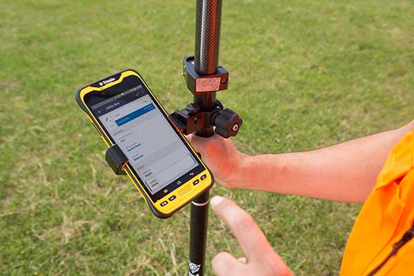
Spectra Geospatial has introduced the MobileMapper 60, a durable, efficient and accurate handheld device for geographic information system (GIS) and professional data-collection applications.
The MobileMapper 60 all-in-one GNSS receiver and smartphone combines a convenient form factor for geospatial data collection with 2-4 meter positioning accuracy. Its slim, lightweight all-weather design, complete with a hand strap, features a large 6-inch screen with high resolution for easy viewing and data manipulation.
With a large capacity all-day battery and rugged exterior, the MobileMapper 60 will operate continuously in range of extreme temperature and environmental field conditions.
Running an Android 8.0 operating system, it has a fast 2.2 GHz processor, 4 GB of memory and 64 GB of storage for managing large data sets with ease and speed. Bluetooth 4.1, 4G LTE and Wi-Fi capable, the MobileMapper 60 is ideal for a wide range of jobs, including cadastral, survey, topographic, forestry, control and much more.
“The MobileMapper 60 gives GIS and survey professionals a rugged, easy-to-use, smartphone device for data collection in the field,” said Olivier Casabianca, general manager, Spectra Geospatial. ”The MobileMapper 60 is a powerful solution for field professionals , making it easier than ever to work efficiently in the field.”
TerraFlex users can now synchronize data directly to their on-premise Esri geographic information system without cloud services.
Photo: Trimble
The new software workflow — called offline data transfer — is possible through the integration of Trimble TerraFlex and the Trimble Positions Desktop add-in for Esri ArcGIS Desktop.
TerraFlex is a field solution that enables mobile workers to easily collect, manage and edit their geospatial feature data.
The new workflow provides an alternative to using Trimble cloud services for storing and transferring GIS feature data collected with the TerraFlex platform. In addition, TerraFlex field data collected via this workflow using a Trimble GNSS receiver can be post-processed directly inside the Trimble Positions Desktop add-in for improved positional accuracy.
“With this new feature, TerraFlex fulfills the need of organizations such as government agencies and utility providers who cannot keep their data in the cloud because of regulatory constraints or business rules,” said Rachel Blair-Winker, business area manager for Trimble Mapping & GIS solutions.
“By introducing the new workflow to our TerraFlex software platform, customers who prefer direct desktop methods of transferring data between field and office (such as USB) and need post-processing capabilities can now benefit using this new solution without having to change their current business practices,” Blair-Winker said.
Trimble TerraFlex is available online or through Trimble’s Authorized Geospatial distribution channel. The mobile apps are available in Apple’s App Store and the Google Play store.
The Trimble Positions Desktop add-in is available through the Trimble Geospatial distribution channel. The new workflow functionality will require the latest version of both applications.
The last two U.S. presidential administrations failed to follow through on promises to protect GPS and the nation with a system to backup GPS. A recent Department of Transportation (DOT) appointee is aiming to fix that.
Diana Furchtgott-Roth is deputy assistant secretary of Transportation for Research and Technology. Her office has a broad range of responsibilities including as the federal government lead for civil GPS and PNT issues.
Since Furchtgott-Roth arrived at the department in February, she has been adamant about the need to establish a complementary and backup system that users can access when GPS is not available or signals need reinforcing. She notes that this has been a presidential policy requirement for DOT since 2004.
There are also two Congressional mandates on this issue. The first mandate was in a law passed in 2017. The National Defense Authorization Act tasked the Departments of Defense, Transportation, and Homeland Security to jointly conduct a technology demonstration of GPS backup technology.
Congress funded this project in 2018 through the Defense department, even though DOT was the lead agency. Bureaucratic delays in transferring the funds between departments has meant that, rather than concluding in the summer of 2019 as initially required, the demo is behind schedule by about eight months.
Much of this transpired before Furchtgott-Roth arrived on scene and she is determined to make up for lost time.
A Request for Information (RFI) seeking candidate GPS backup technologies was issued in early May of this year and closed 30 days later. Twenty-two responses were received, though some just offered comments and observations rather than proposing technologies.
Working through the Volpe National Transportation Systems Center, Furchtgott-Roth’s goal is to demonstrate as many of the technologies as possible and conclude the effort by March of next year.
“We want to thoroughly understand all of the proposed technologies, including their ability to penetrate indoors and underground without assistance,” Furchtgott-Roth said.
The department’s procurement website forecasts a Request for Proposals for this effort this month (the site says it will be issued in the fourth quarter of the fiscal year which ends on Sept. 30). The opportunity is described as “Backup Global Positioning System (GPS) Technical Consulting Services for participation in a technology demonstration” with an estimated value of between $700,000 and $2,000,000.
Small businesses that want to be on the notification list for this can do so through the FedBizOpps announcement page.
The second legislative mandate was signed into law in December 2018. The National Timing Resilience and Security Act requires the Department of Transportation to establish a timing system to back up GPS by December 2020.
Among the requirements specified in the Act are that the system must be terrestrial, wireless, have wide area coverage, be difficult to disrupt, and be capable of expansion to provide positioning and navigation services.
Furchtgott-Roth plans to integrate the department’s responses to both taskings as much as possible. “What we learn from the tech demo should very much inform the implementation of the National Timing Resilience and Security Act,” she said.
She also wants everyone on the project to keep in mind that establishment of the timing system is just the first phase of creating a more robust and resilient national PNT architecture. “Timing is important, and we are going to reinforce it first,” she said. “But it is not going to provide resilient positioning and navigation for drones, autonomous vehicles, and all our other transportation needs. America must have a combination of systems available that, when used together, will be very difficult to disrupt.”
To keep things moving quickly, Furchtgott-Roth says she is leaning toward signals provided by a commercial entity, rather than a government-built system.
“The Act suggests we consider a public-private-partnership, and there are a lot of advantages to that,” she said. “The government wouldn’t need to stand up a big acquisition staff or have a large appropriation of funds from Congress. Also, private entities are often able to act faster and be more agile. And they assume most of the project risk.” The aviation safety ADS-B system was created using such a procurement model.
The only snag is that while Congress has appropriated money for the tech demo, it has not yet done so for the mandated operational system. Sources in Congress point out that although the House version of the 2020 budget has $32 million for Air Force “Resilient PNT,” nothing has been allocated for civilian users.
“$32 million would go a long way for DOT’s efforts to protect the 99.9% of GPS users who are not in DoD,” said one congressional staff member. He was hopeful the Senate would designate funds in its version of appropriations for DOT and the issue would be resolved positively in conference.
“GPS has become an invisible utility that so many of our technologies depend upon,” observed Karen Van Dyke, who leads PNT efforts for Furchtgott-Roth’s office. “Providing a complementary and/or backup capability ensures users have PNT even when GPS is disrupted. It may also help protect the signals themselves by deterring malicious actors who might otherwise want to jam or spoof GPS.”
“President Trump’s top priorities are national and economic security. We can’t have GPS signals be a single point of failure for transportation and other critical infrastructure sectors,” Furchtgott-Roth said.
Dana A. Goward is the president of the Resilient Navigation and Timing Foundation.
Providing significantly improved capability, flexibility and performance, the GSS9000 Series has been updated to meet the ever more demanding test needs of high-performance satellite navigation systems.
Spirent already leads the market in multi-frequency, multi-GNSS RF constellation simulators, and the enhanced GSS9000 Series’ enriched features and capabilities raise the bar for GNSS development and test still further.
Photo: Spirent
“We’re seeing the number of GNSS signals growing all the time, and an ever-increasing number of the receivers and systems we rely on every day are making use of these signals to improve accuracy, availability and continuity,” said Spirent Managing Director of Positioning, Martin Foulger. “That’s why it’s important that GNSS testing today and going forward reflects the reality of real-world situations, where simultaneous generation and testing of all signals is vital.”
The enhanced GSS9000 Series addresses this need by doubling the number of supported channels (320 in a single chassis) while maintaining its full performance specification, including in key areas such as signal iteration rate and low latency, under maximum signal dynamics.
These attributes, together with the ability to produce a comprehensive range of emulated multi-GNSS, multi-frequency RF signals, enables full and future-proofed testing of advanced applications.
“Because the GSS9000’s dedicated platform and software are designed from the ground up to work together, there is no need for a trade-off between capacity and performance,” says Foulger. “The newly-enhanced platform provides full control and verification at maximum performance across all channels at all times, removing any need for our customers to compromise their testing regimes.”
Greater signal flexibility is also built into the enhanced GSS9000 Series, through its open API and flexible system architecture. This delivers a highly-sophisticated arbitrary waveform generator (AWG) capability.
It also provides unrivalled coverage and support for all current Signal-in-Space Interface Control Documents (SIS ICDs), with even greater flexibility for both system and signal evolutions.
This includes built-in and user-defined parameter controls for generation of non-current SIS ICD PRN codes, navigation data content, navigation data rate, chipping rate, edge shaping and modulation types.
The enhanced GSS9000 Series also features sophisticated spoofing test capabilities, with full parametric control of multi-copy constellations, and trajectory spoofing/meaconing. Precise phase-aligned signal wavefront generation and multi-antenna/output capability is supported, creating the most capable anti-jam and anti-spoof test system available anywhere.
“Spirent has an unmatched pedigree in GNSS test, stretching back more than 30 years. The enhanced GSS9000 Series is the next step in the continuous advances we’ve been making over that period,” Foulger said. “Once again, we have applied our unique expertise and experience to provide those working in high-end GNSS technology and application development with an advanced test solution that meets their current and future needs.”
The enhanced GSS9000 Series will be officially unveiled at ION GNSS+ 2019 in Miami, Florida (Sept. 16 – 20).
Ten projects in the MyGalileoApp competition have been named finalists.
Out of a shortlist of 30 semi-finalists, the 10 were judged to be the most exciting in terms of innovation, market potential and technical feasibility.
The 10 projects will now advance to the second development phase, at the end of which they should deliver a fully functioning app.
The STPR augmented reality app. (Screenshots: GSA)
Four of the 10 shortlisted projects are in the Augmented Reality and Games innovation area:
uMaze (Finland) — uMaze creates mazes in specific outdoor areas in which users can play.
ARGEO (Italy) — ARGEO allows users to discover content such as prizes, coupons and shopping cards geo-located around the streets of a city.
STPR (Poland, Australia, Ukraine) — The STPR app combines a virtual environment with game-related physical experiences in the real world.
arstory (Germany) — Arstory is a complete augmented reality ecosystem based on four main components: Galileo location, virtual objects in the real world, clustering of objects and a wide array of content options.
Apps in the smart navigation and infotainment innovation area include:
Ready Park (France) — Ready Park makes parking easier by pairing drivers leaving a spot with users looking for one.
Galileonaut (France) —Galileonaut helps sailors navigate inside a port or a marina and provides a link to the harbour master’s office.
Trukatu (Spain) — Trukatu is a mobile C2C platform that connects people who want to rent or lease items with owners who have items to rent.
Two of the shortlisted projects fall in the Fitness, Sport and mHealth category.
PanPan – Possible Assistance Needed (Germany) — PanPan serves as backup safety solution for potentially dangerous activities that may leave users in need of assistance.
LetMeAut (Italy) — LetMeAutmakes everyday tasks easier for people with autism.
One app is in the Mapping, GIS and Agriculture innovation area.
Tractor Navigator (France) — Tractor Navigator provides guidance for farmers driving tractors, enabling them to visualise their current position and trajectory in an open field.
The 10 projects have until Oct. 21 to deliver a finalized version of their app with 100% functionality. During this phase, the teams can receive technical support from the competition’s technical and business advisory team. At the end of the phase, the application should be already available for download on the Google Play and Apple platforms.
“The standard of entry in this year’s competition was very high, which made the judges’ task a difficult one. However, the final 10 projects stood out in terms of their innovative approach and uptake potential and we are looking forward to seeing the final working apps in October,” said Justyna Redelkiewicz Musial, in charge of LBS and IoT market development at the European GNSS Agency (GSA). “We hope that the 20 projects that didn’t make it into the second development phase will continue to develop their apps because, at the finals, they will also have the opportunity to demonstrate the progress that they have made,” she said.
All teams that will successfully complete the second development phase will be invited to the finals in November, where they will present their application to the GSA evaluation board.
The awards will be decided after these presentations, with the first-place winner receiving a EUR 100,000 prize. The runner up and third place winners will receive EUR 50,000 and EUR 30,000 respectively.
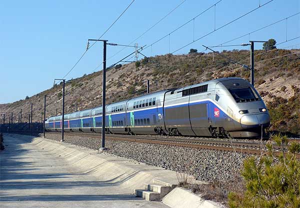
The French national rail company SNCF is adopting Galileo technology to boost customer services, in particular in its high-speed TGV network. TGV is France’s intercity high-speed rail service, and is operated by the SNCF.
With almost 50% of TGV trains already equipped with Galileo receivers, European GNSS is enabling improved customer information and traffic management.
Galileo is a technology building block that can precisely and safely locate trains and contribute to the future evolution of the European Rail Traffic Management System (ERTMS). ERTMS aims to harmonize signaling systems across Europe, and European GNSS can help reduce its costs.
SNCF is already embracing GNSS-based systems, in particular for passenger information, and fleet and traffic management.
“At the beginning of 2019, some 250 high-speed trains were already equipped with Galileo-ready receivers,” said Antoine Barre, head of SNCF train localization projects. “This represents nearly 50% of SNCF’s TGV fleet. Some 320 trains are expected to be Galileo-ready by the end of 2019.”
70 million passengers to benefit
The aim is to deliver Galileo-enabled services along the entire train journey and customer experience. During 2019, more than 70 million passengers will benefit from the improved accuracy and positioning availability delivered to French TGV trains by Galileo.
SNCF aims to equip its entire train fleet with Galileo receivers to assist non-safety relevant train localization. It also plans to further investigate the future contribution of European GNSS within ERTMS.
“Having Galileo on the iconic TGV trains is a major milestone for us, confirming that European GNSS is delivering a clear value added to one of the main EU Railway undertakings,” said Daniel Lopour, GSA market development officer.
“It is also good to see that SNCF is further progressing towards GNSS adoption on the regional fleet on the basis of the GSA position paper delivered earlier to the Community of European Railways (CER), explaining the benefits of Galileo for such applications,” Louper said.
Currently, signaling is enabled by equipment installed along rail tracks that requires regular inspection and maintenance. Accurate and reliable geolocation using GNSS will enable rail networks to reduce the cost related to the infrastructure.
Receivers installed in the train and connected via wireless networks should considerably reduce the costs of operation, maintenance and renewal of the network.
SNCF has identified three main themes of work for future rail technologies: geolocation, telecommunication and the use of satellite images for infrastructure monitoring.
Technology forward
Speaking at the Space for Innovation in Rail event, held in Vienna, Austria, March 18-19, Corinne Talotte described SNCF’s Technology Forward programme. Talotte is director of Innovative Technologies at SNCF. Talotte explain that the SNCF program is looking to build the “Railway for the Future” — a railway that is “autonomous, connected and zero emission.”
This spirit of innovation at SNCF aims to accelerate the implementation of new technologies. “First, this involves keeping an open mind on innovation and learning from other transport sectors,” Talotte said. “And our second important principle is to move to demonstrate innovative technologies as soon as possible in real operational situations to prepare the future deployment of innovations.”
Highly precise geolocation is a key element to enable autonomy in all modes of transport and future mobility systems. For trains, autonomous operation can increase the density of trains operating in the network while at the same time improving safety and reliability of customer services.
Space4Rail: From innovation to implementation
“We need to know accurately the position, velocity and attitude in real time to enable autonomous train systems,” explained Talotte. “We are developing a multi-sensor system for localisation based on GNSS but combined with other inertial sensors.
“This hybrid approach is inspired by the approach already adopted in the aviation sector. SNCF is undertaking a number of demonstrations with several partners, including the ERTMS user group and the Shift2Rail Joint Undertaking.”
Hybrid architecture
At the Space for Innovation in Rail event, Corinne Talotte said that SNCF was working on the remote operation of trains for use cases like shunting yards and the development of fully autonomous train prototypes.
The hybrid architecture makes it possible to take advantage of the benefits offered by both technologies: GNSS corrects the natural drift of the inertial unit, and when GNSS is not available, for example in tunnels or in dense urban environments, the inertial unit can take over to ensure continuity of location data. The inertial unit also protects the system from any possible disturbances in the GNSS signal, such as jamming or spoofing, as well as environmental factors.
The use of autonomous trains with innovative network control systems should enable SNCF to increase throughput on its lines. The objective is to carry more people and more goods, with greater regularity, improved energy efficiency and better economic performance, while ensuring continuing high levels of safety.
SNCF believes that the autonomous train is no longer science fiction, but the immediate future. A first prototype remote-controlled freight train should be tested some time this year, and the first prototypes of freight and passenger trains with autonomous driving capability are predicted beginning in 2023, with gradual implementation.
Latitude Geographics (a VertiGIS company) has released the 4.12 version of its flagship product Geocortex Essentials to make it easier for developers of mapping applications to take advantage of Esri’s ArcGIS technology.
Smart mapping. Using Esri’s smart-mapping functionality, GIS departments around the world are creating eye-catching, informative maps in ArcGIS Online. Smart mapping allows analysts to visualize and review their data in unique ways to discover trends and solve complex problems. By styling data and displaying it in a thematic map, hidden meaning can be found.
For example, a map can now be created that uses clustering, opacity and varying color schemes to display:
the most prevalent level of education in a county by neighborhood,
the incidence of that level of education in that neighborhood, and
the variance from that mean level of education in that neighborhood.
Web maps output from ArcGIS Online can now be imported into Geocortex Viewer for HTML5 (GVH) exactly as they are, meaning that all smart mapping symbology, legends and other information will be preserved and appear in GVH in the same format.
Scripting. The Arcade expression language adds powerful scripting capabilities to the ArcGIS platform. By writing simple scripts, users can manipulate their map data on the fly in several ways.
For example, a user could use an Arcade script to set up an identify parcel operation that also returns a summary of both the population density and communications infrastructure in the area, along with any other variables of interest. The portability of these scripts allows them to now be used within Geocortex applications.
“The new functionality added in this release provides even stronger support for developers using the ArcGIS platform, particularly those familiar with creating smart maps in ArcGIS Online,” said Drew Millen, chief technology officer for Geocortex. “It’s now easier than ever to build a mapping application that pulls data from various sources and uses it creatively to improve decision making.”
To learn more about the latest version of Geocortex Essentials, visit the company’s product release page.
UAvionix is offering free pingRX unmanned aircraft system (UAS) ADS-B receivers to first responders and UAS service organizations participating in rescue and recovery efforts associated with Hurricane Dorian.
Hurricane Dorian is expected to travel along the Eastern coast of the U.S. northward at a slow pace, creating extensive damage from winds and flooding.
UAvionix is a designer and manufacturer of communications, navigation and surveillance (CNS) equipment for unmanned and manned aircraft.
The pingRX. (Photo: uAvionix)
PingRX is a dual-frequency ADS-B receiver designed for use onboard a UAS. Retailing for $249 and weighing 5 grams, pingRX can provide the operator with a digital view of ADS-B-equipped aircraft in the airspace up to hundreds of miles away.
When integrated with a compatible autopilot — such as ARDUPILOT, Pixhawk, PX4 or the Cube — local ADS-B traffic is displayed on the ground control station (GCS) display.
Image: National Weather Service
The FAA’s mandate for ADS-B OUT equipage on manned aircraft has a deadline of Jan. 1, 2020, so equipage levels are currently high. Users are cautioned, however, that equipage is not at 100%, so reliance on ADS-B as a sole means of detect and avoid (DAA) is not advised.
In 2017, in response to Hurricane Harvey’s landfall in Houston, Texas, UAS were used extensively for the first time in recovery and rescue efforts. The use of UAS has continued to grow in response to hurricane efforts ever since.
Photos: NOAA
“Over the past few years, the use of drones in hurricane and natural disaster recovery efforts has increased significantly due to the value of the real-time data collected in combination with ease of deployment,” said Christian Ramsey, uAvionix president. “First responders and recovery crews will undoubtedly work tirelessly for weeks in response to Dorian. We hope to make these efforts just a bit safer and encourage good airspace safety practices with the use of the pingRX systems.”
The FAA has published guidance for UAS operators, urging strict adherence to Notices to Airmen (NOTAMS) and Temporary Flight Restrictions (TFR). The airspace in these areas can be crowded and unpredictable.
First responders and UAS service organizations are encouraged to contact uAvionix at [email protected] for details on the offer.
Grand Bahama Island before Hurricane Dorian. (Photo: Google)
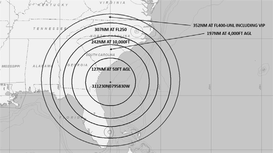
A U.S. Navy exercise in the southeastern United States will involve GPS interference testing that could make aircraft navigation unreliable or unavailable on Aug. 30 and Sept. 5.
The Federal Aviation Administration issued an advisory about the testing, which will be centered in the Atlantic off the coast of Savannah, Georgia, on the SAV VOR 139-degree radial at 84 nautical miles.
It could affect GPS reliability — including WAAS, GBAS and ADS-B — centered at 311230N 0795830W (SAV139084):
within a 352-nautical-mile radius at Flight Level 400
within 307 nautical miles at Flight Level 250
within 242 nautical miles at 10,000 feet
within 197 nautical miles at 4,000 feet above ground level
within a 127-nautical-mile radius at 50 feet above ground level.
The tests are scheduled for 1800 Zulu to 2200 Zulu on Aug. 30, and 1600 Zulu to 2000 Zulu on Sept. 5.
The FAA advisory states that GPS interference notices to airmen may change with little or no notice, and encourages pilots to check regularly for updates. NOTAMs will be published at least 24 hours in advance of any GPS tests.
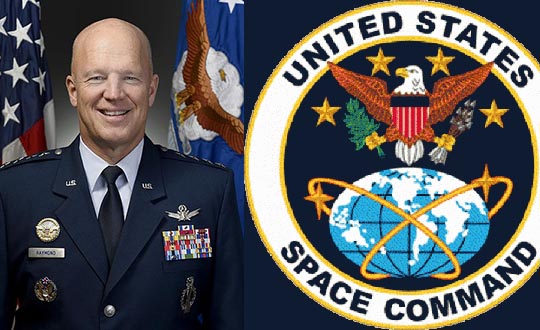
In a move to enhance the United States’ space superiority capabilities, the United States Space Command (USSPACECOM) was formally re-established.
USSPACECOM existed from 1985 to 2002 but was absorbed into U.S. Strategic Command in 2002 to make room for U.S. Northern Command and a greater focus on homeland defense.
From establishment to full operational capability, General Raymond will remain dual-hatted as the commander of Air Force Space Command and U.S. Space Command. The GPS constellation is operated by Air Force Space Command’s 50th Space Wing at Schriever Air Force Base east of Colorado Springs.
USSPACECOM will have a temporary headquarters of about 280 people at Peterson Air Force Base, Colorado.
“Establishing USSPACECOM is a critical step that underscores the importance of the space domain and its strategic contributions to U.S. national security,” the U.S. Space Command stated in a news release. “The USSPACECOM establishment will accelerate the United States’ space capabilities to address rapidly evolving threats to U.S. space assets and the importance of deterring potential adversaries from putting critical U.S. space systems at risk.”
“The scope, scale and complexity of today’s threat is real and it is concerning,” said Raymond during the establishment ceremony. “The establishment of a Combatant Command solely focused on the space domain demonstrates the United States’ commitment to protecting and defending its space assets against that threat.”
Emblem of USSPACECOM
The USSPACECOM mission is to deter aggression and conflict, defend U.S. and allied freedom of action, deliver space combat power for the Joint/Combined force, and develop joint warfighters to advance U.S. and allied interests in, from and through the space domain.
The command will be postured to protect and defend, while increasing joint warfighter lethality by executing two primary missions focused on
unifying and leading space capabilities for the Combined Force, and
maintaining U.S. and Allied advantages in space through protection and defense.
USSPACECOM’s global area of responsibility includes the area surrounding the earth at altitudes equal to or greater than 100 kilometers above mean sea level.