Author: Tracy Cozzens

  • Is internet time good enough for cybersecurity?

    Is internet time good enough for cybersecurity?

    By Jeremy Onyan, Director, TIme Sensitive Networks, Orolia

    Cybersecurity is critical to all facets of the internet. Companies spend millions on cybersecurity every year. Still, often-overlooked areas degrade security. A key example of this is time.

    Time plays an essential role in synchronizing core business and network systems. It supports authentication protocols as well as accurate log files critical for an audit trail — necessary for any cyber forensics program. As such, synchronization is often a requirement for network security standards.

    A deployment of network time protocol (NTP) synchronizes a local system to a time server. The time source can come from within the network or outside of it.


    See also:

    How resilient PNT protects global networks from attack or failure

    The latest tech fights for GNSS resilience


    NTP over the internet. NTP time servers are widely available on the internet. National authorities operate internet time servers based on extremely accurate atomic clocks, such as the National Institute of Standards and Technology (NIST) or the U.S. Naval Observatory.

    But even with these sources, many factors impact traceability. According to ntp.org, “If business, organization or human life depends on having correct time or can be harmed by it being wrong, you shouldn’t ‘just get it off the internet’.”

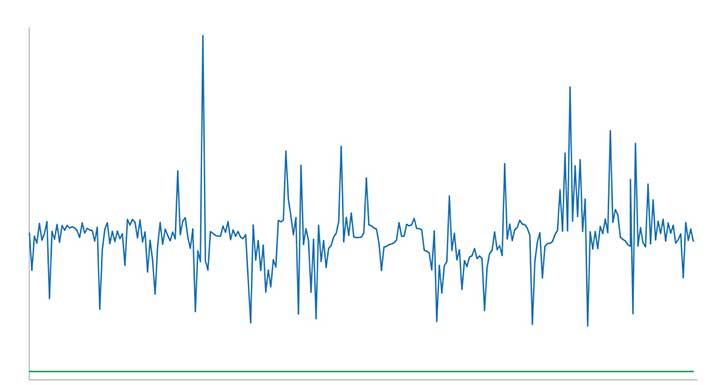
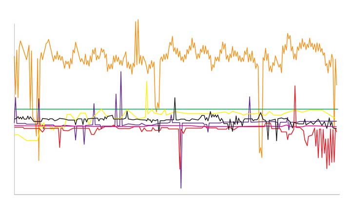
    One problem with time synchronization is the variability of network conditions. Network load, variable path delays and firewall settings can impact time quality on the local system. To illustrate this effect, we can use the time-quality monitoring feature of a time server with a built-in GPS receiver as its reference that is accurate to tens of nanoseconds. NTP can be used to compare it to another GPS time server on a local area network. The offset is around 15-20 microseconds (Figure 1).

    Figure 1. The comparison between two GPS time servers on the same LAN using NTP results in 15–20 microseconds offset. (Chart: Orolia)
    Figure 1. The comparison between two GPS time servers on the same LAN using NTP results in 15–20 microseconds offset. (Chart: Orolia)

    We connected the SecureSync time server to some of the most popular internet time servers. The variation result, shown in Figure 2, is as high as tens of milliseconds — 1,000 times worse than NTP across a local area network. If we assume all the time servers are accurate, then the difference is solely due to greater path delay and other dynamic conditions. This variation is enough to question the traceability of time from the internet.

    Figure 2. The comparison of internet time servers as measured by NTP on a local GPS time server. The scale is 1,000 times greater than in Figure 1. (Chart: Orolia)
    Figure 2. The comparison of internet time servers as measured by NTP on a local GPS time server. The scale is 1,000 times greater than in Figure 1. (Chart: Orolia)

    The internet obscures time traceability. Perhaps more important for a security-critical network is the validity of the source used by the time server that distributes time to your network. Time from GPS/GNSS signals is recognized as the most accurate, available and traceable time source.

    GPS/GNSS-based time servers are easy and simple appliances to add to the local network. Even when different GPS/GNSS time servers are deployed in different locations, they will provide the same time regardless of geography. What’s more, GPS/GNSS as a local time source can be monitored, so its logs can become part of the audit trail.

    Of the seven internet time servers monitored over a 24-hour period, 20 different time sources were identified. Less than half of the sources could be identified as coming directly from GPS/GNSS. In one case, GPS/GNSS time was distributed through three different time servers.

    The best practice of using NTP server pools is one reason why there are more sources than time servers. Server pools rotate among various internet time servers, each with their own source of time, to reduce the chance of one bad or unavailable time server catastrophically affecting the synchronization. But this is a problem for traceability. The source of time is not known, nor can it even be determined.

    Indeterminate source identification, indeterminate accuracy variation and the inability to log the resulting time synchronization calls into question the efficacy of getting time from the internet. Internet time servers are also subject to being spoofed (bad NTP data sent from a faked IP address) and to direct attacks, including NTP poisoning, replay and denial of service.

    When there is a business-critical need to trace time to an accurate source, a GPS/GNSS-based time server should be deployed on the local network.

  • Editorial Advisory Board PNT Q&A: Keeping data safe

    Editorial Advisory Board PNT Q&A: Keeping data safe

    What is the best way to protect data centers and mobile devices from spoofing and jamming?

    Ellen Hall
    Ellen Hall

    “After speaking to our head of engineering, Roger Hart, he explained this as something akin to ‘What’s the best way to achieve world peace?’ As the strengths and vulnerabilities of static and mobile devices vary considerably, the best solution will be achieved through a tailored application of algorithms, antenna siting and design, multi-constellation, multi-frequency and non-GNSS inputs.”
    Ellen Hall
    Spirent Federal Systems


    Allison Brown
    Allison Brown

    “Spoofing and jamming presents a very credible threat today to users of GPS for navigation and perhaps the greatest threat is vulnerability within our national infrastructure to spoofing of GPS timing. Congress, recognizing this threat, has tasked the Department of Transportation (DOT) in the National Timing Resilience and Security Act of 2017 to provide a backup for the timing component of the GPS. Specifically this backup is to ‘ensure the availability of uncorrupted and non-degraded timing signals for military and civilian users if GPS timing signals are corrupted or otherwise unavailable.’ Although the act directed the DOT that this system should be operational in two years (2019), little progress appears to have yet been made in deploying a backup timing system. This system not only would reduce vulnerability to spoofing for timing users, but could also be used by mobile users for detection of spoofing, allowing for national alerting when jamming or spoofing is detected. These alerts, tied with a quick response mechanism for law enforcement to take action, would provide an effective method for protecting all GPS users nationwide from jamming or spoofing.”
    Alison Brown
    NAVSYS Corporation


    Jean-Marie Sleewaegen
    Jean-Marie Sleewaegen

    “Take full benefit of multi-frequency multi-constellation redundancy.  Perform signal monitoring and authentication using advanced receiver architectures and signal-based protection (e.g., Galileo’s Open Service Navigation Message Authentication). Foresee non-GNSS redundancy to bridge gaps, such as precise clocks for data centers or IMUs for mobile devices.”
    Jean-Marie Sleewaegen
    Septentrio


    Members of the EAB

    Tony Agresta
    Nearmap

    Miguel Amor
    Hexagon Positioning Intelligence

    Thibault Bonnevie
    SBG Systems

    Alison Brown
    NAVSYS Corporation

    Ismael Colomina
    GeoNumerics

    Clem Driscoll
    C.J. Driscoll & Associates

    John Fischer
    Orolia

    Ellen Hall
    Spirent Federal Systems

    Jules McNeff
    Overlook Systems Technologies, Inc.

    Terry Moore
    University of Nottingham

    Bradford W. Parkinson
    Stanford Center for Position, Navigation and Time

    Jean-Marie Sleewaegen
    Septentrio

    Michael Swiek
    GPS Alliance

    Julian Thomas
    Racelogic Ltd.

    Greg Turetzky
    Consultant

  • GPS monitoring and crimes that shouldn’t have happened

    GPS monitoring and crimes that shouldn’t have happened

    Headshot: Tracy Cozzens
    Tracy Cozzens

    Law enforcement agencies have been quick to adopt GPS monitoring of offenders on parole or awaiting trial. An estimated 300,000 people in the U.S. are wearing ankle bracelets. Proponents say the systems enhance public safety, reduce prison costs and provide social benefits.

    However, technology is only as good as the people who use it, as a tragic case from Ohio illustrates. In February 2017, 21-year-old Reagan Tokes was kidnapped and murdered after leaving work in Columbus. The man convicted of killing her had been recently released from prison. Yes, he was wearing a GPS monitor, but no one was tracking his movements until after he robbed six people and killed Tokes.

    In response, Ohio lawmakers introduced a bill to improve real-time monitoring of parolees by shrinking the workload for parole officers, who now are responsible for 90 to 100 offenders at one time.

    In cases in Florida and New York, the system worked as intended and alerts were sent, but authorities took no action. In the Florida case, no one was on duty, despite the suspect having triggered more than 100 alarms.

    An offender in Syracuse, New York, was able to remove and reassemble his ankle bracelet in less than a minute, using techniques he learned when he watched the officers put the bracelet on him. Because of numerous false alarms, the monitoring company had set a five-minute limit before officers were notified, at the police department’s request. Having beat the monitoring system, the offender committed a murder.

    A nationwide investigation by ABC’s “20/20” news magazine program found at least 50 murders allegedly committed since 2012 by people ordered to wear monitored ankle bracelets.

    “Public safety is only as good as the supervising entity we provide our products to,” Jennifer White of monitoring company BI Analytics commented on “20/20.” Criminal justice experts say the monitoring system should not be used for anyone who is a risk to the public.

    While policymakers and law-enforcement authorities determine the most effective use of such systems —and how to address issues of monitoring response, overtaxed officers and tight budgets — the monitoring industry continues to improve the “tamper-resistant” devices as well as the services offered.

    After all, no one wants to live with a false sense of security.

  • Tersus launches dual-antenna GNSS receiver with heading

    Tersus GNSS Inc. has launched the David Plus — a dual-antenna GNSS receiver that offers centimeter-accurate positioning and heading. It is designed for intelligent transportation, construction, machine control, precision agriculture and navigation applications.

    David Plus is designed for efficient and rapid integration. The compact, lightweight receiver tracks GPS, GLONASS and BeiDou signals: GPS L1/L2, GLONASS L1/L2, BeiDou B1/B2 from the primary antenna, and GPS L1/GLONASS L1 or GPS L1/BeiDou B1 from the secondary antenna.

    The modular and flexible design can provide robust positioning and heading accuracy in a compact footprint for UAVs and other smaller autonomous projects.

    The David Plus GNSS receiver is built for outdoor environments with IP67-rated enclosure. Its compact palm-sized design makes it easy to integrate with various application systems.

    Four gigabytes of in-built memory are available to record data for post-processing.

    The David Plus GNSS receiver supports RTK positioning mode or RTK positioning + heading mode. It supports 384 channels. It’s easy to connect an external powerful radio for long range communication.

  • First development kits available for Septentrio’s mosaic GNSS module

    First development kits available for Septentrio’s mosaic GNSS module

    Septentrio’s Mosaic chip-level GNSS. (Photo: Septentrio)
    Septentrio’s mosaic chip-level GNSS. (Photo: Septentrio)

    Septentrio’s mosaic development kit is now available for testing and integration.

    Mosaic is Septentrio’s most compact, next-generation, high-precision multi-frequency GPS/GNSS module. The receiver brings precision and reliability of high-end multi-frequency GNSS to mass-market applications, the company said. It is designed to fit into the assembly-line process, which allows mosaic to be favorably priced for high volumes.

    Its lightweight and low power consumption helps extend the battery life of robotic devices, increasing operation time and efficiency. This makes mosaic suitable for applications such as robotics, automation, telematics and wearables.

    “We see a growing demand for reliable high-precision positioning,” said Chris Lowet, product manager at Septentrio. “A few years ago, this demand was concentrated in professional applications, for example survey, high-precision mapping and machine control. Today, with expansion of robotics, automation and IoT, a wide range of devices need high-precision positioning, from ag robots to IoT gateways to autonomous vehicles. We designed mosaic to answer these market needs.”

    Highlights of mosaic include:

    • Centimeter positioning in tough environments with multi-frequency, multi-constellation GNSS technology
    • Advanced Interference Mitigation (AIM+), which allows users to continue working despite radio interference from other electronic devices or jamming
    • Extensive corrections support for high-accuracy positioning: SBAS, PPP, SSR, RTK
    • RAIM+, integrity engine needed for safety-critical applications such as autonomous vehicles
    • Tracking all current and future GNSS satellite signals for enhanced real-time kinematic (RTK) performance and guaranteed RTK network compatibility
    • 100-Hz update rate, suitable for robotics and fast-moving vehicles.

    The development kit assists Septentrio customers with integrating mosaic into their system. It supports connectivity through internet, COM ports, USB 2.0 as well as an SD Card slot. The development kit can be requested here.

  • Jammers at dachas add to Russia’s ability to silence GPS

    A new investigative report by the Russian independent media group “The Project” into luxury dachas owned by high-ranking government officials revealed that most all include GNSS jammers among their amenities. Attempts by the journalists to photograph the dachas from the air using drones were routinely foiled by jamming.

    Most all nations’ military and security services have equipment that can block GPS and other satellite navigation signals over areas both large and small. Russia, though, has advanced this to a fine art which it regularly demonstrates.

    Russian forces always been proud of their electronic warfare capabilities. They see them as an essential counter to the effectiveness of western high-tech weapons. The news outlet “Sputnik” reported in 2015 Russian military claims that their ability in electronic warfare “makes aircraft carriers useless.”

    GPS is an underlying technology for many western weapons, and for much of the west’s critical networked infrastructure. As a result, jamming and spoofing GPS and other GNSS has long been a priority for Russian forces.

    In 1997 a Russian company offered a handheld four-watt GPS and GLONASS jammer that was effective at ranges of up to 150 to 200 kilometers. They also reported working with the Russian military on directional antennas for this jammer. These antennas would focus the disruption on a particular target while leaving most other users unaffected. The U.S. Army was sufficiently interested that, in 2002, they reportedly spent almost $200,000 to purchase the jammers for testing and evaluations.

    In 2016 Russia announced a program to add GPS jammers to more than 250,000 cell towers as a partial defense against a U.S. cruise missile attack.

    That same year a Moscow Times headline proclaimed, “Kremlin Eats GPS for Breakfast!” GPS users near the Kremlin had been regularly finding their cell phones reporting that they were 20 kilometers away at an international airport. This was playing havoc with Uber and Lyft drivers, as well as delivery services that depended upon satellite navigation. This spoofing, or sending false information to receivers, was reported to be an effort to protect the Kremlin and leaders from attack and surveillance by drones. Most drones are programmed at the factory with the locations of airports and to fly away from them. Convincing receivers near the Kremlin or elsewhere that they are really near an airport helps keep the area drone-free.

    Independent technologists in Moscow also reported that this spoofing employed a classic electronic warfare technique called “herding.” GPS L2 and L5 signals and Russia’s GLONASS satellite navigation signals were jammed. This forced receivers to rely upon the L1 signal which was spoofed.

    That same year this same kind of activity was also detected in the Black Sea. The RNT Foundation reported that over 600 ships had been “transported” to airport locations ashore. A subsequent report in 2019 by the non-profit group C4ADS revealed almost 10,000 instances of ships being spoofed in the Black Sea, the Baltic and in Russia’s west near Vladivostok between 2016 and 2018. It also drew a strong correlation between the movements of Russian President Vladimir Putin and the spoofing events.

    Russian jamming and spoofing has not been limited to its homeland. Vehicles, ships and aircraft in other nations, as well as in international waters and airspace, have been impacted. This despite Russia’s treaty obligations under the International Telecommunications Union radio regulations which provide that “All transmissions with false or misleading identification are prohibited.”

    The C4ADS report documented a massive Russian “smart jammer” operating almost continuously in Syria that had impact far beyond that nation’s borders. Smart jammers, by their definition, transmit messages that seem to be valid GPS signals, but with content that does not allow receivers to calculate a location. The operation in Syria has caused multiple warnings by the U.S. Maritime Administration of GPS disruptions in nearby international waters, and the European air traffic agency issuing warnings for international airspace in the eastern Mediterranean.

    The Baltic and Scandinavia have also seen Russian GPS jamming in recent years. In 2017 the Secretary General of NATO complained about Russian naval jamming that also degraded cell phone service in Latvia, Norway and Sweden.

    Early this year Norway protested Russian jamming in its far north, some of which was timed for NATO exercises. Five significant jamming events in the previous 17 months impacted, aviation, construction and other users.

    Russia regularly demonstrates that GNSS jamming and spoofing can be a useful tool for internal security and an effective method of power projection. Its actions, along with the portability and proliferation of jamming and spoofing equipment, are undoubtedly meant to remind the west that Russia can take away essential GNSS services at any moment with a just the flip of a switch.


    Dana A. Goward is the president of the Resilient Navigation and Timing Foundation, and is a regular contributor to GPS World.

  • Landviewer’s new change detection tool runs in a browser

    Landviewer’s new change detection tool runs in a browser

    A major use of remote sensing data is to compare images of an area taken at different times and identify the changes it underwent. With a wealth of long-term satellite imagery in open use, detecting such changes manually would be time-consuming and most likely inaccurate.

    To address this, EOS Data Analytics has introduced an automated Change Detection tool to its flagship product LandViewer, a cloud tool for satellite imagery search and analysis in today’s market.

    Unlike the methods involving neural networks that identify changes in the previously extracted features, the change detection algorithm implemented by EOS is using a pixel-based strategy, meaning that changes between two raster multi-band images are mathematically calculated by subtracting the pixel values for one date from the pixel values of the same coordinates for another date.

    This new signature feature is designed to automate a change detection task and deliver accurate results in fewer steps and in a fraction of the time needed for change detection in most image-processing software.

    Change detection interface: Images of Beirut city coastline selected for tracing the developments of the past years. (Image: LandViewer)
    Change detection interface: Images of Beirut city coastline selected for tracing the developments of the past years. (Image: LandViewer)
    Change detection interface: Images of Beirut city coastline selected for tracing the developments of the past years. (Image: LandViewer)
    Change detection interface: Images of Beirut city coastline selected for tracing the developments of the past years. (Image: LandViewer)

    Applications from farming to environmental monitoring

    One of the main goals set by EOS team was to make the complex process of change detection in remote sensing data equally accessible and easy for non-expert users coming from non-GIS industries.

    With LandViewer’s change detection tool, farmers can quickly identify the areas on their fields that were damaged by hail, storm or flooding. In forest management, satellite image detection of changes will come in handy for estimation of the burned areas following the wildfire and spotting the illegal logging or encroachment on forest lands.

    Observing the rate and extent of climate changes occurring to the planet (such as polar ice melt, air and water pollution, natural habitat loss due to urban expansion) is an ongoing task of environmental scientists, who may now have it done online in a matter of minutes. By studying the differences between the past and present using the change detection tool and years of satellite data in LandViewer, all these industries can also forecast future changes.

    Top change detection use cases: Flood damage and deforestation

    A picture is worth a thousand words, and the capabilities of satellite image change detection in LandViewer can be best demonstrated on real-life examples.

    Forests that still cover around a third of the world’s area are disappearing at an alarming rate, mostly due to human activities such as farming, mining, grazing of livestock, logging, and also the natural factors like wildfires. Instead of massive ground surveying of thousands of forest acres, a forestry technician can regularly monitor the forest safety with a pair of satellite images and the automated change detection based on NDVI (Normalized Difference Vegetation Index).

    How does it work? NDVI is a known means of determining vegetation health. By comparing the satellite image of the intact forest with the recent one acquired after the trees were cut down, LandViewer will detect the changes and generate a difference image highlighting the deforestation spots, which can further be downloaded by users in JPG, PNG or TIFF format. The surviving forest cover will have positive values, while the cleared areas will have negative ones and be shown in red hues indicating there’s no vegetation present.

    A difference image showing the extent of deforestation in Madagascar between 2016 and 2018; generated from two Sentinel-2 satellite images. (Image: LandViewer)
    A difference image showing the extent of deforestation in Madagascar between 2016 and 2018; generated from two Sentinel-2 satellite images. (Image: LandViewer)

    Another widespread use case for change detection would be agricultural flood damage assessment, which is of most interest to crop growers and insurance companies. Whenever flooding has taken a heavy toll on your harvest, the damage can be quickly mapped and measured with the help of NDWI-based change detection algorithms.

    Results of Sentinel-2 scene change detection: The red and orange areas represent the flooded part of the field,; the surrounding fields are green, meaning they avoided the damage. California flooding, February 2017. (Image: LandViewer)
    Results of Sentinel-2 scene change detection: The red and orange areas represent the flooded part of the field,; the surrounding fields are green, meaning they avoided the damage. California flooding, February 2017. (Image: LandViewer)

    How to run change detection in LandViewer

    There are two ways you can launch the tool and start finding differences on multi-temporal satellite images: by clicking the right menu icon “Analysis tools” or from the Comparison slider ‒ whichever is more convenient. Currently, change detection is performed on optical (passive) satellite data only; addition of the algorithms for active remote sensing data is scheduled for future updates.

    A guide to LandViewer is available here.

  • ESA focuses on PNT vs GNSS, wants proposals

    ESA focuses on PNT vs GNSS, wants proposals

    Logo: ESA

    OK, perhaps the headline is a tad misleading. But in addition to its natural preoccupation with Galileo, the European Space Agency (ESA) has begun thinking and talking about PNT as a service and user needs. In 2018, the European Commission issued a memo saying that GNSS alone was not sufficient for many critical and fail-safe operations.

    ESA is now seriously considering how Galileo and other systems can provide users the PNT services and resilience they need, regardless of whether the signals come from space.

    They have also issued a permanent Request for Proposals in this area. From their website:

    The goal is to maintain and improve the capability and competitiveness of the industry of the participating States in the global market for Satellite Navigation, and more broadly PNT technologies and services. In this context, the wider ambition towards the overall PNT sector is justified by the necessity to facilitate cross-fertilisation between space-based and terrestrial positioning technologies.

    This programmatic action will ensure the readiness of the industry to effectively respond to emerging market opportunities by focusing its activities on products ready for the commercial or institutional market.

    The development of ad hoc technologies and product development activities along the whole Satellite Navigation value chain and more broadly PNT products can be proposed by industry to develop products aligned with their plans for future exploitation.

    Activities therefore shall have been identified by industry as having clear potential for being applied in the area of PNT. The activities may address completely new products of a disruptive nature, may be an upgrading or improvement of an existing product or may address a continuation of an activity funded in another framework within another European institutional programme, a national programme or an industrial/academic research programme. The activities shall aim at resulting in a product ready for commercial exploitation.

    Implemented through a continuous open call capable of stimulating unsolicited proposals, the eligibility of which will be indicated by the relevant participating State (i.e. support letter). The pre-commercial nature of this programme element will call for a co-funding approach to be envisaged.

    Proposals must be from companies in the EU states of AT, CA, CH, CZ, DK, ES, FR, FI, UK, IT, IE, NO, NL, PL, PT, RO, SE and DE.

    Proposers must first establish a ESA-STAR/EMITS username and password. More information can be found here.


    Dana A. Goward is the president of the Resilient Navigation and Timing Foundation, and is a regular contributor to GPS World.

  • Allystar offers dual-antenna GNSS-aided INS platform

    Allystar offers dual-antenna GNSS-aided INS platform

    The Allystar INS Platform — the company’s latest technology — is a dual-antenna, multi-frequency, multi-GNSS inertial navigation system (INS) that delivers accurate and reliable position, velocity and orientation, the company said.

    It is designed for a wide range of autonomous vehicle applications under the most demanding conditions.

    Allystar RTK/INS Evaluation Board V1.0. (Photo: Allystar)
    Allystar RTK/INS Evaluation Board V1.0. (Photo: Allystar)

    The Allystar INS Platform combines high-grade, six-axis, temperature-calibrated accelerometers and gyroscopes with a multi-frequency, multi-GNSS engine, the HD9300 series. HD9300 is a dual-antenna chip-grade real-time kinematic (RTK) GNSS receiver for accurate positioning and heading.

    GNSS-aided inertial navigation systems are widely used in autonomous vehicles. However, high-accuracy multi-frequency multi-GNSS receivers are usually too expensive for mass-market applications. The Allystar HD9300 series is a mass-market multi-band chip-grade receiver that concurrently support all civil bands in all GNSS constellations (GPS/QZS L1&L2&L5&L6, BDS B1&B2&B3, GAL E1&E5, GLO L1OF/L2OF) with an integrated RTK engine to achieve centimeter-level accuracy.

    The Allystar INS platform contains an on-board sensor-fusion filter, navigation and calibration algorithms for different dynamic motions of land vehicles. Key features include:

    • multi-band multi-GNSS chip-grade receiver
    • dual antennas
    • integrated RTK engine (up to 2 centimeters)
    • 100-hz update rate
    • OBD data adapter.
    Allystar OBD Data Adaptor V1.(Photo: Allystar)
    Allystar OBD Data Adaptor V1. (Photo: Allystar)

    The Allystar OBD Data Adapter (v1.0) enables users to read and monitor various sensors built into cars, obtaining the real-time vehicle speed and gear signals from the OBD interface, and then output AT commands by serial port or SPI. When connected to the Allystar RTK INS platform, the adapter allows for outstanding navigation accuracy, especially in urban areas, helping to increase accuracy and reduce position drift.

    An evaluation kit — including platform board, antenna and OBD adaptor — will be available in August.

  • GPS Directorate seeks comments on revision notices

    GPS Directorate seeks comments on revision notices

    The GPS Directorate is soliciting public comments on several Proposed Interface Revision Notices (PIRNs). Comments are due June 25.

    Download or view the proposed changes on GPS.gov. Minutes from the Public Interface Control Working Group meeting held in May 2019 are also available on GPS.gov.

    • PIRN-IS-200K-001, v2: Proposed Changes to IS-GPS-200K – Leap Second and Earth Orientation Parameters
    • PIRN-IS-705F-001, v2: Proposed Changes to IS-GPS-705F – Leap Second and Earth Orientation Parameters
    • PIRN-IS-800F-001, v2: Proposed Changes to IS-GPS-800F – Leap Second and Earth Orientation Parameters

    Documents affected:

    • IS-GPS-200: Navstar GPS Space Segment / Navigation User Segment Interfaces
    • IS-GPS-705: Navstar GPS Space Segment / User Segment L5 Interfaces
    • IS-GPS-800: Navstar GPS Space Segment / User Segment L1C Interfaces

    Download the comment form on GPS.gov and send comments to [email protected].

  • Hexagon products expand reality capture options

    Hexagon products expand reality capture options

    The Leica BLK2GO. (Photo: Hexagon)
    The Leica BLK2GO. (Photo: Hexagon)

    Hexagon AB has introduced two new additions to its Leica BLK series. The Leica BLK2GO is a small, portable, integrated handheld-imaging scanner, and the Leica BLK247 is a 3D laser-scanning sensor for security surveillance providing continuous, 24/7 situational awareness.

    “Extending the BLK series continues Hexagon’s 20-year focus on revolutionising reality capture,” said Ola Rollén, Hexagon president and CEO. “These sensors are not only ground-breaking for their technical capabilities, but also for their practicality. The Leica BLK2GO can be taken anywhere, and the Leica BLK247 never sleeps.”

    Leica BLK2GO. The Leica BLK2GO introduces mobility for scanning complex indoor environments. The handheld-imaging laser scanner combines visualisation, lidar, and edge-computing technologies to scan in 3D while in motion, allowing users to be more agile and efficient in capturing objects and spaces.

    The BLK2GO has a wide range of applications from adaptive reuse projects in the architecture and design industries to location scouting, pre-visualisation, and VFX workflows for media and entertainment.

    The Leica BLK247. (Photo: Hexagon)
    The Leica BLK247. (Photo: Hexagon)

    Leica BLK247. The Leica BLK247 is designed for continuous 3D reality capture, extending capabilities for safety and security applications. The sensor provides real-time situational awareness through edge computing and LiDAR-enabled change-detection technology.

    Using artificial intelligence, the BLK247 can tell the difference between still and moving objects — such as a person walking who leaves a suitcase behind — and identify security threats to provide real-time alerts for both expected and unexpected changes.

    The BLK247 greatly enhances situational awareness within restricted or high-security spaces, as it eliminates the need for people to constantly monitor walls of security screens or smart building dashboards.

    The Leica BLK2GO and Leica BLK247 are among the many innovative solutions showcased this week at HxGN LIVE 2019, Hexagon’s annual digital technology conference.

  • CHC Navigation offers 8-inch professional tablet

    CHC Navigation offers 8-inch professional tablet

    Photo: CHC Navigation
    Photo: CHC Navigation

    CHC Navigation has launched its LT700 rugged Android tablet. The LT700 is designed to increase the efficiency and productivity of the mobile workforce in different industries and applications.

    An integrated GNSS module (GPS/GLONASS/BDS/SBAS) provides robust positioning performance. The LT700 dual-SIM 4G modem ensures fast and reliable connection with mobile teams.

    The LT700 tablet features an 8-inch sunlight-viewable touchscreen. It displays geospatial information system (GIS) data tables, complex vector and raster maps, or high-resolution pictures in direct sunshine and high-bright areas, CHC Navigation said.

    Unlike consumer-grade tablets, the L700 is intended for mobile field workers. Its industrial IP67 design withstands all-day use in harsh environments and conditions, and is protected from dust, rain, extreme temperatures and accidental drops from 1.2 meters. Rugged design, soft corner bumpers and long battery life provide the LT700 with the capability to perform uninterrupted for a complete working day.

    The LT700’s octa-core 2.2-GHz CPU supports running large maps and datasets without any lag or slowdown. Driven by Android 8.1 and bearing the GMS (Google Mobile Service) certification, the LT700 runs seamlessly the most common professional data collection applications available from the Google Play store.