Author: Tracy Cozzens

  • Polaris joins Mark43 on location-enabled dispatch for emergency departments

    Polaris joins Mark43 on location-enabled dispatch for emergency departments

    Polaris Wireless is partnering with Mark43 to integrate 3D location technology into computer-aided dispatch systems for public safety organizations. Polaris Wireless is a provider of software-based wireless location solution.

    The joint solution will enable police and fire departments to track personnel and assets with pinpoint location, including indoors and in high-rise buildings, with floor-level accuracy. It delivers enhanced situational awareness and improved operational efficiency, which helps save lives and additional costs.

    Mark43 Computer Aided Dispatch and Automatic Vehicle Location. (Screenshot: Mark43)
    Mark43 Computer Aided Dispatch and Automatic Vehicle Location. (Screenshot: Mark43)

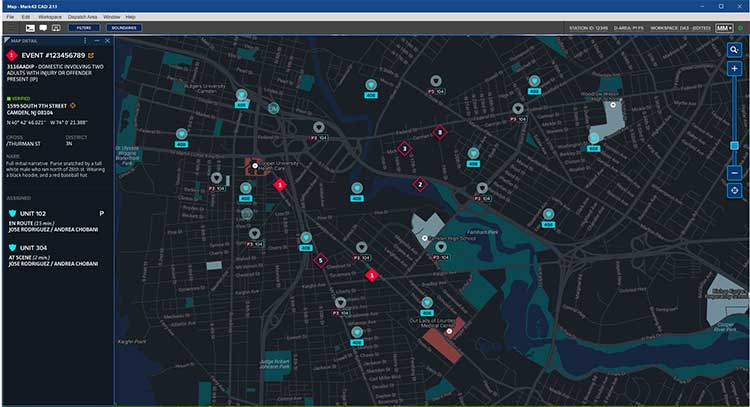
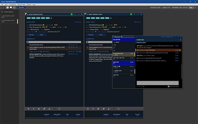
    Mark43 is a cloud-based public safety software provider. Its Mark43 CAD software provides mobile field units with precise information on laptops or tablets inside a vehicle. Built on AWS GovCloud, Mark43 works with police and fire departments to make sure web-connected units stay mobile in the cloud.

    With the addition of 3D location, command and control centers can direct firefighters to the correct floor in a structural fire or ensure SWAT teams enter at the correct floor of a high-rise building. In more routine situations, such as tracking officers or equipment in a large municipal headquarters, 3D location helps increase efficiency and allocate resources more wisely.

    Mark43 is purpose-built in the cloud to support interoperability with third-party systems and devices. This enables the Mark43 CAD to seamlessly integrate with the Polaris Wireless 3D Location Platform, which is cloud-based and available to application developers via a standard Android and iOS Software Development Kit (SDK).

    The platform relies on Polaris Wireless’ 3D location technology, which is able to locate devices on the vertical axis within 3 meters, floor level, utilizing all available signals and sensor measurements combined with the company’s patented algorithms.

    Screenshot: Mark43
    Screenshot: Mark43

    By operating independently, or “over the top,” of wireless carrier networks, the platform is universal, enabling applications to locate any device on any network — an important consideration when police and fire departments operate devices across several networks.

    “Giving command and control centers full visibility into first responders’ locations is crucial when it comes to emergency dispatch, where every second counts,” said Scott Crouch, Mark43 co-founder and CEO. “We are always aiming to integrate the best possible capabilities into our suite of offerings, and we look forward to working with Polaris Wireless to increase safety and efficiency for our first responders.”

    “Our 3D location is enabling new use cases in public safety applications with our partnership and integration into Mark43 CAD systems,” said Amir Sattar, senior vice president of operations for Polaris Wireless. “Dispatching police and firefighters to the precise location, including the correct floor number, represents a major advancement for public safety and a significant benefit for the communities they serve.”

    Polaris Wireless and Mark43 are exploring opportunities to trial the application with public safety organizations.

    Attendees at the NENA 2019 Event (June 14-19) in Orlando, Florida, can visit Mark43’s booth #321 to learn more.

  • Orolia’s new aircraft emergency beacon uses Galileo service

    Orolia’s new aircraft emergency beacon uses Galileo service

    Orolia’s Kannad Ultima-S emergency locator uses the Galileo Return Link Service. (Photo: Orolia)
    Orolia’s Kannad Ultima-S emergency locator uses the Galileo Return Link Service. (Photo: Orolia)

    Orolia is introducing a new product for commercial aircraft safety, the Kannad Ultima-S emergency locator transmitter (ELT).

    The Kannad Ultima-S is designed to be installed in the cabin of commercial aircraft or in its life raft. It is capable of notifying the crew about the launch of a search-and-rescue operation via Galileo Return Link Service (RLS).

    For passengers, installation of the Kannad Ultima-S means their flight can located accurately, with rescue following if an aircraft evacuation is needed.

    Orolia’s Kannad Ultima-S ELT was developed under a two-year contract through the European GNSS Agency’s Tauceti Project. Orolia says this is the first beacon to use the Galileo RLS.

    Other key features include:

    • Certified to the new lithium battery regulations to avoid the risk of battery fires.
    • A multi-GNSS receiver to accept multiple signals such as GPS and Galileo to detect the aircraft’s
      location faster and deploy rescue teams sooner than before.
    • Dual activation modes: manually or automatically upon contact with water.
    • An RLS option to notify the crew that the distress signal has been received and help is on the way (available on Galileo).
    • Multiple configurations available to install in aircraft cabins and life rafts. With a rugged, compact, and easy-to-install form factor, both versions can be installed through a carry-off bag or a mounting bracket and require little storage room.

    Orolia’s Kannad Ultima-S meets new and evolving EASA/FAA requirements related to ELTs and non-rechargeable lithium batteries documented under the RTCA DO-227A standard.

    “Orolia is dedicated to making air travel even safer than it is today with resilient positioning and aircraft location technology, featuring automatic, manual and remote activation modes to provide a complete ELT portfolio,” said Christian Belleux, Aviation Product Line director at Orolia. “We are excited to present aircraft operators with an affordable, reliable and state-of-the-art ELT solution for cabin modifications or linefit installations.”

    The new ELT benefits from the proven Cospas Sarsat infrastructure, which is being upgraded to provide highly accurate location data and nearly real-time reporting to search-and-rescue operators through global coverage.

    Kannad Ultima-S survival distress beacons complement Orolia’s Ultima family of next-generation ELTs, following the company announcement of the Global Aeronautical Distress and Safety System (GADSS)-compliant fixed Ultima-DT. Orolia provides aircraft manufacturers and operators with a complete solution for every ELT application.

    Orolia will exhibit at the Paris Air Show June 17-20, Hall 2B booth E32, where both new ELTs will be displayed for the first time.

  • ADS-B problem with GPS stems from faulty receiver

    ADS-B problem with GPS stems from faulty receiver

    Image: FAA
    Image: FAA

    ADS-B transponder problems on some aircraft stem from a bad update to a large class of aviation receivers, according to a blog on the Resilient Navigation and Timing Foundation website. The Air Traffic Control System Command Center issued a blanket waiver on June 9 for all flights having GPS/ADS-B issues with their transponders.

    According to various sources, the disruption briefly grounded entire fleets of regional jets. The resulting delays and cancellations rippled through the system.

    On June 9, the FAA published a map purporting to show an area of GPS signal degradation in the United States. However,  the disruption appears to affect only certain Collins Aerospace (formerly Rockwell Collins) GPS receivers, according to AIN Online.

    Collins Aerospace confirmed to AIN, “We identified a technical issue with our recently released GPS product(s) impacting availability, and have since determined the root cause and the resolution. We are engaging with our customers to ensure continued safe operational capability.”

    The affected GPS receivers are GPS-4000S part number 822-2189-100 and GLU-2100 part number 822-2532-100.  It appears that all aircraft worldwide these receives are not able to locate satellite position signals.

    “The absence of reports of problems from other modes of transportation and other industries certainly seems to justify refocusing from GPS signals to receivers as the root cause….” said the RNTF blog. “This is a good reminder for all that great signals in space are just one part of a ‘gold standard’ system. We also need unobstructed spectrum, great receiving equipment, and more than one source of great signals.”

  • USDOT plans to preserve 5.9 GHz spectrum for V2X safety

    USDOT plans to preserve 5.9 GHz spectrum for V2X safety

    The U.S. Department of Transportation (USDOT) convened leaders from state departments of transportation, stakeholders in academia, and representatives from the auto industry in Washington, D.C., to discuss the importance of preserving the 5.9 GHz spectrum for transportation safety.

    The 5.9 GHz band supports vehicle-to-everything (V2X), a wireless technology that enables data exchanges between a vehicle and its surroundings. Starting with advanced technology development and demonstrations about 20 years ago, America has deployed 54 operational V2X projects, improving safety today, with more in the pipeline.

    Vehicle manufacturers are planning to equip new cars with the technology. This next generation of intelligent transportation communications promises to improve safety for drivers and for vulnerable roadway users, such as pedestrians, bicyclists, disabled persons and transit users.

    The National Highway Traffic Safety Administration (NHTSA) estimates that full adoption of just two V2X safety applications would prevent about half a million crashes and save approximately 1,000 lives a year. As more safety applications are developed for vehicles, more lives could be saved.


    V2X will also support an efficient, safe, and smooth transportation system, with vehicles communicating with traffic lights to improve the flow of traffic. V2X applications such as dynamic traffic signal control and prioritization have the potential to reduce travel times by up to 27% and reduce fuel emissions.

    Photo: USDOT
    Link to video of CV2X demonstration in Hawaii in June. (Photo: USDOT)
  • ParaZero launches SafeAir Mavic following compliance testing

    ParaZero launches SafeAir Mavic following compliance testing

    The SafeAir System is a smart parachute system that monitors UAS flight in real time, identifies critical failures, and autonomously triggers a parachute.

    Photo: ParaZero
    Photo: ParaZero

    Drone safety company ParaZero Technologies Ltd., together with the Northern Plains UAS Test Site (NPUASTS), has completed the testing and compliance process for ParaZero’s SafeAir Mavic in accordance with U.S. ASTM F3322-18.

    The ASTM F3322-18 Standard Specification for UAS Parachutes was designed to enable civil aviation authorities (CAAs), like the Federal Aviation Administration (FAA), to determine whether a parachute system is airworthy for flight over human beings.

    Among other requirements, the standard defines more than 45 aerial deployment tests in various failure scenarios, verified by a third party.

    ParaZero’s ASTM-compliant SafeAir Mavic is designed specifically for DJI’s Mavic 2 series. The SafeAir System is a smart parachute system that monitors UAS flight in real time, identifies critical failures, and autonomously triggers a parachute. The system contains a flight termination system, a black box to enable post-deployment analysis, and a warning buzzer to alert people below of the falling drone.

    Safe UAV flights over people. The completion of the compliance process for the SafeAir Mavic will open the doors for UAS operators that are interested in the possibility of safe and legal UAS operations over people using the DJI Mavic 2. The FAA has granted a waiver for flight over people to an operator using ParaZero’s ASTM compliant SafeAir Phantom.

    Photo: ParaZero
    Photo: ParaZero

    The third-party validation provided by NPUASTS — an FAA UAV test site in North Dakota — played a crucial role in the ParaZero testing. The ParaZero project is in line with the work the NPUASTS is doing to promote the safe integration of UAS into the National Airspace System.

    The ability to safely operate UAS over people and in urban environments through waivers and approval is important for the growth of the UAS industry.

    “Third-party validation of the SafeAir Safety System for the Mavic is a necessary step for the industry to help advance operations of small UAS in various environments,” said Nicholas Flom, NPUASTS executive director. “With the partnership from ParaZero, we are one step closer to realizing routine flight operations over persons on the ground.”

    UAS operators can now purchase the ASTM-compliant SafeAir Mavic on ParaZero’s website. UAS operators will also receive compliance documentation with the purchase of the SafeAir Mavic system, including NPUASTS’ third-party testing report. This documentation and report will provide validation that operators can submit to the FAA with an operations-over-people waiver application.

    “Following the precedent setting waiver announced earlier this week, we are excited to launch our second ASTM compliant SafeAir System,” said Avi Lozowick, vice president of policy and strategy at ParaZero. “We are lucky to have partners like NPUASTS for this process; their aviation experience is second to none.”

  • Siemens integrates u-blox module into V2X test fleet

    The ZED-F9K turnkey solution minimizes the effort required to achieve decimeter-level positioning accuracy in automotive applications.

    Siemens has integrated the u-blox ZED-F9K high-precision dead-reckoning module into its Toyota Prius V2X (vehicle-to-everything) test fleet. Siemens carried out live demonstrations of the technology at ITS European Congress 2019 in Eindhoven, the Netherlands.

    As the only available source of absolute position, GNSS-based positioning plays a crucial role in advanced driver automation systems and driverless vehicles. The same is true in V2X communication, in which vehicles continuously share their location and other information with other traffic participants — cars and pedestrians — as well as surrounding infrastructure, improving road safety and reducing traffic congestion.

    V2X test vehicles typically determine their position using high-end GNSS  receivers. By opting to use the ZED-F9K, Siemens was able to align the performance of their test fleet with real-world conditions while also reducing the cost and the engineering effort required to develop their vehicles.

    Siemens conducted V2X tests using the u-blox ZED-F9K during ITS European Congress 2019. (Photo: u-blox)
    Siemens conducted V2X tests using the u-blox ZED-F9K during ITS European Congress 2019. (Photo: u-blox)

    “We’ve had a very positive experience with u-blox’s ZED-F9K high precision dead reckoning solution. The product delivered strongly from the initial design-in to the data and performance in our first tests,” said Igor Passchier, engineering fellow, Connected and Automated Driving at Siemens PLM Software.

    “Our collaboration with Siemens shows the extent to which the ZED-F9K turnkey solution saves OEMs time, cost, and engineering effort while providing decimeter-level positioning performance,” said Alex Ngi, Product Strategy for Dead Reckoning, Product Center Positioning, u-blox. “For us, it has also been a welcome opportunity to contribute to solving the challenges in the autonomous driving ecosystem.”

  • China plans to complete BeiDou-3 by 2020

    China plans to complete BeiDou-3 by 2020

    Photo: Xinhuanet
    Photo: Xinhuanet

    China is planning to complete its updated navigation constellation by 2020, according to China’s news service Xinhuanet.

    With 35 satellites, the completed BeiDou-3 will provide better coverage inside buildings and in urban canyons, according to researcher Jin Shuanggen, Shanghai Astronomical Observatory. Shuanggen was addressing the second Beidou Summit Forum.

    China has deployed three systems, BDS-1, BDS-2 and BDS-3, to provide accurate positioning and navigation services to the world, said Jin Shuanggen, a researcher at the Chinese Academy of Sciences, at the second China (Nanjing) BeiDou Satellite Navigation Application Expo and Beidou Summit Forum.

    The BDS system currently has 38 in-orbit satellites including 18 BDS-2 and 20 BDS-3.

    “Traditional satellites navigation service is hardly available in the interior of buildings, underground, underwater and other locations. The BDS system provides better accuracy in these locations,” he said.

    “BDS will play a large role as it is used in different scenarios including smart city, agriculture and meteorology, autopilot, and intelligent transportation,” said Jing Guifei, dean of BeiDou Belt and Road School of Beihang University.

    Along with the summit, a three-day exposition displayed BeiDou applications with more than 400 exhibitors. Fields covered included drones, autonomous ships, surveying and mapping, and intelligent robots and vehicles.

  • DroneShield to collaborate with Collins Aerospace on anti-drone tech

    Photo: DroneShield
    DroneGun, part of the DroneShield anti-UAV system. (Photo: DroneShield)

    DroneShield Ltd. and Collins Aerospace Systems, a unit of United Technologies, have entered a Memorandum of Understanding (MOU) to collaborate on opportunities with the Australian military, as well as globally.

    The intent is to add DroneShield’s counter-drone capabilities to Collins’ surveillance systems that its customers are already using.

    Collins Aerospace is a supplier of aerospace and defense products. In Australia, it holds current contracts within the Australian Defence Force.

    DroneShield is a public Australian company whose products include a suite of counter-drone technologies capable of protecting bases and forward-deployed groups against enemy drone threats.

    DroneShield’s products include DroneSentinel (a sensor fusion, multi-method drone detection system), DroneSentry (a combined detection and interdiction system), DroneGun Tactical (a handheld rifle-shaped drone-mitigation device) and RfPatrol (a body-worn drone detection device).

    DroneShield Chief Executive Officer Oleg Vornik commented, “Collins Aerospace has a leading position in the Australian defence market and we’re pleased to work together on opportunities that complement our capabilities to enhance customer value.”

    Updated Software.
     DroneShield has begun the rollout of firmware version 1.1 of its DroneShieldComplete software for its DroneSentinel and DroneSentry counter-drone systems.

    Enhancements include a number of features, such as pinpointing locations of pilots of detected drones. This allows for additional counterdrone procedures by customers, such as apprehending the pilots instead of neutralizing the drones directly.

    This is expected to be of a substantial benefit for customers who are not legally able to deploy drone countermeasures, as well as enabling them to deal with the cause of the drone-related issues.

    DroneShieldComplete 1.1 firmware, showing pilot detection capability with flags. (Photo: DroneShield Ltd.)

    DroneShieldComplete 1.1 firmware, showing pilot detection capability with flags. (Photo: DroneShield Ltd.)

    “The addition of the capability to locate and apprehend drone pilots without the need for taking down the drone has been developed in response to significant customer demand, and we expect this feature to be utilised by a number of our customers,” Vernik said.

  • Topcon launches rotary-wing UAV flight-planning software

    Topcon launches rotary-wing UAV flight-planning software

    Screenshot: Topcon
    Screenshot: Topcon

    Topcon Positioning Group has released its next-generation flight-planning system for its rotary-wing aerial UAV offering.

    The new Intel Mission Control Software is designed to facilitate automated flight planning, managing missions and data handling for the Intel Falcon 8+ drone – Topcon Edition and its available payload options.

    The software is designed to increase accuracy with advanced mapping features that allow operators to easily set project parameters and prepare missions using presets for 2D areas such as polygon, corridor and city grid, as well as 3D structures like towers, buildings and facades.

    “Operators can take advantage of 2D and 3D map views with the ability to import more precise project details and parameters, including restricted airspace, and support to adapt flight planning over difficult terrain,” said Charles Rihner, vice president of planning for Topcon Emerging Business.

    “It features the ability to import elevation, KML, GeoTIFF and Shapefiles for real life visualizations targeted for accurate planning. Plus, expanded preset options support automated flight including circle of interest, panorama, and 2D and 3D missions with automatic elevation and terrain adoption,” Rihner said.

    Additionally, the software includes automatic pre-flight safety and system checks while in mission planning. “Operators will receive detailed communication such as estimated battery life, airspace integration, ground and object safety limits, maximum dive and climb rate, minimum and maximum altitude, camera speed, number of images, camera storage, GSD check, and target photo coverage and quality,” Rihner said.

    The flight-planning software is also designed to improve data handling and export to support easier data processing.

    “It includes automated image matching and geotagging of images during data import, for increased time saving. Operators can preview and inspect the quality of the collected data, including individual images, as well as an overview of data coverage. Then, they can quickly and easily access and export flight data, and filter datasets for easier processing,” Rihner said.

  • Nepali survey team collects Everest height data

    The survey team set up the base station in Everest base camp. (Photo: Tshiring Jangbu Sherpa via Nepal24hours.com)
    The survey team set up the base station in Everest base camp. (Photo: Tshiring Jangbu Sherpa via Nepal24hours.com)

    A Nepali survey team made a successful ascent of Mount Everest to measure its official height.

    This is the first height survey conducted by the government of Nepal. The precise height of Mount Everest — now listed as 29,029 feet, or 8,848 meters — has been contested since the first survey by British officers in 1849.

    Nepal plans to end the controversy and declare both snow and rock height of the world’s tallest mountain.

    Chief Survey Officer Khimlal Gautam and surveyor Rabin Karki reached the peak of Mt. Everest on May 22 at 3 a.m. local time and collected data from a Trimble R10 GNSS receiver gifted from New Zealand.

    The surveyors stayed atop the peak for about 1 hour, 16 minutes, according to Nepal24hours.com.

    The final result of the official height measurement of Mt.Everest is expected within the next six months.

    “To make the observation of data on GNSS we spent one hour and 16 minutes in the summit which was a very challenging and trying time for us,” Gautam said. “We faced extreme difficulty mainly while descending from the summit.”

    According to Tshering Janbu Sherpa, guide leader of the survey team, the team faced difficulties because of the exhaustion of oxygen of one member, who was rescued during the descent.

    Besides a GNSS survey at the summit, teams conducted precise leveling, trigonometric leveling and gravity surveys. The GNSS survey will cover 285 points with 12 different observation stations, nine of which are in hills of Sankhuwasava, Bhojpur and Solukhumbu districts.

  • USGS, scientists test drone-based river analysis

    USGS, scientists test drone-based river analysis

    2019 Aquatic Airshow participants at Androscoggin River in Auburn, Maine, on May 1. (Photo: Mario Martin-Alciati, USGS)
    2019 Aquatic Airshow participants at Androscoggin River in Auburn, Maine, on May 1. (Photo: Mario Martin-Alciati, USGS)

    The U.S. Geological Survey (USGS) and independent scientists gathered this month in Auburn, Maine, to evaluate the use of sensor-mounted unmanned aircraft systems (UAS) to gauge stream stage, velocity, bathymetry and discharge.

    The technology is being evaluated and modeled to determine whether it will support the fast, accurate and safe measurement of rivers, especially when they are flooded or contain floating trees, ice or other debris.

    Close to two dozen hydrologic, geospatial and scientific experts gathered in what has been dubbed the “2019 Aquatic Airshow” to assess the technology. They were led by John Fulton of the USGS Colorado Water Science Center, Jack Eggleston of the USGS Water Mission Area Hydrologic Remote Sensing Branch, and Joe Adams and Sandy Brosnahan of the USGS National UAS Project Office.

    The USGS Water Mission Area works with partners to monitor, assess, research and report on a wide range of water resources and conditions, including streamflow, groundwater, water quality, water use and water availability.

    The testing involved equipping drones with noncontact sensors, including ground-penetrating radar for measuring river depths, doppler velocity radar and cameras with velocimetric analysis for measuring water surface velocities and calculating mean-channel velocities; and high-resolution cameras for photogrammetric mapping of surface topography and vegetation structure.

    All the evaluated sensors were equipped with GNSS receivers; some with RTK correction capability. Most of the drones used were equipped with a low-grade inertial measurement units (IMUs) for navigation.

    Team members from the USGS Water Science Centers in Colorado, New England and Virginia collected ground-truth river monitoring data with acoustic doppler current profilers deployed from a boat and multiple other surveying techniques to verify the accuracy of the drone-based stream data.

    Woolpert Chief Scientist Qassim Abdullah was one of two scientists from the private sector asked to participate in the airshow. Abdullah has more than 40 years of experience in analytical photogrammetry, digital remote sensing, and civil and surveying engineering.

    For the event, Abdullah devised a process in which the data collected by the drones underwent Pix4D triangular adjustment to produce three-dimensional models of the water surface and river edges to assist the modeling of river velocity using the drone-based doppler velocity radar and large-scale particle image velocimetry.

    USGS scientists are in the process of evaluating the data and modeling produced by this testing to conclude whether this technology will prove beneficial.

    Abdullah said the airshow was a success due to the varied contributions from each member of the team, their diverse backgrounds and their shared focus on water research.

    “This was a great example of how a public-private partnership can work together to activate and elevate necessary, groundbreaking technologies to address worldwide issues,” Abdullah said. “Airshow team members brought different perspectives, processes and applications to the testing, which not only proved essential for this project but will help with many others moving forward. I love working with this group and look forward to continuing to help advance these vital technologies.

  • Robinson helicopter tested as UAV for heavy lifts

    Robinson helicopter tested as UAV for heavy lifts

    A Robinson R22 helicopter was converted by UAVOS to an unmanned drone. UAVOS — which specializes in the design, development and manufacturing of unmanned vehicles and autopilot systems — successfully completed in-air programmed missions with the unmanned helicopter.

    The first flight this spring of the modernized helicopter lasted more than one hour and was performed in a fully self-piloted mode, reaching an altitude of up to 2,200 feet (670 meters). During the flight, all scheduled tests were performed including fully automatic take-off, enroute flight and landing. The tuning of UAV control settings was completed as well.

    The converted R22-UV is serving as a platform for research and testing for commercial UAV options. For instance, upcoming test flights will include cargo delivery of up to 330 pounds (150 kg) in automatic mode. Flights with a duration of 6+ hours using additional fuel tanks and a payload for monitoring the land surface are also planned.

    Besides that, UAVOS is planning to check operational limitations of the UAV during night flights and flights under severe weather conditions. A top priority is testing the possibility of using spraying equipment and to see whether R22-UV could serve agricultural purposes.

    Components installed. The UAVOS components installed in R22-UV helicopter included autopilot, servo drives, sensor system and additional backup power supply. During the conversion, the aircraft electrical system was upgraded, manual control was removed, the fuselage was altered for servo drives and components of the automatic control system installation. In addition, the pilot seats were removed and replaced by additional fuel tanks.

    Powered by a gasoline engine, the unmanned R22-UV helicopter is able to deliver cargo or carry payload with a total weight of up to 330 pounds (150 kg) with a maximum take-off weight of 1,400 pounds (635 kg).

    Heavy payloads. The converted aircraft has a practical ceiling of 13,780 feet (4,200 meters) and has a top speed of 189 kph. The UAV is designed to carry high-precision, heavy professional equipment 88 pounds (40 kg and more) for a wide variety of missions including lidar, synthetic aperture radar, heavy optical equipment or gas analyzers.

    The R22-UV can be operated in the regions without airfields, under severe weather conditions and during night-time, in the conditions with high stress risk for a pilot. The converted helicopter is useful for oil and gas companies that need to deliver cargo to hard-to-reach places, or where chemicals hazardous to humans are spread on the fields and forests. Operational limits for high-altitude flights and missions in heavy turbulence and high mountain regions should be defined after appropriate testing.

    The project was carried out jointly with King Abdulaziz City for Science and Technology (KACST), a scientific government institution of the Kingdom of Saudi Arabia.