Author: Tracy Cozzens

  • Hemisphere GNSS launches new positioning and heading boards

    Hemisphere GNSS launches new positioning and heading boards

    New OEM boards provide next-generation ASIC technology

    Phantom 40. (Photo: Hemisphere GNSS)
    Phantom 40. (Photo: Hemisphere GNSS)

    Hemisphere GNSS has released its next-generation digital and RF ASIC (application-specific integrated circuit) platforms, as well as three new positioning and heading OEM boards – the first products incorporating these technological advancements.

    Hemisphere’s new Lyra II digital ASIC and Aquila wideband RF ASIC designs optimize performance and provide the ability to track and process more than 700 channels from all GNSS constellations, the company said. Signals supported including GPS, GLONASS, Galileo, BeiDou, QZSS, SBAS and L-band signal support and tracking for AltBOC and BS-ACEBOC, BeiDou Phase 3, L5, and QZSS/LEX CLAS-D and CLAS-E.

    The new ASIC technology offers scalable access to every modern GNSS signal available.

    Vega 28. (Photo: Hemisphere GNSS)
    Vega 28. (Photo: Hemisphere GNSS)

    Also, the Lyra and Aquila ASIC technology provide the foundation for a new GNSS receiver chipset architecture that significantly reduces the number of board components required, thereby reducing complexity, improving reliability and lowering power consumption.

    The powerful technology platform also includes Hemisphere’s new Cygnus interference mitigation technology with built-in digital filtering capabilities and spectrum analysis. The Cygnus technology provides enhanced anti-jamming, interference detection, and mitigation.

    “The successful development of these new ASIC platforms is an important milestone on Hemisphere’s technology roadmap,” said Farlin Halsey, president and chief executive officer of Hemisphere. “Lyra, Aquila, and Cygnus-based technologies represent a significant investment and addition to our intellectual property portfolio — one that enables us to continue providing best-in-class GNSS performance and allows our customers and OEM partners to take their solutions to an even higher level.”

    Vega 40. (Photo: Hemisphere GNSS)
    Vega 40. (Photo: Hemisphere GNSS)

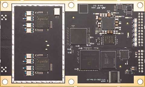
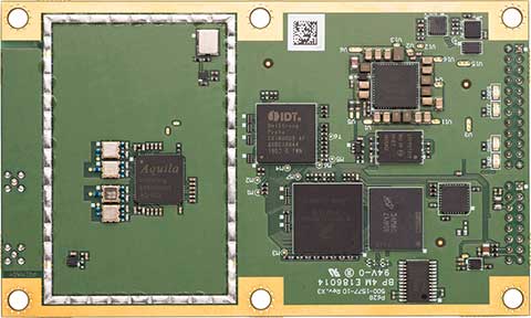
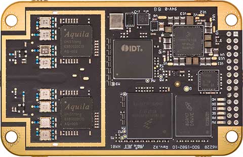
    The new Lyra, Aquila and Cygnus technologies will be made available with the new Phantom 40, Vega 28 and Vega 40 OEM positioning and heading boards.

    According to the company, the Phantom 40 positioning board is the first Lyra-based offering in a line of all-new, low-power, high-precision OEM boards. The Phantom 40 is a multi-frequency, multi-GNSS receiver that boasts 700 channels including access to Hemisphere’s Atlas GNSS global corrections network. The 60 mm x 100 mm module with 24-pin and 16-pin headers is a significant upgrade for existing designs using this industry standard form factor.

    The Vega 40 and Vega 28 are the first introductions in a new line of low-power, high-precision, positioning and heading OEM boards. The multi-frequency, multi-GNSS Vega 40 and Vega 28 GNSS receivers offer access to 1,100 channels including access to Hemisphere’s Atlas GNSS global corrections network.

    The Vega 40 is a 60 mm x 100 mm module with 24-pin and 16-pin headers and is an upgrade for existing designs using this industry-standard form factor. The Vega 28 is a 41 mm x 71 mm positioning and heading module, which represents the smallest GNSS OEM heading module Hemisphere has ever offered to the geospatial market.

    Hemisphere is integrating this new technology into other form factors and into many of its existing product portfolios and plans to introduce those products in the coming months.

  • NovAtel reduces size of anti-jam GAJT

    NovAtel reduces size of anti-jam GAJT

    NovAtel has added the GAJT-410ML to its GPS Anti-Jam Technology (GAJT) portfolio. Designed specifically for rapid integration into space-constrained military land applications, the easy-to-use system protects GPS-based navigation and precise timing receivers, including M-code, from both intentional and accidental interference, the company said.

    The GAJT-410ML is the next evolution of NovAtel’s battle-proven anti-jam technology. It maintains the high levels of interference rejection performance as in the larger GAJT-710ML system, but in a lower size, weight and power (SWaP) design.

    Photo: NovAtel
    Photo: NovAtel

    Working alongside the GAJT-410ML, the Power Injector Data Converter (PIDCTM) provides access to the jammer status and direction-finding (DF) information. It also provides clean power and data over the same cable that delivers the protected GPS signal back to the receiver, which reduces the need for costly platform modifications. The PIDC can be supplied in either an enclosure or board and is available to license for installation into third-party equipment.

    NovAtel Defence Segment Manager Dean Kemp noted, “Building on the success of our existing anti-jam portfolio, the GAJT-410ML is the first system to address the needs of smaller land-based platforms and add situational awareness capability to already high levels of mitigation performance.”

    “This product offers more choices for system integrators and end users to protect against GPS denied or constrained situations and delivers on our commitment to provide assured positioning anywhere,” Kemp added.

    Learn more about the GAJT-410ML anti-jam antenna or talk with NovAtel’s team of specialists at these upcoming trade shows:

    • The Special Operations Forces Industry Conference (SOFIC) – May 20 – 23, 2019, Tampa, FL USA
    • CANSEC – May 29 – 30, 2019, Ottawa, ON Canada
    • Joint Navigation Conference (JNC) – July 8 – 11, 2019, Long Beach, CA USA
    • International Defence Industry Exhibition MSPO (Canadian Pavilion) – September 3 – 6, 2019, Kielce, Poland
    • Defence & Security Equipment International (DSEI) – September 10 – 13, 2019, London, UK
  • Microsemi upgrades TimeProvider for 5G deployments

    Microsemi upgrades TimeProvider for 5G deployments

    Photo: Microsemi
    Photo: Microsemi

    Microchip Technology Inc., via its Microsemi subsidiary, has added the TimeProvider 4100 Release 2.0 to its Precision Time Protocol (PTP) PackeTime portfolio.

    TimeProvider keeps services operating through GNSS lapses due to vulnerabilities such as jamming, spoofing or loss of signal. It is also designed to meet one of the biggest 5G network deployment challenges —synchronizing higher volumes of more densely packed base stations.

    Microchip is also introducing Release 3.0 to its Integrated GNSS Master (IGM) family.

    TimeProvider 4100. Release 2.0 adds 10 Gigabit Ethernet support, a boundary clock operation mode that lowers operational costs, and other enhancements to improve how timing flows are distributed from multiple sources to a network’s base stations and other endpoints.

    The 72-channel GNSS receiver coupled with Microsemi’s patented active thermal compensation technology provides excellent accuracy of <10 ns RMS to UTC (USNO). With the time source provided through GNSS satellite input, it is essential to provide flexible support for constellations of choice depending on the region. TimeProvider 4100 supports GPS, GLONASS, BeiDou, Galileo, QZSS, and SBAS in its standard version.

    TimeProvider 4100 2.0 with its 10 GE expansion module has been selected by SK Telecom in Korea for its delivery of 5G services in the Seoul metropolitan area and Chungcheong province.

    IGM 3.0. For service providers that need to deploy more compact PTP 1588 v2 Grandmasters to fewer base stations closer to the network’s edge, Microchip is also introducing Release 3.0 to its Integrated GNSS Master (IGM) family.

    IGM 3.0 combines an IEEE-1588v2 PTP grandmaster with a GNSS receiver and antenna to simplify indoor or outdoor installations. Each of the three IGM 3.0 additions deliver precise time and phase as well as new capabilities enabled by IGM Plus hardware models with enhanced oscillators and GNSS receivers.

    The new oscillator options extend time-keeping holdover performance while the enhanced receiver speeds satellite signal acquisition and improves security by accessing more GNSS constellations simultaneously.

    The receiver upgrade option supports GPS, Galileo, QZSS and GLONASS, and is Beidou-ready. The IGM 3.0 software includes higher PTP capacity to 60 clients along with IPv6 support for traffic and management flows.

    TimeProvider’s Gateway Clock. Extending the TimeProvider 4100’s Gateway Clock operation mode with Microchip’s high-performance boundary clock (HP-BC) operation mode enables it to support the latest high-accuracy ITU-T Class C & D boundary clock standards. These standards dictate extremely accurate time transfer over optical networks so operators can use dense wavelength division multiplexing (DWDM) technology rather than dedicated fiber.

    Release 2.0 accommodates escalating bandwidth requirements of next-generation network devices through an optional expansion module that provides 10 GE interfaces. Expanded monitoring functions enable service providers to understand how time and phase performance is affected by network elements, the company added.

    PTP client capacity has been increased to 790 to provide the scalability that is critical for deployments in mobile network aggregation layers and new DOCSIS 3.1 Remote-PHY cable architectures.

    Both TimeProvider 4100 Release 2.0 and IGM Release 3.0 are managed with TimePictra, the centralized and unified management platform for the company’s family of precise timing systems.

  • Kolmostar releases low-power GNSS module JEDI-200

    Kolmostar releases low-power GNSS module JEDI-200

    JEDI-200 reduces the energy of getting one position fix by up to 150 times, according to the company.

    Photo: Kolmostar
    Photo: Kolmostar

    Kolmostar, a positioning technology company, has launched an ultra-low-power GNSS module at IoT World, which took place May 13-16 in Santa Clara, California.

    JEDI-200 reduces the energy for one position fix by up to 150x compared to traditional GNSS sensors, providing a positioning solution for location-based internet-of-things applications, the company said.

    JEDI-200 specification highlights include:

    • 10-mW ultra-low-power consumption (measured) @ 1 Hz navigation rate
    • 1-second ultra-fast time to first fix from cold start
    • 2-meter CEP high positioning accuracy
    • Supports GPS and Beidou constellations
    • 100-byte compressed ephemeris (EPH) to enable A-GPS with speedy download via LPWAN technologies such as LoRaWAN and NBIoT
    • High-performance cloud computing based on 50-byte raw position files for optimized radio transmission efficiency and minimum endpoint power consumption
    • Integrated SAW filter, stand-alone LNA and TCXO
    • 12 x 16 millimeter form factor for easy RF integration

    “JEDI-200 supports GPS as well as Beidou constellations,” said Tao Tong, co-founder and CEO of Kolmostar. “While achieving industry’s lowest power consumption, it helps our customers to achieve high accuracy even in dense urban canyon environment where existing GNSS modules on the market often drift due to multipath and other errors.”

    The JEDI-200 is designed specifically for IoT applications such as human and asset trackers (for bikes, scooters, vehicles, cargo, livestock, pets and more), smart wearables, smart farming and infrastructures,.

    Its reduced level of power consumption and its optimized efficiency with LPWAN technologies solve IoT endpoint deployment’s pain-point of needing frequent recharges or a large battery, enabling new possibilities in location-based IoT applications.

  • Rhode Island kicks off autonomous vehicle project using KVH

    Rhode Island kicks off autonomous vehicle project using KVH

    Little Roady Shuttle to aid research on autonomous vehicle technology

    Rhode Island officials have kicked off the Little Roady autonomous vehicle pilot project in Providence. The research project, which aims to evaluate autonomous mobility technology, begins service May 15.

    The free service will be the focus of a research project to help the Rhode Island Department of Transportation (RIDOT) better understand the opportunities and challenges that come with integrating this new technology into its transportation planning. The research will help improve transit and provide information for communities, the workforce and policymakers.

    The shuttles use a suite of sensors — including some from Middletown-based KVH Industries — and intelligent software to help the vehicle understand its environment and how to safely navigate through it.

    The entire fleet has undergone 500 hours of testing both at Quonset Point this winter and in Providence this spring, which included detail mapping so the machines know every inch of its route and how to operate in a variety of traffic and weather conditions.

    The Little Roady shuttles are provided by May Mobility Inc., which entered into a public-private partnership with RIDOT in the fall of 2018, following a competitive request-for-proposals (RFP) process.

    “It’s always exciting when Rhode Island has an opportunity to lead the way in cutting-edge green technology,” said Governor Gina Raimondo. “This project will provide valuable data for states across the country as we move beyond conventional transit services to provide better, cleaner, and more accessible transportation for all.”

    The experimental service will operate seven days a week, from 6:30 a.m. to 6:30 p.m., with 12 stops between Olneyville Square and Providence Station. The Little Roady shuttles will run on a continuous, 5.3-mile loop on low-speed roads with an average wait time of about 10 minutes. Trip time will be about 20-25 minutes each way from Providence Station to Olneyville Square.

    “The kickoff of this service and research project is another achievement for the new DOT,” RIDOT Director Peter Alviti, Jr., said. “Our transportation agency has literally been rebuilt to effectively deliver safer roads and bridges while simultaneously studying and piloting new technologies. In doing so, we’ll keep Rhode Island well ahead of the curve for the transportation solutions of tomorrow.”

    “By partnering with RIDOT, May Mobility is showing how our self-driving shuttles can be part of a sustainable future for communities,” said Edwin Olson, CEO and founder of May Mobility. “Our environmentally-friendly shuttles aren’t just fun-to-ride, they can increase access and convenience for a large number of people.”

    The cost of the project, including the research component, is $1.2 million. This includes funding for an $800,000 public-private partnership with May Mobility, a $500,000 grant awarded by the R.I. Attorney General’s Office as part of a settlement with Volkswagen, federal research funds through the Federal Highway Administration, and matching state funds. RIDOT’s contract with May Mobility includes options to extend the service for an additional two years.

    The debut of the autonomous vehicles is the latest step in a multi-agency effort called the Rhode Island Transportation Innovation Partnership (TRIP), which RIDOT launched in 2017. TRIP also includes a research component, with the goal of studying autonomous mobility solutions, ridership, workforce impacts, environmental impacts, and technology adoption, among others.

    TRIP includes many partner agencies and governmental entities, including the City of Providence, the Rhode Island Public Transit Authority (RIPTA), the Rhode Island Division of Motor Vehicles and the Quonset Development Corporation. The research team is made up of representatives from Brown University, 3×3 Design, Stae, and Bits and Atoms.

    May Mobility, a Michigan-based startup, is developing self-driving shuttles for college campuses, corporate clients, and central business districts. It launched a private corporate service in Detroit in June 2018 and a public service in Columbus, Ohio, in December 2018. It has also entered into an agreement for public service in Grand Rapids, Michigan. The company has hired fleet attendants and managers from Rhode Island and has set up a local operations office in Providence.


    Featured photo: Rhode Island Department of Transportation (RIDOT).

  • Autonomous Snowbot Pro hits the sidewalk

    Autonomous Snowbot Pro hits the sidewalk

    Photo: Left Hand Robotics
    Photo: Left Hand Robotics

    The autonomous SnowBot Pro is ready to clear your walkways. Offered by Left Hand Robotics and guided by Swift Navigation, it is a commercial-grade, robotically driven product for snow removal.

    Driving autonomously, SnowBot Pro clears snow from walkways with a 56-inch-wide rotating brush, reducing the number of hand shovelers or snow blower operators needed by up to 80 percent, the companies said. Various front and rear attachments allow for a multitude of tasks, such as snow removal in the front and deicing in the rear. It also reduces potentially costly slip and fall insurance claims.

    The SnowBot is programmed and controlled remotely from the cloud via an online dashboard or mobile app, and follows its programmed path using GPS, accelerometer and gyroscope technologies for navigation.

    Sensors detect any obstacles and can instruct the robot to stop to avoid collisions and send instructions about how to bypass obstacles. Location, weather and robot status data is recorded in real time, along with before and after photos. The detailed recording helps minimize insurance and risk-management costs while providing customers with proof of work.

    The robot has to navigate precisely, avoiding potentially damaging landscaping, walls, curbs and other obstacles along sidewalks and walkways. Centimeter-level GNSS ensures it avoids obstacles and stays on its designated route. Finding a reliable real-time kinematics (RTK) GNSS solution was critical given that many sidewalks are near buildings and underneath trees.

    After evaluation, Left Hand Robotics chose Swift Navigation’s Piksi Multi. Its centimeter-level accuracy keeps the robot in its designated path and allows its base robot platform to navigate in a variety of environments, whether in lines (sidewalks, bike paths) or large open areas (fields, parks). The Piksi Multi also retains a GNSS fix in challenging conditions and environments.

    Once Swift’s ruggedized Duro receiver was launched — and could be used by customers as a base station that was required for RTK — Left Hand Robotics had a complete offering for customers, which it launched in the winter of 2018–2019.

    A Piksi Multi is installed in each SnowBot Pro, and its Path Collection Tools (tools customers use to collect the initial path data the robot will follow) and Duro is used as the base station controlling the SnowBot Pro robot.

    The SnowBot Pro – the first self-driving snow clearing robot for commercial use. from Left Hand Robotics on Vimeo.

  • Raytheon to start global installation of GPS OCX receivers

    Raytheon to start global installation of GPS OCX receivers

    Raytheon Company’s GPS Next-Generation Operational Control System program, known as GPS OCX, completed final qualification testing of the system’s modernized monitor station receivers, which are now ready to be installed around the world starting in August.

    GPS OCX is the enhanced ground control segment of a U.S. Air Force-led effort to modernize America’s GPS system.

    “The modernized receivers give GPS OCX the ability to receive and decrypt all GPS III military and civil signals, a critical capability the current system doesn’t have,” said Dave Wajsgras, president of Raytheon Intelligence, Information and Services. “Monitor station receiver installation keeps us on track for full system delivery by our June 2021 contractual deadline.”

    The modernized receivers will measure and monitor legacy military and civilian signals sent by the current GPS satellite constellation plus the new signals sent by the next-generation GPS III.

    The receivers will also feed correction models at the master control station, giving U.S. Air Force satellite controllers the information necessary to make key adjustments to maximize accuracy.


    Feature photo: GPS ground antenna at Schriever Air Force Base, home of the 50th Space Wing. (Photo: Raytheon)

  • Diving into digital mapping history with OpenStreetMap

    Diving into digital mapping history with OpenStreetMap

    A European region in 2015. (Image: OpenStreetMap)
    A European region in 2015. (Image: OpenStreetMap)

    A tool developed by Mapbox explores “10 years of OpenStreetMap.” During that decade, hundreds of thousands of people mapped 25 million miles of roads in every country in the world.

    The internet tool uses a slider to show the data change over time. You can see additions and edits as they come online over the decade — a fascinating look at the intricate information that has been compiled. When a user drags the slider to the left, it’s easy to see how scant the information was only a few years into OpenStreetMap’s existence (the image at right shows the same European region in 2009 as the image at the top in 2015).

    The same European region in 2009 as the image at the top in 2015. (Image: OpenStreetMap)
    The same European region in 2009 as the image at the top in 2015. (Image: OpenStreetMap)

    After GPS and GNSS, OpenStreetMap ranks high in the movement to make geographic information accessible. OpenStreetMap is a community-driven project to create the most detailed, correct and current open map of the world.

    When Steve Coast began the project in 2004, map data sources were few, and largely controlled by private companies and the government. Coast changed the rules by creating a wiki-like resource of the entire globe, which everyone could use. Today, 5.2 million people use OpenStreetMap.

    OpenStreetMap democratized mapping: all a contributor needed was time and a computer connection to add data about their country or their neighborhood. Besides GNSS, contributors use aerial imagery and low-tech field maps to verify that OSM is accurate and up to date. Others dedicate their energies to humanitarian projects, including disaster response following the Haiti hurricane and aiding South Sudan and Syrian refugees.

  • Using consumer-grade sensors for precise positioning

    By Urs Niesen, Jubin Jose, Xinzhou Wu, Qualcomm Technologies Inc.

    Emerging automotive applications require reliable but at the same time low-cost positioning solutions. In this paper, we present such a solution by fusing the measurements from several consumer-grade sensors using a tightly coupled centralized filter.

    The sensors used are a single-frequency GNSS receiver providing GPS and GLONASS pseudoranges and GPS carrier-phase measurements, a micro-electro-mechanical (MEMS) inertial measurement unit (IMU), a monocular camera, wheel-speed and steering-angle sensors.

    We also employ vehicular constraints, integrated as pseudo-measurements. The centralized fusion architecture allows sensor cross-calibration and improves outlier detection. The filter runs in real time on the target platform, producing pose estimates at 30 Hz. Through extensive experimental evaluations, we demonstrate positioning accuracies of sub-meter 95-percentile horizontal errors even in GNSS-challenged deep-urban scenarios.

    Conflicting Requirements. Accurate positioning is a requirement for several emerging vehicular applications such as advanced driver-assistance systems (ADAS) and autonomous driving. Positioning solutions for these applications face two competing constraints. To be technically viable, the computed position estimate needs to be reliable in scenarios ranging from open sky to deep urban, with less than 1-meter 95-percentile horizontal error as an often-mentioned target. To be economically viable, the system needs to be built from consumer-grade components.

    We reconcile these conflicting requirements by fusing measurements from several low-cost sensors into a single pose estimate using one centralized extended Kalman filter (EKF). A multi-constellation single-frequency GNSS receiver provides GPS pseudorange and carrier-phase measurements and GLONASS pseudorange measurements. These are combined in a tightly coupled integration architecture with a consumer-grade MEMS IMU used to produce the reference navigation solution.

    Tight integration enables outlier rejection directly for the raw GNSS measurements. This is crucial in deep-urban scenarios, since many or most raw GNSS measurements could be outliers in these conditions. We use a monocular camera and vehicular sensors, providing four wheel-speed measurements and a steering-angle measurement, as additional aiding sensors.

    Constraints. Finally, vehicular constraints are integrated as pseudo-measurements. These sensors have very different noise sources and failure modes, which allows cross-calibration and improves failure and outlier detection. Given the tightly coupled integration in a single EKF, the filter state is quite large and can reach more than 100 dimensions. Despite its size, we are able to run the filter in real time and on target, producing pose outputs at a rate of 30 Hz.

    We report the result of extensive experimental evaluations in different scenarios ranging from open sky with good satellite visibility to deep urban with long stretches of no or only limited satellite visibility. In each of these scenarios, we obtain the target accuracy of sub-meter 95% horizontal positioning error.

    We show that, in the benign open-sky scenarios, GPS and IMU sensors are sufficient to achieve the target accuracy. However, in challenging deep-urban scenarios, all the integrated sensors are required to attain reliable sub-meter positioning performance.

    Sensors and Components. We use Qualcomm SiRFstarV 5e B02 GNSS chipset, a low-cost commercial GNSS product, connected to a NovAtel GPS-702-GG dual-frequency GPS+GLONASS Pinwheel antenna, the only component not consumer-grade, to separate impact of a specific antenna on performance. We plan to evaluate low-cost antennas in the future. We use a TDK InvenSense low-cost MEMS 6-axis IMU (MPU-6150) and a vehicle interface with vehicle sensors through the controller area network bus. Accurate timestamping for tightly coupling sensor measurements is provided by a custom sensor sync board. The processor is a Qualcomm Snapdragon 820 automotive platform for real-time computation. (Qualcomm SiRFstar and Qualcomm Snapdragon are products of Qualcomm Technologies, Inc. and/or its subsidiaries.)

    This paper was presented at ION-GNSS+ 2018.
    .

  • Auterion enables Impossible Aerospace to launch new US-1 drone for first responders

    Auterion enables Impossible Aerospace to launch new US-1 drone for first responders

    Photo: Impossible Aerospace
    Photo: Impossible Aerospace

    Auterion and Impossible Aerospace are collaborating to bring to market the US-1 UAV, which has a two-hour flight time.

    Auterion is the provider of Auterion Enterprise PX4, an open-source-based, enterprise operating system for drones. Impossible Aerospace is Silicon Valley, California-based drone manufacturer on a mission to assemble the highest performance electric aircraft.

    “During critical public safety incidents, real-time intelligence from a UAV is extremely important. This is why the two-hour flight time of the US-1 is a clear necessity.” said Spencer Gore, CEO of Impossible Aerospace. “We turned to Auterion for software because their operating system is auditable and trusted for government applications.”

    “Public safety organizations can now field a drone with government solicited, cyber-secure and trusted software that enables the drone to stream real-time footage to a command center,” said Kevin Sartori, co-founder of Auterion. “Choosing Auterion and its open-source, open-standards approach will greatly simplify the integration of the US-1 into the IT-infrastructure of public safety organizations.”


    Thousands of professional drone pilots and businesses around the world count on open-source flight control software PX4, which was created by Auterion co-founder Lorenz Meier in 2011 and has evolved into a global developer community. Similar to Red Hat, Auterion builds the open-source infrastructure so that drone manufacturers can go to market faster with new products flying trusted software.

    The US-1 quadcopter made its public safety debut in February with a California-based police force. The drone gives police agencies a new category of assets that sit between lower-end drones and police helicopters. This enables a wider usage of aerial imagery and reduces the cost for first responders at the same time.

  • CHC Navigation opens NA headquarters in Arizona

    CHC Navigation opens NA headquarters in Arizona

    Photo: CHC Navigation
    Photo: CHC Navigation

    Shanghai-based GNSS technology and solutions company Shanghai Huace Navigation Technology Ltd. — known as CHC Navigation — has opened a North American subsidiary, CHC Navigation USA Corporation, in Scottsdale, Arizona.

    CHC Navigation was established in 2003 and was ranked as one of China’s top GNSS and RTK technology and solutions companies in 2017. It has customers in more than 100 countries worldwide and has been providing GNSS and RTK products and solutions to the US marketplace since 2009.

    The establishment of a North American head office in Scottsdale illustrates CHC Navigation’s ongoing commitment to expanding its products, services and customer support in the U.S. and North American marketplaces.

    CHC USA will warehouse, sell and service from Scottsdale all of its products to its dealer and OEM network of customers across North America. With the new U.S. presence, CHC USA will be able to respond more quickly to its dealer and customer order requests and service requirements.

    CHC USA specializes in CORS GNSS base-station infrastructure, deformation monitoring, surveying and mapping. With new 3D lidar scanning and hydrographic unmanned survey vessels launching later this year, CHC USA’s North American office and team members will continue to focus on ensuring a great customer experience.

    “On the heels of strong CHC Navigation growth in the US in 2018, the time was right to establish a domestic US sales and service office and warehouse with a local team of positioning industry professionals,” said George Zhao, CEO of CHC Navigation. “Our U.S. and Canadian customers have been very supportive of CHC Navigation over the years and our focus will continue to be on providing industry leading products and services to our valued North American dealers and customers,” added Phil Gabriel, President of CHC Navigation USA.

  • Topcon’s Sitelink 2.0 offers Haul Truck application

    Topcon’s Sitelink 2.0 offers Haul Truck application

    Sitelink 2.0. (Photo: Topcon)
    Sitelink 2.0. (Photo: Topcon)

    Topcon Positioning Group is offering a new edition of its real-time 3D job site monitoring and management system, Sitelink 2.0. The update includes a new pay-as-you-go point-based service model, new features to Sitelink Support Desk, as well as a new Haul Truck application, the company said.

    Version 2.0 includes a newly redesigned web portal that features a consumption-based “Service Point” investment model.

    “We are introducing a completely new way to service our customers that allows them to take advantage of a pay-as-you-go account-based system rather than year-long pre-paid subscription-based plans,” said Murray Lodge, senior vice president, construction. “With no expiration date on the Service Points, contractors can be assured their investment will be protected in their personal account and allocated when it best suits their needs.”

    Also, new to the service includes remote configuration functionality in Support Desk. It allows Topcon support personnel to directly access and configure receiver components on connected machines, while simultaneously retaining an active remote session of the 3D-MC machine control software.

    “We have made support more efficient with less downtime for operators with our team having the ability to go straight into the configuration settings for receivers and make adjustments, minimizing work stoppage on the site,” said Lodge.

    The latest version also includes a new Topcon Haul Truck application, which utilizes an Android or iOS app that can be installed on a phone or tablet. It is designed to provide a complete and easy-to-use cloud-based, haul management and reporting system with real-time visibility.

    “The new Haul Truck app provides productivity statistics for each haul, including the counts, average distances and the time it takes to complete the process — all within a geofenced pickup site and unloading zone. It is simple to use — drivers come onto the site, quickly enter basic info and get to work,” Lodge said. “With 3D map imagery, operators can view where the load is being picked up and the path it takes to unload and return, and it automatically records for reporting.”