The application, built using the TerraGo Magic platform and available today from BAE Systems, offers iOS, Android and web apps that make it easy to securely capture and share field reports from any location.
With GXP InForm, users can customize forms, maps and workflows so field applications can be quickly configured and instantly deployed to support any operation, in any location.
GXP InForm’s mobile features, including basemaps and forms, are available without network connectivity so personnel can get the job done in the most remote locations and demanding conditions. When a network connection is available, GXP InForm enhances situational awareness for all stakeholders with the bi-directional flow of information between headquarters and on-site personnel.
“We constantly look for ways to help our customers extend the value of GXP Xplorer across the enterprise and improve the quality of geospatial intelligence for all stakeholders,” said Damon Brady, director, product development and programs at BAE Systems. “With GXP InForm, mobile users get access to actionable imagery, while command units gain access to site reports, photos and videos that enhance the fidelity of their common operating picture.”
“We’re proud of this collaboration to build GXP InForm,” said Dave Basil, president and CEO at TerraGo. “It’s the result of a long-running and successful partnership with BAE Systems that goes back to 2008. The combination of GXP Xplorer, as an open data-management platform, and GXP InForm, as a customizable reporting application, provides great value to our customers that need to leverage vast geospatial data sources and tailor field workflows to all types of operations and missions.”
TerraGo is offering a webinar at 1 p.m. ET on Feb. 21, with a discussion and demonstration of GXP InForm. Register here.
Averna is offering a wideband RF record and playback platform. The RP-6500 records and plays back up to 500 MHz of RF spectrum — from 9 kHz to 6 GHz — to test multi-constellation GNSS applications, the company said. The system can also capture other signals such as Wi-Fi, V2x, spectrum sharing and cellular applications.
The robust system fits into a car trunk for driving/recording applications, and syncs with both a GPS and Averna’s DriveView software for synchronized location and video capture that is time-aligned.
Preloaded with RF Studio, a state-of-the-art workflow tool, the RP-6500 Series lets users quickly set up recordings, add contextual data, visualize weak signals and analyze the collected RF environments to validate and fine-tune designs and products.
“The RP-6500 is a complete RF Record and Playback platform–it’s been designed and built from the ground up to be all-in-one,” said Alex Pelland, product line manager at Averna. “The hardware ticks all the boxes for serious users, and we’ve bundled it with RF Studio, so that all users can achieve simple configuration, file management, and visualization as well.”
Key Features and Benefits
Easy-to-use RF Studio user interface
500 MHz wide instantaneous bandwidth
Covers most common wireless protocols from 9 kHz to 6 GHz
High dynamic range (14 bits, ~ 86 dB)
Form factor allows rack mounting or car trunk portability
Time-synchronized capture of RF, signals, and messages
Helix Technologies Ltd. has been awarded a significant contract by the European Space Agency (ESA) to develop its next-generation GNSS antenna — a multi-frequency antenna optimized for the advanced Galileo E1 Alt-BOC and wide-band E5 Alt-BOC waveforms for use in driverless cars.
The antenna, to be developed under the ESA’s Navigation Innovation and Support Programme (NAVISP), will provide enhanced performance due to its dielectric, multi-filar construction. It will also be optimized to take maximum advantage of the Galileo E5 Alt-BOC waveform, which enables significantly improved measurement accuracy, precision and multipath suppression over conventional GNSS signals.
Learn more about the Helix Technologies antenna in our February issue article here.
“In order to achieve the 10-centimeter accuracy that is required for autonomous vehicle lane-level positioning within challenging urban multi-path propagation conditions, there is a need both for a significant improvement in current GNSS antenna performance and to fully exploit the advanced Alt-BOC waveforms transmitted by Galileo,” said John Yates, managing director of Helix Technologies.
The GNSS antenna, which will also be capable of optimized operation with the GPS L1 and L5 M BOC signals, is aimed at the automotive and consumer markets, and the company is targeting the third quarter of this year for the manufacture of prototypes.
Independent testing and evaluation of the vehicle-mounted antenna performance will be conducted in the challenging multipath environments of the high-rise financial districts of the cities of London and Shanghai.
Making cities cleaner, providing better services and housing, and decreasing pollution are all achievements of nine cities recognized for using data to improve citizens’ lives.
In January, Bloomberg Philanthropies announced that nine cities have achieved What Works Cities certification, a first-of-its-kind national standard of excellence in city governance.
What Works Cities certification rates how well cities are managed by measuring the extent to which city leaders incorporate data and evidence in their decision-making.
Having shown leadership in data-driven government, the nine cities will receive additional expert assistance from What Works Cities to accelerate progress and deepen their leadership in using data.
Bloomberg Philanthropies launched What Works Cities in April 2015 to drive the use of data in U.S. municipal governance and to facilitate the exchange of best practices. It has reached its initial goal of bringing 100 mid-sized American city partners into the program. The nine certified cities were selected from more than 115 applications.
Los Angeles was awarded Gold Level, and eight other cities received Silver Level certification. No city has yet achieved Platinum, the highest level.
Accomplishments of each of the certified cities can be found here; below is a snapshot.
Gold Level: Los Angeles
Los Angeles has demonstrated a strong commitment and impressive track record with data-driven initiatives, according to Bloomberg Philanthropies.
Immediately upon assuming office, Mayor Eric Garcetti embraced an aggressive approach to data and analysis to better understand and map the most pressing issues in Los Angeles. Now in his second term, the mayor is using the foundation created by these efforts to develop a system-wide, evidenced-based approach to address the problems of affordable housing, crime, traffic and pollution.
Through its Data Science Federation, the city is also partnering with local universities to accelerate its use of data-driven tools at the same time that it is creating a pipeline to bring new talent into local government.
Among the major accomplishments cited:
CleanStat. In 2016, the Los Angeles Bureau of Sanitation began regularly collecting data to measure street cleanliness levels, allowing the City to more proactively and equitably clean L.A.’s streets, and place thousands of new public trash bins in areas with the greatest need. In just one year, these efforts led to an 82 percent reduction in streets previously rated as “Not Clean.”
With CleanStat, staff from the Bureau of Sanitation drive all of the more than 20,000 miles of the city’s public streets and alleys, assigning a cleanliness score from 1 to 3 — or from clean to not clean — to every block, once a quarter. Those scores are added to the Clean Streets Index, where department officials can keep track of performance and residents can hold the City accountable for its goal to eradicate red grids (ones with a score of 3) by 2018.
Home for Renters Campaign: In 2016, the City of Los Angeles identified areas where housing displacement was likely to occur, and launched a multi-faceted campaign to raise awareness of tenants’ rights under the city’s rent stabilization ordinance, with a particular focus on assisting our most vulnerable residents.
Save the Drop: In 2015, the City of Los Angeles analyzed water consumption data by ZIP code to focus conservation campaigns on regions with excessive water usage, which has helped Los Angeles reach its 20 percent water conservation goal.
Silver Level Cities
Eight cities earned the Silver Level of Certification. Here is a sample of their accomplishments.
Boston, Massachusetts (Mayor Marty Walsh): Achieving What Works Cities Certification builds on Imagine Boston 2030, Boston’s first citywide plan in 50 years. The goal of Imagine Boston 2030 is to guide growth to support the city economy and expand opportunities for residents.
The plan prioritizes inclusionary growth and puts forth a comprehensive vision to boost quality of life, equity and resilience in every neighborhood across the city. Shaped by the input of 15,000 residents who contributed their thoughts to the plan, Imagine Boston 2030 identifies five action areas to guide Boston’s growth, enhancement, and preservation, and is paired with a set of metrics that will evaluate progress and successes.
Louisville, Kentucky (Mayor Greg Fischer): Mayor Fischer signed an open data executive order that considers public information to be open by default. The new LouieStat performance management program evaluates city departments’ work and shares progress with residents.
The city’s Innovation Team is finding creative ways to involve residents in tackling tough problems, sometimes by bringing them into the data-collection process itself. In one project, placing GPS-enabled sensors on asthma inhalers is helping to pinpoint areas throughout the city where low air quality is likelier to induce asthma attacks.
In another project, built at a CDA hackathon, crowdsourcing data on internet speed is helping the City assess the extent of its digital divide and develop a digital inclusion strategy to remove the barriers that are keeping residents from better jobs and other opportunities.
San Diego, California (Mayor Kevin Faulconer), applied data insights and evidence to advance city-improvement projects. After learning that 80% of San Diegans didn’t want to make phone calls to report problems, the city bypassed the traditional 311 model and launched its Get It Done app.
Using Get It Done, residents can report and track progress on a variety of complaints directly from their mobile phones, and response crews are closing the loop by sending “after” photos to residents, who can rate their experience with a thumbs up, thumbs down, or a comment. The app is helping the city become more efficient, too.
Kansas City, Missouri (Mayor Sly James), and San Francisco, California (Interim Mayor Mark Farrell), both found new ways to give citizens a voice in public service projects and increase government transparency.
New Orleans, Louisiana (Mayor Mitch Landrieu), tackled blight and natural disaster response through data, critical in the aftermath of 2005’s Hurricane Katrina. Through the BlightStat program, the city set priorities for inspectors and researchers who identify rundown properties and determine whether to levy fines, order a demolition, force a sale, or take some other action.
New Orleans has 15,000 fewer blighted properties thanks to BlightStat, a data-driven performance management program that’s helped the City strategically address the issue. (Photo: Bloomberg)
Seattle, Washington (Mayor Jenny Durkin) made strides to improve homeless individuals’ access to housing.
Washington, D.C. (Mayor Muriel Bowser) is beginning to see its rigorous approach to data spread throughout the city’s public agencies.
What makes these cities special
What Works Cities Certification evaluates whether cities have the right people, processes and policies in place to put data and evidence at the center of decision-making.
Cities are evaluated on factors such as whether they have dedicated staff responsible for helping departments use data to track their progress; contracts are awarded based on past performance; meetings are focused on numbers; key datasets are open to the public; and whether there is transparency in both the goals set and the progress towards achieving them.
“We are proud to recognize these leading cities as the best managed nationwide, using data and evidence to drive results. All over the country local governments are jumping into this movement and dramatically improving how their cities operate,” said Simone Brody, executive director of What Works Cities at Results for America. “Our hope is that What Works Cities Certification will continue to accelerate and celebrate the progress of cities as they improve opportunities for millions of residents.”
What Works Cities Certification has been endorsed by the National League of Cities as well as many of the country’s leading urban thinkers and practitioners. It is part of Bloomberg Philanthropies’ American Cities Initiative, a suite of investments that empower cities to generate innovation and advance policy that move the nation forward.
“Congratulations to each of the nine cities that earned certification for their use of data, which is improving services for people and setting a great example for other cities,” said Michael Bloomberg, founder of Bloomberg Philanthropies and three-term mayor of New York City.
“Data allows local governments to know what’s working and citizens to hold leaders accountable for results — but the fact is, many cities aren’t capturing it and putting it to use in making decisions,” Bloomberg said. “The more cities that integrate data into their planning and operations, the more progress our country will be able to make on the common challenges we face.”
The contract will be awarded to a single bidder, the Air Force Space Command stated in the announcement posted on FedBizOpps.gov. The estimated dollar value of the acquisition is $10 billion including all options.
Phase 2 is planned as a single, predominantly fixed-price incentive-type contract awarded via full and open competition for production of 22 GPS III satellites. Deadline for proposals is April 16. Construction is to begin in fiscal year 2019 (Oct. 1, 2018), with delivery of the first satellite in 2026.
For Phase 1, AFSC awarded in May 2016 three fixed-price contracts to Boeing Network and Space Systems, Northrop Grumman Aerospace Systems and Lockheed Martin Space Systems Company, which is building the first 10 GPS III satellites. According to the Air Force, “Phase 1 has determined that viable, low-risk, high-confidence sources exist to conduct a full and open competition for Phase 2, the production of 22 GPS III SVs starting in the FY19 timeframe.”
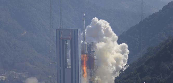
China continues to update the BeiDou navigation satellite system. On Feb. 12, two more navigation and positioning satellites were launched into medium Earth orbits, following the successful launch of a pair of BeiDou satellites on Jan. 11.
A Long March 3B rocket with a Yuanzheng-1 upper stage lifted off from the Xichang Satellite Launch Center, Sichuan Province, at 13:03 local time (05:03 UTC), according to gbtimes.com.
The launch had been set for the same window on Feb. 10, but was delayed by the visit of Chinese president Xi Jinping to the launch site.
Success of the mission was confirmed four hours after launch, following insertion of the satellites into their intended orbits, around 21,000 kilometers above the Earth.
The newly launched pair are BeiDou-3 28 and 29. The satellites are part of a third phase of Beidou deployment, which will take Beidou coverage from regional to covering the countries along the Belt and Road initiative by the end of 2018, and global by 2020.
According to Nasaspaceflight.com, the satellites are using a new bus featuring a phased array antenna for navigation signals and a laser retroreflector, with a launch mass of 1,014 kg.
The accuracy, stability and signal strength of the Beidou-3 satellites is improved over previous versions by developments in atomic clocks, laser communications and inter-satellite links.
The Long March 3B/YZ-1 carrying Beidou satellites 28 and 29 lifts off from Xichang Satellite Launch Centre at 13:03 local time on Feb. 12. (Photo: CNS)
Modules featuring Altair’s ALT1250 CAT-M1/NB1 chipset will be demonstrated at Mobile World Congress.
Altair Semiconductor, a provider of LTE chipsets, has selected Rohde & Schwarz as its partner for test equipment for its dual-mode CAT-M1/NB1 internet of things (IoT) ALT1250 chipset, as well as its next-generation IoT chipsets.
The ALT1250 is a highly integrated dual-mode CAT-M1/NB-IoT chipset with GNSS. Modules with ALT1250 inside are the world’s smallest, and may be as small as 100 millimeters square in area.
The ALT1250 includes GNSS location positioning, a wideband RF front-end supporting all commercial LTE bands within a single hardware design, a multi-layered and hardware-based security framework, an internal application subsystem and packaging that enables standard, low-cost PCB manufacturing.
The Rohde & Schwarz R&S CMW500 test platform offers the most validated CAT-M1/NB-IoT protocol conformance tests. It allows manufacturers and test houses to use a single instrument to verify that chipsets, modules and devices comply with GCF and PTCRB standards, and specific network operator requirements.
The test equipment will be used for protocol testing as well as RF, RRM performance and carrier tests.
Rohde & Schwarz is a global manufacturer of wireless communications and EMC test and measurement equipment and plans to develop new testing protocols for Altair’s next generations of cellular IoT chipsets.
“Our ALT1250 chipset is already forming the foundation for multiple current and emerging IoT applications,” said Ilan Reingold, VP of business development and marketing for Altair. “The choice of Rohde & Schwarz is part of our commitment to the highest quality of advanced validation and performance testing for our game-changing products.”
“This announcement confirms the commitment of Rohde & Schwarz to the wireless industry to provide innovative test tools and solutions that allow the testing and certification of cellular IoT devices,” said Anton Messmer, vice president, mobile radio testers, for Rohde & Schwarz. “We are pleased to have been selected by Altair and are looking forward to supporting them in the development of highly integrated chipsets in conformance with 3GPP Release-13 standards for CAT-M1 and NB-IoT, and beyond.”
Altair will be demonstrating partner modules based on ALT1250 at Mobile World Congress (MWC) in Barcelona, Spain, Feb. 26 to March 1 at Altair meeting rooms in Hall 2, Stands 2B2Ex and 2B4Ex.
Rohde & Schwarz will showcase CAT-M1/NB-IoT test solutions with the R&S CMW500 at MWC in hall 6, booth 6C40.
The U.S. Air Force plans to release a request for proposal (RFP) for the second phase of GPS III Follow-On satellite production “on or about” Feb. 13, according to a report by Inside Defense.
The RFP was expected in December 2017, but was held up as officials worked to solidify requirements.
The solicitation is expected to result in a contract for up to 22 GPS III Follow-On satellites in the 2019 time frame.
Lockheed Martin is on contract to build the initial 10 GPS III satellites, the first of which is expected to launch this year. Besides Lockheed, Boeing and Northrop Grumman have both expressed interest in competing to produce the next batch of satellites.
By Oliver Leisten Technical Director, Helix Technologies Ltd.
To attain the 10-centimeter accuracy required for autonomous vehicle positioning within urban multipath propagation conditions, there is a need for a significant upgrade in GNSS antenna performance. The autonomous vehicle application demands excellent antenna performance together with exploitation of the full set of GNSS multi-frequency and multi-constellation system advances to deliver this performance paradigm in the most severe of real-world use scenarios.
Given that an antenna necessarily operates in open fields, it follows that field resonance must be managed to provide predicable performance in diverse use-scenarios. A new antenna developed by Helix Technologies (Figure 1) deploys balanced fields across a cylindrical ceramic dielectric core to constrain the outreach of resonance fields and thereby minimize the interaction with nearby objects. The antenna feed is designed to provide enforcement of balanced operation, which ensures that the antenna resonates predictably and independently of the platform (i.e., the vehicle in the case of autonomous driving). Thus, the operation is not significantly influenced by the mechanical or material properties of the platform or housing. This architecture provides isolation from common-mode signals and protects the GNSS signals from conducted interference.
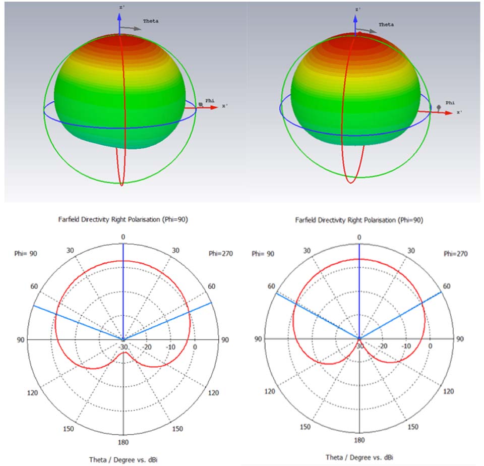
Figure 1. Features of the hexafilar-turnstile solution for multi-frequency GNSS.
It is challenging to configure a GNSS antenna operating at many frequencies in which the performance at any one frequency is not impaired by mode interactions. Such impairments can have serious consequences for the position accuracy in an urban environment because they adversely affect the cross-polar discrimination: a parameter which is most important for eliminating multipath positioning errors. The architecture of the hexafilar-turnstile antenna has overcome this problem and delivers the circular polarization pattern characteristics illustrated (simulated data) in Figure 2.
Figure 2. Simulated RH circular polarized patterns at GPS L1 (left) and GPS L2 (right).
The figure demonstrates that the antenna is forming cardioid patterns at two frequencies. The 3D graphic is intended to show the omni-directionality and the 2D elevation cuts exhibit the signature cardioid shape which characterize a “spinning-dipole” circular polarization antenna.
It is often suggested that patterns of wide beam-width such as these would not be particularly suitable for positioning in urban canyons where the sky can only be seen in a relatively small solid angle. In fact, the ratio of front-to-back gain is strongly associated with the cross-polar discrimination that is important for position accuracy in urban environments. Patterns of this quality can deliver as much as 30-dB of signal-to-interference advantage in favor of the direct-path satellite signals against signals whose polarization has reversed due to multipath reflection.
Helix Technologies is developing antennas which have two-pole frequency responses that provide two frequencies of optimum cross-polar discrimination that are aligned to the two frequencies of maximum spectral density of an M-BOC or Alt-BOC coded signal, as transmitted by the modern GPS and Galileo satellites respectively. These antennas should be available for test and evaluation in Q2 of 2018.
Rolls Royce is investing in autonomous shipping systems.
We no longer live in the Nuclear Age. Did you notice? Use of the term faded away. We no longer define our lives by the existence of nuclear technology, though of course it’s still part our world.
While the naming of “ages” is arbitrary, most people would say we’re currently in the Information Age. The last Great Age before the Information Age was the Industrial Age. We also experienced smaller “ages” such as the Space Age and the Atomic or Nuclear Age, but these didn’t impact our daily lives like the Industrial Age and Information Age have.
Which led me to wonder, what’s next? There’s a good chance we will find ourselves in the Autonomous Age, a daily experience of interacting with machines, robots and drones accomplishing tasks formerly done by people — including ourselves. We already use industrial robots; this trend will continue into new, more personal areas.
Inside our Smart Cities, we’ll wake up in a talking house built by autonomous construction machines, eat breakfast food that arrived via autonomous shipping and then delivered by drones, and travel to work via autonomous vehicles.
Artificial intelligence, augmented reality and autonomous vehicles will be woven into the tapestry of our daily lives. Overarching infrastructures and architectures will coordinate all the diverse autonomous and intelligent devices that we use.
“Artificial intelligence is sweeping across industries, and its next frontier is autonomous intelligent machines,” NVIDIA founder and CEO Jensen Huang said, speaking at GTC Japan in December. “Future machines will perceive their surroundings and be continuously alert, helping operators work more efficiently and safely.”
SuperSurv’s NTRIP solution is being enhanced to adopt more RTCM versions and provide a better GNSS positioning service. NTRIP (Networked Transport of RTCM via internet protocol) is a protocol to send GNSS-related data through the internet, which enables users of differential GPS or network real-time kinematic (RTK) to get correction parameters after connecting to the internet. The correction parameters can be used to calculate a more accurate GNSS location. Supergeo’s product team is developing the support for RTCM 3.1, including Types 1021 and 1023.
The scalable A222 GNSS smart antenna is designed for both agriculture and basic indicate systems markets, as well as other markets requiring flexible positioning. The smart antenna has the flexibility to scale and grow as business expands and can be configured from L1-only to multi-GNSS, multi-frequency and real-time kinematic (RTK). It adds a system component so that tractor and farm equipment manufacturers can deliver their own guidance and control solutions to their customers. Designed to excel in challenging environments, the A222 uses Hemisphere’s Athena RTK engine and is Atlas L-band capable. It is easy to mount and customizable. Its dual-serial, CAN and pulse output options are compatible with almost any industry-standard interface. Because the A222 is Atlas-capable, it has the ability to use the new Atlas AutoSeed technology. Atlas AutoSeed allows users to suspend Atlas use for any period, and upon returning to their last location, AutoSeed rapidly re-converges to a high-accuracy converged position. A222 comes pre-configured with Atlas Basic activated.
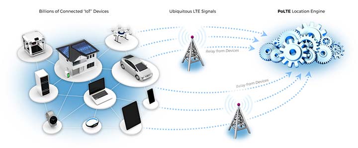
Locates mobile devices moving indoors and outdoors
Leveraging ubiquitous LTE signals, the Lite-Touch Architecture calculates positioning in the cloud to efficiently locate devices between indoor and outdoor environments. By offloading computation-heavy location calculations from the device to the cloud, the PoLTE positioning solution makes location positioning available to a wider variety of devices, including those constrained by battery life, memory, processing power, size and cost. This includes IoT-based applications that historically relied on GPS, with its high rate of power consumption, as well as Wi-Fi and Bluetooth with their added size, cost and network complexity.
Enhancements to the SyncServer S600 series of time servers and instruments improve time synchronization over enterprise Ethernet networks and supply timing signals for improved military radar operations and satellite uplink communications. The SyncServer S600 series also meets the timing and synchronization needs of the rapidly evolving networks of enterprise and financial customers, particularly for compliance purposes such as the European MiFID II directive, which specifies highly stringent time accuracy requirements for stock trading systems. The latest release includes support for the IEEE 1588 multiport, multi-profile Precision Time Protocol (PTP), which allows the S600 to operate as an independent grandmaster clock on each Ethernet port — delivering cost savings and network deployment flexibility to customers. This is coupled with a new 10-GbE interface to easily interoperate with a wider variety of network and stock trading topologies.
The HG4930 inertial measurement unit (IMU) is tailored for “straight-out-of-the-factory” integration and use in various non-defense and non-aerospace industrial applications including surveying and mapping, autonomous vehicles and gimbal stabilization. The HG4930 IMU is not classified under an International Traffic in Arms Regulation category; it is free from the burden of an export license for all but a few military-related use cases. The micro-electro-mechanical system (MEMS)-based IMU has been tailored to provide significantly improved gyroscope and accelerometer performance for the environments and use cases experienced by non-aerospace and non-defense users.
The HX-DU2017D is a frequency-hopping OEM modem designed to provide strong anti-jamming and signal receiving capability for complex data-intensive applications. HX-DU2017D is a miniature, dual-frequency, software-selectable 840-MHz and 900-MHz data link modem. It provides power switching of 0.5 W, 1 W and 2 W; 20 ms/30 ms/40 ms/50 ms/ frequency-hopping intervals; and supports point-to-point, point-to-multipoint network. Its full duplex mode ensures secure data transferring and stable long-range communication. The HX-DU2017D also provides short latency of data transmission and communication recovery in millisecond level. It allows fast and secure simultaneous data communication for mission-critical applications, especially in the fields of precision agriculture and UAVs, including unmanned plant surveys, UAV plant protection and automatic mowers. It could be placed on a UAV with its extremely small footprint for tight OEM integration and design flexibility. Meanwhile, its frequency-hopping transmission ensures UAV data security and flight stability.
For small construction, thermal inspections and public safety
The Parrot Bebop-Pro Thermal is a compact quadcopter with two embedded cameras: a stabilized 14-megapixel high-definition front-facing video camera and a FLIR ONE Pro thermal camera. The thermal-imaging camera is positioned in a dedicated module at the back of the drone. Three thermal-imaging setting modes are available: Standard, Dynamic and Hotspot. The Parrot FreeFlight Thermal app innovatively transmits and analyzes images captured by the quadcopter’s cameras. Included is a long-range Parrot Skycontroller 2 remote control.
Pergam gas sensor integrated with carbon-fiber UAV
Pergam gas sensor aboard the Microdrones md4-1000 UAV.
The aerial methane detector mdTector1000 CH4 detects methane gas via a fully integrated aerial package. It has a Pergam gas sensor, mounted and integrated with the Microdrones md4-1000 UAV. In real time users can see aerial shots of detection with the laser sensor. The carbon-fiber-built UAV goes into dangerous areas unsuitable for workers. The mdTector1000 CH4 can be used for natural gas line surveys, tank inspections, gas well testing, plant safety and landfill emission monitoring. The mdCockpit Android app allows users to maintain visualization in flight. A special mdTector app allows users to visualize and present all post-flight data on one map.
Microdrones, www.microdrones.com
UAV tracking antenna
Portable antenna for unmanned or manned aircraft
The Octopus UAV portable tracking antenna enables long-range data transmission and is suitable for unmanned and manned aircraft applications. It has a range of more than 100 kilometers and an integrated pointing algorithm. The GPS location of the aircraft is sent over the Airlink IP datalink and received directly by the tracking antenna, making it operational with any existing unmanned aircraft autopilot system. For a manned aircraft, an existing GPS receiver or dedicated GPS receiver can be used.
Brings high-precision positioning and attitude to small UAVs
AsteRx-m2 UAS receiver.
The AsteRx-m2a UAS GNSS OEM engines provides precise and reliable multi-frequency, all-in-view real-time kinematic (RTK) positioning and heading — along with interference technology — with low power consumption. It features Septentrio’s AIM+ interference mitigation and monitoring system, which can suppress a wide variety of interferers. It is designed to bring high-precision positioning and attitude to any space-constrained application, offering a high update rate and low latency output. The AsteRx-m2a UAS provides plug-and-play compatibility for autopilot systems such as ArduPilot and Pixhawk. Event markers accurately synchronize camera shutter events with GNSS time. The board can be powered directly from the vehicle power bus via its wide-range input. It works seamlessly with GeoTagZ software, providing offline re-processed RTK accuracy without the need for either ground control points or a real-time datalink.
The GPS-TMG-HR timing antennas are designed for Positive Train Control and railroad management, among other markets. They are equipped with high-rejection narrowband filtering to mitigate interference and provide 65-dB rejection of frequencies adjacent to L1 GPS. The GPS-TMG-HR maintains all features of PCTEL’s GPS timing reference platform. The antennas feature a 26-dB amplifier (GPS-TMG-HR-26N) and 40-dB amplifier (GPS-TMG-HR-40N ) and narrowband high rejection filtering to support long-lasting, trouble-free deployments in congested cell-site applications with severe interference around the GPS L1 frequency. The proprietary quadrifilar helix design, coupled with multi-stage filtering, provides superior out-of-band rejection and lower elevation pattern performance than traditional patch antennas.
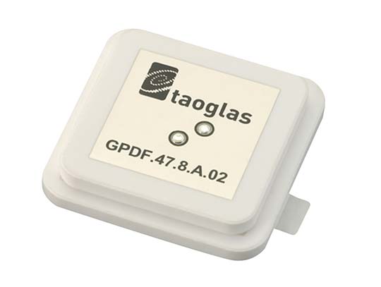
The GPDF.47.8.A.02 is a ceramic GPS L1/L2 / Galileo low-profile, low-axial ratio, embedded stacked passive patch antenna. It is 47.5 x 47.5 millimeters wide and 8 millimeters thick. It is designed for the highest accuracy centimeter-level tracking in telematics applications for positioning technologies. Typical applicable industries are transportation, defense, marine, agriculture and navigation.
The Autonomy Development Platform provides automakers, truck makers and Tier 1 vehicle suppliers the hardware, software, engineering and integration services they need to accelerate development programs for on-road and off-road autonomous vehicles. By combining customized integration and engineering services with GNSS-inertial positioning technologies, the Autonomy Development Platform advances driverless vehicle development projects at every stage of development and commercialization. The platform delivers a navigation solution that is fully customizable and includes integration and engineering services, field-tested hardware and proprietary software for highly accurate positioning. The solution is capable of working with all sensors, including multiple cameras, lidar, radar and ultrasonic sensors, and with all vehicle types at all stages in the development and commercialization cycle. Also, the technology enables highly accurate assessments of the full 360-degree environment around a vehicle to produce a robust representation, including static and dynamic objects, which is critical for successful vehicle autonomy.
TomTom AutoStream is a map delivery service for autonomous driving and advanced driver assistance systems. The service enables vehicles to build a horizon for the road ahead by streaming the latest map data from the TomTom cloud. TomTom AutoStream ensures that the TomTom map data used to power advanced driving functions is the latest, most accurate available, enabling a safer and more comfortable experience. The map-data stream can be customized based on criteria such as sensor configuration and horizon length. It can stream a wide variety of map data including advanced driver assistance systems (ADAS), attributes such as gradient and curvature, and the TomTom HD Map with RoadDNA. This flexibility allows customers to use AutoStream to power a wide range of driving automation functions.
A new company, hoopo, has launched to supply an innovative, accurate geolocation solution for low-power wide area (LPWA) networks. The solution would improve precision for low-power Internet of Things (IoT) asset tracking.
Hoopo’s geolocation enables companies to locate their valuable assets without the significant cost or battery consumption that can be associated with GPS. hoopo’s IoT solutions help companies precisely track specific assets in areas such as shipping ports, airports, car dealer lots, cattle ranches and other asset-dense areas.
Hoopo has received $1.5 million in funding to further grow its business from a group of investors, including the initial investors in Mobileye; Israeli investor Zohar Gilon; and Ben Marcus, CEO of AirMap.
The need to understand and quantify asset location is quickly becoming a requirement for the enterprise and industrial IoT. However, the accuracy of today’s low-power geolocation isn’t precise enough to deliver on the full promise of the IoT.
LPWA networks are becoming the driving force behind smart city and other IoT applications because of their low-cost, low-power consumption, and high-coverage capabilities in rural and urban environments. The long battery life of LPWA devices allows businesses to deploy a maintenance-free device in the field for several years.
“Hoopo is addressing a real business need of companies around the world: cost-effective, yet precise, tracking of their valuable assets with longevity of battery life up to 10 years in the field,” said Ittay Hayut, CEO of hoopo. “LPWA checks off all of the boxes companies need in terms of cost and coverage, and hoopo’s solutions work alongside these LPWA networks to help businesses keep their assets safe, anytime and anywhere.”
Hoopo’s solutions are based on a patent-pending triangulation method that uses LPWA data transmissions to generate a precise location. The solutions suite includes low-cost LPWA gateways and devices, as well as a platform for management and real-time notifications. Companies can receive on-demand geolocation, establish geofences, receive movement alerts, and more, ensuring the protection of their valuable assets.
“Hoopo’s geolocation technology reveals new business verticals that were limited or impossible when using existing technologies because of their high-cost and significant power consumption,” said Menashe Terem, CEO at Tri-logical, a provider of tracking and management solutions.
“Early applications such as asset tracking are just the beginning of what advances in geolocation will enable,” said Eli Fogel, former CTO at Intel and hoopo investor. “Just as the advent of GPS launched a wealth of applications that no one ever thought of before, such as location-based advertising, there are future applications that this next generation of geolocation technology will enable. We’re excited to see what new applications emerge as customers embrace these new precision location capabilities.”
Hoopo is displaying at Mobile World Congress in Barcelona Feb. 26-March 1 in Hall 5, Stand 5D81.
 TerraGo is now offering GXP InForm, a new add-on module for BAE Systems’ GXP Xplorer platform.