Collaboration includes support from Space Florida and Israel Innovation Authority
MySky ECO, a U.S.-based leader in efficient aviation, and Airwayz, a global leader in Unmanned Traffic Management (UTM) technology, have launched a joint venture to develop a next-generation long-range UAV system.
The project was selected for funding by the Space Florida–Israel Innovation Partnership Program and is designed to demonstrate a fully autonomous drone platform capable of Beyond Visual Line of Sight (BVLOS) operations in regulated and complex airspaces across the United States.
The companies share a common mission to prove that unmanned aircraft can operate safely and efficiently alongside traditional aviation in real-world, high-traffic environments.
The system will integrate MySky’s MS-1D UAV platform, derived from its eco-efficient light aircraft technology, with Airwayz’ AI-based UTM software. The Airwayz platform enables real-time coordination of multiple drone fleets, dynamic airspace management, and safe coexistence with manned aircraft, enabled with strategic and tactical deconfliction capabilities.
Development is already underway, with flight testing targeted at the end of the year. The system will be evaluated across multiple high-impact use cases — including medical and organ transport, emergency and package delivery, search and rescue, and border reconnaissance — requiring a long-range, high-speed drone capable of operating from short or unimproved runway environments.
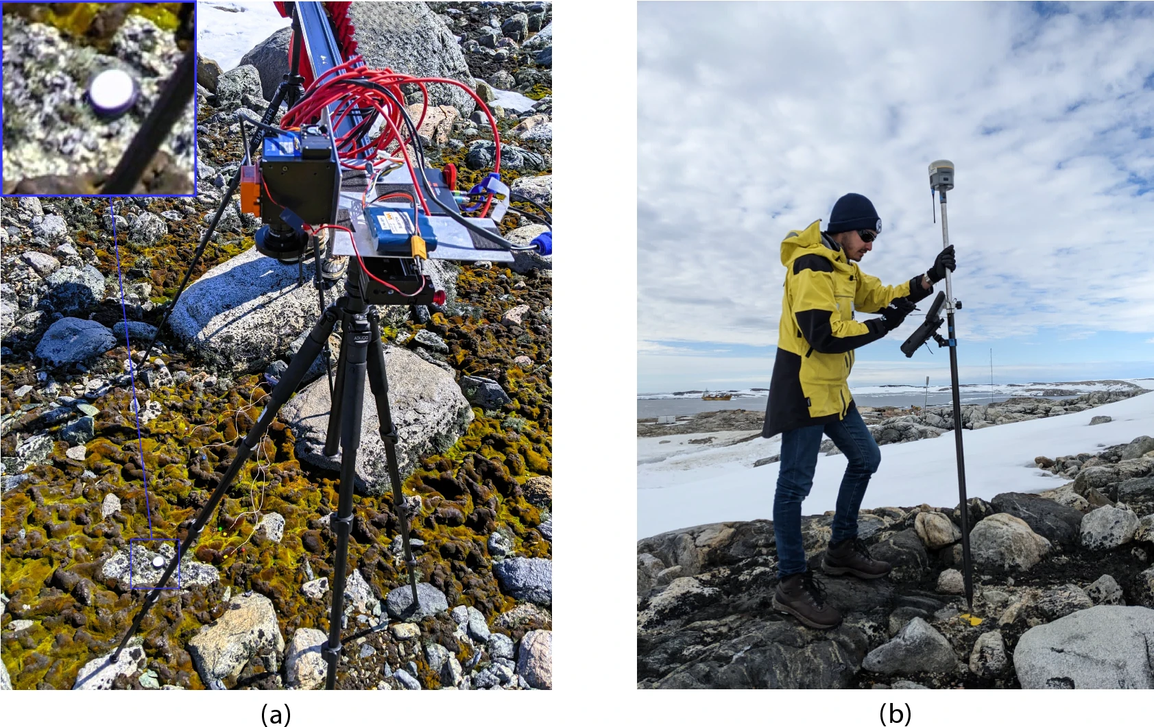
GNSS and unmanned aerial vehicles (UAVs) have revolutionized precise mapping in polar regions. For a team from Queensland University of Technology (QUT), UAVs enabled a flexible platform for deploying hyperspectral imaging (HSI) sensors and collecting high-resolution data, enhanced by GNSS with real-time kinematic (RTK) to ensure accurate geolocation for reliable vegetation analysis.
The team turned to UAVs to meet the unique challenges of monitoring Antarctic vegetation. Harsh conditions, remoteness, limited access and climate variability make traditional field surveys time-consuming and costly. Worse, they risk disturbing sensitive vegetation, explain the researchers.
What Grows There. Antarctica’s terrestrial ecosystems are home to freeze-tolerant vegetation like mosses and lichens, which play a crucial role in biogeochemical cycles, soil insulation and supporting biodiversity. These organisms underpin the continent’s fragile ecosystems, increasingly threatened by climate change, extreme events, and human activitiees.
While satellite imagery enables large-scale observations, its limited spectral and spatial resolution, alongside cloud interference, constrains fine-scale vegetation analysis. HSI captures a broad wavelength range, enabling discrimination of vegetation by their spectral signatures. Multispectral imaging (MSI) data, such as that from Sentinel-2, is also being explored.
UAVs offer flexible spatial coverage and high-resolution datasets.
However, unless these elements are integrated, mapping accuracy diminishes. Moreover, limited validation of spectral libraries and simulated imagery against field data restricts the reliability of remote sensing outcomes.
The team’s study addresses current gaps by building on the UAV-based HSI workflow that incorporates ground-based HSI data and MSI. “We expand this approach by integrating UAV-captured HSI data to enhance remote sensing capabilities in polar environments,” researchers explain. The updated methodology combines UAVs, high-resolution red, green, blue (RGB) imagery, and ground and aerial HSI data with machine-learning-based semantic segmentation.
The new workflow was evaluated in Antarctic specially protected area (ASPA) 135, Windmill Islands, East Antarctica, focusing on lichen detection and moss health mapping (Fig. 1).
Location of ASPA 135 (6616’60” S, 11032’60” E) and studied vegetation. (a) Map of Antarctica showing Casey Station’s location using the Polar Stereographic Projection. (b) Map delineating ASPA 135 (purple) near Casey Station (top left). (c) Ground-level imagery of moss and lichen at ASPA 135, along with surrounding rock and ice formations. (Credit: QUT)
Read the full study, “Drone hyperspectral imaging and artificial intelligence for monitoring moss and lichen in Antarctica,” on the Scientific Reports website.
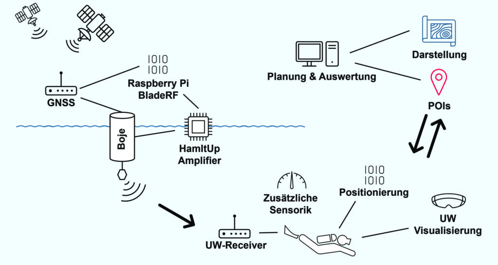
Buoys located via GNSS and electromagnetic signals enable divers to navigate underwater in a way that is gentle on the animals. A head-up display in the mask shows the appropriate routes.
A team led by Philipp Berglez from the Institute of Geodesy at Graz University of Technology, Styria, Austria, has developed a navigation system for divers that uses GNSS-supported buoys. The buoys emit electromagnetic signals to enable animal-friendly, precise positioning underwater.
Using a heads-up display in their mask, divers can find their way to their desired destinations, back to the dive boat, or around restricted areas. The divers also can always be found in an emergency.
Wave propagation the biggest challenge
The navigation system’s operating principle combines the precision of satellite navigation with the transmission of electromagnetic signals underwater. The buoys are placed in the operational area and determine their position via GNSS, more specifically via the Galileo High Accuracy Service (HAS).
A signal generator in the buoys sends electromagnetic signals to the divers, who carry a receiver the size of a cookie. Since several buoys communicate simultaneously with the divers’ receivers, the various distance information can be used to determine their position and depth using trilateration.
TU Graz and partners have developed a GNSS navigation system for divers. (Credit: TU Graz, Institute of Geodesy)
Ocean environment. “The biggest challenge for us was calculating the propagation of the electromagnetic signals underwater to obtain the appropriate distance values,” Berglez said. “The properties of the water — such as salinity, temperature, depth or conductivity — have a major influence here. Due to these diverse and variable influencing factors, modeling the propagation properties underwater was particularly challenging.”
The research team succeeded in transmitting signals horizontally over 150 meters, but the scientists still see considerable potential for optimization when it comes to penetrating greater depths of up to 100 meters.
Applications. The underwater navigation system is useful for divers in several applications. In the tourism sector, it is ideal for sport and recreational diving, where dive sites equipped with position buoys help visitors find underwater sights. They can see the route there on the mask’s head-up display. The company Oxygen Scientific has already developed a head-up display mounted on the mask.
The system is also useful in the fields of aquatic ecology, underwater archaeology and underwater debris documentation.
Wildlife Friendly. It was important to the project team that the system, unlike sonar, would not impact wildlife. Test measurements were conducted with golden rainbow trout, which are normally very sensitive to external influences.
During measurements with different transmission power levels, the fish showed no abnormal behavior, and they continued to behave normally even after the measurements were completed. The golden trout were equally unaffected one week, one month and four months after the measurements, ruling out any delayed negative effects with a very high degree of probability.
In addition to TU Graz, project partners included pentamap GmbH, 1st-Relief GmbH, Oxygen Scientific GmbH, Disaster Competence Network Austria , and the Austrian Center for Research Diving.
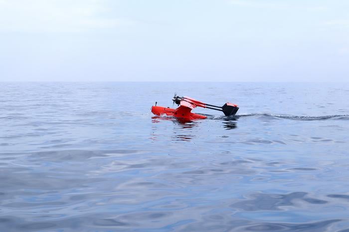
Researchers demonstrate a seaplane-type UAV using GNSS-A can precisely measure seafloor deformation
Megathrust earthquakes are large earthquakes that occur on faults found along the boundaries between tectonic plates. The Nankai Trough is a megathrust earthquake zone lying off the southwestern coast of Japan, and experts estimate that this zone could generate a potentially devastating (magnitude 8 or 9) large earthquake sometime in the next 30 years. A seismic event of this magnitude could trigger cascading hazards such as destructive tsunamis.
Developing the technologies for efficient and reliable seafloor monitoring is paramount when considering the potential for socioeconomic harm represented by megathrust earthquakes. Traditionally, seafloor measurements have been obtained using transponder stations on the seafloor that communicate with satellites via buoys or ocean-going vessels to produce accurate positional information. However, data collection using such systems has problems such as low efficiency and speed.
In a study published in Earth and Space Science, researchers at Institute of Industrial Science, the University of Tokyo, addressed the challenge of acquiring reliable, high-precision, real-time seafloor measurements by constructing a seaplane-type unmanned aerial vehicle (UAV) that can withstand ocean currents and wind. This vehicle is intended for use with the GNSS–Acoustic (GNSS-A) ― a system that uses satellites to determine locations on Earth ― to provide a communication link with seafloor transponder stations.
“We conducted initial experiments in a water tank,” explains lead author of the study Yuto Yoshizumi, “and found that the proposed system can detect distances to an accuracy within 2.1 cm.”
To further evaluate the system, at-sea trial tests were performed by landing the UAV on the sea surface off the coast of Japan under optimal sea conditions. “The results were hugely encouraging,” said senior author Yusuke Yokota. “These seafloor positioning measurements are the first ever achieved using a UAV, and we attained a horizontal root mean square error of approximately 1–2 cm, which is easily comparable to that of existing vessel-based systems.”
The rapid real-time acquisition of seafloor information using the UAV system developed by the research team at Institute of Industrial Science, the University of Tokyo, is expected to provide the foundation for advanced research into earthquake disaster prevention. Such data are urgently needed given the speed and frequency of occurrence of megathrust earthquakes on the Nankai Trough.
NAL Research is partnering with SGM Technology, a maritime technology company, and Tschudi Shipping, a maritime logistics company, to deliver a resilient navigation and tracking product line for the commercial shipping industry enabled by Iridium’s low-Earth orbit (LEO) satellite network.
NAL Research is a U.S.-based firm specializing in assured positioning, navigation and timing (APNT) solutions.
The partnership aims to provide reliable asset tracking and assured navigation in high-risk maritime environments. Threats to GPS and GNSS signals — such as jamming, spoofing and interference — are reaching unprecedented levels worldwide. In some regions, maritime authorities reported a 350% increase in affected vessels over the past six months, according to NorthStandard. These disruptions are leading to serious consequences, including collisions, delays, financial impacts on global trade, and heightened security risks for crews at sea.
Under the partnership agreement, the companies are leveraging NAL Research’s 25+ years of expertise in APNT, tracking, and connectivity to develop solutions built on the Iridium PNT service, a powerful and fully authenticated L-band signal resilient to spoofing and jamming.
The partnership will also benefit from SGM’s 15+ years of experience delivering technology to the commercial maritime sector and Tschudi Shipping Company’s global presence and 140+ years in commercial shipping and logistics. Together, the collaboration aims to provide maritime users with unmatched resilience and reliable navigation for GPS/GNSS-compromised environments. Trials of this state-of-the-art solution are underway.
Honeywell has been selected by the U.S. Department of Defense’s (DOD) Defense Innovation Unit (DIU) to participate in the Transition of Quantum Sensing (TQS) program. The program aims to accelerate adoption of quantum sensors to address near-term alternative position, navigation and timing (PNT) and intelligence, surveillance and reconnaissance (ISR) applications for the U.S. Joint Forces Command.
Honeywell has been chosen to support the TQS program under two DOD contracts: CRUISE (Compact Rubidium Unit for Inertial Sensing and Estimation) and QUEST (Quantum Enabled Sensor Technologies for MagNav).
“With the growing threat of jamming and spoofing, aircraft and naval vessels on critical missions can no longer rely solely on GPS,” said Matt Picchetti, vice president and general manager, Navigation and Sensors, Honeywell Aerospace Technologies. “Quantum sensors have the potential to augment existing navigation solutions, helping pilots operate with greater confidence. Honeywell’s pedigree in fielded sensors and navigation solutions provide us with a unique perspective to ensure the technology is viable beyond the laboratory.”
The CRUISE program, established by the DOD in partnership with Vector Atomic, will focus on developing quantum sensor-based inertial measurement units (IMUs) to provide a standalone navigation solution without relying on traditional GNSS susceptible to jamming and spoofing. Honeywell will support the development of this quantum-sensor-based technology, which will enable the measurement of acceleration and orientation from an IMU mounted to a vehicle to calculate changes in position and velocity. As a result, it will meet next-generation performance requirements at a lower size, weight and power than existing products.
The QUEST program aims to advance the performance of magnetic anomaly aided navigation (MagNav), which is a GNSS-independent navigation technique that uses quantum magnetometers to leverage measurements of the magnetic field of the Earth as a navigation signal. Through the program, the DOD aims to improve these quantum magnetometers and demonstrate their utility in GNSS-denied flight. Building on its deep expertise in innovative navigation solutions, Honeywell’s main contribution will be to generate novel algorithms that utilize these sensors and improve navigation accuracy.
“As quantum sensor-based navigation technology matures, we believe it not only has the potential to displace existing technologies but will also be a serious disruptor to the inertial and magnetic sensor industries,” Picchetti said. “Most importantly, it could improve navigation in high-stakes environments – enhancing safety, efficiency and overall mission success for the DOD.”
Topcon Agriculture has released its new Value Line Steering solution for farmers using mid-range tractors on small- to medium-sized farms. The new offering represents a significant step in making autosteering technology, typically used on larger machinery, accessible to a broader range of farmers.
“With the Value Line, we are opening up opportunities for farmers who have older or smaller machinery, or smaller specialty farms, to boost the value of their machinery, with autosteering technology that is based on our proven premium steering technology used for decades on larger machines,” said Antonio Marzia, executive vice president, Topcon Agriculture. “It is an integrated system designed to seamlessly work with a variety of tractors, including compliance with ISOBUS-UT functionality to offer universal compatibility and ease of use. Our goal is to provide high-quality, reliable, affordable, value-added technology that works across a wide range of applications, machinery and brands.”
The Value Line Steering solution is a comprehensive package that includes a GNSS receiver, electric steering wheel controller, touchscreen console and Horizon Lite software, compatible with front-wheel-steer tractors. Farmers also have the option to add local, satellite or RTK correction services such as Topcon’s Topnet Live for enhanced precision based on their unique needs.
Autosteering allows for more efficient use of resources, leading to reduced input costs for seeds, fertilizers, and fuel. This not only improves the farm’s bottom line but also contributes to more sustainable farming practices. The increased accuracy in field operations can also lead to improved crop yields, further enhancing profitability.
Farmers from various agricultural sectors, including commodity crops, specialty crops, and mixed farming systems, can expect significant benefits in their operations when adopting the technology.
The Value Line Steering solution is available through Topcon Agriculture’s global network of authorized dealers.
SouthPAN includes Safety-of-Life L1 SBAS for civil aviation and open services for precise point positioning and next-generation SBAS.
The Southern Positioning Augmentation Network (SouthPAN) has successfully completed its Critical Design Review (CDR), marking a pivotal milestone towards delivering advanced satellite-based augmentation services (SBAS) across Australia and New Zealand.
Led by Lockheed Martin Australia, with GMV as a key strategic partner, SouthPAN is jointly supported by the Australian and New Zealand governments to provide satellite navigation and precise positioning services throughout Australasia.
The Critical Design Review represents a vital checkpoint in the lifecycle of a safety-critical system such as SouthPAN, validating that the design meets stringent performance, safety and security requirements necessary for civil aviation operations. As part of this milestone, the SouthPAN team provided comprehensive certification artifacts aligned with international aviation standards, including ARP 4754A for systems development processes, DO-254 for hardware, and DO-278A for software assurance.
The successful completion of the CDR demonstrates that the system’s architecture and implementation will satisfy the rigorous design assurance levels mandated for safety-of-life applications. Achieving this milestone confirms the readiness of the system’s design for operational deployment and marks a critical step forward towards its future certification for safety‑of-life services in the aviation sector.
SouthPAN is notable as the first SBAS globally designed from its inception as a service rather than as a conventional turnkey system. This service-oriented approach enables scalability and potential expansion into other regions, while establishing clear customer-provider interactions governed by service-level agreements (SLAs) and adherence to defined key performance indicators (KPIs).
Early open services have been provided since September 2022, demonstrating immediate benefits to users across Australasia. Moving forward, the SouthPAN service will fully deliver safety‑of-life L1 SBAS critical for aviation operations, significantly enhancing flight safety through precise runway approaches and superior navigation accuracy.
Additionally, SouthPAN has integrated cutting-edge dual-frequency multi-constellation (DFMC) SBAS and precise point positioning (PPP) through SBAS as open services available to diverse users, including the agriculture, maritime, rail, road transport and geomatics sectors. The DFMC SBAS capability is designed to support an effortless transition to future safety-of-life services through engineering updates and software modifications, without necessitating costly hardware replacements.
GMV is responsible for two core elements of the SouthPAN project: the Corrections Processing Facility (CPF) and the Ground Control Center (GCC). These facilities will ensure that SouthPAN consistently meets stringent performance benchmarks by generating precise corrections for navigation signals and promptly identifying and reporting anomalies critical for safety-of-life aviation services. GMV also leads the navigation performance engineering activities and continuous performance monitoring, ensuring the system reliably fulfills its specified operational criteria.
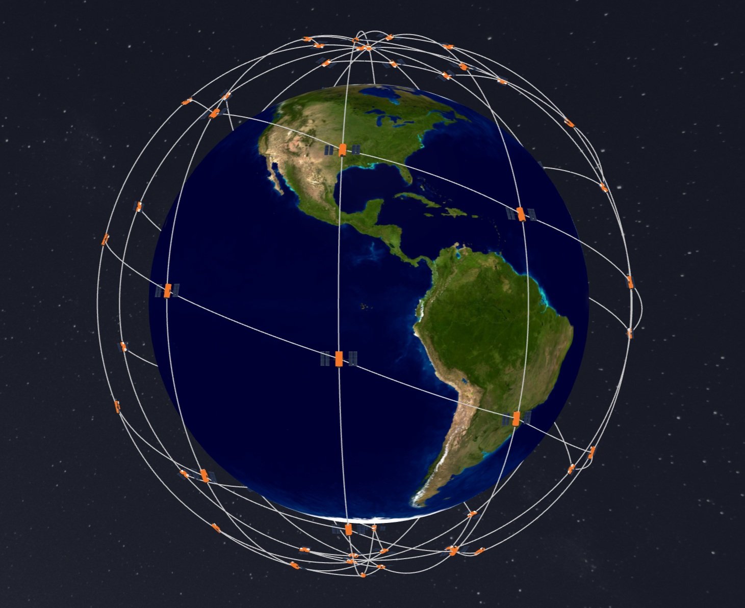
New multi-orbit space company has network of 120 GEO+MEO satellites and access to LEO constellations.
SES, a space solutions company, has completed its highly value accretive acquisition of Intelsat, creating a strengthened global satellite operator with an expanded fleet of 120 satellites across two orbits. The newly combined company will leverage its skilled teams with deep vertical expertise to deliver integrated multi-orbit, multi-band satellite and connectivity solutions to businesses and governments around the world, creating a stronger multi-orbit operator with ~60% of revenue in high-growth segments.
With a network of approximately 90 geostationary (GEO), nearly 30 medium earth orbit (MEO) satellites, strategic access to low-Earth-orbit (LEO) satellites, and an extensive ground network, SES can now deliver connectivity solutions utilizing complementary spectrum bands including C-, Ku-, Ka-, Military Ka-, X-band and Ultra High Frequency. The expanded capabilities of the combined company will enable it to deliver premium-quality services and tailored solutions to its customers. The company’s assets and networks, once fully integrated, will put SES in a strong competitive position to better serve the evolving needs of its customers including governments, aviation, maritime and media across the globe.
Adel Al-Saleh, CEO of SES, talks about the new combined company in the video below.
The transaction establishes a more robust financial foundation for SES, with pro formacombined revenue of €3.7 billion projected to grow at a low- to mid-single digit CAGR (2024-2028E). The combined company pro forma Adjusted EBITDA of €1.8 billion is expected to grow at mid-single digit CAGR including synergies (2024-2028E), with plans to generate over €1 billion in Adjusted Free Cash Flow by 2027-2028 (pre IRIS2). This stronger financial profile is supported by a combined contract backlog exceeding €8 billion, providing clear visibility into future revenue streams.
SES plans to maintain disciplined investment in future growth, with annual capital expenditures averaging €600–€650 million from 2025-2028E, excluding the IRIS2 programme. This will enable the company to continuously strengthen its network and explore emerging growthmarkets including Internet of Things (IoT), direct-to-device communications, inter-satellite data relay, space situational awareness, and quantum key distribution. The company’s profitable growth outlook, strong balance sheet metrics and expanded cash flows will support both continued innovation and increased shareholder returns, with the intent to raise the annual base dividend once targeted net leverage of below three times is achieved within 12-18 months after closing.
By integrating the two organizations, SES expects to deliver synergies with a total net present value of €2.4 billion, representing an annual run rate of approximately €370 million, with 70% of these efficiencies anticipated to be executed within three years after closing. These savings will primarily come from streamlined operations, optimised capacity costs, and procurement efficiencies, along with the strategic integration of satellite fleets and ground infrastructure.
SES remains headquartered in Luxembourg and is publicly listed on the Paris and Luxembourg stock exchanges (Ticker: SESG), while maintaining a significant presence in the United States with its North American main office in McLean, Virginia.
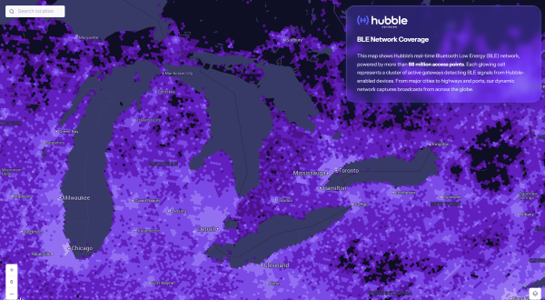
Bluetooth network enables real-time asset tracking for enterprises worldwide
The new Hubble BLE Finding Network is a Bluetooth Low Energy (BLE) finding network built specifically for enterprise use. Hubble, based in Seattle, is a satellite startup enabling Bluetooth devices to connect directly to space.
While consumer platforms like Apple’s Find My and Google’s Find My Device brought BLE discovery to personal devices, Hubble now brings that same reach and simplicity to businesses, offering real-time visibility and full data ownership on a global scale.
“Consumer networks proved what’s possible, but businesses were left out,” said Alex Haro, co-founder of Hubble. “We’re giving them a powerful alternative with global visibility, zero infrastructure and full ownership of their data.”
The Hubble BLE Finding Network leverages nearly 100 million passive scanners across gateways, smartphones and partner infrastructure, powered by low-cost BLE chips already embedded in billions of devices. This extensive network covers homes, cities, transit systems and industrial sites, enabling comprehensive global asset tracking for enterprises.
Key Features
Global Reach: Real-time bluetooth discovery via 88+ million scanners worldwide.
Data Ownership: Maintain full enterprise control with no closed systems or vendor lock-in.
Infrastructure-Free: Activate tracking with existing BLE devices, no hardware required.
Robust Security: Protect data with encryption, rotating IDs, and verified endpoints.
Developer Friendly: Enable seamless integration with open SDKs and APIs.
Enterprise Use Cases
Asset Tracking: Monitor tools, inventory, and equipment globally.
Fleet Management: Track assets in transit, on job sites, or in the field.
Temperature Monitoring: Instantly track temperature with BLE sensor tags.
Workplace Safety: Locate badges and wearables in hazardous environments.
Equipment Sharing: Gain visibility and usage insights across distributed teams.
The Hubble’s BLE Network is now live and available for commercial deployment, including developer tools and onboarding support. To learn more or apply for access, visithttps://hubblenetwork.com.
In March 2024, Hubble made history with its Bluetooth connection to space. With a 96-satellite constellation planned by 2028, the company aims to connect one billion devices worldwide.
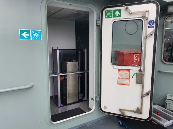
Q-CTRL has completed a major field trial with Australian Defence on board the Royal Australian Navy’s Multi-role Aviation Training Vessel (MATV), the MV Sycamore. The results of the trial demonstrated advancements in software-ruggedized quantum sensing for navigation.
In the trials, Q-CTRL field deployed a quantum dual gravimeter, which measures tiny variations in Earth’s gravity as part of a next-generation quantum-assured positioning, navigation, and timing (PNT) system operable when GPS is unavailable or untrusted.
This first trial saw over 144 hours of continuous operation and successful data collection with no human intervention during real maritime operations.
“Quantum sensors provide a near-term opportunity to achieve transformational defense capabilities, but previous deployments in the field have struggled to deliver defense-relevant performance,” said Q-CTRL CEO and founder Michael J. Biercuk. “Operating on a real moving vehicle is just not the same as conducting a science experiment; at Q-CTRL, we’ve taken a different approach to getting quantum sensors out of the lab, focusing on software as the critical enabler of performance in the real world.”
Earlier this year, Q-CTRL announced successful airborne field trials of a new generation of quantum-magnetic navigation solutions, Ironstone Opal, validated for the first time to outperform comparable conventional alternatives in challenging real-world settings by 50 times.
Developed and fielded in 14 months, the dual gravimeter was installed in a “strapdown” configuration (bolted to the floor) in the space of a single server rack in a communications room onboard MV Sycamore. The sensor consumed only 180W of power – about 10 times less than a household toaster.(Photo: Q-CTRL)
The newly announced trials of Q-CTRL’s gravimetric navigation technology open opportunities to bring quantum-assured navigation to maritime vessels where magnetic navigation can be less effective.
GPS denial has become one of the most pressing strategic challenges in both defense and commercial settings, risking major disruptions to civilian and military operations. Quantum navigation promises a robust and reliable GPS backup that cannot be jammed or spoofed.
Q-CTRL’s navigation capability is urgently needed in contested maritime environments, as instances of spoofed signals caused significant disruptions to ships in the Middle East waterways as recently as June 23. This causes not only critical logistical issues but disrupts collision avoidance efforts, revealing major safety implications.
In quantum gravimetric navigation, the quantum gravimeter continuously “sees” the otherwise invisible hills and valleys in Earth’s gravity, allowing a navigation computer to compare its observations against known gravity maps. This is similar to orienteering, where one can position oneself on a map by identifying landmarks like valleys, mountains, rivers, or roads. GPS is not needed, making it a robust backup in contested regions.
Q-CTRL’s demonstration with the Royal Australian Navy departs from most previous quantum sensing field trials in that these tests mandated peak performance with full autonomy and without the addition of any special infrastructure. The sensor had to operate as a real navigation system would operate during a defense mission.
The ship’s motion and engine vibrations were sufficient to cause total loss of signal using conventional operating techniques typically employed in research experiments. To address these losses, Q-CTRL’s software-ruggedization strategies recovered operation even while MV Sycamore was underway.
Quantum sensing leverages the physics of light and matter on the smallest scales to enable the detection of tiny signals. Because these devices work based on the fundamental laws of physics and are not affected by drift like other GPS alternatives, their outputs do not change over time, enabling new opportunities where long-term stability is essential. Generally, however, these devices are significantly degraded when taken from a research laboratory into the real world, an issue addressed by Q-CTRL’s software-ruggedization technology.
For more on Q-CTRL’s software-ruggedized quantum sensing technology, read their peer-reviewed technical demonstration published in Nature.
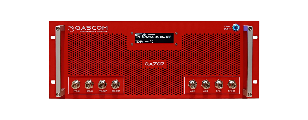
Qascom S.R.L. (IT) has successfully delivered the final presentation of the NAVISP-EL2-081 – MOOD (Moon testbed) project, marking the culmination of a multi-year effort to develop a cutting-edge GNSS simulation testbed for lunar, cislunar and space-based PNT applications.
For this purpose, Qascom upgraded its QA707 GNSS simulator introducing advanced features such as lunar-specific ranging strategies, support for multiple coordinate reference systems, custom signal transmitters (including LunaNet AFS), and a 3D Viewer for real-time scenario visualization. It also integrates BeiDou B1C signal simulation and dual-frequency RF streaming capabilities.
Key achievements include successful validation of LunaNet and BeiDou signals, implementation of Moon Principal Axis (Moon-PA) ranging, and integration with open-source and COTS receivers. The simulator has already supported the project NAVISP-EL1-062 – DEMOS-1(Lunar Surface PNT Beacon Demonstrator) and is now Qascom’s flagship GNSS simulation product.
The project was supported through NAVISP Element 2 for PNT competitiveness for European industry. The slides of this final presentation can be found here.