Author: Tracy Cozzens

  • UK, France partner to protect GNSS for critical infrastructure

    UK, France partner to protect GNSS for critical infrastructure

    United Kingdom and French experts will work more closely to increase the resilience of both countries’ critical infrastructure to the signal jamming experienced in the war in Ukraine. The agreements are part of a suite of joint science and tech work.  

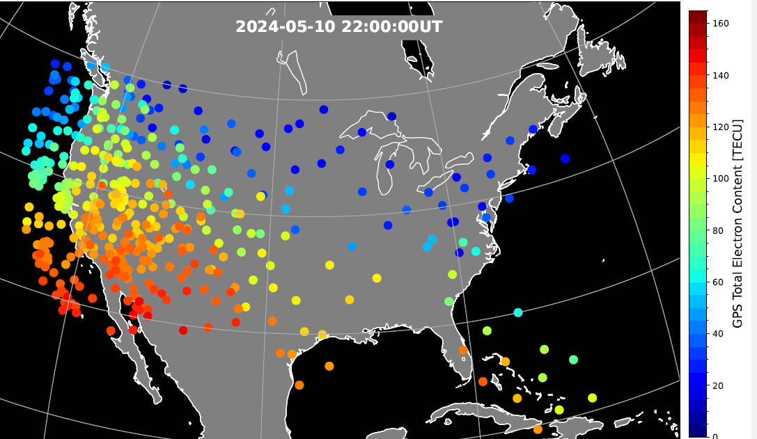
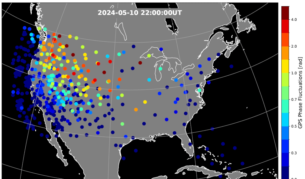
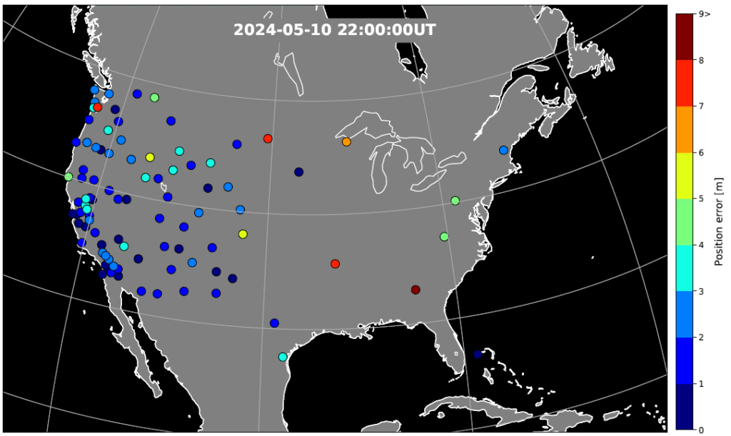
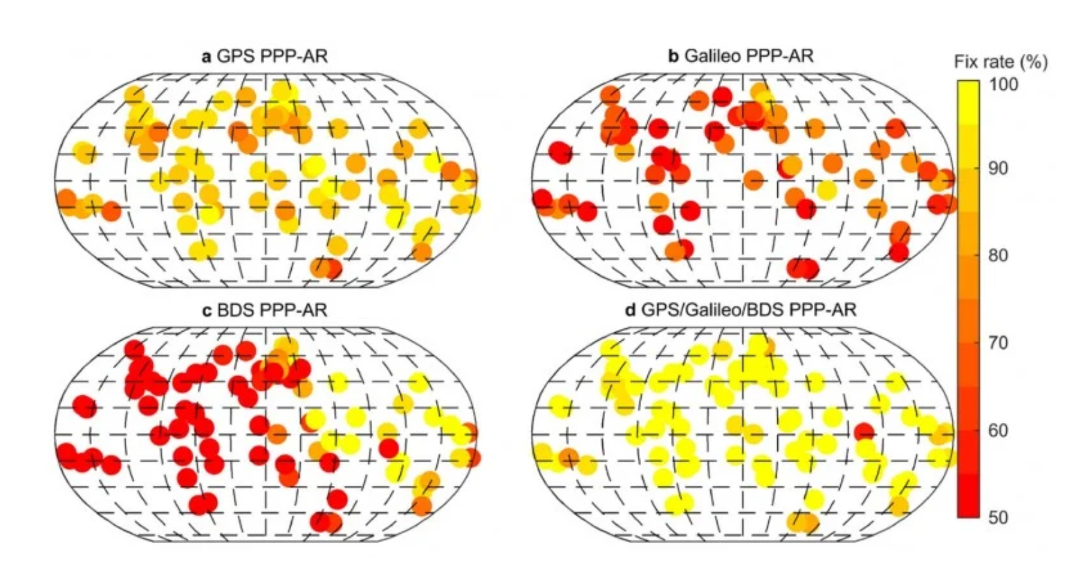
    The conflict in Ukraine has shown how new technologies — in some cases, small handheld devices — can be used to disrupt positioning, navigation and timing (PNT) services, potentially causing major disruption.

    As part of a raft of UK-France joint science and tech efforts announced July 10, researchers from both countries will work together on technologies that complement GPS, which are highly resistant to this sort of jamming.  

    For instance, the e-LORAN program, driven by the UK government, is working closely with the National Physical Laboratory and private sector companies. The system uses ground-based radio towers, which are much more challenging to block, for a reliable “backup” to GPS, so that UK infrastructure can keep running even when GPS fails.  

    The UK’s Science and Tech Secretary Peter Kyle used a joint visit to Imperial College London, with French President Emmanuel Macron, to set out how such a collaboration makes both the UK and France stronger and safer. While speaking at Imperial, Kyle pointed out the tens of millions of pounds in investment being brought into the British tech sector through UK-French trade, as well as the new jobs and growth that this partnership creates.

    These efforts will bolster the economic and national security of both countries, according to Kyle, which are foundational pillars of the Plan for Change.

    The UK and France also are launching a partnership on supercomputing. The partnership will be led by the Bristol Centre for Supercomputing, the home of Isambard-AI, and the French computing centre GENCI, who lead France’s AI Factory.  

    Closer ties between both nations’ compute power and sharing AI best practice will turbocharge the breakthroughs in AI, transforming public services and improving lives, Kyle said. These efforts build on the AI Opportunities Action Plan, the UK government’s blueprint to fuel the use of AI across the economy. It builds on the strong existing UK-France cooperation on AI. The UK’s AI Security Institute and France’s INESIA have committed to further technical workshops to deepen their collaboration on frontier AI research to support national security. 

  • Netherlands adopts Shield AI V-BAT for defense following Ukraine successes

    Netherlands adopts Shield AI V-BAT for defense following Ukraine successes

    The Netherlands Ministry of Defence has procured eight V-BAT unmanned aircraft systems from Shield AI to enhance maritime intelligence, surveillance and reconnaissance (ISR) operations for the Royal Netherlands Navy and Marine Corps. 

    The deal was publicly announced at the “Maritime Uncrewed” event hosted by the Royal Netherlands Navy in Den Helder, where officials highlighted the V-BAT acquisition as part of a broader effort to modernize the force.

    The navy’s decision was informed in part by V-BAT’s demonstrated success in Ukraine, where the platform is executing long-range, long-endurance ISR and targeting with independence from GNSS.

    According to Shield AI, the decision to procure V-BAT reflects a push to field battle-proven, autonomy-enabled systems capable of operating in contested environments and without reliance on GNSS for navigation or mission execution. 

    The navy’s decision was informed in part by V-BAT’s demonstrated success in Ukraine, where the platform is executing long-range, long-endurance ISR and targeting with independence from GNSS. V-BAT also conducted a successful month-long flight trial during NATO’s REPMUS 2024 exercise, where V-BAT conducted maritime ISR operations aboard the HNLMS Johan de Witt. That event helped validate the system’s shipboard performance and informed the Dutch Ministry’s decision-making process. 

    The V-BAT is a single-engine ducted-fan vertical takeoff and landing (VTOL) unmanned aircraft system operationally deployed across multiple regions worldwide. Its compact footprint and ability to launch and recover in confined spaces make it suitable for shipborne and austere environments, ensuring flexibility and resilience in complex missions.

    V-BAT has operated in GPS-denied and comms-contested environments. Its proven performance in regions like Ukraine, the Black Sea, and the Indo-Pacific demonstrates its ability to withstand advanced electronic warfare threats that have grounded many traditional drones. 

  • ESA and Neuraspace work to minimize signal noise through GNSS advances

    ESA and Neuraspace work to minimize signal noise through GNSS advances

    Neuraspace is working with the European Space Agency (ESA) to use innovative GNSS technologies to minimize signal noise under a new NAVISP project. Neuraspace is an expert in space domain awareness (SDA) solutions,

    “Stop Getting Noise – Automated GNSS Processing for Smarter Orbits” (NAVISP Element 2) seeks to address critical operational challenges faced by commercial satellite operators, launch service providers and defense and government agencies.

    Challenges to be addressed include the urgent need for more scalable, accurate and autonomous orbit determination, particularly for satellite mega-constellations, in an increasingly congested space environment. While defense and government agencies demand high-confidence SDA solutions amid increasing geopolitical tensions, satellite operators require reliable orbit tracking and early mission support.

    The result is expected to use innovative GNSS technologies to reduce the risk of satellite collisions and enable satellite operators to make faster and more accurate decisions about safekeeping their assets. Solutions will also lead to more efficient operations with lesser reliance on ground infrastructure and smarter fuel management translating into lower mission costs.

    In particular, the project includes:

    • GNSS Data Cleanup to remove biases and noise to improve the precision of orbit determination.
    • GNSS Orbital Phase Correction by introducing lightweight onboard algorithms designed to run on resource-constrained satellite systems. The algorithms will use real-time data to enable satellites to autonomously correct trajectory predictions and minimize reliance on ground stations, saving time and resources.
    • GNSS Orbit Determination Accuracy to provide better orbit predictions by developing advanced methodologies to deliver critical positioning information for safe operations and maneuver planning.
  • Analysis of geomagnetic storm shows need for mitigation during ionospheric disruptions

    Analysis of geomagnetic storm shows need for mitigation during ionospheric disruptions

    During the geomagnetic storm that took place May 10–11, 2024, GPS users reported significant positioning errors and outages. In particular, farmers in the Central United States reported difficulty in getting a fix with their tractors and other farm equipment.

    Also affected, to a lesser extent, was the Southwestern United States.

    The event, widely reported in the media and by GPS World, resulted in an estimated $500M loss to the farming community.

    A new study has identified the cause of the GPS outages by analyzing the data from a 1‐Hz GPS receiver network. Standalone GPS position errors In precise point positioning (PPP) mode in the Central United States reached 70 meters on May 10. The errors were attributed to a steep wall in ionospheric plasma that rapidly moved southward.

    In the soutwestern states, the GPS position errors were elevated 10 to 20 meters because of the enhanced plasma density.

    Vertical protection level as provided by WAAS.

    Then, on May 11, intense auroral activity caused rapid enhancements in the ionospheric plasma, leading to abrupt position errors of 10 meters. Network‐based position systems likely encountered even longer duration of position errors because these ionospheric disturbances are localized.

    “These findings highlight the need for more accurate understanding of ionospheric plasma conditions, as well as software and hardware improvements, to reduce disruptions during space weather events,” report the authors of “Spatio‐Temporal Evolution of Mid‐Latitude GPS Scintillation and Position Errors During the May 2024 Solar Storm.” Authors are Waqar Younas, Yukitoshi Nishimura , Weixuan Liao , Josh L. Semeter, Sebastijan Mrak, Jade Morton and Keith M. Groves. The full report will appear in an upcoming issue of the Journal of Geophysical Research: Space Physics and is now available on ResearchGate.

    Figure 2. Phase scintillation index over the United States during the geomagnetic storm at 22:00 UT on May 10, 2024. The map is derived from the Global Positioning System (GPS) signals. The map shows enhanced phase fluctuations that impacted GPS position accuracy. Adapted from Figure 4d of the paper. (Credit: Authors)
    Figure 2. Phase scintillation index over the United States during the geomagnetic storm at 22:00 UT on May 10, 2024. The map is derived from the Global Positioning System (GPS) signals. The map shows enhanced phase fluctuations that impacted GPS position accuracy. Adapted from Figure 4d of the paper. (Credit: Authors)

    Key Points

    • PPP failed to converge in the SED and trough, while PPK became unstable after CME arrival until the recovery phase.
    • SED, EIA, and trough created position errors on the noon‐evening sector. Substorms caused position errors on the nightside.
    • Scintillation, cycle slips, satellite geometry and ray bending were identified as contributing factors to the large position errors.
    Figure 3. GPS position error over the United States during the geomagnetic storm at 22:00 UT on May 10, 2024. The map is derived from the Global Positioning System (GPS) signals. The map shows large error occurs at trough boundary and enhanced TEC regions. Adapted from Figure 5d of the paper. (Credit: Authors)
    Figure 3. GPS position error over the United States during the geomagnetic storm at 22:00 UT on May 10, 2024. The map is derived from the Global Positioning System (GPS) signals. The map shows large error occurs at trough boundary and enhanced TEC regions. Adapted from Figure 5d of the paper. (Credit: Authors)

    The study investigates impacts of the May 2024 superstorm on the mid‐latitude GPS scintillation and position errors. Using 1‐Hz GPS receiver data, the research team identified position errors in PPP mode reaching up to 70 m in the Central United States during the storm main phase on May 10.

    The PPK solution becomes unstable following the arrival of storm and lasted till the recovery phase, coinciding with reported GPS outages of farming equipment. The large position errors were attributed to strong scintillation and carrier phase cycle slips around the equator-ward boundary of the ionosphere trough, where large total electron content (TEC) gradients and irregularities were present.

    In the Southwestern United States, position errors of 10–20 m were associated with the storm‐enhanced density and equatorial ionization anomaly. Scintillation and cycle slips in this region were minor, and bending of the GPS signal paths (refractive effect) is the probable cause of the position errors. PPP outages were also associated with sudden changes in the geometric distributions of available GPS satellites used in position calculations.

    On May 11, energetic particle precipitation during substorms led to abrupt jumps in TEC and scintillation, resulting in rapidly evolving position errors of up to 10 m. These findings highlight the critical role of storm‐time plasma transport, precipitation and irregularity formation in degrading GPS performance.

    “The study underscores the need for accurate ionospheric state specification, improved signal processing technique, real‐time ionospheric corrections, and optimized satellite selection algorithms to enhance navigation resilience during severe space weather events,” the authors conclude.

  • Europe launches PNT/GNSS info portal

    Europe launches PNT/GNSS info portal

    A new information portal for PNT and GNSS is now active. The European GNSS Center of Excellence (GNSS-COE) is designed to provide expertise to help development of critical PNT and GNSS applications.

    “We support the development of applications both in the design definition phase, as well in the validation phase of these applications,” according to the site. Among the offerings are masterclasses, resilience assessment, mitigation methods, and a newsfeed.

    The portal, a National GNSS Knowledge Center project, was funded under the European Space Agency’s NAVISP Element 3, which supports member states’ PNT initiatives and national strategies.

  • Research exposes Russia as jamming culprit

    Research exposes Russia as jamming culprit

    Radio waves emanating from secretive facilities run by Russia’s military are the culprit behind GNSS jamming in the Baltic Sea, according to Defense News.

    The news outlet reports that Polish researchers collected jamming and spoofing information on incidents covering the Gdansk airport, shipping lanes, and the airspaces of Estonia and Finland. The interference has been recorded almost daily since Russia’s full-scale invasion of Ukraine in February 2022, resulting in flight cancellations, airport closures and commercial ships steering off track.

    In March, eight European countries, including the Baltic states, Finland, Poland, France, the Netherlands and Ukraine, lodged a complaint with the UN about the practice. Several UN agencies have also taken up the issue, including the International Maritime Organization, the civil aviation authority ICAO and the International Telecommunications Union.

    Russia, itself a Baltic Sea country, has not responded to the charges of interference. Likely origin spots include Kaliningrad, which is between Poland and Lithuania, and the St. Petersburg area. Both regions are known to have a heavy Russian military presence, including divisions specialized in electronic warfare.

  • PPP GNSS delivers real-time positioning with centimeter accuracy

    PPP GNSS delivers real-time positioning with centimeter accuracy

    Precise Point Positioning (PPP) has long held promise as a standalone, high-accuracy positioning technique, but its slow convergence and complexity in ambiguity resolution have limited widespread use. Over the past decade, GNSS modernization (GPS, Galileo and BeiDou) has introduced multi-frequency, high-precision signals, enhancements that expand opportunities for precise positioning.

    Yet challenges remain, especially in environments with obstructed views or fast-changing motion. High-fidelity corrections and real-time performance are critical for sectors like smart transportation, robotics and disaster response.

    Further in-depth research is needed to refine PPP solutions and meet the demands of real-world, dynamic applications.

    A collaborative research team from Wuhan University and affiliated institutions has published a major study in the July 2025 issue of Satellite Navigation. The team developed and validated an enhanced PPP and PPP-RTK framework using next-generation GNSS signals and satellite augmentation services.

    The study evaluated the performance of BDS-3’s PPP-B2b and Galileo’s HAS services across a variety of experimental settings, revealing dramatic improvements in positioning accuracy, convergence time, and reliability.

    These breakthroughs offer a practical roadmap for deploying real-time high-precision navigation at global scale.

    The researchers constructed an integrated precise point positioning with real-time kinematic (PPP-RTK) system incorporating real-time atmospheric corrections, observable-specific bias (OSB) products, and multi-constellation satellite data. Through extensive global experiments, they demonstrated that a combined GPS/Galileo/BeiDou configuration reduced static convergence time to under 5 minutes while achieving horizontal accuracy below 2 cm. In dynamic tests — including a real-world vehicular trial in Wuhan — PPP-RTK achieved sub-5 cm accuracy with instant or near-instant convergence, even under rapidly changing observation environments.

    These systems proved especially effective when paired with atmospheric modeling techniques like Kriging and distance interpolation. With fix rates exceeding 98%, the results underscore PPP-RTK’s readiness for mission-critical applications in rapidly changing environments.

    Additionally, the study evaluated augmentation services: the BeiDou PPP-B2b and Galileo High Accuracy Service (HAS). Both were found to significantly accelerate convergence (to under 15 minutes and 100 seconds, respectively) and deliver decimeter-level accuracy in kinematic scenarios.

    “This study marks a turning point in the quest for real-time, high-accuracy positioning,” said Xiaodong Ren, lead author and professor at Wuhan University. “By merging advanced GNSS signals, atmospheric corrections, and real-world testing, we’ve demonstrated that PPP-RTK can deliver fast, stable and highly accurate results — even in the most demanding environments. These capabilities are essential for the next generation of autonomous systems, from self-driving cars to drones and beyond.”

    The ability to achieve centimeter-level positioning accuracy quickly and without reliance on dense base station networks opens doors for a wide range of smart technologies, Xiaodong said. PPP-RTK has the potential to reshape industries such as precision agriculture, surveying, transportation logistics, and unmanned systems.

    This study provides a robust framework and empirical validation for real-world adoption of high-precision GNSS applications, according to the authors. “As satellite constellations and augmentation services continue to evolve, PPP-RTK is poised to become the foundation of global positioning solutions — reliable, scalable, and ready for deployment in tomorrow’s connected world,” Xiaodong said.

    DOI: 10.1186/s43020-025-00169-6

  • New Esri book explores GIS and AI

    New Esri book explores GIS and AI

    A new Esri book, GeoAI: Artificial Intelligence in GIS, provides real-life stories about public- and private-sector organizations as well as NGOs and nonprofits successfully using GeoAI (artificial intelligence) to manage processes, workflows, policies and communication. The book includes a technology showcase that provides ideas, strategies, tools and actions to help jump-start the use of GeoAI. 

    Organizations around the globe rely on geographic information system (GIS) technology to manage and analyze data through the powerful lens of location to tackle some of the toughest business and societal challenges. The emergence of AI-enhanced GIS has opened new opportunities to automate complex spatial analyses and harness the full power of spatial analysis.

    This democratization of GIS can help everyone make better decisions faster, from city planners and policymakers to businesses, research groups, and constituents. In addition, organizations that already use GIS extensively will benefit from the ability to tackle complex problems by combining human GIS expertise with AI capabilities. 

    GeoAI: Artificial Intelligence in GIS, by Matt Artz, Ismael Chivite and Nicholas Giner, publishes Sept. 2, by Esri Press. While the book officially publishes on Sept. 2, Esri is printing it early so that it will be available at the Esri User Conference in San Diego July 14-18.  

    GeoAI: Artificial Intelligence in GIS
    Authors: Matt Artz, Ismael Chivite, and Nicholas Giner
    Publication Date: September 2, 2025

    $39.00, 120 pages
    5.5 x 8”
    Full-color illustrations, maps and photos throughout
    Print ISBN: 9781589488441
    eISBN: 9781589488458

  • Electronic warfare takes center stage with GNSS spoofing by Israel

    Electronic warfare takes center stage with GNSS spoofing by Israel

    News outlet MSN has published a slideshow detailing seven take-aways from recent GNSS spoofing defense moves against Iranian missiles headed toward Israel. The missiles instead ended up in the Mediterranean Sea, apparently because of successful electronic hacking.

    “The incident has caused tremors within the defense and cyber-defense communities, pointing to the mounting sophistication of electronic warfare and the weakness inherent in contemporary navigation systems,” the report states.

    The event is being studied as a sophisticated method that “deceived” the missile’s guidance, making it continue on a reasonable course while deviating it from its targeted direction, an advance in electronic warfare that requires knowledge of the missile’s flight algorithms.

    “Spoofing detection is much more difficult than jamming, since spoofed signals are made to mimic legitimate signals. Sophisticated detection techniques, like those employing pseudorange difference and sum sequence linearity, are being researched to separate genuine from spoofed GNSS signals. These detection techniques examine the consistency and conduct of signal measures, searching for minute discrepancies that indicate spoofing efforts.”

    Spoofing is also affecting civilian sectors, such as when cargo ships collided in the Strait of Hormuz. The International Air Transport Association and the European Union Aviation Safety Agency have published a comprehensive plan to mitigate risks stemming from GNSS interference. The plan was part of the conclusions from a jointly hosted workshop on the topic of GNSS interference.

    Agencies also are seeking reliable countermeasures as well as complementary PNT such as magnetic navigation.

    See the MSN slideshow here.

  • GNSS RTK 4 Click board achieves sub-meter positioning accuracy

    GNSS RTK 4 Click board achieves sub-meter positioning accuracy

    GNSS RTK 4 Click is a compact add-on board from Mikroe that provides high-precision GNSS positioning with real-time kinematics (RTK). The board features the LG290P a quad-band GNSS module from Quectel capable of receiving signals from GPS, GLONASS, Galileo, BDS, QZSS and NavIC while using SBAS for enhanced accuracy.

    “This new Click board allows designers to simply and quickly develop systems with sub-metre positioning accuracy,” comments Nebojsa Matic, CEO of MIKROE. “Autonomous navigation, UAVs, intelligent robotics, surveying, and precision agriculture are just some of the applications that will benefit.”

    GNSS RTK 4 Click  supports multi-mode RTK algorithms with fast convergence times and high accuracy, interference detection, and integrity monitoring, ensuring sub-meter positioning in demanding environments. It features UART and L2C interfaces, a USB Type-C port for standalone configuration, and a backup battery option for continuous operation.

    GNSS RTK 4 Click  also features the ClickID function which enables automatic identification by the host system, simplifying use. It  is fully compatible with the mikroBUS socket and can be used on any host system supporting the mikroBUS standard. It comes with the mikroSDK open-source libraries, offering excellent flexibility for evaluation and customization.

  • Exyn Nexys now integrated with Trimble DA2 GNSS system

    Exyn Nexys now integrated with Trimble DA2 GNSS system

    Exyn has integrated the Trimble DA2 GNSS System, an RTK-capable GNSS receiver, with the Exyn Nexys autonomous mapping platform, bringing centimeter-level geospatial accuracy to SLAM-based mobile 3D mapping.

    The new capability enables users to pair Exyn Nexys’ lidar-based SLAM mapping with high-precision RTK corrections, allowing teams to georeference and anchor point clouds directly in the field without relying on ground control points or post-processing workflows. The result is faster, safer, and more accurate decision-making for industries including mining, construction and critical infrastructure inspection. Intelligently combining RTK and SLAM delivers highly accurate and robust point clouds — even in challenging environments.

    When paired with the real-time colorization, users gain an added layer of visual context, enabling photorealistic mapping and the extraction of immersive georeferenced 360° imagery for enhanced situational awareness and analysis.

    Photo: Exyn
    Photo: Exyn

    With the Trimble DA2 GNSS RTK integration, Exyn Nexys can now:

    • deliver real-time, centimeter-accurate global positioning
    • seamlessly integrate underground and surface-level scans into unified, georeferenced datasets
    • accelerate project timelines by reducing dependency on traditional ground control setups
    • improve accuracy and alignment for as-builting, volumetric measurements, construction progress tracking / QA, and mine planning.

    This enhancement is particularly useful for hybrid environments where teams operate in both GPS-available and GPS-denied zones. The Nexys with DA-2 enabled RTK allows for seamless transitions between these areas while maintaining global coordinate consistency, so Exyn Nexys can serve as a true end-to-end solution for autonomous 3D data capture.

    The Trimble DA2 GNSS and Exyn Nexys integration kit is available immediately for plug-and-play compatibility.

  • HBK shrinks tactical-grade navigation into a 15g GNSS/INS

    HBK shrinks tactical-grade navigation into a 15g GNSS/INS

    MicroStrain by HBK has launched the 3DM-CV7-GNSS/INS, an ultra-compact, tactical-grade inertial navigation system (INS) designed for seamless integration into space-constrained platforms.

    Combining advanced inertial technology with tightly coupled, onboard dual-frequency GNSS receivers, the 3DM-CV7-GNSS/INS delivers the precision and reliability needed for navigation and localization in dynamic environments, particularly those where GNSS signals may be weak, intermittent, or denied altogether.

    From autonomous robotics to drones and unmanned ground vehicles, this new solution helps engineers overcome one of the toughest challenges in modern navigation: achieving consistent, high-quality data in challenging conditions.

    Weighing 15.6 grams and measuring 38x30x10mm, the 3DM-CV7-GNSS/INS offers tactical-grade performance without size, weight, or cost trade-offs. Its user-friendly functionality, adaptive extended Kalman Filter, and full industrial temperature calibration deliver robust and reliable data acquisition across a wide range of real-world scenarios.

    Engineers benefit from the sensor’s compatibility with open-source platforms such as PX4 and ROS, which enables faster development cycles and easier integration into existing architectures.