Author: Tracy Cozzens

  • U-blox and Nordian expand PointPerfect Flex further in South America

    U-blox and Nordian expand PointPerfect Flex further in South America

    U-blox has expanded its partnership with Nordian to deliver its PointPerfect Flex (PPP-RTK) centimeter-level correction services across Argentina and Paraguay, building on existing coverage in Brazil as part of a broader regional expansion strategy.

    The PointPerfect Flex GNSS correction service addresses growing demand from South America’s agriculture sector, while also serving drone operators, surveying and mapping professionals. The expanded coverage delivers centimeter-level accuracy at scale without requiring deployment of additional local base station infrastructure, enabling agricultural solution providers to implement precision automation solutions across remote areas where traditional RTK networks are not economically viable.

    PointPerfect and u-blox GNSS receivers are developed in close conjunction with each other to achieve optimum results. The system supports both SPARTN data format optimized for u-blox receivers and RTCM format for non-u-blox GNSS RTK receivers, ensuring broad compatibility.

  • Australian Defence selects Adtran optical cesium clock for PNT research

    Australian Defence selects Adtran optical cesium clock for PNT research

    Australia’s Defence Science and Technology Group (DSTG), part of the Australian government’s Department of Defence, has selected Adtran’s Oscilloquartz high-performance optically pumped cesium clock to support research at its Adelaide facility.

    The OSA 3300 HP will serve as a time and frequency reference for positioning, navigation and timing (PNT) research. Delivered in collaboration with local partner CoverTel, the deployment marks the first integration of optical cesium technology within Australian defense research.

    “DSTG’s selection of our optical cesium reflects a broader shift toward autonomous, long-term synchronization solutions,” said Stuart Broome, GM of EMEA and APAC sales at Adtran. “Defense organizations around the world are reassessing how they ensure timing resilience, particularly as reliance on GNSS becomes more of a risk.”

    The OSA 3300 HP will give national infrastructure precision and adaptability, supporting DSTG’s research into new strategies for assured PNT. DSTG selected the OSA 3300 HP to support advanced PNT research within its Sensors and Effectors division.

    Using optical pumping technology that measures 100 times more atoms than traditional magnetic cesium clocks, the device delivers outstanding frequency stability and precision, Adtran said. Its all-digital design ensures consistent performance, while its 10-year operational lifespan offers long-term value.

    With its compact form factor, robust construction and advanced atomic technology, the OSA 3300 HP provides the reliability needed to support Australia’s evolving synchronization requirements and critical scientific initiatives.

    The clock will help DSTG explore new approaches to synchronization and build greater resilience into the Australian Defence Force’s long-term PNT capabilities, especially in contested environments where GNSS jamming and spoofing are prevalent. It will lay the groundwork for systems that rely on precise, dependable timing — from secure defense communications to advanced sensing and navigation.

  • Viasat awarded second SouthPAN contract

    Viasat awarded second SouthPAN contract

    Viasat Inc. has received $252 million AUD from Geoscience Australia and Toitū Te Whenua Land Information New Zealand (LINZ) to deliver additional satellite services for the region’sSouthern Positioning Augmentation Network (SouthPAN).

    SouthPAN is a collaborative satellite-based augmentation system developed jointly by Australia and New Zealand. It provides precise positioning and navigation services to support aviation, maritime, agriculture, surveying and emergency response.

    This is the second contract award for Viasat, after Inmarsat — which has since combined with Viasat — was awarded a contract in May 2023 to deliver a satellite payload for SouthPAN. The new agreement, which amends the previous award and comes under Viasat’s Communication Services segment, covers the continuation of services from Viasat’s existing in-orbit satellites as well as a new payload, marking a significant extension of Viasat’s partnership with both governments.

    The agreement secures satellite service and ground infrastructure to deliver precise positioning across Australia, New Zealand and the region’s maritime zones.

    SouthPAN is delivered by Geoscience Australia in partnership with Toitū Te Whenua Land Information New Zealand, with early services available to both countries since 2022.

  • New satellite orbit determination method could boost navigation precision for future mega-constellations

    New satellite orbit determination method could boost navigation precision for future mega-constellations

    The rotation-corrected integrated POD method holds significant promise for global navigation augmentation, autonomous LEO-based navigation systems, and real-time positioning services.

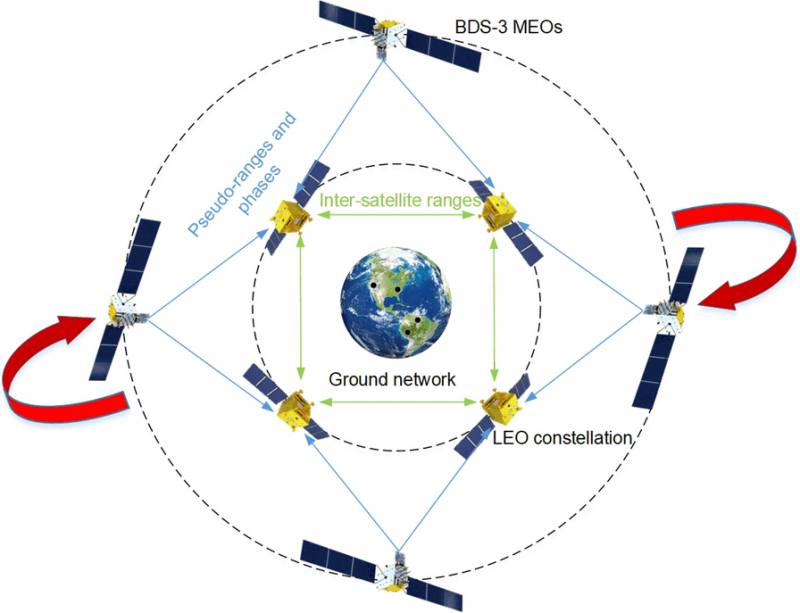
    Modern satellite constellations such as OneWeb, Starlink and CENTISPACE promise global communications and navigation capabilities using low-Earth orbit (LEO) constellations. However, their precise orbit determination (POD) requires dense ground station networks — costly and often limited by geopolitical or geographical constraints.

    Inter-satellite links (ISLs) help reduce ground dependence but suffer from “rotational unobservability,” where the entire constellation drifts in orientation due to the lack of an absolute spatial reference. Existing fixes often require additional infrastructure or high-quality GNSS products, which increase latency and operational complexity.

    Because of these challenges, a more autonomous, low-latency approach that leverages existing onboard capabilities is needed to ensure reliable, high-accuracy orbits for mega-constellations.

    Wuhan University researchers have developed and validated a rotation-corrected integrated POD method that fuses ISL measurements with onboard BeiDou-3 (BDS-3) GNSS observations. Published (DOI: 10.1186/s43020-025-00175-8) in Satellite Navigation on Aug. 4, the study demonstrates how the technique simultaneously estimates the orbits of LEO and BDS-3 medium-Earth-orbit (MEO) satellites, corrects systematic rotation using BDS-3 broadcast ephemerides, and achieves centimeter-level precision.

    The approach significantly reduces reliance on ground stations, making it well-suited for real-time applications in large-scale LEO constellations, the researchers said.

    The team simulated a 66-satellite LEO constellation equipped with ISLs and onboard BDS-3 receivers, alongside 24 real BDS-3 MEO satellites. Two processing strategies were tested: using BDS-3 data from all LEOs, and from only a subset. In both cases, ISL and GNSS data were jointly processed to form a unified high–low constellation.

    Due to internal-only measurements, the initial solutions exhibited significant systematic rotation — up to 40 cm cross-track error for LEOs and over 1 meter for MEOs.

    This innovation could become a cornerstone technology for integrating LEO constellations with existing GNSS systems to enhance global navigation and timing performance.

    The researchers derived rotation angles between the integrated POD coordinate frame and the BeiDou Coordinate System implied in broadcast ephemerides, then applied a Helmert transformation to correct the orbits. After correction, LEO along-track and cross-track errors dropped from 22.7 cm and 39.3 cm to 1.3 cm and 4.2 cm, respectively. MEO errors fell from over 1.2 m to about 13 cm.

    Even when only 36 of 66 LEOs carried GNSS receivers, ISL connectivity propagated the correction across the constellation with minimal accuracy loss. Tests also examined the influence of predicted Earth rotation parameters and residual errors in broadcast ephemerides.

    “This method tackles one of the most stubborn issues in autonomous constellation orbit determination — systematic rotation caused by the lack of absolute spatial reference,” said Kecai Jiang, corresponding author of the study. “By harnessing readily available BDS-3 broadcast ephemerides and inter-satellite measurements, we can deliver centimeter-level precision without waiting for post-processed GNSS products or building extensive ground networks. This approach is not only efficient but also scalable, paving the way for real-time, high-accuracy navigation services in future mega-constellations.”

    The rotation-corrected integrated POD method holds significant promise for global navigation augmentation, autonomous LEO-based navigation systems, and real-time positioning services. By dramatically reducing reliance on ground infrastructure, it enables resilient operations in remote or geopolitically constrained regions. Its scalability makes it suitable for next-generation satellite constellations supporting broadband internet, disaster response, and precision agriculture, the researchers said.

    Moreover, the ability to achieve near-uniform accuracy across all satellites — even when only part of the constellation carries GNSS receivers — lowers hardware requirements and operational costs. This innovation could become a cornerstone technology for integrating LEO constellations with existing GNSS systems to enhance global navigation and timing performance.

  • Ghana launches nationwide CORS network exercise

    Ghana launches nationwide CORS network exercise

    Ghana Lands Commission, through its Survey and Mapping Division (SMD), in collaboration with the Licensed Surveyors Association of Ghana (LiSAG) and GMX Systems Ghana Limited, has launched a nationwide observation exercise for Ghana’s GNSS Continuously Operating Reference Station (CORS) Network.

    This initiative is a major milestone in modernizing the country’s geospatial infrastructure and improving land administration.

    The exercise aims to integrate more than 60 newly established CORS stations into the national geodetic framework, consolidating Ghana’s Grid Coordinate System. The partners plan to expand the network to 100 stations before the end of the year.

    With a modern CORS network, surveyors and spatial data users will have 24/7 access to high-precision data, improved efficiency and cost savings, while aligning Ghana with international geospatial standards.

    It will improve accuracy for land records, agriculture, disaster management, infrastructure development, and revenue generation for the Lands Commission. The observation will be rolled out in three phases — Southern, Middle, and Northern zones — to ensure systematic coverage and data management.

  • U-blox to be bought by Advent International

    U-blox to be bought by Advent International

    U-blox has entered into a binding transaction agreement with ZI Zenith, a subsidiary of Advent International, for $1.3 billion. Under the agreement, ZI Zenith will launch a public tender offer to acquire all publicly held registered shares of u-blox at a price of CHF 135.00 per share in cash.

    Founded in 1997 as a spin-off from the Swiss Federal Institute of Technology in Zurich, u-blox is best known for its affordable and accessible modules that combine microcontrollers, wireless connectivity, and multi-constellation GNSS receivers. Its communications products have also ensured it a slice of the Internet of Things (IoT) market — the company recorded a net profit of SFr101.8 million (around $126 million) in 2021.

    “U-blox is a recognized leader in high-performance positioning and short-range communication technology solutions. We are excited about the opportunity to partner with the u-blox management team and co-founders, and support this innovative technology champion through its next chapter of growth,” said Ronald Ayles, managing partner at Advent. “We are deeply committed to invest in the long-term success of u-blox, using our extensive experience and resources in automotive and industrial end-markets to accelerate innovation and expand its global reach. Advent has a long and successful track record of partnering with founders and management teams to deliver sustainable value creation.”

    The offer represents a 53% premium to the undisturbed volume-weighted average share price of the last 6 months until August 14, 2025, and a 32% premium to the undisturbed volume-weighted average share price of the last 60 trading days of u-blox shares until August 14, 2025, before the media first reported on a potential transaction.

    U-blox’s board of directors has unanimously concluded that the transaction is in the best interests of the company, its shareholders and other stakeholders. It therefore recommends that shareholders accept the offer and has committed, along with the management team, to tender all their shares.

    The board’s recommendation is supported by an independent fairness opinion stating that the offer price is fair from a financial point of view. In addition, u-blox’s largest individual shareholder, SEO Master Fund LP, holding approximately 9% of the outstanding shares, has committed to tender all of its shares.

    The tender offer is subject to terms and conditions as well as regulatory approvals customary for this type of transaction and is expected to be settled within the next six months. The intention is to then delist u-blox shares from the SIX Swiss Exchange.

    The pre-announcement of the offer, which has been published today, is available at www.takeover.ch and www.zenith-offer.com and includes the material terms and conditions of the public tender offer.

  • GöKHUN tactical UAS developed for missions on land, sea

    GöKHUN tactical UAS developed for missions on land, sea

    The GöKHUN unmanned aerial system (UAS) from Turkish company ESEN is a tactical vertical take-off and landing (VTOL) drone system that does not require a runway, offering maximum flexibility in operational use.

    Developed for versatile missions on land or at sea, GöKHUN combines the compact mobility of a NATO Class I UAV with the performance data of a Class II tactical system. The GöKHUN UAS uses the modern SP 210 FI GS 2-stroke engine from Sky Power International.

    With a take-off weight of up to 110 kg and a maximum fuel and payload capacity of 26 kg, the GöKHUN can remain in the air for up to 16 hours with a minimum payload. Even with a demanding sensor load of 12 kg, it can achieve a flight duration of around nine hours, making it suitable for long-endurance reconnaissance and surveillance missions.

    The GöKHUN’s cruising speed is between 96 and 158 km/h. The maximum range with direct line-of-sight is over 150 km, with the system reaching a service ceiling of approximately 5,500 m.

    GöKHUN can take off and land in an area measuring 10 x 10 meters, regardless of topographical conditions and without any infrastructure. This also allows it to be deployed in remote or difficult-to-access regions and on ships.

    The GöKHUN was designed for complex intelligence, surveillance and reconnaissance (ISR) missions. In addition, the system is suitable for a wide range of other applications such as environmental monitoring, disaster relief, border surveillance, anti-smuggling operations and precision agriculture. With its integrated vision-based navigation system GöRDES, the drone is independent of GNSS signals and can be reliably controlled even in GPS-denied environments.

    All safety-relevant systems such as navigation, flight control, data transmission and power supply are designed with double or triple redundancy. If the connection to the ground station is lost, the UAV returns autonomously to its starting point. In addition, GNSS interference protection ensures robust operation even under electronic interference.

    The GöKHUN is also designed for mobility and speed. Two technicians can have the system up and run in around 15 minutes, and it can be transported in two standard vehicles. Thanks to its modular design, the system is easy to maintain and can also be easily adapted to different deployment scenarios. A particularly outstanding feature is its ability to operate two different payloads simultaneously, for example EO/IR sensors for day and night operation or different communication and reconnaissance systems. It is controlled via an integrated ground station with a data terminal, which can also be transferred to other carrier vehicles during an operation.

    The system’s high environmental resistance, with an operating temperature range of −30°C to +55°C, and its ability to fly stably at wind speeds of up to 40 knots underlines its robustness. With its ITAR-free design, GöKHUN meets international export requirements and complies with NATO standards AEP-83/84. The system can be easily integrated into existing tactical networks, making it attractive to international partners.

    Overall, GöKHUN combines tactical range, modular architecture, simple logistics and operational independence. With its high endurance, vertical take-off capability and safe mission execution in complex environments, the system is ideal for modern applications in security-critical but also in civil areas, whether for border surveillance, disaster relief or as an ISR platform at sea. Its independence from GNSS signals and flexible payload configuration make the GöKHUN UAS a state-of-the-art solution in the field of unmanned aerial reconnaissance.

  • Septentrio teams up with Gateworks, broadening its mosaic ecosystem

    Septentrio teams up with Gateworks, broadening its mosaic ecosystem

    Septentrio is collaborating with Gateworks Corporation, a US-based manufacturer of high-quality single board computers. Gateworks is now bringing its first Septentrio-based product to market, a new M.2 card called GW16160, which provides reliable high-accuracy positioning powered by the mosaic-X5 GNSS module.

    The mosaic-X5 module is a multi-frequency, multi-constellation receiver renowned for its high level of resilience to GNSS jamming and spoofing, thanks to the built-in AIM+ (Advanced Interference Mitigation) technology. It also features a suite of GNSS+ algorithms that ensure robust positioning of rugged systems operating in challenging industrial environments.

    The GW16160 card with mosaic-X5 is a high-quality positioning solution for autonomous robots, UAVs and industrial mission-critical applications.

    Designed and manufactured in the USA, the GW16160 allows engineers to integrate high-accuracy GNSS into edge systems without bulky external receivers or complex RF design. This ultra-low power card features an M.2 A/E-Key interface with USB 2.0 connectivity for plug-and-play integration. 

  • STM unveils defense innovations BOYGA-B and TUNGA at IDEF 2025

    STM unveils defense innovations BOYGA-B and TUNGA at IDEF 2025

    STM unveiled two of its latest innovations at IDEF 2025: the BOYGA-B rotary-wing UAV, capable of carrying multiple munitions, and the TUNGA Smart Munition System. IDEF, the International Defense Industry Fair, is a globally recognized trade fair in the defense industry, ths year hosted by Türkiye in Istanbul July 22-27.

    The BOYGA-B Ammunition Drop UAV is engineered for tactical missions such as reconnaissance, surveillance, target detection and precision munition deployment. The system can carry smart munitions as well as two 81 mm UAV munitions.

    The TUNGA Smart Munition System, developed for anti-personnel missions, has a modular design, image-based or GNSS-based guidance, and proximity-fuze detonation capability. Both new systems are designed to meet the evolving needs of modern combat environments.

    BOYGA-B Ammunition Drop UAV

    BOYGA-B is a high-precision rotary-wing UAV designed for reconnaissance, surveillance, target engagement and precision munition deployment in tactical operations. It can operate in GNSS-denied or jammed environments with its CRPA antenna and KERKES integration. The system can carry up to 8 kg of munitions and precisely release them onto targets using its integrated drop mechanism.

    Key Features

    • GNSS-denied operation via CRPA and KERKES
    • Flight time: 35 minutes
    • Range: Minimum 5 km
    • Operable by a single soldier
    • Target detection and tracking
    • Real-time EO/IR image transmission
    • Autonomous munition release and mission abort

    Payload Options

    • 2× 81 mm UAV Munitions
    • 1× TUNGA Smart Munition
    • 1× Kargu FPV Drone

    TUNGA Smart Munition System

    TUNGA is a glide-type guided munition developed by STM for anti-personnel missions. Equipped with a 1750 g warhead, TUNGA can be precisely guided to its target using EO/thermal imaging and onboard image processing. It offers safe operation with self-destruct functions and can be deployed from BOYGA-B or other compatible platforms.

    Key Features:

    • GNSS or image-based guidance
    • Self-destruct options
    • Modular design for different mission profiles
    • Low visibility with EO/thermal imaging
    • Proximity-fuse detonation

    Technical Specifications

    • Length: 540 mm
    • Warhead: 1750 g
    • Endurance: 30 minutes
    • Operational altitude: 300–800 m
  • JAVAD GNSS unveils new data collection software

    JAVAD GNSS unveils new data collection software

    Javad GNSS has released its latest data collection software, Javad Data Collector (JDC). Designed to run seamlessly on any Android device, JDC interfaces effortlessly with the company’s modern line of smart antennas.

    JDC features simple, intuitive workflows that require minimal training, making it accessible for users of all skill levels. The software includes a Signal Bar for a quick view of receiver status, ensuring users can easily monitor their equipment’s performance. Additionally, JDC offers easy navigation, allowing users to move through the software with efficiency.

    “Our goal with JDC was to create a tool that not only meets but exceeds the needs of our diverse clientele,” said Gary Walker, executive vice president, JAVAD GNSS. “We understand the demands of the full spectrum ranging from the individual surveyor to larger surveying firms, construction and engineering firms, as well as government entities. JDC is designed to streamline their operations, making it easier to deploy and manage receivers across teams of any size with minimal training.”

    JDC is available for download through the company’s official website. Customers can evaluate the full functionality of JDC with limited point storage and may request a license when ready to integrate it into their workflow.

  • Xona Pulsar satellites to leverage Astroscale tech for resilient and secure navigation

    Xona Pulsar satellites to leverage Astroscale tech for resilient and secure navigation

    Astroscale of the UK will provide Xona Space Systems with next-generation docking plates for integration into Xona’s growing constellation of low Earth orbit (LEO) satellites. The collaboration supports two critical goals: building a resilient positioning, navigation and timing (PNT) infrastructure and keeping Earth’s orbit safe and sustainable.

    Xona is developing Pulsar, an advanced PNT satellite infrastructure based in LEO. Pulsar operates alongside legacy systems like GPS, delivering stronger signals, centimeter-level precision, and built-in protection against interference including jamming and spoofing. As threats to global navigation escalate, a more resilient and secure PNT architecture has become essential for national security, critical infrastructure and connected devices around the world.

    “Resilient PNT is a national and economic priority,” said Giorgio Taylor, Director of Business Development, Xona UK & Europe. “Pulsar delivers stronger, faster, and more secure navigational intelligence designed for the threats we face today. Our work with Astroscale reinforces our belief that space infrastructure should evolve to continue meeting user needs, not remain frozen in time.”

    Astroscale will provide docking plates for Xona’s future Pulsar satellites as the company scales to launch its full constellation, allowing for future in-orbit servicing, upgrades or safe deorbiting. This supports a more flexible and responsive satellite architecture and helps prevent space debris. These are both key parts of responsible space operations.

  • HawkEye 360 launches advanced GNSS interference detection capabilities

    HawkEye 360 launches advanced GNSS interference detection capabilities

    HawkEye 360 has made powerful enhancements to its GNSS Interference (GNSS-I) Detection product suite. The upgrades — designed with defense, intelligence and national security operations in mind — offer unprecedented accuracy, coverage and insight into global GPS jamming and spoofing threats.

    The update includes a new wider frequency algorithm that better distinguishes individual emitters, incorporates GPS spoofing detection, and is terrain adjusted for better geolocation accuracy, delivering greater situational awareness and more precise geolocation of interference sources worldwide.

    HawkEye 360’s enhanced GNSS Interference Detection product suite supports strategic decision-making by providing timely, precise insight into potential signal disruptions, enabling stakeholders to better assess risk, respond confidently, and maintain operational continuity in dynamic environments.

    With this release, HawkEye 360’s GNSS-I Detection product suite now provides:

    • 15 times increase in geolocation density
    • Spoofing detection and differentiation
    • Terrain adjusted for increased accuracy
    • Consistent monitoring across wide areas of interest

    HawkEye 360’s new spoofing detection capability identifies potentially malicious transmitters that imitate legitimate GPS course/acquisition (PRN) codes — a tactic increasingly used to deceive aircraft and mislead navigation systems. The capability supports threat mitigation and trend analysis by detecting and geolocating these spoofers down to a kilometer-level precision.

    “In contested environments, timely RF intelligence is the key to mission success,” said Alex Fox, president, International Business Unit. “Traditional land, sea, and air systems struggle in Anti-Access/Area Denial environments, while our satellites provide global GNSS-I detection and geolocation coverage. These enhanced capabilities give defense and intelligence teams the ability to identify and neutralize threats before they disrupt operations, enabling faster decisions and sharper visibility into adversary behavior.”