Author: Tracy Cozzens

  • Companies join on E112 caller location compliance for Europe

    Companies join on E112 caller location compliance for Europe

    Collaboration supports emergency services across the European Union

    Galileo-supported E112 will result in faster response times and more lives saved. (Image: EUSPA)
    Galileo-supported E112 will result in faster response times and more lives saved. (Image: EUSPA)

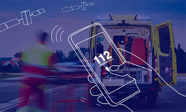
    Keysight Technologies Inc. is collaborating with DEKRA to ensure that chipset and device vendors can validate E112 caller location (universal European emergency number) functionality in compliance to a new European Union (EU) regulation.

    The collaboration leverages GNSS and c (LBS) to verify E112 regulatory test cases used to validate mobile phones sold into the European market. The new regulation supports emergency services across the European Union by reducing response times from rescue services to save more lives.

    “Keysight is pleased to expand the company’s collaboration with DEKRA,” said Muthu Kumaran, general manager of Keysight’s Device Validation Solutions business. “With Keysight’s test solutions, DEKRA supports a global ecosystem of smartphone vendors by validating that their products are in compliance to the new regulation, newly created to improve emergency services’ ability to locate individuals in need of assistance from the fire brigade, medical teams or the police.”

    Keysight’s network emulation solutions enable DEKRA to validate E112-related test cases regulated by an EU-issued guideline document to assist notified bodies in the assessment of E112 compliance. The new EU regulation (Delegated Regulation (EU) 2019/320) went into effect on March 17, 2022. It mandates that all new mobile phones sold in the EU need to support GNSS technology based on the Galileo constellation, advanced mobile location (AML) protocol and Wi-Fi communications technology. As a result, emergency response call centers can accurately pinpoint the caller’s location.

    “DEKRA is founded on the principles of safeguarding human interaction with technology and environment,” said Juan Carlos Mora, vice president, Business Line Connectivity of Service Division, Product Testing at DEKRA. “This is why we are pleased to extend our collaboration with Keysight, which offers DEKRA the regulatory device test solutions needed to quickly and confidently validate E112 caller location functionality per the EU’s latest mandatory requirements.”

    Keysight’s device test solutions for regulatory and conformance validation are based on common hardware and software platforms for comprehensive test-case coverage. Keysight’s LBS solutions also support assisted GNSS (A-GNSS) test functionality. This enables users to comprehensively address 5G new radio (NR) conformance requirements mandated by the Global Certification Forum (GCF) and PTCRB, an organization comprised of North American mobile operators.

    DEKRA uses Keysight’s RF/RRM DVT & Conformance ToolsetRF Automation Toolset and Wireless IoT Regulatory Test Solution to address 5G and internet of things (IoT) device regulatory requirements and SA8700A C-V2X Test Solution to certify cellular vehicle-to-everything (C-V2X) devices.

  • Emlid Studio released for GNSS post-processing

    Emlid Studio released for GNSS post-processing

    Image: Emlid
    Image: Emlid

    Emlid has released Emlid Studio, a new post-processed  kinematic (PPK) application designed specifically for post-processing GNSS data. The app is free and available for Windows and Mac users.

    Emlid Studio features a simple interface to make post-processing easy. The app allows users to convert raw GNSS logs into RINEX, post-process static and kinematic data, geotag images from drones (including DJI brand), and extract points from survey projects completed with Emlid’s ReachView 3 app.

    With Emlid Studio, users can post-process data recorded with Emlid Reach receivers and other GNSS receivers or NTRIP services. Post-processing requires RINEX observation and navigation files. Raw data in UBX and RTCM3 format also can be used — Emlid Studio will automatically convert them into RINEX.

    The post-processing workflow is straightforward. Users can receive precise positioning of a single point or track depending on the positioning mode. Users can simply add several RINEX files and enter the antenna height, click the Process button, and Emlid Studio will do the rest. Once the resulting position file is ready, the plot will show the result.

    Another tool is available for the users of Reach receivers and the ReachView 3 app. The Stop & Go feature allows users to improve the coordinates of points collected in single or float modes.

    Geotagging for drone mapping. Adding geotags to images’ EXIF data requires aerial photos and the POS file with the events. Emlid Studio also provides a chance to update data from the RTK drone in case of a float or single solution during a survey. A set of RINEX logs from a base and drone, an MRK file and images from the drone are dragged and dropped into specific file slots, providing result in seconds.

  • OSNMA anti-spoofing tech now on PolaRx5 GNSS reference receivers

    OSNMA anti-spoofing tech now on PolaRx5 GNSS reference receivers

    The Septentrio PolaRX5. (Photo: Septentrio)
    The PolaRX5 GNSS reference receiver. (Photo: Septentrio)

    Septentrio, a leader in high-precision GNSS positioning solutions, has launched Open Service Navigation Message Authentication (OSNMA) on its high-end PolaRx5 reference receiver series.

    OSNMA offers end-to-end authentication on Galileo’s civilian signals, protecting receivers from GNSS spoofing attacks. OSNMA adds another layer of security to Septentrio’s existing AIM+ anti-jamming and anti-spoofing technology.

    This high level of resilience is especially important for reference receivers in applications that require assured PNT as well as in stationary critical infrastructure, which is especially vulnerable to GPS spoofing.


    The Septentrio PolaRx5 receiver with OSNMA technology will be showcased in booth 220 at the ION Joint Navigation Conference, taking place June 6-9 in San Diego.


    “We are excited to offer OSNMA anti-spoofing technology now in our scientific and reference GNSS receivers,” said François Freulon, head of product management at Septentrio. “The addition of OSNMA to Septentrio’s already strong anti-jamming and anti-spoofing technology takes our receivers to a new level as resilient positioning and timing solutions for industrial applications and critical infrastructure.”

    Septentrio has also updated the PolaRx5 product range with the latest RINEX format to support version 3.05 as well as version 4.0. With these updates, PolaRx5 becomes a leading scientific and reference receiver family supporting all of the new GNSS technologies introduced in 2022, Freulon said.

    The OSNMA authentication mechanism is also available on the mosaic GNSS module family and on Septentrio’s latest OEM boards.

  • Spirent Federal announces guest speakers for July training seminar

    Spirent Federal announces guest speakers for July training seminar

    Representatives from the U.S. Space Force and U.S. Army will present

    Photo:

    Spirent Federal, a leading provider of positioning, navigation and timing (PNT) test equipment, has announced the guest speakers for the 2022 Spirent Federal PNT Training Seminar.

    Guests include Stephen Burke from Space Systems Command and Ivan Franklin from the Assured Positioning, Navigation and Timing/Space (APNT/Space) Cross-Functional Team (CFT).

    The seminar will take place in person in Huntsville, Alabama, July 12-13, and will provide extensive training on PNT applications using Spirent’s simulation solutions.


    Spirent Federal Systems is exhibiting at the ION Joint Navigation Conference, which takes place June 6-9 in San Diego.


    Burke will provide an update on Military GPS User Equipment (MGUE) for Increment 1 and Increment 2, as well as a briefing on the Space Systems Command PNT restructure. Burke is deputy to the Senior Materiel Leader, GPS User Equipment Acquisition Delta, for the Military Communication and PNT Directorate within U.S. Space Force Space Systems Command.

    Franklin, Deputy APNT Signature Effort for the U.S. Army APNT/Space CFT, will share the latest on U.S. Army APNT, which is influencing the way soldiers operate in degraded and denied environments.

    “Providing hands-on training for customers, or prospective customers, and discussing nascent PNT advancements at our annual training seminar is the highlight of our year,” said Roger Hart, director of engineering for Spirent Federal. “We work closely with the U.S. government and military and are pleased Stephen and Ivan have accepted our invitations to share their vital information and expertise with the attendees.”

    Other seminar topics include

    • advanced jamming and in-the-field spoofing mitigation
    • encrypted GPS M-code and Y-code
    • complementary PNT, including inertial navigation systems
    • controlled reception pattern antennas (CRPA)
    • a patented approach to testing in anechoic chambers.

    View the full agenda and more information on registration at spirentfederal.com/training.

  • BAE Systems broadens compatibility of anti-jam GPS receiver

    BAE Systems broadens compatibility of anti-jam GPS receiver

    Image: BAE Systems
    Image: BAE Systems

    BAE Systems has expanded the capabilities of its Digital GPS Anti-Jam Receiver (DIGAR) by enabling beamforming with Trimble receivers, in addition to its own receivers.

    DIGAR’s beamforming capabilities increase the level of GPS jamming protection for aircraft by a million-fold, helping pilots execute their missions in contested environments.

    BAE Systems’ engineers in Cedar Rapids, Iowa, developed software to ensure the compatibility of its antenna electronics with industry-standard embedded GPS inertial navigation system (GPS/INS) technology, enabling fast communication with transmitter electronics for superior beamforming.


    BAE Systems is exhibiting at the ION Joint Navigation Conference, which takes place June 6-9 in San Diego.


    DIGAR beamforms with both BAE Systems receivers and Trimble GPS receivers embedded in aircraft GPS/INS, as well as federated GPS systems and stand-alone GPS receivers.

    “The modern battlespace has evolved, and peer state positioning, navigation, and timing threat systems are challenging our ability to conduct combat operations in the place and manner of our choosing,” said Greg Wild, director of Navigation and Sensor Systems at BAE Systems. “By combining DIGAR’s beamforming with trusted inertial navigation system data, we offer the highest level of jamming protection available today.”

    DIGAR is a high-performance military GPS-based system for fixed-wing, rotary-wing and unmanned airborne platforms. It combines field-proven antenna electronics, advanced signal-processing, and beamforming techniques to improve the reliability of positioning, navigation and timing data in the presence of disruptive electromagnetic signals.

    DIGAR is also compatible with the advanced M-code – delivering additional security to the warfighters who rely on it.

    BAE Systems’ anti-jamming GPS technology has defeated powerful and sophisticated adversary threat systems in testing and combat, and is available for airborne, shipborne and ground vehicle applications. The company’s military GPS business is based in Cedar Rapids, Iowa, where it is building a 278,000-square-foot state-of-the-art research and manufacturing facility scheduled to open this year.

  • Nestwave white paper considers power consumption for IoT devices

    Nestwave white paper considers power consumption for IoT devices

    Nestwave logoNestwave has released a white paper that considers the challenges associated with integrating accurate geolocation into compact, battery-powered, low-cost internet of things (IoT) nodes.

    The technical paper “Minimizing Power Budgets to Enable Geolocation on Every IoT Device” is targeted at engineers and developers looking to add accurate positioning functionality to IoT technologies where power requirements must be kept to an absolute minimum.

    Topics covered include:

    • why conventional tracking architectures are not suitable for many IoT implementations
    • the importance of factors such as time-to-first-fix (TTFF)
    • the number of fixes and levels of integration in determining power consumption.

    The paper introduces new ways of handling positioning signal acquisition, ranging and tracking, and proposes solutions that eliminate the need for a separate GNSS-integrated circuit and that offload energy-intensive computation to the cloud.

    “Tracking will be an important element in the evolution of the IoT, which means making accurate geolocation viable for every single IoT node is absolutely critical,” said Ambroise Popper, Nestwave CEO. “This paper explains why traditional solutions are too power-hungry, too large and too expensive to meet the energy, form factor and cost constraints of most IoT devices and introduces solutions for addressing the challenge.”

  • Pozyx Platform provides seamless indoor/outdoor tracking

    Pozyx Platform provides seamless indoor/outdoor tracking

    The Pozyx Platform is an asset tracking and identification solution for seamless indoor and outdoor tracking, based on the omlox hub and supporting multiple location technologies.

    The omlox hub is an open standard for real-time location systems (RTLS) that combines location data from GPS, ultra-wideband, 5G, radio-frequency identification, Wi-Fi and Bluetooth.

    The Pozyx Platform offers a seamless indoor/outdoor transition with zoom-in from a worldwide map to a detailed indoor map, showing highly accurate locations up to 10 cm. It is designed for smart manufacturing, providing a supply-chain solution that supports Industry 4.0.

    It tracks and identifies any asset, providing real-time data to facilitate warehouse and inventory control, keep track of critical tools, and slash lost asset costs.

    Image: Pozyx
    Image: Pozyx
  • Industry coalition pushes back against Canadian ADS-B mandate

    Industry coalition pushes back against Canadian ADS-B mandate

    Photo: MJ_Prototype/iStock Editorial/ Getty Images Plus/Getty Images
    Photo: MJ_Prototype/iStock Editorial/ Getty Images Plus/Getty Images

    An aviation industry coalition is voicing concern to Transport Canada about elements of a proposed mandate that will require aircraft flying in Canada to be equipped with the Automatic Dependent Surveillance-Broadcast (ADS-B), also called the Next Generation Air Transportation System, or NextGen.

    ADS-B uses GNSS technology to calculate an airplane’s precise location, speed and direction. This information is transmitted twice per second, providing greater situational awareness for air traffic controllers.

    The mandate in Canada requires aircraft to implement 1090ES ADS-B in two phases over the next four to five years. It takes effect for Class A and B Canadian airspace (above 12,500 feet) on Feb. 23, 2023, and Class C, D, and E airspace no earlier than 2026.

    Space-Based Transceivers

    The proposed mandate will also require antennas capable of communicating with both ground-based and space-based transceivers (referred to as antenna diversity). The United States uses ground-based ADS-B stations, which are confined to line-of-sight reception between the aircraft and ground receivers.

    Space-based ADS-B does not have this limitation, but requires antennas on top of the aircraft to provide the required fidelity to allow for air traffic separation.

    “This would constitute an equipage mandate for most U.S. operators wanting to fly to Canada, most of which have recently equipped to meet U.S. requirements,” said Jim McClay, director of airspace, air traffic and security for the Aircraft Owners and Pilots Association (AOPA). “To comply, many operators will need to install new antennas on top of their aircraft as well as possibly replace their ADS-B units. The costs of complying will be significant and would be borne only by aircraft owners.”

    A recent AOPA survey of members in border states revealed that most U.S. operators are unaware of the coming mandate and almost half of respondents who regularly fly to Canada indicated they would cease flying to Canada altogether in the face of the mandate.

    Lack of Installers

    The industry coalition also agrees that it is highly doubtful that there are enough avionics installers to complete the needed upgrades in time to meet the mandate’s deadlines.

    “Due to these concerns, AOPA is urging a delay of the Nav Canada equipage mandate until a determination can be made on the cost impact to purchase and install the required equipment and discussions on potential alternative solutions are held,” McClay said.

    Other Countries

    According to Nav Canada, the equipage requirements of Canada’s ADS-B mandate are in line with those of a growing number of other countries in the world. “The adoption of satellite-based surveillance technology ensures long-term alignment with the global aviation system,” the company stated. Nav Canada provides services to Canadian airspace such as air traffic control and weather advisories.

    Members of the coalition include the Canadian Owners and Pilots Association, General Aviation Manufacturers Association, Garmin, the Canadian Business Aviation Association, AOPA and others.

    Coalition members share concerns that the mandate being pursued by Nav Canada and Transport Canada does not appear to be going through the full consultative process, and will submit their concerns over the next several weeks.

  • Google ARCore Geospatial API expected to power new apps

    Google ARCore Geospatial API expected to power new apps

    Bird uses the ARCore Geospatial API to enable a scooter parking app. (Image: Bird)
    Bird uses the ARCore Geospatial API to enable a scooter parking app. (Image: Bird)

    Google has launched the ARCore Geospatial API in ARCore software development kits (SDKs) for Android and iOS across all compatible ARCore-enabled devices.

    The application programming interface (API) is available at no cost to download and opens up nearly 15 years of Google Maps data to help developers build more useful and immersive augmented reality (AR) experiences.

    “The Geospatial API provides access to global localization — the same technology that has been powering Live View in Google Maps since 2019, providing people with helpful AR-powered arrows and turn-by-turn directions,” explains a Google blog.

    “Based on the Visual Positioning Service (VPS) with tens of billions of images in Street View, developers can now anchor content by latitude, longitude and altitude in more than 87 countries, without being there or having to scan the physical space, saving significant time and resources.

    “For end users, discovering and interacting with AR is faster and more accurate as images from the scanned environment are instantaneously matched against our model of the world,” the blog states. “This model is built using advanced machine-learning techniques, which extract trillions of 3D points from Street View images that are then used to compute a device’s position and orientation in less than a second.

    “In other words, users can be anywhere Street View is available, and just by pointing their camera, their device understands exactly where it is, which way it is pointed and where the AR content should appear, almost immediately.”

    Early-access partners include the NBA, Snap and Lyft, who are exploring and building applications in areas such as education, entertainment and utilities. For example, micromobility companies Bird, Lime and WeMo are using the API to remove friction from parking e-scooters and e-bikes, adding pinpoint accuracy so that riders know exactly when their vehicle is in a valid parking spot. Lime has been piloting its app in London, Paris, Tel Aviv, Bordeaux, Madrid and San Diego.

  • Septentrio showcases solutions for GPS jamming and spoofing

    Septentrio showcases solutions for GPS jamming and spoofing

    Septentrio will demonstrate how simple it is to spoof or jam unprotected GPS receivers at the upcoming ION Joint Navigation Conference, which takes place June 6-9 in San Diego. The company will showcase how its resilient technology makes a difference for overall security and availability of positioning, navigation and timing (PNT) .

    Photo: Septentrio
    The AsteRx-U3 receiver. (Photo: Septentrio)

    Septentrio will hold a GPS spoofing demonstration, as well as a detailed comparison of jamming solutions from various high-end receivers. The integration of the latest anti-spoofing authentication mechanism, Galileo’s Open Service Navigation Message Authentication (OSNMA), will also be shown.

    “With our growing dependence on GPS technology, resilience of PNT is an important point of attention, especially for mission-critical applications, tactical ground or aerial vehicles as well as autonomous systems,” said Gustavo Lopez, market access manager, Septentrio. “Since the number of malicious jamming and spoofing attacks is on the rise, it is crucial to understand how various GPS receivers can be affected. We are pleased to explain and display this with specific examples at JNC this year.”

    Advance Interference Mitigation (AIM+) is an interconnected set of sophisticated anti-jamming and anti-spoofing technology components, securing GPS/GNSS receivers against various forms of interference.

    AIM+ is an interconnected set of anti-jamming and anti-spoofing technology components comprising a robust defense system against various forms of GPS/GNSS interference. Such resilience to jamming combined with anti-spoofing measures ensures the safety of autonomous machines, improves the security of GNSS-based infrastructure, and increases efficiency with extended PNT availability.

    OSNMA anti-spoofing authentication from Galileo is available on Septentrio receivers such as the mosaic module as well as the recently released AsteRx-U3 boxed receiver. Other products such as AsteRx-SBi3 also add inertial sensors for increased protection against spoofing.

    Septentrio will be at booth 220 in the ION JNC exhibit hall.

  • Hexagon | NovAtel joins Xona on assured PNT LEO constellation

    Hexagon | NovAtel joins Xona on assured PNT LEO constellation

    The launch of Xona’s test satellite begins a new era of innovation in assured PNT, with NovAtel receivers demonstrating early support of Xona’s signals

    Hexagon | NovAtel has signed a memorandum of understanding with Xona Space Systems to collaborate in the positioning, navigation and timing (PNT) development of Xona’s new low-Earth orbit (LEO) constellation.

    LEO constellations offer a new avenue of assuring PNT by providing stronger signals with satellites closer to Earth and improved positioning accuracy with rapidly changing geometry, NovAtel explained. Additional constellations and a larger number of available satellites improve visibility in cases where parts of the sky are obstructed by buildings and other obstacles.

    Also, as the threat of unintentional or malicious jamming and spoofing increases, it becomes important to consider alternative sources of PNT and resiliency methods, the companies said.

    “Precise and robust PNT forms the foundation for safe operation of modern applications such as automotive and autonomy,” said Brian Manning, CEO of Xona. “We are thrilled to be collaborating with NovAtel to demonstrate the benefits that our combined technologies can bring to these markets and many more.”

    Xona’s new constellation will transmit encrypted signals on two frequencies, both offering authentication, further building new levels of resilience against malicious interference. NovAtel is an early adopter of Xona’s signals and an industry leader in resilient assured PNT.

    “This agreement accelerates the future of alternative PNT,” said Sandy Kennedy, vice president of innovation at Hexagon’s Autonomy & Positioning division. “Our collaboration will demonstrate the complete assured PNT ecosystem that Xona has envisioned, and of which NovAtel is very excited to be part.”

    Xona and NovAtel will be presenting innovations in assured PNT and the future of GNSS at the Autonomy & Positioning Reality Summit during HxGN LIVE Global in Las Vegas, June 20-23.

    Image: Xona Space Systems
    Image: Xona Space Systems
  • GeoSLAM launches ZEB Vision 4K panoramic camera

    GeoSLAM launches ZEB Vision 4K panoramic camera

    Colorization and immersive walkthroughs among major updates to geoSLAM solutions

    The ZEB Vision 4K panoramic camera. (Photo: GeoSLAM)
    The ZEB Vision 4K panoramic camera. (Photo: GeoSLAM)

    GeoSLAM has launch the ZEB Vision 4K panoramic camera, which allows users to capture and process colorized data faster than previous company products.

    The company also updated its Connect software platform. Both are designed to accompany GeoSLAM’s ZEB Horizon scanner.

    With easy deployment via handheld or backpack, the ZEB Vision’s 4K resolution, 360° panoramic image capture and colorization capabilities add a new perspective to visualizing a point cloud. Images are captured simultaneously during a scan, without the need to stop and take photos.

    With Connect software, data captured with the ZEB Vision can be easily colorized, without the need for third-party software.

    Users can achieve greater understanding and visibility of the data capture environment with an immersive walkthrough, so they don’t have to be the person capturing the data to see it clearly.

    “Being able to add context to data, through colorization and image capture, is invaluable, particularly for those working in the surveying, architecture and infrastructure sectors, where the extra details can make all the difference,” said Neil Slatcher, chief product officer, GeoSLAM.

    “Our customers completely own the data and images they collect at no extra cost. We are working hard to make capturing geospatial data as easy as possible, from our walk and scan method of data collection to automated workflows. Teaming the ZEB Vision with our updated Connect software will simplify this process even further.”

    Besides RGB colorization, new automation options for ZEB users include:

    • Automatic Data Cleaning. A range of new data filters and classifiers within Connect 2.1 provides greater point-cloud clarity by removing outliers and other unwanted points such as people and vehicles.
    • Measuring Tool. Distances between points within any dataset can be measured for quick and accurate analysis.

    Existing GeoSLAM customers with a Care subscription can freely update to Connect 2.1; any new products shipped will come with the software, providing users will full ownership of their data.

    A colorization data set of GeoSLAM’s headquarters in Nottingham, UK, captured with a ZEB Vision camera. (Image: GeoSLAM)
    A colorization dataset of GeoSLAM’s headquarters in Nottingham, UK, captured with a ZEB Vision camera. (Image: GeoSLAM)