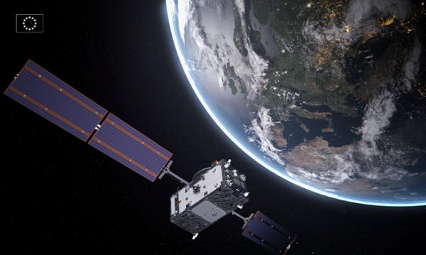
After a challenging Launch and Early Orbit Phase (LEOP) and testing campaign during the COVID-19 pandemic, Galileo satellite “Nikolina” (GSAT0223) entered service on May 5. The satellite will reinforce the performance and robustness of the Galileo satellite.
GSAT0223 was launched Dec. 5, 2021 with Galileo launch L11 after the usual design, acceptance, validation, launch and early orbit preparation and operations phases.
This was the first Early Orbit Operations phase conducted directly from the operational center in Germany, under the responsibility of EUSPA.
GSAT0223 and its launch companion GSAT0224 (Shriya) are the first pair of the third batch of Galileo First Generation satellites to reach space. GSAT0223 will fill the last empty slot in Galileo’s orbital plane B.
Shriya will soon complete its in-orbit validation and will then join the operational constellation. Ten additional satellites of the same batch are continuing assembly, acceptance and launch preparations.
Topcon Positioning Germany is one of 22 partners involved in CampusOS, a research project with the goal of developing a modular ecosystem for open 5G campus networks based on open radio technologies and interoperable network components.
As part of the German technology program “Campus networks based on 5G communication technologies,” innovative solutions for open 5G networks are being developed and tested in conjunction with the German Federal Ministry for Economic Affairs and Climate Protection. The program was launched at the beginning of 2022 and will run through 2025.
The use of artificial intelligence in the operation of autonomous plants and construction machinery requires the highest level of digital sovereignty. If Construction 4.0, including far-reaching automation, is to become a reality in Germany and the rest of the world, the processes of such data-driven solutions must run reliably, quickly and autonomously.
The German Federal Ministry for Economic Affairs and Climate Protection is providing €18.1 million in funding for the technology program over the next three years, which will cost €33 million total. The Fraunhofer Institutes FOKUS and HHI are coordinating the project. 22 partners from industry and research are involved, including Deutsche Telekom, Siemens, Robert Bosch and more.
“To enable companies to operate their own campus networks, certain requirements must be met; from standardized technology building blocks to network structures,” explained Ulrich Hermanski, chief marketing officer of the Topcon Positioning Group. “As the sole representative of the construction industry, Topcon will test the technologies on reference test sites and, therefore, will help shape the solutions for the future. We look forward to working with our research partners to take the digital construction site to the next level.”
With this research project, construction companies will one day be able to operate plants and machinery autonomously in open campus networks. This will allow the fluid and uninterrupted monitoring of construction sites in real time, as well as the networking of all sensors and construction machines in use on construction sites.
Autonomous from public networks, 5G technology guarantees seamless machine-to-machine communication and transmits data 10 times faster than 4G.
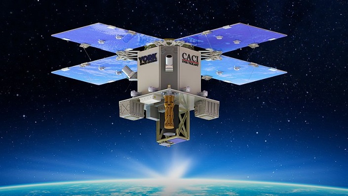
Artist’s impression of the CACI/York Space DemoSat scheduled to launch in January 2023. (Credit: CACI)
CACI International, a U.S. defense contractor, plans to demonstrate a supporting navigation technology for military use as part of its DemoSat launch in January 2023.
CACI will launch two demonstration payloads on a York Space Systems satellite scheduled to fly to low Earth orbit in January aboard the SpaceX Transporter 7 rideshare.
The payload will contain an alternative positioning, navigation and timing solution that will work in a contested space domain. It is designed to support rather than replace GPS.
The technology is two-way time transfer and clock modeling technology. Two-way time transfer has been used for years on the ground, but in this case will be used in space. The low size, weight and power (SWaP) space-based PNT is expected to significantly improve multi-platform remote sensing.
If the experiment is successful, CACI plans to offer the two-way time transfer PNT service to the military and other government agencies.
CACI has completed the critical design review for the DemoSat. CACI and its partner York Space Systems will also demonstrate a tactical intelligence, surveillance and reconnaissance (TacISR) payload. The TacISR payload identifies and captures key signals of interest and operates with CACI’s Beast ground receiver to demonstrate real-time radiofrequency geolocation for deployed U.S. forces.
“CACI expertise, systems, and technology help our customers maintain dominance in the increasingly contested space environment,” said Mike Hale, executive vice president of CACI’s Advanced Solutions Group. “We are very proud that CACI is launching a DemoSat payload into orbit – distinguishing our mission technology and transformative solutions for customer success.”
Tersus GNSS has released a white paper on ExtremeRTK Technology. According to the company, the white paper demonstrates how ExtremeRTK Technology delivers excellent performance in all manner of surveying scenarios and describes its impressive compensated results when performing tilt surveys — even tilt at angles greater than 90°.
As a professional real-time kinematic (RTK) developer and manufacturer, Tersus believes the stability and accuracy of RTK are the cornerstones of RTK measurement.
According to the paper, “ExtremeRTK integrates the receiver’s hardware, high-precision baseband IC [integrated circuit], RTK engine, GNSS/INS coupling algorithm, etc. It enables unprecedented performance stability in challenging environments and prevents occurrences of occasional RTK positioning outliers.”
Tersus starts from scratch — engineering each element from its foundation in the physics of GNSS. From signal capture and baseband tracking engine to position-velocity-time (PVT) results and the overall algorithm of RTK, Tersus completes all algorithm logic independently.
The white paper discusses:
signal tracking and multipath mitigation capabilities
fix speed in open-sky and challenging environments
accuracy when performing RTK control/detail point/continuous point surveys
GNSS/INS tilt compensation.
Test results described indicate the remarkable performance of ExtremeRTK technology in RTK initialization, accuracy and tilt compensation. Based on ExtremeRTK, Tersus will continue to invest in the further development of RTK receivers by adding photogrammetry, laser scanning and more.
Meanwhile, Tersus will also focus research and development on professional industry software, the integration of resources in data management, and big-data applications so it can provide users with additional professional services.
“Seen & Heard” is a monthly feature of GPS World magazine, traveling the world to capture interesting and unusual news stories involving the GNSS/PNT industry.
Image: Stadium, OnePlan/Paris 2024 Organizing Committee for the Olympic and Paralympic Games
PARIS OLYMPICS GET DIGITAL TWIN
In an Olympic first, the 2024 Olympics and Paralympics in Paris will receive a digital twin for planning and collaboration. OnePlan’s GIS Mapping and Venue Twin software will be used to create a 3D map of each sports venue and surrounding areas to help event planners, partners and suppliers collaborate in real time. They will be able to see spaces and capacities at any angle, in any light, in any weather condition at any time. Infrastructure such as barriers, fencing, vehicles, teams, volunteers and broadcast cameras can be positioned in the twin. Organizers can plan for any scenario, improving efficiency and safety, as well as take the needs of the disabled into account.
Photo: DeepRoute.ai
HOW WILL THEY SPEND THEIR TIPS?
A fleet of 30 “Robotaxis” – Level 4 autonomous cars – will hit the streets in Shenzhen, China, to showcase an autonomous solution by DeepRoute.ai. The Robotaxis – SAIC Motor SUVs outfitted with DeepRoute.ai’s Driver 2.0 – preview plans for mass production of autonomous vehicles in 2024, including for purchase by consumers. Autonomous cars are classified in five levels, with Level 5 the highest. A human driver can take over a Level 4 vehicle. Level 4 consumer vehicles on the road also gather data that is used to further improve Level 4 autonomous driving.
Switchblade 600. (Photo: AeroVironment)
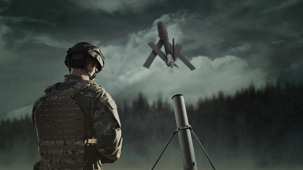
GHOST DRONES TO HELP UKRAINE
The United States has committed more than $4 billion in security assistance to Ukraine, including on April 21 more than 121 Phoenix Ghost tactical unmanned aerial systems. The drones were rapidly developed by the Air Force specifically to meet Ukraine’s requirements. The Ghost drones are manufactured by Aevex Aerospace and have similar capabilities to the single-use “kamikaze” Switchblade UAS from AeroVironment, which also are being provided to Ukraine forces. The Switchblade 600 shown here is designed to destroy tanks and other armored vehicles. It weighs slightly more than 120 pounds and has a range of more than 40 miles.
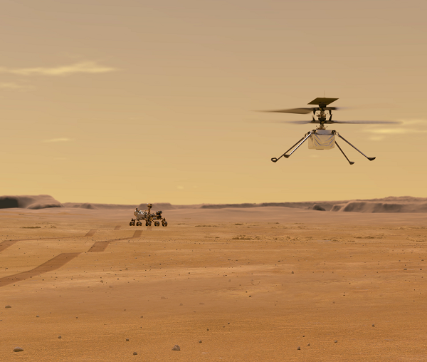
Photo: NASA/JPL-Caltech/University of Arizona/USGS
OUR MARTIAN ADVENTURE
NASA’s Ingenuity UAV has now spent more than a year on the surface of Mars, with 21 flights under its belt. It is now scouting potential routes for its companion, the Perseverence rover. Most recently, Ingenuity traveled to the Séítah region to examine an extinct river delta, covering 1,150 feet and navigating around a large hill, to help determine the best route into the delta. The NASA team continues to gently push the drone’s capabilities to better understand improvements that can be applied to future Mars UAV designs.
Russian jets using GPS receivers, while ground vehicles use paper maps
GPS receivers have been found taped to the dashboards of Russian jets downed in Ukraine, according to a report from Express. The Express received the information from Ben Wallace, United Kingdom defense secretary, who mentioned it in a speech at the National Army Museum.
The GPS receivers were found taped to the dashboards of Russian SU-34s because of “the poor quality of their own systems,” he said. It is unclear whether he was referring to the Russian GLONASS satellite navigation system or the navigation systems aboard the SU-34 jets, but most likely the latter. Lack of maintenance and modernization of Russian military equipment has been obvious since the beginning of Russia’s invasion of Ukraine.
As for navigation on the ground, many vehicles were found with paper maps from the 1980s, Wallace said.
Russian ground vehicles also lack situational awareness and digital battle management, he said, while the large amount of footage from Ukrainian drones points to a lack of wider air defense, including counter-UAV systems.
In a different news story from the war, Ukraine may be receiving Raytheon-built GPS-guided artillery rounds.
As PNT becomes critical to more economic activities, any disruption in availability, reliability, resilience and integrity would weaken the critical infrastructure that sustains national security, business operations and public safety, according to experts speaking at the Geospatial World Forum.
This growing dependency on PNT services — and the potentially high economic cost of vulnerabilities — underscores how vital GPS and GNSS systems are to the global economy and national security of countries worldwide, the experts said. Resilient PNT systems are necessary to combat GPS/GNSS outages.
Robert Cardillo (Photo: GWF)
Building resilience into these systems will require multiple technologies ranging from network time-transfer services to terrestrial wireless infrastructure and low-Earth-orbit (LEO) satellites.
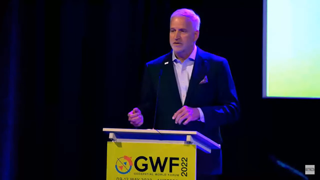
The Geospatial World Forum opened in Amsterdam on May 10. The second plenary of the day focused on the value of PNT in the global economy. Geospatial World is a global think tank working towards raising awareness around the use of geospatial data and technologies among governments and policymakers, businesses, and the public at large.
Robert Cardillo, president of The Cardillo Group and former director of the U.S. National Geospatial Intelligence Agency (NGA), headed the panel of experts.
“Our existence on this planet has been shaped by our individual and collective awareness of place and our confidence to be able to move securely and efficiently from one place to another, all within that common framework of position, navigation and timing, or PNT,” he said.
“The smartphone is a wonderful example of how far PNT has been integrated into our lives,” said Trimble founder Charlie Trimble. He laid down three basic phases involved in leading PNT to its place in the world economy.
“The path from the dawn of space age to the smartphone was anything but obvious or straightforward,” Trimble said. “First, Sputnik led to the global navigation systems. Second, the Shuttle disaster led us to the realization that the satellite system was an information utility. And now, the integration of PNT into the mobile and immobile internet is changing our world.”
From left: Charlie Trimble, Martin Sweeting, Rodrigo da Costa and Gillian Smith. (Photo: GWF)
“Our first contract was with ESA (European Space Agency) to look at the feasibility of using a navigation and timing satellite using small-satellite techniques, which in 1985 was considered a wacky idea,” recounted Martin Sweeting, executive chairman of Surrey Satellite Technology Ltd. “At ESA, we have embarked on a project called Hydro GNSS, which uses Surrey’s GNSS reflectometry to address several climate related issues, be it water detection or biomass, etc. This doesn’t stop here; we are looking at the lunar economy. PNT has indeed a very bright future, not just on Earth but also looking through this decade into the use of PNT on the lunar surface.”
Rodrigo da Costa
“New things are happening, particularly in the area of governmental satellite communications, space situational awareness and others, which are benefitting citizens every day,” said Rodrigo da Costa, executive director, EU Agency for the Space Programme (EUSPA). “Galileo, EGNOS (European Geostationary Navigation Overlay Service), Copernicus and GOVSATCOM programs are key areas of EU space activities. All these programs are massive investments and in the end, the result comes from their utilization in the different areas of our economy and daily life.”
“Just in the United States alone, GPS is approaching USD 1 trillion in terms of economic impact and is doubling every 2-3 years. But it is a single point of failure. This highlights the need for resilient PNT,” said Gillian Smith, vice president of marketing, NextNav. “We believe that our needs have evolved beyond technology that was really created in the ’60s. We need increased accuracy and availability in the urban environments in particular.
“I think many of you have experienced it if you’ve tried to use it in any major city,” Smith said. “That blue dot is going to bounce off of buildings and not be very accurate. We need indoor tracking and mapping. We need altitude data so that you know what floor you’re on when you’re thinking about accurate location. We also need to increase resilience and redundancy. That’s going to give us all increased security as well.”
The Value of GPS
GPS jamming and interference is a grave issue that has come under the spotlight particularly since the Russian invasion of Ukraine, according to Geospatial World.
In 2019, a Washington, D.C., think tank documented more than 10,000 cases of GPS interference (jamming and spoofing) in the previous five years from Russia. By 2021, these had become increasingly sophisticated. In a peculiar case, the crew onboard NATO ships in Odessa saw their position being given as Crimea.
In the past six months, even before the war on Ukraine began, there were reports of GPS jamming in and around that region. In March, the EU Aviation Safety Agency had issued warnings of GNSS spoofing and jamming for flights over Europe, in particular around countries neighboring Ukraine and Russia.
Globally, the economic impact of GPS/GNSS disruption is difficult to state. The potential economic consequences of failing to sufficiently protect sources of PNT are enormous, with estimates ranging from millions to billions of dollars depending on the type, length, severity and geographic scope of the disruption.
Furthermore, the impact of a GPS/GNSS outage extends beyond basic economics and could result in risk to life. Emergency services, distress beacons and telecommunications networks all rely on PNT services — any disruption could cause serious consequences.
A 2019 report sponsored by the National Institute of Standards and Technology estimated that the loss of GPS would cost the U.S. economy USD 1 billion a day.
A 2017 study in the United Kingdom estimated a five-day GNSS disruption would lead to an economic impact of GBP 5.2 billion (USD 7.2 billion), with road, maritime and emergency service impacts accounting for 88 percent of the cost.
Image: GPS World; outdoor, Andriy Solovyov/Shutterstock.com; indoor, Rade Kovac/Shutterstock.com
\Registration is now open for the fifth GNSS Raw Measurements Task Force meeting, which will take place on May 17. Participation is online, where participants will gain access to Task Force members’ experience and learn about progress on using raw measurements in Android devices.
The aim of the EUSPA’s Raw Measurements Task Force is to bridge the knowledge gap between raw measurement users. The meetings of the task force are a key element in this effort, providing a forum for stakeholders to share experience and knowledge around raw measurements use.
Following a welcome address from Fiammetta Dianithe, EUSPA’s head of Market, Downstream and Innovation (MADI) Department, the opening session will include a keynote presentation from Google`s Frank Van Diggelen and Mohammed Khider. Updates on EGNSS opportunities from the Galileo programme will be provided by members of the MADI team.
After the break, the agenda will be dedicated to presentations from Task Force members, targeting their innovative work using raw measurements. The last session focuses on testing results and implementation of EGNSS differentiators. For the full draft agenda, click here.
Since its launch in 2017, the task force has expanded from a handful of experts to a community of more than 100 agencies, universities, research institutes and companies. Membership is open to anybody interested in GNSS raw measurements. To join the task force, contact [email protected].
EUSPA’s mission is to link space to user needs. Over the past year, EUSPA has increased access to EU space data and services around the world, launched new Galileo satellites, and put in place additional satellite navigation services.
EUSPA operates Europe’s satellite navigation systems Galileo and EGNOS. It is also the gatekeeper to a secure EU Space Programme, providing end users with the confidence of knowing that the space-derived data they depend on is safe and secure.
The agency plays a central role in the market uptake of the data and services offered by the EU Space Programme components. EUSPA also manages the development of GOVSATCOM hubs, which will provide secure, cost-efficient communication capabilities to security and safety-critical governmental missions, operations and infrastructure.
the entry into service of a new Galileo satellite for additional accuracy to end-users
publishing the EO and GNSS Market Report, a comprehensive market intelligence study providing trends for the entrepreneurs and investors.
3.1 billion Galileo-enabled smartphones sold globally since 2016.
“I am more than proud of what EUSPA has achieved in a year. I am also proud to be at the helm of an organization staffed with dedicated professionals, with a service-oriented mindset who work to make EU Space accessible to citizens,’’ said Rodrigo da Costa, EUSPA executive director. “EUSPA remains committed to helping the union and its citizens maximize the socio-economic benefits of space.”
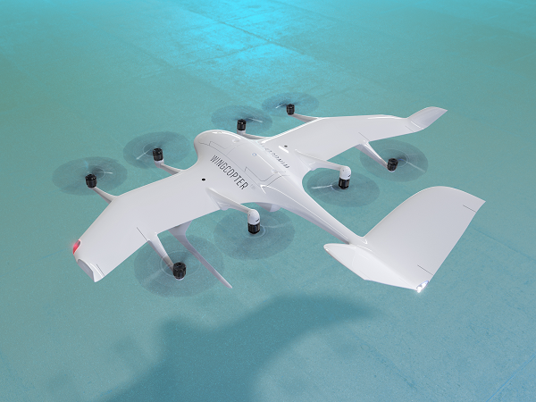
The U.S. Federal Aviation Administration (FAA) has issued the Special Class Airworthiness Criteria for the Wingcopter 198 U.S. unmanned aircraft. This approval marks a critical milestone in the certification process of Wingcopter’s flagship delivery drone in the United States.
Wingcopter is a German manufacturer of fixed-wing unmanned aircraft systems (UAS) and provider of drone delivery services, focused on optimizing medical supply chains, as well as last-mile logistics of packages, tools, spare parts, food, and groceries.
With the Airworthiness Criteria, the FAA defines technological requirements under title 14, Code of Federal Regulations (14 CFR), § 21.17(b) that must be met to have an aircraft type-certified for regular commercial operations in the United States.
The Wingcopter 198 is an electric vertical-takeoff-and-landing (eVTOL) drone engineered to meet stringent safety standards. In its development, Wingcopter was able to leverage the operational experience of more than five years with the company’s first delivery drone type in various geographical settings, from the Arctics to the Middle Eastern desert and from remote islands in the South Pacific to San Diego Bay in the United States.
Once type-certified, Wingcopter will be able to fly conventional routes through airspace and over populated areas, ultimately providing the basis for scaling commercial drone delivery operations across the United States that will help save and improve lives, the company said.
The certification is expected to have a positive impact on Wingcopter’s further certification efforts such as with the National Civil Aviation Agency (ANAC) in Brazil or the Japan Civil Aviation Bureau (JCAB).
Since applying for the Special Class Type Certificate in March 2020, Wingcopter has collaborated closely with the FAA. The issuance allows Wingcopter to focus its development efforts even more on what the FAA deems necessary for this particular aircraft to receive certification quickly and efficiently.
“We are proud to be among the first delivery drone companies worldwide to ever get their Airworthiness Criteria approved by the FAA,” said Tom Plümmer, co-founder and CEO of Wingcopter. “This is a very important milestone for us, not only in our Type Certification Process in the United States, but also for our international expansion efforts and for achieving our vision of building logistical highways in the sky. I would like to thank my team as well as the FAA for all the effort and great collaboration to reach this milestone.”
Vai Photonics was founded in Canberra in 2021 by physicists Lyle Roberts (left) and James Spollard to commercialize their research at Australian National University. ANU Vice Chancellor Brian Schmidt is at right. (Photo: Vai Photonics)
Advanced Navigation has acquired Vai Photonics, a spin-out from Australian National University (ANU) developing patented photonic sensors for precision navigation.
Vai Photonics’ vision, to provide technology to drive the autonomy revolution, is similar to Advanced Navigation’s. It will join Advanced Navigation in commercializing its research into autonomous and robotic applications across land, air, sea and space.
“The technology Vai Photonics is developing will be of huge importance to the emerging autonomy revolution,” said Xavier Orr, CEO and co-founder of Advanced Navigation. “The synergies, shared vision and collaborative potential we see between Vai Photonics and Advanced Navigation will enable us to be at the absolute forefront of robotic- and autonomy-driven technologies. Photonic technology will be critical to the overall success, safety and reliability of these new systems.”
James Spollard, CTO and co-founder of Vai Photonics, explained the technology. “Precision navigation when GPS is unavailable or unreliable is a major challenge in the development of autonomous systems. Our emerging photonic-sensing technology will enable positioning and navigation that is orders of magnitude more stable and precise than existing solutions in these environments. By combining laser interferometry and electro-optics with advanced signal-processing algorithms and real-time software, we can measure how fast a vehicle is moving in three dimensions. As a result, we can accurately measure how the vehicle is moving through the environment, and from this infer where the vehicle is located with great precision.”
The technology, in development for more than 15 years at ANU, will solve complex autonomy challenges across aerospace, automotive, weather and space exploration, as well as railways and logistics.
Aircraft with an electric vertical-takeoff-and-landing system such as flying taxis will greatly benefit from this technology, according to Advanced Navigation. Landing and takeoff are often considered the most dangerous and expensive part of a flight route. Vai Photonics sensors will provide safe and reliable autonomous takeoff and landings under all conditions.
Space travel and exploration is fraught with risks, vast complexity and enormous cost. This technology will bring massive benefits to space missions, helping to cement Advanced Navigation as the gold-standard for space-qualified navigation systems for space exploration.
“The work that underpins Vai Photonics’ advanced autonomous navigation systems stems from the search for elusive gravitational waves — ripples in space and time caused by massive cosmic events like black holes colliding,” said Brian Schmidt, vice-chancellor of ANU. “The team have built on a decade of research and development across advanced and ultra-precise laser measurements, digital signals and quantum optics to build their innovative navigation technology.”
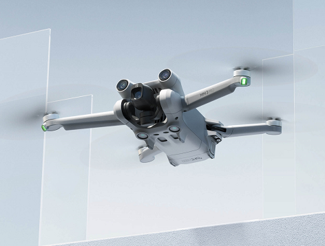
The DJI Mini 3 Pro is the high-end product of the DJI Mini series
DJI Mini 3 Pro. (Photo: DJI)
DJI has introduced the DJI Mini 3 Pro, its most powerful lightweight and portable camera drone. Weighing less than 249 grams — making it policy-friendly in many regions and countries — it delivers advanced features such as 4K/60 fps video, ActiveTrack, tri-directional obstacle sensing, and 90° gimbal rotation to shoot high-quality vertical imaging for social media. Its flight time extends past 30 minutes.
According to the regulations of many countries and regions, drones under 250 grams have been placed in the safest drone category. At under 249 grams, Mini 3 Pro’s weight, safety and performance is a new resource for content creators and new pilots.
Like its predecessors — Mavic Mini, Mini 2 and Mini SE — the Mini 3 can be folded for packing. Built-in features include enhanced flight performance, camera system, battery life and intelligent features previously available only in the Air and Mavic series.
New structural design. The arms and propellers have been adjusted for more aerodynamic flight, increasing flight time. Forward and backward dual-vision sensors broaden the sensing range for safer flight. A complete gimbal redesign unlocks more camera angles, enabling movements such as tilt-up shots and vertical shooting.
The Mini 3 Pro features tri-directional obstacle sensing, consisting of forward, backward and downward visual sensors. The forward and downward sensors have a wider field of view, providing seamless coverage for better route planning and environmental awareness. These sensors also enable Advanced Pilot Assistance System (APAS) 4.0, which automatically detects and finds a safer path around obstacles during flight.
In addition, these sensors enable the FocusTrack suite, which allows users to select a subject that the drone automatically keeps within the center of the frame during flight while automatically planning a safe flight route.