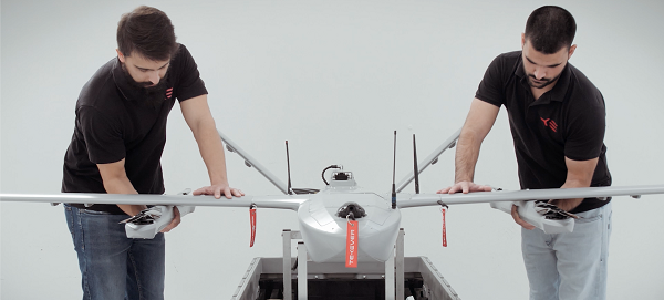
The AR3 maritime surveillance drone, usually launched horizontally, can be launched vertically with attachable propellers. (Photo Tekever)
Tekever, a European maritime surveillance provider, has unveiled a new version of its AR3 unmanned aerial system (UAS). The AR3 now has a “hot-swappable” vertical-takeoff-and-landing (VTOL) capability, able to switch from horizontal launch to vertical. It also now has integrated synthetic aperture radar (SAR).
Tekever made the announcement at AUVSI Xponential 2022 in Orlando, Florida. The company specializes in maritime surveillance services that deliver actionable real-time intelligence. The AR3 is a shipborne UAS designed to support multiple types of maritime and land-based missions up to 16 hours. With the upgrade, the AR3 becomes more operationally flexible, the company said.
“Users no longer have to choose between having pure fixed-wing assets for longer endurance missions, or fixed-wing VTOL assets for more challenging deployment conditions,” explained Ricardo Mendes, Tekever CEO. “The AR3 combines both capabilities and provides users with the ability to decide the configuration just moments before takeoff.”
The newly added SAR provides the AR3 with a vastly greater operational range, and the ability to effectively detect, recognize and identify targets under any weather condition. Covering more than 20,000 square nautical miles per mission, the new AR3 is the suitable for wide-area surveillance missions.
“Our SAR, which we named Gamasar in honor of the Portuguese navigator Vasco da Gama, is designed and built by Tekever specifically to provide our customers with capabilities that are typically only available through much larger systems,” Mendes said. “With an extremely reduced logistics footprint, the unprecedented VTOL flexibility and the unique capabilities provided by Gamasar, the new AR3 is a game changer that provides our customers with tremendous value and cost effectiveness.”
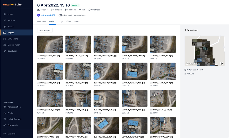
Auterion has introduced new capabilities for high-precision mapping missions and automated, end-to-end data workflows to make mapping more efficient, reliable and powerful across industries.
Unveiled at AUVSI Xponential 2022, updates to the Auterion OS serve enterprises with diverse use cases that need component and payload flexibility, alongside a centralized and streamlined software workflow.
Advantages for customers include:
Availability of precise mapping data in real time and automated processing that enables fast decision-making, saving time, ensuring consistency and reducing human errors.
Standardized process across any Auterion-powered vehicles, bringing an improved user experience, reducing training time, and affording easy scaling of operations.
Connectivity that enables automated end-to-end workflows with no need for manual data transfer, and integration with third-party data-processing software such as Esri Site Scan or Propeller.
“The mapping and workflow features included in this latest release of Auterion’s software focus on use cases from our enterprise customers,” said Markus Achtelik, vice president of engineering at Auterion. “We’re making sure that workflows are thoughtfully designed to meet customer needs and that the data they require is collected, automatically processed and streamlined through Auterion’s software platform for immediate use and longer term analysis.”
Auterion’s new platform capabilities are achieved through the enhancement of tightly integrated components. For example, the ground control app provides precise mission execution with fully integrated control of payloads, such as the Sony α7R IV camera. Then, capture and storage of geotagged images on the drone occur in real time.
Next, image data correction and processing happen seamlessly. This kind of automated workflow illustrates Auterion’s commitment to building efficient operational solutions for enterprise-ready drones, the company said.
“Auterion’s software is updated with its expanding open ecosystem in mind,” added Achtelik. “That gives customers the best options on the market, offering greater flexibility and choice to meet enterprise quality, scale, and regulatory needs.”
Juniper Systems has introduced the Geode GNS3 GNSS receiver, which allows users to collect real-time GNSS data with sub-meter, sub-foot and decimeter accuracy options.
With a scalable platform, users can purchase the level of accuracy they need now, while having the option to increase accuracy in the future.
“This new Geode offers expanded accuracy options to our users,” said John Florio, Geode product manager at Juniper Systems. “We set out to deliver a product that is scalable to our user’s needs. The GNS3 allows users to purchase a receiver that fits their accuracy needs at the moment, while still being able to unlock greater accuracy through subscriptions when that need arises.”
Photo: Juniper Systems
Available in both single-frequency and upgradable multi-frequency antenna configurations, users have the level of accuracy needed to get the job done. The Geode GNS3S offers superb sub-meter accuracy with a single-frequency antenna. The GNS3M allows for scalable accuracy; its multi-frequency antenna support all constellations on L1, L2 and L5 frequencies.
Multi-frequency signal tracking, together with Atlas L-band correction subscriptions, allow for up to decimeter accuracy. As with previous Geode devices, SBAS corrections are available for sub-meter accuracy in certain regions.
Both models also support local differential GNSS real-time kinematic (RTK) and continuously operating reference networks (CORS) through the Geode Connect NTRIP client.
“Providing Atlas corrections and scalable accuracy allows for the Geode to be used in new markets,” Florio said. “A few of these include water utility locating, agriculture and irrigation mapping, mapping projects in remote locations where other correction services are not available, and any other mapping need that requires a higher degree of accuracy.”
The Geode GNS3 offers flexible connectivity and can be used with Windows, Android, iPhone and iPad devices. A USB-C port allows for data transfer and fast charging and an antenna port allows for the use of an external antenna.
The Geode GNS3 GNSS receiver is now available worldwide.
Winners will present their projects at ION GNSS+ 2022 in Denver
The Institute of Navigation’s Satellite Division, in partnership with Google, will host the 2nd annual Smartphone Decimeter Challenge, with the winning teams presenting their methods at the ION GNSS+ 2022 meeting. ION GNSS+ 2022 takes place Sept. 19–23 at the Hyatt Regency Denver, adjacent to the Colorado Convention Centerx.
The Smartphone Decimeter Challenge is designed to advance research in smartphone GNSS positioning accuracy using state-of-the-art algorithms and technologies such as advanced machine learning models and precision GNSS algorithms.
While standard receivers using signals from GPS, other GNSS (Galileo, BeiDou, GLONASS) and regional systems (QZSS and IRNSS) provide accuracy between 3 and 10 meters (often worse in urban environments), better location can be obtained by processing carrier-phase measurements, inertial measurement unit (IMU) data, and base station corrections.
Teams will use datasets collected using the GPS receivers and IMUs of Android smartphones to compute location down to an accuracy of decimeters. Mobile users will benefit from lane-level-accuracy-based services, enhanced experience in location-based gaming, and greater specificity in location of road safety issues.
Winner selection is based on the accuracy of results from the test datasets compared to highly accurate ground truth. The top three winners will receive prizes valued at $15,000+ including a guaranteed speaking slot at the highly competitive ION GNSS+ 2022 conference (subject to technical paper and ION presentation requirements); a travel subsidy; and complimentary registration to attend ION GNSS+ 2022 in Denver.
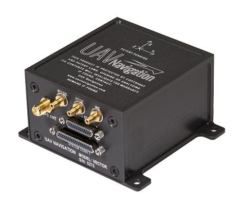
UAV Navigation has confirmed the safety and reliability of its Vector-600 autopilot for civil applications with an independent study. The study was performed as part of the European Union VaNeT project, and conducted by third-party company Anzen Engineering.
An autopilot system in an unmanned aerial vehicle (UAV) is the heart of the flight control system. For the Vector-600, the study included a reliability prediction report (RPR), failure mode effects and criticality analysis (FMECA) and fault tree analysis (FTA).
Reliability Prediction Report. The RPR analyzes probability of failure of every single sensor and component inside a system. It helps define component failure rates and, consequently, a prediction of the time that the VECTOR-600 is expected to operate free of failures under given operating conditions. According to this, the VECTOR-600 has shown a mean time between failures of more than 19,500 hours.
Failure Mode Effects and Criticality Analysis. A FMECA study identifies potential failures of system functions and assesses their effects, so that mitigation actions can be defined. It is a bottom-up analysis considering each single elementary failure mode and assessing its effects.
Fault Tree Analysis. Fault trees are a classic deductive analysis technique useful for both qualitative and quantitative analysis. For the Vector-600, a quantitative FTA provided probability estimates for major hazards, as well as identifying single-point failure modes and guiding further design for hazard reduction. According to the results, Vector-600 showed a probability of loss of mission per flight hour of 1,809E-05 under its operating conditions.
“The FMECA, RPR, and FTA analysis performed by the external and independent company Anzen have proven that our most advanced autopilot, Vector-600, is one of the most reliable GNC [guidance, navigation and control] systems for NATO Class I and II unmanned aircrafts available in the market and enables our clients to execute missions ensuring safety,” UAV Navigation stated in a press release.
The EU regulation framework defines three classes of operations: open, specific and certified. In specific and certified category operations, including most professional UAS flights, operators and aircraft manufacturers need to prove safe operation of their platforms. For this reason, the study of the reliability of the systems involved in the UAV becomes a must to demonstrate the system can operate free of failures under specific operational conditions.
The Open PNT Industry Alliance (OPIA) issued a statement regarding the recently approved U.S. Fiscal Year 2022 Appropriations Act. The alliance advocates for support of alternative positioning, navigation and timing (PNT) services.
In its statement, the 21 corporate members express support for the funding provided to the Department of Transportation to pursue alternative forms of PNT.
The OPIA also highlights a change to the National Timing Resilience and Security Act that eliminates the “land-based” technology requirement. The consensus among members is that the adjustment was needed so that the law would allow for multiple forms of PNT, a concept that aligns with the diverse technology principles of the coalition.
The Consolidated Appropriations Act for Fiscal Year 2022 (H.R. 2471) promotes robust positioning, navigation, and timing (PNT) technologies and preserves competition that drives innovation in the market.
Important Funding for PNT Services
The FY 2022 Appropriations Act, passed by the U.S. Congress and signed into law by President Biden on March 15, 2022, provides $15 million for the U.S. Department of Transportation (U.S. DOT) to establish a program that will support the U.S. government’s pursuit of many types of alternative PNT. The legislation aligns with U.S. DOT’s January 2021 “Complementary PNT and GPS Backup Technologies Demonstration Report” and summarizes how the funding will be applied.
OPIA encourages U.S. DOT to apply this funding to procure alternative PNT services and supplementary solutions that will protect critical infrastructure. Our members are prepared to engage civil government officials and critical infrastructure owners and operators to match needs with solutions.
Critical Change to Existing PNT Law
The National Timing Resilience and Security Act of 2018 (NTRSA) focused attention on the need to reinforce GPS. Congress subsequently recognized that NTRSA would be harmful to the commercial PNT market. The FY 2022 Appropriations Act revises the NTRSA to align with the U.S. DOT’s 2021 report that “the best strategy for achieving resilient PNT service is to pursue multiple technologies to promote diversity in the PNT functions that support transportation and other critical infrastructure sectors.”
This straightforward change to the NTRSA is as follows:
“Section 312(a) of title 49 United States Code, shall be amended by striking ‘land-based,’ after ‘operation of a’.” When the revised objective of the NTRSA is read in context, it is evident that the law is now fully inclusive of multiple forms of alternative PNT:
Subject to the availability of appropriations, the Secretary of Transportation shall provide for the establishment, sustainment, and operation of a land-based, resilient, and reliable alternative timing system (1) to reduce critical dependencies and provide a complement to and backup for the timing component of the Global Positioning System (referred to in this section as “GPS”); and (2) to ensure the availability of uncorrupted and non-degraded timing signals for military and civilian users in the event that GPS timing signals are corrupted, degraded, unreliable, or otherwise unavailable.
This move by Congress comports with the findings of the U.S. DOT’s report on PNT which state that “suitable and mature technologies are available in the private sector and offer owners and operators of critical infrastructure a diverse array of complementary PNT services to meet their GPS backup needs. Because such needs are application-specific, GPS resilience across all critical infrastructure sectors will require a plurality of diverse PNT technologies to meet multiple use cases.”
The commonsense modification to the NTRSA allows multiple alternatives to GPS and other global navigation satellite systems (GNSS) to deliver against a complex and ever-expanding set of institutional and end-user requirements.
The alignment with OPIA’s bedrock principles is clear:
A diverse technological landscape offers varied operational characteristics to support all critical infrastructure sectors.
True resilience requires diversity that a sole-source technology cannot meet in terms of reliability, performance, and the flexibility to address evolving attack prevention and threat response needs.
The ingenuity of the private sector marketplace will drive the emergence of multiple cost-effective GPS/GNSS alternatives that evolve according to technological innovations and market dynamics.
Open PNT Industry Alliance members provide what critical infrastructure needs for resilience: alternative forms of PNT that complement GPS/GNSS as well as augmentation services, security solutions, and hardware/software for time synchronization, navigation and location applications.
Beluga is a new generation of small unmanned aerial systems (sUAS), the result of three years of design and development. The Beluga sUAS is designed to perform a wide variety of tasks including medical transportation, precision farming, search and rescue, and last-mile delivery.
The system will include the uAvionix George G3, a CubePilot-based autopilot designed to DAL-C safety standards, and the truFYX EXT GPS which provides high-quality avionics at low size, weight and power consumption (SWaP) at a low cost. Beluga will soon include the ability to operate on skyLink C-band CNPC radios, fully integrated with George.
The George ecosystem includes a microLink radio, a truFYX GPS receiver and the George autopilot. (Photo: uAvionix)
Spirent is one of only 226 organizations in the United Kingdom to be recognized with the Queen’s Award, which acknowledges the company’s excellence in international trade.
Spirent is headquartered in the UK, with its positioning business in Paignton, Devon, developing and manufacturing positioning, navigation and timing (PNT) test solutions. It also has a research and development facility in Daventry, Northamptonshire.
“As reliance on PNT technology continues to grow, our positioning technology business is the trusted partner of the world’s foremost PNT developers, delivering maximum performance without compromise through our dedicated test and validation solutions,” said Martin Foulger, general manager, Spirent Positioning. “We are honored to receive the prestigious Queen’s Award accolade, which is testament to the hard work of our employees in enabling us to achieve such tremendous success worldwide.”
Powered by its international trade, its exports outside of the UK represent a significant proportion of its business, serving a global customer base across five continents and more than 40 countries. Its technology has represented the global gold standard for commercial and government research and development facilities since the inception of GPS.
Its core business is the simulation of GNSS signals in laboratories for the development of applications used in advanced aircraft, chipsets, satellites, smartphones, cars, autonomous systems, marine vessels and defense systems, as well as the navigation systems themselves.
“Market leaders who are developing PNT applications have placed their trust in our test solutions for decades due to our unrivaled performance, realism and reliability,” said Foulger. “Furthermore, Spirent expertise is directly enabling and driving innovation in connected and autonomous vehicles and machine learning, as well as helping to make the world more sustainable through working closely with fields such as smart cities and precision agriculture.”
Now in its 56th year, the Queen’s Award are the most prestigious awards for businesses in the UK and a globally recognized royal seal of approval for companies. As a winner of the award, Spirent is permitted to display the esteemed Queen’s Awards Emblem for the next five years.
The following op-ed was released by U.S. representatives Don Bacon and Mikie Sherrill, co-chairs of the congressional Global Positioning System Caucus.
The US military needs a modernized GPS capability to maintain superiority
By Rep. Don Bacon and Rep. Mikie Sherrill
Don Bacon
In December 1993, the U.S. declared that the satellites comprising the Global Positioning System constellation had achieved initial operational capability, representing the culmination of a 20-year effort to develop and launch the first global navigation satellite system.
GPS, which began as a U.S. government project to provide positioning, navigation and timing information by broadcasting radio signals from satellites to the ground, stands alone in the revolutionary impact it has had on both our warfare abilities and our commercial industries. However, an aging constellation and unyielding international competition has put America’s GPS superiority at risk.
“We believe it is critical to our international interests that the U.S. reinvest in GPS modernization. We cannot afford to overlook the satellites.”
Mikie Sherrill
In the decades since achieving initial operational capability, GPS has become integrated into virtually every facet of the U.S. economy and is part of everything from our cellphones to our financial, agricultural, transportation and manufacturing sectors — and to every aspect of our national security.
Even as GPS has grown to become a fundamental part of our everyday life, the U.S. provides GPS signals for free to users worldwide. And yet, China, Russia, the European Union, India, and Japan have all developed regional or global satellite systems since GPS was launched.
Most recently, China’s completion of its BeiDou system comprised of over 30 satellites — part of its broad Belt and Road Initiative — risks endangering U.S. technological leadership. Beijing has made it clear that it will leverage BeiDou as part of an overall strategic effort to obtain greater influence internationally, heavily subsidize the adoption of BeiDou-equipped infrastructure for government and military use in countries throughout its region, and advantage BeiDou-compatible domestic products.
As the House co-chairs of the congressional GPS Caucus, we believe it is critical to our international interests that the U.S. reinvest in GPS modernization. We cannot afford to overlook the satellites — the oldest of which were launched in the late 1990s or early 2000s — that underpin civil and social infrastructure, including civil aviation, banking systems, financial markets, power grids, precision agriculture, and communications networks and applications. Even as manufacturers develop multi-constellation devices that can receive signals from both GPS and other global systems, it is more critical than ever that the U.S. accelerate its investment in next-generation GPS satellites.
To that end, the U.S. has begun modernizing the GPS constellation, with significant technological benefits for U.S. warfighters and civil users. New GPS satellites provide three times greater accuracy, and eight times improved resistance to inference and signal blocking known as jamming. However, the replacement of outdated GPS satellites in the constellation has not kept pace with our international competition and emerging global threats.
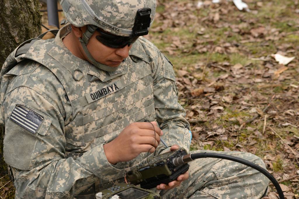
A U.S. paratrooper uses a Defense Advanced GPS Receiver during a live-fire exercise at Grafenwoehr, Germany. (Photo: Spc. Markus Rauchenberger/U.S. Army)
We believe that our efforts to invest in American technological leadership must include an increased launch rate of new GPS satellites with both crosslinks and on-orbit reprogrammable capabilities. Crosslinks enable greater accuracy, and on-orbit reprogrammability can counter jamming and spoofing by providing means to update signal and/or data streams and quickly counter emerging threats without the need to produce and launch new satellites.
A necessary and critical element of GPS modernization is also the development of a systematic road map for the use of our modernized GPS system by civil manufacturers and users across industries. Together, these steps will allow the United States to maintain its global leadership; enable U.S. firms to continue to offer innovative GPS-based products and services; and counter efforts by our international adversaries to give preference to their own technologies.
As the first and unrivaled provider of space-based services to the public, GPS currently provides $1 billion in economic impact from the U.S. civil GPS sector every day. As we move to a multi-constellation world, it is more critical than ever that the U.S. accelerates investment in our GPS enterprise to enable the next-generation benefits that a modernized constellation will bring to our warfighter, the U.S. economy and the free nations of the world.
Rep. Don Bacon, R-Neb., is a member of the House Armed Services Committee and a co-chair of the congressional Global Positioning System Caucus. He retired from the U.S. Air Force as a brigadier general.
Rep. Mikie Sherrill, D-N.J., serves on the House Armed Services Committee and is a co-chair of the congressional Global Positioning System Caucus. She served in the U.S. Navy for nearly a decade as a helicopter pilot and Russian policy officer.
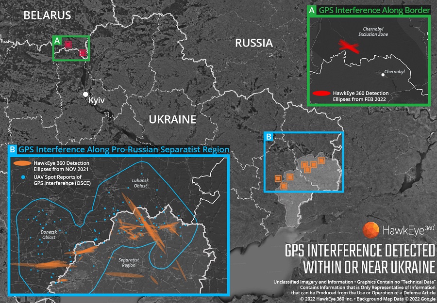
Technology from HawkEye 360 Inc. has detected and geolocated extensive GPS interference over Ukraine, starting months before the Russian invasion. HawkEye 360 uses satellites to monitor radio-frequency signals that might threaten military and civil navigation applications.
The capability was tested in 2021 in a variety of exercises and is available as part of HawkEye 360’s RFGeo signal product catalog.
When HawkEye 360 analysts examined Ukraine over the past five months, they discovered continued and increased GPS interference across the region. The data showed extensive GPS interference in November 2021 along the boundary of the pro-Russian separatist-controlled regions in Luhansk and Donetsk.
Open-source information confirmed unmanned aerial vehicles (UAVs) operating in the area were disrupted because of lost GPS connections.
In February 2022, HawkEye 360 detected GPS interference along the border between Ukraine and Belarus, shortly before the Russian invasion started. This February activity occurred north of Chernobyl within the Chernobyl Exclusion Zone, demonstrating the integration of electronic warfare tactics into Russian military operation to further degrade Ukraine’s ability for self-defense.
“GPS is a fundamental ‘global commons’ service that all modern economies depend upon. GPS signal interference has the potential to significantly disrupt air travel, logistics, finance, transportation, communication and many other basic services,” said John Serafini, CEO of HawkEye 360.
“Whether unintentional or deliberate, interference that prevents people, vehicles, ships, and planes from determining accurate locations can be devastating to government and commercial activities alike,” Serafini said. “Since HawkEye 360 can monitor hundreds of millions of square kilometers daily, we are able to notify clients when and where GPS interference occurs, so they can respond quickly to mitigate the impacts.”
Interference can be inadvertent by equipment operating too close to GPS frequency bands. However, deliberate interference has spiked across the globe due to the low cost, ease of deployment, and general availability of GPS jamming technology.
Military forces use GPS jammers to obscure and protect critical troops, facilities and equipment from attack and can be a leading indicator of future military activity. Drug cartels use GPS jammers to deter surveillance from overhead drones. Use of jammers is illegal in most developed nations.
HawkEye 360’s detection product offers a valuable capability to monitor for illicit and unintentional GPS interference that can significantly disrupt critical location services, representing the company’s global commitment to make the world a safer place, the company said.
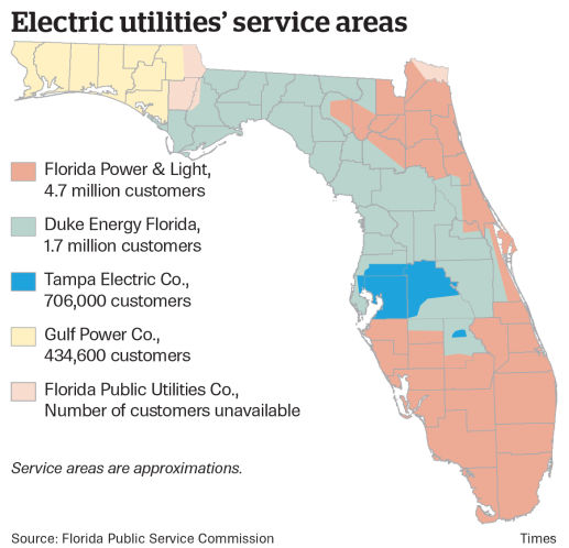
Florida Power & Light to deploy 13 autonomous drones, with plans for hundreds more in coming years to monitor statewide power grid
UAV company Percepto will deploy autonomous drones to monitor Florida power substations and distribution grids across the state.
Florida Power & Light (FPL) will deploy drone-in-a-box technology statewide, which Percepto claims is the largest commercial autonomous drone project in the world.
FPL serves the northeast and southern half of Florida. (Image: Florida Public Service Commission)
Serving more than 11 million people in Florida, FPL uses Percepto’s Autonomous Inspection and Monitoring (AIM) solution powered by drones to perform routine infrastructure inspection and monitoring.
In the first phase of the project, 13 drones will take flight in the West Palm Beach area this year, with long-term plans to field hundreds of Percepto over the next five years.
The drone-in-a-box solution was the first to pass Level 5 hurricane testing at a wind speed of up to 155 mph, making it suitable for minimizing incident response times and power outages in Florida.
Percepto has served FPL since 2018, working closely to develop optimized drone monitoring solutions and build consensus and compliance with Federal Aviation Administration (FAA) regulations. The FAA issued a nationwide waiver for FPL to fly Percepto drones for surveillance and inspection purposes at sites owned and serviced by FPL.
As part of its ongoing work with the FAA, Percepto is a member of the Beyond Visual Line of Sight (BVLOS) Aviation Rulemaking Committee (ARC) that has provided its regulatory recommendations to fully incorporate highly automated BVLOS operations flights in the national airspace.
The drones in operation across the state will be coordinated on a single platform through Percepto’s AIM solution. With Percepto AIM, drones can be operated remotely to ensure that they work together in sync, providing maximum coverage at the sites they monitor.
Topcon Positioning Group has announced a new option for Caterpillar Next Gen excavator users to leverage Topcon 3D machine control functionality together with Cat Assist features. As a result of new compatibility of the Topcon 3D Excavator System with Caterpillar factory-installed NGH sensors, customers will experience simplified installation of the Topcon aftermarket system into Caterpillar’s existing 2D excavator systems, in coordination with Topcon and Caterpillar dealers.
“With increased pressure for productivity and accuracy, and the industry’s need for skilled operators, the solution is timely,” said Jamie Williamson, Topcon executive vice president. “The customer will have the benefit of Topcon 3D Excavator System and Caterpillar Assist features working together. Once the user is acquainted with the combined system, it will be easy to be a more productive operator.”
The Topcon system is designed to provide real-time, dynamic, on-screen bucket location and design views, resulting in the operator cutting grade faster and more accurately. The operator can create, cut and check designs directly from the cab. Together with Caterpillar boom and bucket automation, operators can deliver quality work all day long with less fatigue, according to Topcon.