A roundup of recent products in the GNSS and inertial positioning industry from the August 2021 issue of GPS World magazine.
OEM
GNSS board
Photo: Javad GNSS
With GLONASS dynamic calibration
The TRE-3S GNSS board measures 100 x 80 mm, weighs 87 g and tracks 874 channels with all-in-view satellite tracking. It includes numerous features to protect against interference and improve signal output: spectrum data output, spoofing detection, advanced multipath reduction, in-band interference rejection, GLONASS 0.2-mm dynamic calibration, heading determination, attitude determination and fast acquisition channels. The TRE-3S receives GPS L1/L2/L2C/L5; Galileo E1/E5A/E5B/AltBoc/E6; GLONASS L1/L2/L3; BeiDou B1/B1C/B2/B3; QZSS L1/L2/L5/L6 (L61/L62); and SBAS L1/L5. It has a 20-Hz update and real-time kinematic (RTK) rate for real-time positioning and raw data (code and carrier). Optional features include tracking QZSS L6 (LEX) and IRNSS L5/S-band, and a data update rate and RTK rate of 100 Hz.
For high-precision applications with L-band corrections
Photo: Maxtena
The M9HCT-A-SMA is a patented helix antenna for GNSS plus L-band corrections services, suitable for high-precision and autonomous multi-frequency applications. It provides simultaneous GNSS reception in a rugged, compact form factor. The M9HCT-A-SMA is suitable for high-precision applications such as the UAV market, where high performance and low weight are driving features in antenna selection. The active helix design features Maxtena’s patented compact and lightweight Helicore technology, which provides excellent pattern control, polarization purity and high efficiency in a compact form factor.
New eXtended Filtering (XF) is now employed in the TW3900 series of Accuntena precision antennas. The XF feature mitigates interference from all near-band signals and ensures the antenna provides the purest possible GNSS signals. The custom XF filtering has been tested to mitigate new (in Europe and Japan) and existing LTE signals, enabling the XF antennas to produce clean and pure GNSS radio frequency data. The XF models are TW3972XF, TW3972EXF, TW3972LGXF, TW3967XF and TW3967LGXF. All are triple-band antennas that support GPS/QZSS (L1/L2/L5), GLONASS (G1/G2/G3), Galileo (E1/E5ab), BeiDou (B1/B2/B2a), NavIC L5 and L-band correction services.
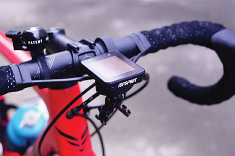
The iGS320 cycling computer builds on the u-blox M10 positioning platform, leveraging the M10’s ultra-low power consumption, compact size, and ability to track all four GNSS to offer endurance athletes a superior user experience. Adopting the M10 in its iGS320 cycling computer brought iGPSPORT an 80 percent increase in the power autonomy to deliver 72 hours of continuous tracking, up from 40 hours in their previous device. Concurrent reception of up to four GNSS constellations increases coverage and accuracy in otherwise challenging signal environments.
The Beamo 3D mapping platform enables surveyors to scan a project site and immediately collaborate with teams in the field without lengthy delays or cumbersome equipment. The digital twin created in the platform provides a single and secure source of truth for teams without requiring highly technical knowledge. With a 360-degree camera, surveyor teams can create detailed digital environments that remote teams can use to track progress, collaborate with coworkers, and take accurate measurements without having to physically visit the site.
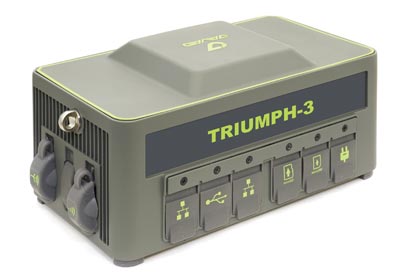
The Triumph-3 receiver tracks efficiently even in difficult conditions. It can track all current signals and is ready for future satellites. The Triumph-3 can operate as a base together with Triumph-LS and Triumph-LS Plus to efficiently accomplish any geodetic job. Its RTK system communicates via integrated UHF, 4G/LTE, Wi-Fi and Bluetooth channels, and eliminates the need to subscribe to a real-time network for corrections. A powerful and reliable receiver for high-precision navigation systems, the Triumph-3 is based on the Javad GNSS 874-channel chip. It is equipped with an internal 4G/LTE/3G card and secure and accessible microSD and microSIM cards. It also supports Javad’s lift-and-tilt technology.
Eos Bridge enables almost any instrument to become iOS Bluetooth compatible. The pocket-sized device connects to instruments via Bluetooth Classic or serial port, and then transmits data to any Apple iOS device, such as iPhone or iPad, Android device or Windows mobile device. Instruments equipped with non-iOS Bluetooth can connect to Apple iOS devices using the Eos Bridge, including laser rangefinders and utility-locating instruments. Instruments whose only connectivity option is a serial port also can connect, such as any instrument or sensor with an RS-232 serial port. The Eos Bridge is lightweight, at approximately 150 grams (about 5.3 ounces). It can be worn clipped to a belt, stored in a pocket, or mounted to an instrument or sensor. The battery lasts 48 to 72 hours.
The OceanReports web tool provides users with specialized “ocean neighborhood analyses,” including maps and graphics, by analyzing more than 100 ocean datasets instantaneously. Reporting data includes information about habitats and species, industries in the area, potential hazards (such as undersea cables or shipwrecks), the economic value of ocean commerce, and other detailed oceanographic information. The web-based interactive tool for ocean mapping and planning, created by the National Oceanic and Atmospheric Administration (NOAA) and the Department of the Interior’s Bureau of Ocean Energy Management, provides professional users and the general public with opportunities to explore the ocean from their own computer.
HxGN Mass Transit is a geospatial transportation infrastructure management system with 3D and AI capabilities for visualizing and analyzing transit and rail assets and operations. Built on Hexagon’s M.App Enterprise, HxGN Mass Transit provides an advanced digital twin of a city’s entire public transportation network — including tracks, stops, switches, construction sites, ticket machines, benches and garbage cans. It integrates asset and spatial data so operators can visualize and analyze an entire network with accurate and up-to-date information.
The GAJT-410MS provides anti-jamming to marine vessels. (Image: NovAtel)
The GAJT-410MS provides NovAtel’s GPS Anti-Jam Technology (GAJT) for the commercial and defense marine markets. The low SWaP variant protects civil and military operations from interference and jamming, with jammer direction-finding capabilities for enhanced situational awareness in the marine environment. The GAJT-410MS provides dynamic protection on both GPS L1 and L2 bands, as well as Galileo E1, QZSS L1 and L2, and SBAS L1 to combat intentional and unintentional interference.
The ACR 2830 GlobalFix V4 EPIRB marine distress beacon has multiple built-in redundancies to increase chances of survival in an emergency situation. The internal GPS receiver pinpoints the user’s location, which is then transmitted on the 406-MHz distress signal. In the absence of GPS-derived coordinates, the signal can be used to triangulate the position. The beacon’s 121.5 MHz homing signal will bring local search-and-rescue forces directly to the position; an LED strobe light allows them to see the position in low light. A Category 1 Emergency Position Indicating Radio Beacon (EPIRB), the GlobalFix V4 is a float-free device that will automatically activate when submerged in water. Two self-tests monitor transmission, power and battery performance as well as GPS acquisition.
A new connected platform for rail passengers with Wi-Fi, information and entertainment content is being installed on OUIGO Spain trains through the OUIFUN portal. Passengers can connect via smartphones, tablets or PCs, access the internet on board to check email or browse the web, and enjoy entertainment content. Passengers also will be able to get travel status information in real time via an interactive map, access tourist guides or consult a menu for on-board catering. The service, provided by Moment, launched on May 10 on OUIGO’s first high-speed line in Spain connecting Madrid to Barcelona, and will gradually be extended to the whole high-speed OUIGO network.
The ANAFI Ai UAV uses 4G as its main data link between the drone and the operator. The 4G link improves data transmission and enables precise control at any distance. For BVLOS flights, it stays connected even behind obstacles. The 4G link between the drone and the user’s phone is encrypted, with a secure element protecting both software integrity and data privacy. A software development kit enables creation of custom code for flights and gives access to all sensors, including obstacle-avoidance sensors, occupancy grid and internet access.
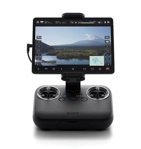
An introductory model in Sony’s new Airpeak line, the small S1 drone can be equipped with the company’s full-size mirrorless interchangeable-lens Alpha camera. Its proprietary motor, propeller, control system and sensing technology allow it to fly at high speed (a maximum speed of 55 mph) with stable wind resistance. Propulsion technology using a combination of devices developed by Sony provides wind resistance in strong wind speeds up to 44.7 mph. The Airpeak S1 includes obstacle detection, automatic flight control via sensing, and increased safety via cloud management of the aircraft.
At 80 grams, George is a low SWaP certifiable solution for enterprise operations and those wishing to type certify their UAS. Built around the open-source autopilot Cube from CubePilot, George combines Cube with Design Assurance Level C (DAL-C) hardware and safety and sensor monitoring, enabling customers to meet the type certification and safety case requirements for BVLOS operations. Its triple-redundant IMU includes three accelerometers, three gyroscopes, three magnetometers and three barometers. The hardware platform is designed and built to RTCA DO-254 DAL-C and meets rigorous DO-160G and MIL-810H power and environmental qualifications.
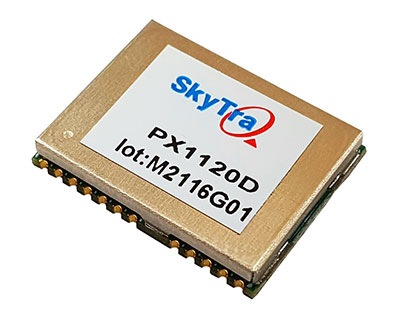
SkyTraq Technology Inc. has launched a GNSS/inertial measurement unit (IMU) suitable for both automotive pre-installation and aftermarket.
The robust PX1120D dead-reckoning module integrates a 6-axis IMU and a concurrent quad-GNSS chipset, forming a sensor-fusion solution that maximizes positioning accuracy even in challenging environments. The PX1120D receives concurrent GPS/GLONASS/Galileo/Beidou/QZSS signals.
For automotive pre-installation applications where vehicle wheel-tick signals are available, the PX1120D provides wheel-tick sensor fusion with automotive dead-reckoning. In aftermarket applications where wheel-tick signals are unavailable, the PX1120D provides an untethered dead-reckoning sensor-fusion solution.
A single PX1120D module provides both automotive and untethered dead-reckoning functionality, simplifying logistics. The PX1120D provides 100% position coverage. It is suitable for infotainment systems, telematics control units, vehicle tracking, and advanced driver-assistance systems (ADAS) applications that require the highest performance and reliability, as well as uninterrupted positioning.
The PX1120D supports flexible mounting in any orientation. Its auto-calibration feature simplifies the installation procedure.
The 12 x 16 mm PX1120D offers continuous navigation in tunnels and underground parking lots. It can output attitude, gyroscope and accelerometer sensor data, making it useful for black-box driver behavior monitoring and insurance accident reconstruction.
The PX1120D uses an AEC-Q100 qualified chipset and is manufactured in ISO/TS-16949 certified plants. An engineering sample, evaluation kit and datasheet will be available by the end of August. Volume delivery to customers begins in the fourth quarter of this year.
The Qualcomm Flight RB5 5G platform accelerates and scales development for drone manufacturers to deliver powerful enterprise and industrial 5G drones
Qualcomm Technologies has unveiled a drone platform and reference design that offers both 5G and artificial intelligence capabilities.
The Qualcomm Flight RB5 5G platform is designed to accelerate development of commercial, enterprise and industrial drones. Powered by the Qualcomm QRB5165 processor, it builds upon Qualcomm Technologies’ latest offerings for the internet of things, delivering a solution that will drive the next generation of high-performance, low-power, 5G drones, the company said.
As a primary driver of global 5G proliferation, Qualcomm Technologies has enabled 5G to scale for both the drone and robotics industries. The new 5G platform condenses multiple complex technologies into a tightly integrated drone system. Use cases include mapping, inspection, film and entertainment, defense, security and emergency response, and delivery.
Photo: Qualcomm
The Qualcomm Flight RB5 5G Platform’s high-performance and heterogeneous computing at ultra-low power consumption provides power efficient inferencing at the edge for AI and machine learning (ML), enabling fully autonomous drones, the company said. New camera capabilities deliver premium image capabilities and performance.
With 5G and Wi-Fi 6 connectivity, this platform enhances critical flying abilities beyond visual line-of-sight (BVLOS) to support safer, more reliable flight. In addition, safety controls alone can no longer assure industrial and commercial drone safety, especially when scaling to Beyond Visual Line of Sight operations.
The Qualcomm Flight RB5 5G platform is equipped with a Qualcomm Secure Processing Unit to support modern drone demands for cybersecurity protections as a key enabler of data-protection and safety requirements.
Partners. Qualcomm Technologies is working with Verizon to complete network testing of the Qualcomm Flight RB5 5G Platform for the Verizon 5G network, and expects the platform, which is 5G mmWave capable, will be offered via the Verizon Thingspace Marketplace.
The Qualcomm Flight RB5 5G drone reference design is available now for pre-sale through ModalAI. A development kit is expected to be available this year in the fourth quarter.
“We have continued to engage many leading drone companies, enabling 200+ global robotics and drone ecosystem members in addition to consistently driving and promoting worldwide drone standardization and transformative 5G capabilities in organizations such as 3GPP, GSMA, the Global UTM Alliance, the Aerial Connectivity Joint Initiative (ACJA) and ASTM,” said Dev Singh, senior director, Qualcomm Technologies.
In addition, global carriers and IoT ecosystem who have validated or expressed support for the drone platform include Asia Pacific Telecom, AT&T, China Unicom, Everguard.ai, FlightOps, Juganu, KT Corporation, LG Uplus, MITRE, ModalAI, Taiwan Mobile, TDK, Veea, Verizon Skyward and Zyter.
“Seen & Heard” is a monthly feature of GPS World magazine, traveling the world to capture interesting and unusual news stories involving the GNSS/PNT industry.
Photo: IBM
Sailing new school
An autonomous ship designed to recreate the Mayflower’s historic journey across the Atlantic 400 years ago returned to the UK after developing a mechanical problem. IBM’s Mayflower Autonomous Ship (MAS) set sail on June 15 on its 3,500-mile journey from Plymouth in the UK to Massachusetts in the United States. The voyage is expected to take about three weeks, and includes collections of data on marine life and sampling for plastic waste. The 50-foot long, solar-powered trimaran is capable of speeds of up to 10 knots (18 km/h) and is being navigated by on-board artificial intelligence (AI) with information from six cameras and 50 sensors. Project leaders say the AI worked perfectly. The ship navigates with precision GNSS, inertial measurement units, radar, weather station, SATCOM and the automatic identification system.
Photo: Lt.j.g. Alexander Fairbanks/U.S. Navy
Sailing old school
U.S. Navy sailors aboard mine-countermeasures ship USS Patriot used celestial navigation to navigate an 1,100-mile voyage back to port on the western coast of Japan in July 2020. The voyage allowed the crew to improve their mariner skills as they used sextants to find their latitude and longitude and compasses to determine their heading. The exercise wasn’t entirely old school. The sailors entered the celestial measurements into a computer to pinpoint their position using the System to Estimate Latitude and Longitude Astronomically (STELLA). The combination of repeatedly inputting sextant measurements, the course and speed of the ship, and time into STELLA, provided an accurate fix of the ship’s position. For backup, Combat Information Center (CIC) watch standers followed the ship’s course with GPS. Training in celestial navigation returned to the Navy as a core competency in 2016, 17 years after the U.S. Naval Academy stopped requiring midshipmen to learn the technique.
Photo: Lt.j.g. Alexander Fairbanks/U.S. Navy
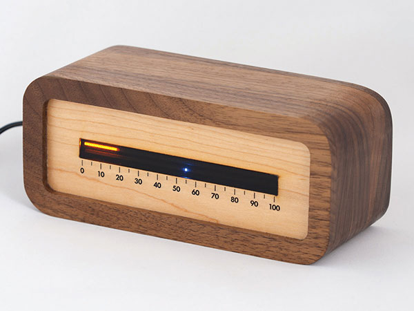
Linear clock shows sunrise, sunset
A creative technologist spent his COVID-19 downtime creating a device that uses a GNSS receiver to compute time relative to sunrise and sunset. “Since it derives time from the satellite signal, it never needs to be set, or ever adjusted for daylight saving time,” explains creator James Wilson on his webpage. The device uses satellite navigation and astronomy to show time as a progress bar measuring the percentage of the day elapsed since sunrise. A second indicator marks the time to sunset in blue.
Tracking Iran’s nuclear site
A team with Stanford University’s Center for International Security and Cooperation (CISAC) is keeping tabs on activity at Iran’s Natanz nuclear facility using BlackSky’s geospatial imagery and burst collection technology. BlackSky’s satellites provide intraday revisit capabilities, allowing CISAC’s research team to receive multiple images a day, throughout the day, rather than just one image collected at roughly the same time each day. The satellites also can capture a sequence of 20 images within minutes (burst collection) and splice them together to generate a moving sequence of activity. With BlackSky’s assistance, the research team was able to witness trucks emerging from the facility’s underground tunnels.
Catapult, a sports performance technology company, says that it helped athletes at the 2020 Olympic Games in Tokyo win 24 medals. Catapult athletes took part in rugby, football and rowing, representing various countries. Among athletes using Catapult were members of the Canadian women’s football team, who helped Canada win gold for the first time in the sport.
“We strive every day to find the improvements that unleash the full potential of all our athletes and teams, and we’re proud to see our customers’ hard work pay off on the world stage,” said Will Lopes, CEO of Catapult. “Following an unprecedented year of delayed and disrupted training, athletes were able to use our technology to continue to compete at the highest level and perform at their best.”
The athletes were wearing the Vector system, which provides data to aid decisions on performance, risk and return to play. The Vector GNSS/LPS device combines advanced GNSS capability with Catapult’s ClearSky LPS to deliver tracking data both indoors and outdoors.
The trial for the U.S. Department of Homeland Security showcases the precise, resilient timing capabilities of NextNav’s TerraPoiNT service in the event GPS is unavailable.
NextNav has successfully demonstrated the timing precision and resilience of its terrestrial positioning, navigation and timing (PNT) system, TerraPoiNT, in a recent evaluation by the Science and Technology Directorate of the Department of Homeland Security (DHS S&T).
The trial tested the timing redundancy of the TerraPoiNT system in a number of scenarios, including instances of GPS outages, spoofing and jamming. It validates TerraPoiNT’s capabilities as a terrestrial, GPS-free network capable of powering critical national infrastructure in the event of GPS failure.
During a simulated 72-hour GPS outage, the TerraPoiNT service was able to deliver a timing accuracy better than 50 nanosecond in urban and semi-urban environments, successfully meeting timing requirements for various applications including 5G networks, the synchronization of the power grid, and more.
In addition, TerraPoiNT provided precise timing and redundancy utilizing two alternate absolute timing sources — atomic clock (Cesium/Rb) and LEO satellite (Satelles).
“GPS is critical infrastructure, but it has its limitations,” said Ganesh Pattabiraman, co-founder and CEO of NextNav. “In working with DHS S&T, we’ve validated that TerraPoiNT can serve as an important backup to GPS and ensure the resilience and continuity of our nation’s most critical systems, including next-generation telecommunications networks, financial services, and power grids.”
Satelles STL
STL from Satelles was one of two alternate absolute timing sources for the trial. Available today on a global basis, STL is a service that provides alternative PNT independent of GPS, supporting PNT-reliant applications such as 5G communications networks, high-frequency trading in financial markets, and electrical grids throughout the United States and around the world.
“Satelles applauds NextNav for conducting a successful field demonstration of its resilient PNT service, and we were delighted to have played an instrumental part in the exhibition,” said Christina Riley, vice president of Commercial PNT.
NextNav’s selection of STL to help demonstrate their own technology’s operation in the absence of GPS was a natural fit. That’s because earlier this year the U.S. National Institute of Standards and Technology (NIST) confirmed STL as an accurate and reliable source for the wide-area delivery of Coordinated Universal Time independent of GPS/GNSS.
Previous TerraPoiNT evaluations
The successful trial builds on recent evaluations of TerraPoiNT conducted by independent bodies. Earlier this year, the Department of Transportation (DOT) evaluated 11 alternate PNT solutions, in which each was rigorously tested across applications and scenarios. As a result of the evaluation, the DOT named TerraPoiNT the best and only performing solution across all PNT categories.
Spartacus. In June, NextNav entered into a definitive merger agreement with Spartacus Acquisition Corporation in a transaction that would result in NextNav being listed on the Nasdaq. The transaction is expected to close late in the third quarter of 2021 or early in the fourth quarter of 2021, subject to satisfaction of customary closing conditions.
Spirent Federal Systems, a provider of PNT/GNSS test equipment, announced plans to fully validate the inertial interface between Spirent GNSS simulators and both Northrop Grumman legacy and modernized inertial systems under the EGI‐M program.
For years, Spirent Federal has developed inertial interface test tools in collaboration with Northrop Grumman that yield repeatable, accurate results.
Northrop Grumman’s embedded GPS/inertial navigation system (INS)‐modernization, or EGI‐M, program is developing airborne navigation capabilities with a government‐owned open architecture. The fully modernized system integrates new M‐code capable GPS receivers, provides interoperability with civil controlled air space, and implements a new resilient time capability.
“Spirent Federal has long supported testing of the Northrop Grumman family of interfaces,” said Jeff Martin, Vice President of Sales for Spirent Federal, “and our customers have always obtained precise, reliable results. Spirent Federal strives to keep abreast of the newest technology to be ready to meet the needs of industry, and this collaborative effort that includes the EGI‐M program is yet another example. Spirent is an important part of Northrop Grumman’s test solutions and this validation project acknowledges that importance.”
Spirent Federal has been providing tools for testing inertial systems for more than two decades. Available SimINERTIAL interfaces comprise various EGIs and IMUs from manufacturers of inertial sensors, including Northrop Grumman (formerly Litton), Honeywell and Atlantic Inertial Systems, as well as standardized interfaces such as STANAG.
Testing the full operational performance of GPS/inertial systems usually requires expensive and time‐consuming field testing on a moving vehicle. Spirent’s SimINERTIAL system emulates inertial sensor outputs while concurrently simulating GPS RF signals, enabling controlled, repeatable testing of EGIs and reducing the need for field trials.
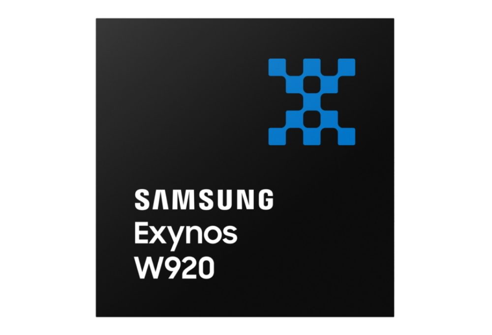
The Exynos W920 offers high performance, efficiency and LTE connectivity in tiny form factor
Image: Samsung
Samsung Electronics is offering a new processor for wearables, the Exynos W920. The new processor integrates an LTE modem and is built with an advanced 5-nanometer (nm) extreme ultraviolet process node, offering powerful yet efficient performance demanded by next-generation wearable devices.
The Exynos W920 is embedded with a GNSS L1 receiver (GPS, GLONASS, Beidou, Galileo) for tracking speed, distance and elevation during outdoor activities. It also has a 4G LTE Cat. 4 modem.
“Wearables like smartwatches are no longer just a cool gadget to have. They’re now a growing part of our lifestyles to keep you fit, safe and alert,” said Harry Cho, vice president of System LSI marketing at Samsung Electronics. “With the Exynos W920, future wearables will be able to run applications with visually appealing user interfaces and more responsive user experiences while keeping you connected on the go with fast LTE.”
The Exynos W920 has two Arm Cortex-A55 cores for high-performing, power-efficient processing and an Arm Mali-G68 GPU with CPU performance improved by 20 percent and 10 times better graphics performance than its predecessor. With upgraded cores and improved performance, the Exynos W920 enables faster application launches and more interactive, eye-catching 3D graphical user interface (GUI) on a device’s qHD (960×540) display.
The Exynos W920 comes in a tiny package with Fan-Out Panel Level Packaging (FO-PLP). The technology incorporates the Exynos W920, power management IC and embedded multimedia card. The processor’s compact size allows smartwatches to house larger batteries or have sleeker designs.
Always-on-display (AOD) for wearables, especially for smartwatches, is a widely adopted feature as it makes it effortless to take a quick look at the time, notifications, missed calls and more without the need to wake the watch up from sleep mode. Rather than powering up the main CPU, the W920 activates a dedicated low-power display processor, the Cortex-M55, reducing display power consumption under AOD mode compared to its previous Exynos model.
The Exynos W920 supports a new unified wearable platform Samsung built jointly with Google, and will be first applied to the upcoming Galaxy Watch model.
The U.S. Department of Defense wants help making sense of commercially and publicly available information that could be used to detect GNSS disruptors, especially over large areas.
Obtaining the ability to detect and geolocate GNSS disruptions has been cited as an unmet need in a number of U.S. national policies and plans dealing with positioning, navigation and timing.
The recently posted solicitation calls the project “HARMONIOUS ROOK – Situational Awareness for Intentional Disruption of Global Navigation Satellite System (GNSS) Users.” The solicitation says:
“The Department of Defense (DoD) seeks commercial solutions leveraging machine-driven analytics and datasets derived from publicly/commercially available information (PAI/CAI) to provide a situational awareness capability for intentional global navigation satellite system (GNSS) disruptions. This solicitation is particularly focused on persistent, large-area coverage of falsified GNSS emitters that result in localized spoofing phenomenology.”
Studies and analyses by non-profit organizations and commercial entities have demonstrated the ability of non-governmental organizations to do this kind of work and produce remarkable results. In 2017, our Resilient Navigation and Timing Foundation detected and reported on widespread GPS spoofing in the Black Sea.
This acquisition is being led by the Defense Innovation Unit, or DIU. The unit was specifically created to accelerate the adoption of commercial technology and services by the defense and national security establishments. While letting a traditional DoD contract for a prototype can often take up to 18 months, DIU aims to award contracts within 60 to 90 days of identifying the problem.
To do this, DIU uses the government’s “commercial solutions opening” process, which is designed to be simple and quick.
Companies who provide analytic services and those who have unique data sets are both encouraged to apply. The deadline is August 23.
Dana A. Goward is president of the Resilient Navigation and Timing Foundation
An Interim Armored Vehicle “Stryker” and AH-64 Apache helicopters with Battle Group Poland move to secure an area during a lethality demonstration as part of Saber Strike 18 in June 2018. (Photo: U.S. Army/Spc. Hubert D. Delany III, 22nd Mobile Public Affairs Detachment)
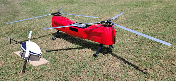
The Sicura EG-1100 (left) and Anzen EG-1250 with Sky Power engines are being exhibited at AUVSI Xponential. (Photo: UAS Global Services)
German engine manufacturer Sky Power GmbH is presenting its UAV engines at this year’s AUVSI Xponential show in Atlanta, Georgia. Plus, new Sky Power customer UAS Global Services of Texas will present two new helicopters, which are powered by different engines from Sky Power.
UAS Global Services will introduce its Anzen EG-1250 helicopter at the show. The Anzen EG-1250 is a heavy-lift, long-range, multi-purpose Group 3 platform. The helicopter will significantly expand UAS Global Services’ service as well as operational support offerings. Basic specifications include a maximum takeoff weight of 250 pounds (113 kg), a maximum flight time of up to 6 hours, a payload capacity of 75 pounds (34 kg), a cruising speed of 65 kts, and all-weather day and night capability.
The “EG” in the Anzen EG-1250 designation stands for a dual engine configuration consisting of electric and internal combustion propulsion. The main engine is Sky Power’s SP-180 SRE Wankel engine, while the secondary engine is a NeuMotors 12030/5.5. This 30KW electric motor can power the aircraft or serve as a power amplifier in combination with the SP-180 SRE. In addition to the added power and safety provided by the two motors, the Anzen EG-1250 is autorotatable and offers an optional safety parachute system.
UAS-GS was contracted by Ireland-based UAV Evolution Ltd. to develop the dual-rotor platform. After more than 5 years of development, the versatile design allows for a variety of engine, payload and operational options. The platform flexibility allows the Anzen EG-1250 to support a wide range of customers in the marine, agricultural, oil and gas, utility, cargo transport, security and other application sectors.
UAS Global Service’s second helicopter is the Sicura EG-1100, which is the third generation of the internally developed single-rotor helicopter. This flight system has become the workhorse of the UAS Global Services fleet in recent years and is now available to external customers. Basic specifications include a maximum takeoff weight of 55 lbs (25 kg), a flight time of up to 3.5 hours using an internal combustion engine or a flight time of 1 hour in electric mode, a payload capacity of 15 lbs (7 kg), a cruise speed of 55 kts, and a takeoff wind speed of 25 kts.
The EG-1100 is available with both electric and internal combustion engines. The combustion engine is Sky Power’s powerful and efficient SP-110 TS ROS two-stroke engine, which has been specially tuned and modified to the flight system. The result is competitive flight performance characterized by stable performance under severe environmental conditions, exceptionally stable flight, and immediate flight response during imaging and LiDAR operations.
With the EG-1100’s considerable payload capacity, customers can implement various transportation tasks in one mission. Different sensor and camera systems can be integrated simultaneously in the Sicura EG-1100, enabling multiple data-acquisition applications in a single flight. This significantly increases the efficiency of the overall UAS mission and provides the customer with timely, cost-effective and high-quality results.
For more information, visit UAS Global Services at the AUVSI show in Atlanta, booth 2498 or visit Sky Power at booth 2641.
The Arrow Gold+ and Arrow 100+ plus models build upon the company’s highest demand GNSS receivers
Eos Positioning Systems, the global manufacturer of the Arrow series of GNSS receivers, has released two new Arrow Series GNSS receiver models: the Arrow Gold+ and Arrow 100+.
These plus model receivers expand upon the features of Eos’ two most popular GNSS standard receiver models, the Arrow Gold and Arrow 100.
Arrow Gold+
The Arrow Gold+ (Photo: Eos Positioning)
The Arrow Gold+ includes all the features of the standard Arrow Gold GNSS receiver model. However, the plus model also includes several enhanced features:
A battery life 3.5 hours longer, for a total of 11 hours of field autonomy
Support for additional GNSS signals, including concurrent use of BeiDou B3 and GPS L5 signals when using RTK corrections
Support for the upcoming Galileo E6 High-Accuracy Service (HAS), which will broadcast differential corrections for GPS and Galileo satellites directly from the Galileo satellites
Built-in capabilities of the Eos Bridge to connect with external sensors
The ability to connect multiple mobile devices to a single Arrow GNSS receiver via Bluetooth (sometimes called “multipoint”)
Arrow 100+
The Arrow 100+ (Photo: Eos Positioning)
Arrow 100+ includes all the features of the standard Arrow 100 GNSS receiver model. However, the plus model also includes several enhanced features:
A battery life 6 hours longer, for a total of 18 hours of field autonomy
Support for Atlas H50 (Basic) service subscriptions, which provides 30-50 cm positioning accuracy worldwide when no SBAS or RTK network is available
Built-in capabilities of the Eos Bridge to connect with external sensors
The ability to connect multiple mobile devices to a single Arrow GNSS receiver via Bluetooth (sometimes called “multipoint”)
For a full comparison between standard and plus model Arrow GNSS receivers, view this FAQ article.
An Eos representative can help customers determine whether the new plus models are right for your needs. Authorized Arrow GNSS receiver reseller, contact Eos online.
 The Indian Space Research Organisation (ISRO) is conducting a free online course on GNSS for students and professionals Sept. 13-24.