Author: Tony Murfin

  • UAVs on the rise: Flying cars, medical deliveries, fighter support

    UAVs on the rise: Flying cars, medical deliveries, fighter support

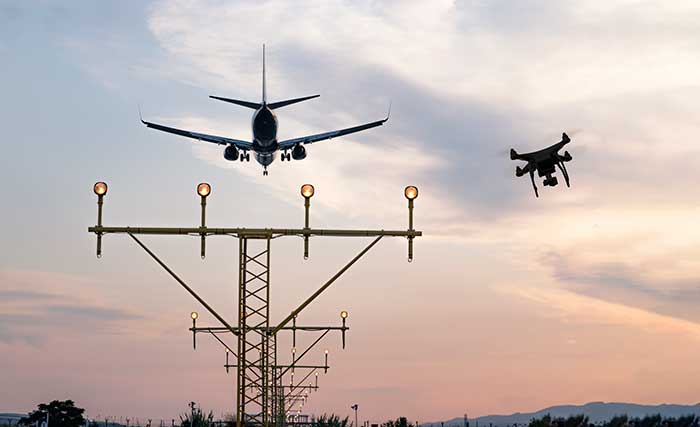
    A Loyal Wingman drone rolls out, the U.S. Air Force (USAF) sponsors air taxi-cargo UAS development, and medical deliveries take place in Scotland and Florida — we have quite a wide selection for this month’s news.

    Fighter support drone

    Boeing Loyal Wingman prototype (Photo: Boeing)
    Boeing Loyal Wingman prototype (Photo: Boeing)

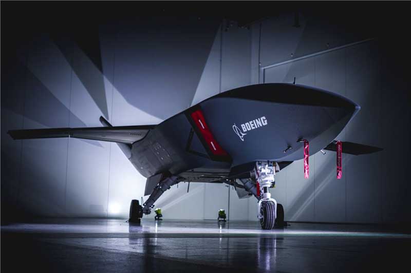
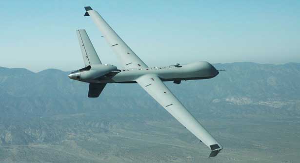
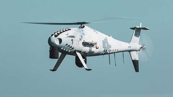
    Boeing Australia has just rolled out the first “Loyal Wingman” for the RAAF (Royal Australian Air Force) — in essence what looks like a completed first article of three prototypes on order for Australia’s Loyal Wingman Advanced Development Program.

    The concept is to develop an “inexpensive, expendable” UAV which will fight alongside today’s frontline fighter aircraft, controlled from the ground or from the air. A “force-multiplier” which doesn’t risk either pilot or the heap-expensive interceptor/ground attack aircraft themselves, a real bonus for smaller air-forces, and a less costly way of increasing numbers.

    The first prototype will now go into a ground and flight test program to prove out systems and flight capabilities – first flight would likely be later this year.

    A team of 35 Australian aerospace companies are supporting the Loyal Wingman project, including BAE Systems Australia which has been selected to supply the flight vehicle management system, flight control computers and navigation equipment.
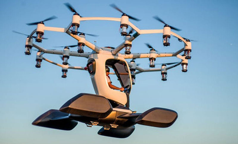
    Flying cars?

    The U.S. Air Force wants a fleet of them by 2023!

    So in a novel way to stir interest in the concept of flying cars, or perhaps cargo carrying drones, the Air Force launched a program known as “Agility Prime.” The program may have begun conventionally with seed contract(s) to drone manufacturers, but their latest “webcast” approach provided an extensive overview of what this could mean to the U.S. industry.

    From April 27 through May 1, a panel including Air Force leaders, two U.S. Senators, NASA and Federal Aviation Administration management, and key Air Force and Defense Department players participated in an open presentation to industry, investment and State Government participants — all with the aim of accelerating civilian development of “advanced air mobility vehicles.”

    Recognizing that a principle problem is overcoming regulatory hurdles, USAF intends to provide a route to commercial revenue service such as logistics transport and disaster recovery by perhaps providing access to its key testing capabilities and facilities. With broad participation in the program by industry, government and investors (i.e. USAF don’t intend to pay for it all) the program would satisfy an operational safety and security baseline and provide a platform for the “Race to Certification” of commercial drone product(s) the USAF might also want to buy.

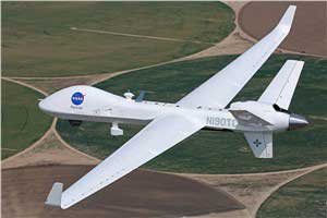
    One of the possible solutions for a cargo drone already funded includes the Sabrewing Cargo Drone – known currently as Rhaegal-A.

    Four electric powered ducted fans rotate for Vertical Take-Off and Landing (VTOL) and are powered by a Safran (French) Ardiden 3 helicopter turbine engine – giving this large UAV a design speed of 245 mph, a ceiling of 20,000 feet and range of 1000 miles.

    Sabrewing has received $3.25m under a two year USAF sponsored Small Business Incentive Research (SBIR) project in the hope that the design could be eventually adapted to military logistics applications. The vehicle is intended to be able to fly autonomously, has detect and avoid capability, and can even operate when GPS is continuously jammed — something the military would probably appreciate. Potential casualty evacuation is also of great interest.

    Medical supplies delivery

    Meanwhile in the U.K., in cooperation with the U.K. Civil Aviation Authority (CAA), Skyports drone company is playing in the CAA’s “Sandbox.” This is another term for an umbrella/sequence of trials under CAA safety and security constraints where innovative approaches are given a chance to demonstrate that new aviation related things are possible, that they actually work and that they meet the CAA criteria. Skyports wants to test out Beyond Visual Line of Sight (BVLOS) operations for its upcoming trial of medical deliveries between Oban and Mull off the West Coast of Scotland.

    As front-line health professionals fight to beat the COVID-19 pandemic, deliveries of essential medical supplies between medical facilities can be speeded-up significantly using drones. Skyports will begin the week-long trial between Mull and Oban medical centers in the last week of May.

    The planned BVLOS flights will be over a 17-mile route in unrestricted airspace and avoid the Oban airport, crossing the narrow sea channel and onto the North coast of the Isle of Mull. Skyports already has experience transporting medical and other high-value cargo in other parts of the world. The candidate drone is equipped with Iris Automation Casia detect-and-avoid computer vision system, and Thales Remote ID, and the Skyports drone team is also supported by Thales SOARIZON flight management and mission planning system.

    Drones to deliver prescriptions

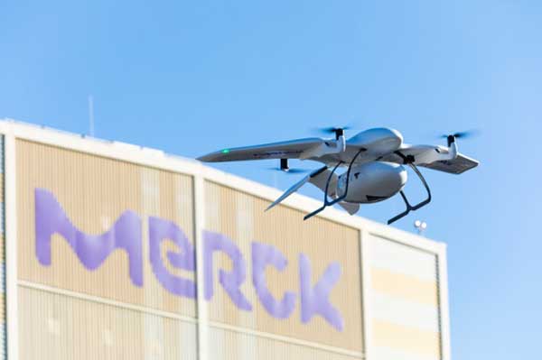
    And finally, something quite helpful during the current coronavirus pandemic — CVS and UPS having linked up some time ago, are to begin delivering prescription medication to customers in Florida. The process has been previously checked out during November last year trials in Cary, N.C.

    UPS will use the Swiss Matternet M2 delivery drone, picking up medication at specific CVS location(s) and flying it to a delivery point at “The Villages” in Central Florida, then the “last-mile” delivery is by road — presumably by an outfit which knows the layout of this huge facility where something like 130,000 retirees live. Useful during this phase of Florida’s self-quarantine for elders who may find it difficult to get out to the drug store. Hope they start running the same service out of my local CVS.

    Wrap-up

    So from the extreme military application of drone support for fighter attack missions, and USAF sponsored development of air-taxis and cargo drones, through to medical supply deliveries by drone in remote areas of Scotland and prescription deliveries in Florida — activity never seems to abate in this growing industry.

  • UAVs take flight for Mars, perform deliveries, more

    UAVs take flight for Mars, perform deliveries, more

    General Atomics MQ-9 Predator. (Photo: General Atomics)
    General Atomics MQ-9 Predator. (Photo: General Atomics)

    There has been a lot of scene stealing by General Atomics recently with Predators flying hither and thither, new orders for the Boeing-Navy unmanned re-fueling drones and a UAV flying on Mars — this month’s unmanned aircraft summaries.

    The Predator is the archetypical unmanned aircraft which most people might visualize as a “drone” as a result of numerous news reports and photos. Its what we might refer to a “Large UAV” with a 65-ft. wingspan, a 35 ft.-long fuselage and weighing in at around ~10,500 pounds fully fueled.

    The SkyGuardian. (Photo: General Atomics)
    The SkyGuardian. (Photo: General Atomics)

    In fact it’s bigger than a small manned aircraft, like the single engine Cessna 182 which checks in at 36ft wingspan/29ft fuselage. So its clear that something this big and without an on-board driver has to watch where its going, especially when flying within in the US National Airspace System (NAS).

    So it was no small feat when General Atomics recently flew a new MQ-9 Predator on a delivery flight from its flight ops center in Palmdale, California, to the Holloman Air Force Base in New Mexico. There was significant coordination by the flight teams in both locations, and with the approval by the FAA. Delivering a new Predator by air saves the Air Force significant manpower, as normally new ones arrive in a crate and require effort to re-assemble.

    It’s a sign of progress towards achieving approval to allow regular flights of such large UAVs in the NAS. Nowadays a Cessna 182 pilot can file a flight plan and then basically fly anywhere in unrestricted airspace. Hopefully one day — as a consequence of following rigorous certification verification and FAA approval – pilots of such Large UAS will be authorized to operate in a similar fashion.

    General Atomics is working with the U.K. Royal Air Force (RAF) to develop and certify the all-weather, long-endurance SkyGuardian MQ-9B variant to meet NATO-standard Type-Certification requirements, which will then enable the UAV to be flown in civil airspace. The Australian Defence Force (ADF) has also selected this UAV variant for its unmanned applications in and around Australia. In late March, General Atomics flew the first production representative SkyGuardian – known to the RAF as the ‘Protector’ – out of its flight ops facility in El Mirage, California.

    Staying with the military theme, Boeing has been working with the US Navy to develop a UAV that can land on aircraft carriers, and following a concept change by the Navy, won a contract to provide tanker UAVs. Tanker UAVs will fill up with aircraft gas on an aircraft carrier or land base, then take off and fly to rendezvous with fighter aircraft to transfer fuel and extend fighter endurance and range.

    Right now tanker aircraft are usually quite large aircraft – like the Boeing KC-46A tanker which is based on the Boeing B-767 civil transport aircraft which many of you may have flown on as passengers.

    The MQ-25 is still in its initial phases, with four test UAVs slated to undertake the initial flight test program. The first test vehicle has already begun exploring the UAV flight envelope and has 30 flight-test hours under its belt. The Navy has just shown confidence in the program by ordering another three aircraft, bringing the total initial build to seven vehicles.

    Its easy to see that UAVs are showing themselves to be extremely useful to military forces, but it might be difficult to understand how a UAV might find itself in the U.S. space program. The “Mars Helicopter” has just been mated to the underside of the next Mars Rover — now called “Perseverance” — both are slated to leave on their eight month journey to Mars in July this year.

    Mars UAV being mater with Perseverance. (Photo: NASA)
    Mars UAV being mater with Perseverance. (Photo: NASA)

    With two ~4ft rotors which spin in opposite directions, the UAV will have to wait patiently for up to 90 Martian Days after Perseverance touches down in February 2021 until it gets a chance to prove that it can fly in the thin Mars atmosphere — chamber tests here on Earth in simulated Mars air have already shown that flight should be feasible.

    Built to withstand high g launch and vibration forces and those of the Mars landing, the UAV carries a high resolution camera which is used for navigation, landing and survey of Mars’ surface. Its also designed to withstand the extreme temperatures and high radiation environment on the surface of Mars. The UAV is equipped with a dual-processor flight controller linked to sensors which include a gyroscope, an altimeter, visual odometer, hazard detectors and a ‘visual inertial nav system’ developed by JPL. Although the Mars Helicopter operates autonomously, it communicates with and receives control inputs from the lander, so controllers on Earth load up the flight plan ahead of time into the lander, and then wait for the helicopter UAV to execute the commands. Don’t expect vast coverage of huge panoramas of Mars – its flights are each intended to be more of an extensive hop lasting around 90 seconds at 10-15 ft above the terrain.

    Mars Helicopter on simulated Mars surface. (Photo: NASA)
    Mars Helicopter on simulated Mars surface. (Photo: NASA)

    With a body no larger than a softball and weighing less than 4 pounds, the Mars Helicopter is an experiment to see if its possible to fly in the extremely thin Martian atmosphere. With less than 1% the density of our sea-level atmosphere, its necessary to spin the rotors at 2,800 rpm, ten times faster than on Earth. The UAV collects power from its own small solar panel and needs several days to recharge after each flight — of which five are planned. The main objective if flight is possible is to pre-survey interesting potential routes for the lander.

    So preparations for large UAVs to regularly fly in civilian airspace, a new approach for Navy refueling systems, and a helicopter UAV destined to fly on Mars next year — completely different unmanned applications, all making progress.

  • Drones equipped with GNSS, inertial a game changer

    Drones equipped with GNSS, inertial a game changer

    Why do we keep hearing about unmanned aircraft all the time, almost everywhere? Fortunately, the buzz has gone beyond next-door neighbors flying dangerously close to your roof or hovering annoyingly around a living room window, and incidents of UAV incursions shutting down airports seem to be getting fewer — improved enforcement and higher penalties may be slowing down these incidents.

    Now, UAV users are taking on productive, innovative tasks that couldn’t previously be done, or finishing projects surprisingly quickly and more affordably than ever before, with drones built or adapted for new applications. And equipment manufacturers are creating new sensors customized for use on drones.

    Commercial, integrated GNSS/inertial sensors are available that have extremely high performance — previously only available with expensive mil-spec electronics — but in lightweight, small packages, supported by real-time kinematic (RTK), precise point positioning (PPP) corrections or post-processed kinematic (PPK). UAVs carry still, video and multi-spectral cameras generating automatically geocoded outputs, ready for post processing into multi-layered formats — virtually everything a customer could ever dream of having. And lidar sensors enable drones to build accurate models of everything they overfly.

    Drones originated largely with military forces. Originally used for forward intelligence gathering, UAV tasks have multiplied and substantially expanded in scope.

    Commercial industries were quick to realize the benefits. Before drones, the cost of many tasks done manually would be prohibitive and too time-intensive. Fast, affordable data collection now allows us to quickly tackle and solve many problems.

    UAVs can pre-survey large, previously inaccessible tracts of difficult terrain, collect detailed visual representations of entire cities, monitor and support crop growth, or even survey underwater terrain using lidar. UAVs provide crop-growing support by flying autonomous patterns and spraying fields with pesticides or fertilizer. They also are being called into service to spray villages with disinfectant to control the spread of coronavirus, and to survey England’s beaches to monitor coastal erosion.

    Check out some case studies here:


    Featured photo: PhonlamaiPhoto/iStock / Getty Images Plus/Getty Images

  • Conducting integrated drone surveys at a congested airport

    Conducting integrated drone surveys at a congested airport

    Photo: Joel Papalini/iStock / Getty Images Plus/Getty Images
    Photo: Joel Papalini/iStock / Getty Images Plus/Getty Images

    Airports are extremely congested spaces, both on land and in the air, making it difficult to conduct surveys that provide insights into their continued monitoring and maintenance.

    UAVs create the opportunity to survey such sites safer and faster, reducing disturbances to everyday operations while collecting a level of detail unparalleled by conventional surveying techniques to locate and accurately capture areas in need of maintenance and management on airport runways.

    Following several drainage and grading issues throughout a 650-acre airport, Texas-based civil engineering company Gessner Engineering was contracted to provide surveying services to identify the most problematic regions.

    The team had to conduct the survey with minimal impact on runway operations. By coordinating with the airport’s air traffic controllers, the team planned a 6–8-hour flight window, with just a few pauses for ongoing traffic, while the airport operated as usual.

    Before the flight, the surveyors used senseFly eMotion flight-planning software to carry out pre-flight risk assessments and plan flights. During the survey, four 20-minute flights were completed with the senseFly eBee fixed-wing drone. With its fully autonomous and easy-to-use aerial mapping capabilities, the eBee was able to capture the high-resolution aerial photos needed to map the entire airport. The data was processed using Pix4D Mapper to generate a topographic model including a point cloud with a ground sample distance of 1.5 inches.

    The point cloud was so comprehensive, it brought attention to four more areas with drainage issues, providing a level of detail that would not have been possible using only a ground GNSS base station. The UAV survey took one day, compared to four weeks for traditional surveying. This cut the project time in half and significantly reduced disturbances to airport operations.

    “The savings in manpower with the shorter surveying time, accurate data retrieved, and the additional drainage issues identified demonstrate the value of drones, as an enabler of solving complex challenges in congested airspaces, especially where time is limited,” said Troy Hittle, general manager, North America, SenseFly. “The success of this project by using UAV equipment has offered new possibilities to both Gessner Engineering and the future of aviation maintenance.”

  • Skycatch system provides in-the-field UAV maps

    The Edge1 system by Skycatch is a combination GNSS base station and drone data-processing unit that delivers high-accuracy maps and point clouds in minutes.

    The high-performance built-in Nvidia TX2 Mobile GPU enables both maps and point-cloud processing locally within 30 minutes, as well as running artificial intelligence (AI) tasks in real time.

    The base station of the Edge1 uses a Swift Navigation dual-frequency GNSS real-time kinematic (RTK) receiver. The receiver supports signals from GPS, GLONASS, BeiDou and Galileo, enabling reliably fast centimeter-level accuracy globally even in remote locations, with reliable 5-centimeter accuracy.

    Users of the Edge1 system can process and receive their maps in the field, without the need for internet connectivity to process data. The system automatically generates 2D maps and 3D data, with the capability to download and use them in Skycatch’s Data Hub, as well as commonly used programs like Civil 3D, BIM360 and others.

  • AG Surveys collects topographic beach surveys throughout England

    AG Surveys collects topographic beach surveys throughout England

    Prepping for flight: Andreas Garbe, AgSurvey, sets up the UX5 HP for a topographic survey at Severn Beach, a village in South Gloucestershire. (Photo: Trimble)
    Prepping for flight: Andreas Garbe, AgSurvey, sets up the UX5 HP for a topographic survey at Severn Beach, a village in South Gloucestershire. (Photo: Trimble)

    Based in Bristol, AG Surveys has been collecting topographic beach surveys around the country as part of England’s Environment Agency’s coastal monitoring campaign.

    In the first integrated approach of its kind in the program, AG Surveys uses the Trimble UX5 unmanned aerial system (UAS) equipped with a Trimble/Applanix GNSS receiver along with photogrammetry software. The UAS-based system has not only confirmed its viability for coastal monitoring, it has been bringing new business opportunities ashore since 2017.

    For each beach, AG Surveys must provide one baseline survey based on a 5-meter grid with a height accuracy of 3 centimeters. Also required is a series of profile line surveys. Profile surveys follow pre-defined lines set every 50 meters from the back of the beach to the low tide line, with GNSS measurements taken within 10 centimeters of each side of the line.

    Crews typically cover 3 square kilometers a day, flying four to five Delair drone flights at an altitude between 100–120 meters, at speeds of 80 kph and a lateral overlap of 80%. To ensure the reliability and accuracy of the UAS data, they use a minimum of 10 ground control points (GCPs) for each flight block and measure each target’s position with a GNSS receiver.

    Once flights are complete, the team imports into Trimble Business Center (TBC) the flight and GNSS data and the base station survey data. Using both on-board GNSS positioning data and the ground control data, they process precise, short baselines between the base station and each photo point. All images are then integrated into Trimble’s Inpho UASMaster software to create a dense point cloud and a seamless orthophoto of the entire area of interest. (UASMaster is now integrated into the TBC Aerial Photogrammetry Module). If needed, they can also use UASMaster to produce a seamless, georeferenced orthophoto directly from the point cloud.

  • Unicore GNSS guides XAG Drones in China

    Unicore GNSS guides XAG Drones in China

    XAG introduces agricultural drones for farmers in China. The XMission drone can reduce costs on fertilizer, pesticides and other treatments. (Photo: XAG/Unicore)
    XAG introduces agricultural drones for farmers in China. The XMission drone can reduce costs on fertilizer, pesticides and other treatments. (Photo: XAG/Unicore)

    Pesticides, fertilizers and water are the most important means to enhance agricultural crop production.

    The prevalent infestation of fall armyworm in China has resulted in reduced yields, threatening food security and the livelihood of smallholders. It’s impractical to conduct manual spraying over farmlands larger than 5 hectares, and this also runs both the risk of wasting large amounts of pesticides and chemical poisoning.

    Given the situation, smart agriculture devices such as drones have come in handy for fixing these problems, with minimal environmental impacts. In China, professional farmers and agricultural service providers have already harnessed existing drone technology to conduct appropriate chemical sprays to safeguard the country’s crop production.

    The XAG XMission drone has centimeter-level navigation and can operate fully autonomously over complex terrain and easily adapt itself to different spraying conditions for various crop species. Farmers are therefore relieved from much physical effort while no longer risking their health in the battle against fall armyworm.

    Equipped with Unicore’s high precision dual-antenna GNSS module (UM482), dual RTK plus GNSS positioning system, real-time centimeter-level flight positioning provides reliable data support in various air tasks. XAG’s drone carries a 4G communication module connected to the XAG Cloud RTK network in order to immediately start missions without setting up portable ground RTK bases.

    Unicore UM482. Unicore’s GNSS high precision module (UM482) provides centimeter-level accuracy real-time positioning, with 0.2°, 1-meter baseline course information. UM482 supports single-module dual-antenna signal access and has a dual-RTK engine, enabling high-precision, high-reliability directional heading and dual-RTK real-time positioning, with each RTK engine calculating position independently. This receiver meets the flight needs of different types of UAVs for many different scenarios.

    Virus Fighting. XAG’s drones have also joined the fight against the spread of the coronavirus. In Feburary, XAG announced a 5-million-yuan fund for coronavirus response, to be put toward aerial disinfectant sprays to curb the spread of the virus in rural areas. The company’s fleets were used in China’s Shandong province on Jan. 28, where they reportedly disinfected a local community of more than 300,000 square meters in less than 4 hours.

  • Wingtra brings wind energy to the Swiss Alps

    Wingtra brings wind energy to the Swiss Alps

    Photo: Wingtra
    Photo: Wingtra

    Site-survey preparations for a windfarm of 20 300-foot tall wind turbines might have been quite complex for a location in a 2,500-foot-high valley in the Swiss Alps.

    However, the contractor decided to use a drone with vertical take-off and landing (VTOL) capability supplied by Wingtra to speed up the work and produce highly accurate geo-referenced data. Although multirotor drones are normally used for detailed survey work, they can cover much less area than fixed-wing drones during the same flight time. Fixed-wing drones can fly longer, farther and carry more weight.

    Multicopters tend to carry more expensive, higher accuracy sensors because the sensors are not subject to potential damage from fixed-wing belly landings. Wingtra solved this problem by developing a drone with vertical take-off, the ability to transition to horizontal flight and to then land upright. When equipped with heavier, more accurate sensors, longer and more complex surveys are possible.

    The Septentrio AsteRx-m2 was also chosen for the WingtraOne drone. The AsteRx-m2 is a high-precision, multi-frequency, four-constellation, PPK, low weight and power GNSS module. The low-latency AsteRx-m2 works for both rotorary- and fixed-wing UAV applications.

    The WingtraOne VTOL drone is able to cover 400 hectares (an area of around 570 football fields) in one 55-minute flight. The resulting mapping accuracy is as high as 1.27 centimeters (0.5 inches). The drone was equipped with the full-frame 42MP Sony RX1RII camera, with seven ground control points for increased accuracy.

    The WingtraOne took off vertically and transitioned to fly horizontally at the planned 1,500-foot altitude. Each flight took about 20 minutes to plan and involved 30 minutes of flying time. The flights covered a total area of 1,100 hectares — each flight was 200–300 hectares.

    Aerial data collected from the site was converted to 3D models that allowed visualization of planned roads and wind-turbine locations in the wind farm. The data-collection workflow only took 4 hours rather than the days required with traditional surveying. Use of high-end sensors ensure survey-grade imagery and accuracy — in this case, the engineers obtained an accuracy of 3–4 cm.

    Flying in an area as difficult as the Swiss Alps to collect aerial data has been one of Wingtra’s most complicated challenges. By reducing costs and the time to complete the survey and evaluation of the proposed site, the customer was able to maintain the overall wind farm project timelines.

  • Delair drones mine for data

    Delair drones mine for data

    When Trimble sold its Gatewing fixed-wing drone business to Delair in October 2016, its decision was based on several drivers. Trimble had worked with Delair since 2008 and knew their capabilities; the company decided that a dedicated drone company should be better placed than a GNSS manufacturer to find and develop leading-edge drone business. Also, the sale enabled Trimble to better focus on integrated UAS software technology for positioning, remote sensing and photogrammetry. Delair joined up with Microdrones, a supplier of multi-rotor UAVs, to round out the team’s offerings. Both companies are skilled in the application of Trimble UAV software.

    Typical Delair drone applications include rapid data gathering using the UX11 fixed-wing drone, followed by data analysis leading to highly accurate survey-grade results.

    For the Johnson Poole and Bloomer (JPB) mine sites, personnel safety was an important driver in moving away from having people on the ground collect data, sometimes in dangerous situations. Time and cost savings have now become the norm for JPB survey operations, particularly for stockpile volume calculations.

    With the UX11 flying at 400 feet for 40–45 minutes, up to five times each day, it is possible to collect thousands of photos of many acres — ending with an accuracy of around 1.7 centimeters.

    The UX11 drone is equipped with a high-precision Septentrio AsteRx-m2, providing post-processed kinematic (PPK) multi-frequency, four-constellation signal reception. The AsteRx-m2 is also low power and low weight.

    Another mining operation using Delair drone survey and analysis tools is Luck Stone in Virginia. With numerous quarries in Maryland and Virginia, Luck Stone produces aggregates and more than 75 crushed stone, sand and gravel products for civil engineering, private construction and environmental projects. Luck Stone also finds that inspection staff safety is significantly improved, as is the time for such inspections, and asset inventories are not only accurate but also can be undertaken quickly and much more often.

    Delair has just released a new agriculture system with the fixed-wing Delair UX11 Ag, along with the Delair Aerial Intelligence (delair.ai) processing system. An integrated and easy-to-use workflow has been developed to collect, manage, analyze and share agriculture data for crop health monitoring, field experimentation analysis, automatic machine guidance, precision ag practices and better crop traceability.

    The new system makes use of PPK for precise auto-geolocation. The UX11 Ag drone carries a fully integrated high-grade multispectral camera for the data collection and monitoring of plant health.

    Delair.ai supports tools that provide visual field maps, identifying plant health by chlorophyll content, green biomass, stoutness/visual health and other plant indicators. The drone enables spray prescription preparation to counter weeds, disease and pest infiltration. UAVs also make it possible to determine the effectiveness of treatment regimes.

    In addition, Delair has developed the DT26 fixed-wing series of longer range drones for two-hour lidar survey flights and for surveillance; it can be adapted to carry other customer payloads. The DT26 uses an Applanix/Trimble GNSS receiver.

    Delair customers also use their drones for power-line inspections and in the oil and gas industry for site preparation surveys and pipeline inspections. The UX11 was the first drone from a Trimble partner to provide a JXL file for processing UX11 data in the Trimble Business Center.


    Featured photo: Delair/Trimble

  • UAVs monitor marine emissions, string powerlines

    UAVs monitor marine emissions, string powerlines

    A couple of interesting drone applications came up this month — marine smoke emission monitoring and studies from a little known European drone manufacturer.

    Monitoring marine emissions

    Climate change: Some might say these are words we don’t really need to hear. Such a big to-do about how much human activity is affecting the weather changes that we are now seeing globally. Or is it all part of a natural cycle that the Earth is going through as many might say?

    I don’t really want to get into that argument, but it would seem useful that someone is doing something to reduce the use of dirty fuels by ships. After all, we seemed to readily acquiesce to unleaded fuel for our vehicles without a lot of protest; why would we accept this as the norm when marine transport still uses dirty bunker fuel, belching out a significant amount of pollution?

    If it’s good for people and their cars, and we quite possibly incurred some costs getting there, why not stick it on the marine industry too?

    So that’s what the International Maritime Organization (IMO) did in January this year, reducing the allowable sulphur content in marine fuel from 3.5 to 0.5%. Enforced under the international convention for the prevention of pollution from ships, this is aimed at cutting sulphur oxide emissions from ships by 77%, equivalent to a reduction of about 8.5  million metric tons annually.

    That’s the tricky bit – enforcement. Ships spend most of their time miles away from land, so knowing what their smoke emissions contain is somewhat difficult. Now (this is where I manage to tie things back to what I’m supposed to be reporting on) its useful that Schiebel, along with its partner operator Nordic Unmanned, thought about enforcement of the new regulations.

    Schiebel Camcopter S-100. (Photo: Schiebel)
    Schiebel Camcopter S-100. (Photo: Schiebel)

    With a range of up to 200 kilometers (~125 miles) the Camcopter S-100 can get out to the shipping lanes to check on what’s coming out of the smokestacks. Equipped with an automatic identification system (AIS), a sulphur sniffing sensor and an L3 Harris Wescam MX-10 real-time electro-optical/infrared (EO/IR) camera, the “enforcement drone” can determine which ship it’s flying over, what the smoke plume sulphur content might be, and even take geo-coded pictures to show in which jurisdiction the ship is sailing. If necessary, it can even take pictures of who’s throwing what at the overflying UAV.

    In recent tests, the Camcopter flew out of Gniben, Denmark, where European regulations on emissions applied, and marine exhaust fumes are limited to contain no more than 0.1 percent sulphur oxide. The Camcopter S-100 performed two 4- hour flights and provided real-time readings of the sulphur level in ships’ exhaust plumes.

    With these successful tests in the bag, Nordic Unmanned has indicated its capabilities to worldwide maritime authorities that they are ready and able to help enforce the new IMO regulations.

    European-built multi-rotor drone

    Acecore Technologies in the Netherlands makes multi-rotor drones which have found some unique applications:

    The NEO 8-rotor UAV. (Photo: Acecore)
    The NEO 8-rotor UAV. (Photo: Acecore)

    Stringing power-lines using NEO (SPIE website)

    In order to extend power transmission line capacity, the approach used is often to first pull a lead cable. This  normally involves several power company personnel and a whole bunch of specialized equipment.

    However, in a first-of-its-kind test, SPIE Nederland used an Acecore NEO drone to pull a lead cable over 150 meters between high-voltage pylons.

    Equipped with suitable cameras and other sensors, Acecore drones have also been used for power-line and gas-plant thermal inspection, movie making (including Game of Thrones), live broadcasts, autonomous aerial surveying, and tethered security applications. They also make crop health monitoring possible.

    Designed with durability in mind, Acecore drones are weather-proof, built with strong carbon-fiber frames, have triple redundant autopilots, and are ADS-B-ready to broadcast GPS position to support sense-and-avoid capability.

    Acecore is also promoting the fact that its drones and controllers are manufactured entirely with European parts. In other words, they would like to grab a chunk of DJI’s huge market share by jumping on an apparent global move to switch over from Chinese sourced goods and equipment.

    So, drones are taking on environmental monitoring. They’re reducing the environmental impact of transmission-line build-out. And they’re moving  toward building drones locally — all are interesting new applications of unmanned aircraft systems.

    Tony Murfin
    GNSS Aerospace

  • Coronavirus, organ transport top medical drone uses

    Coronavirus, organ transport top medical drone uses

    With Coronavirus all over the news, it’s actually encouraging to hear that China is making high-level efforts to contain the infection: two isolation hospitals built in just one week in Wuhan where the outbreak began, travel restrictions inside China, very few people being allowed to leave the country, enforced mask-wearing, and local communities in neighboring provinces blocking visits by outsiders.

    Two drone-related stories caught my attention, both in China and connected to the virus outbreak — one where drones were being used to enforce “wear-a-mask (see video), and another where disinfectant was being dispensed by drones.

    Photo: Xag
    Photo: Xag

    It’s not exactly clear who was behind recent drone flights that broadcast live warnings to people without protective masks on the streets — some villages in rural China were apparently overflown and people were advised to wear a mask while outdoors.

    Around Beijing, similar activities were maybe down to well-intentioned social media people and traffic police.

    XAG, which has fielded 42,000 agricultural spraying drones in China, is urging authorities to use its drones for widespread disinfectant spraying, and has set up a significant fund to support these activities. The company claims its drones can disinfect a local community in less than four hours, and may already have done so.

    Medical transport drones. Staying with the medical theme, Aquiline Drones (AD) in Cincinnati is a drone company operating under a Federal Aviation Administration (FAA) Part 135 Air Carrier Certificate, and is working on a system to transport human organs for transplants.

    VyrtX is an organ transport company in Ohio that has teamed with AD, with the object of creating a highway-in-the-sky across the state to overcome ground delivery delays. Apparently around 25% of precious transplant organs don’t make it in time to be used; they are lost to the patients on lengthy wait lists — and many people are dying as a consequence. There are supposedly enough donors, but organs deteriorate during ground transport and desperate transplant candidates are losing out badly.

    So the next step for VyrtX and AD are custom-designed drones for life-saving rapid transport between donor and transplant hospitals. VyrtX is working with the U.S. Air Force Research Laboratory in Dayton, the Ohio UAS Centers and four Ohio organ procurement organizations to develop the air corridor and begin rapid organ transport by drone across the state.

    The University of California, San Diego, Health (UC San Diego Health) is joining an increasing number of health organizations in developing a drone system for blood and documentation transport between its facilities. Collaborating with the UPS Flight Forward drone delivery program and with Matternet, medical payloads will travel between Moores Cancer Center and Jacobs Medical Center. The Center for Advanced Laboratory Medicine, about 1.5 miles north, will be added provided initial test flights work out well.

    Trained professionals will load and operate the drones, which will follow predetermined, low-risk flight paths and will carry no cameras. (Photo: UC San Diego Health)
    Trained professionals will load and operate the drones, which will follow predetermined, low-risk flight paths and will carry no cameras. (Photo: UC San Diego Health)

    UPS Flight Forward is another company that was granted (FAA) Part 135 Air Carrier authorization and is already operating a UAS delivery program at WakeMed Hospital in Raleigh, N.C.. UPS Flight Forward is also planning with CVS to deliver prescriptions and other products to CVS pharmacy customers.

    Another drone medical supplies delivery system in Tanzania ran an operational trial in the fall of 2018. Wingcopter (a German drone manufacturer), Deutsche Gesellschaft für Internationale Zusammenarbeit (GIZ) GmbH and DHL flew medicines from the mainland to an island. The DHL Parcelcopter completed a 60-km route autonomously in around 40 minutes, for a total of 2,200 km flown during the pilot project.

    Building on these earlier trials, Wingcopter is now working with Merck and the Frankfurt University of Applied Science to demonstrate a drone delivery system between two Merck facilities in Germany. The object is to show the benefits of direct drone airborne transport over trucks for moving small packages between a Merck lab in Gernsheim to its headquarters in Darmstadt.

    The first flight was recently accomplished over roughly 15.5 miles between the facilities, carrying a sample of pigments.

    Photo: Wingcopter
    Photo: Wingcopter

    The BVLOS (beyond visual line of sight) flight passed over a dense metropolitan area, power lines, railways, and roadways. Benefits include time savings of around an hour, provided much greater savings at some times, and avoided significant ground vehicle emissions.

    To sum up, drones being used to help combat coronavirus, to reduce time and costs for the transport of medical samples and supplies over medium distances, and there’s a spin-off with potential commercial promise, too. It’s a good month for the drone industry…

    Tony Murfin
    GNSS Aerospace

  • The rise of UAVs in agriculture, airports, more

    The rise of UAVs in agriculture, airports, more

    UAVs are finding places in the lives of more people than ever — farmers employing crop-spraying drones to counter a locust infestation in Pakistan, finding the way towards useful inspection tasks at an operating airport in the U.K., large airborne vehicles providing joy-rides around the U.S., and unfortunately showing up where they are not wanted so security staff have to use protection systems to deal with them.

    Crop Spraying

    New unmanned air vehicle (UAV) applications keep appearing. Once they do, they start to spread locally and even around the world. Crop management using UAVs has significantly progressed.

    The U.S. has used crop spraying to improve crop yield for many years, defending against insect infestation and plant diseases. GNSS guidance systems for crop-spraying aircraft was an early satnav equipment application that eventually became a standard for any fliers contacted by farmers to apply pesticides to protect their crops. Then companies began offering turn-key spraying, which was highly efficient and effective.

    UAVs are now entering this segment — they are capable of carrying higher capacity tanks, and autonomous/semi-autonomous navigation enables spraying with minimum supervision. This option is becoming more readily available to the farmer and costs less than using manned aircraft.

    Both Japan and China have used UAVs extensively for crop spraying; other countries turning to the solution are Africa, the U.S. and India. In China, more than a hundred different types of UAV are in use in agricultural applications.

    Farms around the mega-city of Karachi, Pakistan, have been infested by locusts, but the local government is short of the helicopters and ground applicators normally used for spraying pesticides. A recent graduate returning from his doctoral course in China brought with him knowledge of unmanned vehicle use in agriculture, and is urging rapid local adoption of UAV technologies to combat the locust infestation.

    Pakistani agriculture expert Shahzad Nahiyoon claims that UAVs are better suited to crop protection for small farms within difficult contours of the surrounding region. They are less expensive to operate than manned fixed-wing and rotary aircraft, may be operated locally from outside spray contamination zones, and can spray in confined areas. Equipped with a 20-liter tank, spraying one or two 20-meter-wide swaths, 6 to 10 hectares per hour can be treated.

    Drones at the airport

    Growing a little weary of drone incidents around airports, I was pleased to see a report I had overlooked from a year ago which indicated that trials at Manchester airport in UK had demonstrated airport and drone compatibility. This basically happened because an Air Traffic Control (ATC) system for unmanned aircraft or Unmanned Traffic Management (UTM) was shown to keep drones flying around the airport under full control while integrated with regular airport and drone operations.

    The trial — referred to as Operation Zenith — sponsored by the National Air Traffic Systems (NATS), made us of the GuardianUTM airspace management system, supplied by Altitude Angel, as the control system for eight trial drone missions at the airport. The drone UTM system was connected to the real-time Air Traffic Management (ATM) system which manages ground and air traffic at the airport, to ensure the control and safe separation of drones and aircraft. The UTM system also provided controllers with a real-time view of all operating drones.

    The trial demonstrated the efficient regulation of drone traffic within and around the extremely sensitive airport region. Everyone engaged in the trial made use of real-time electronic map displays driven by the UTM system, showing everything flying in and around the airport; aircraft and drones. Drone pilots used this information to ensure their operations remained safe while operating so close to commercial aircraft in the air and on the ground.

    NATS has now formed a strategic partnership with Altitude Angel to deliver this integrated UTM system at airports in the United Kingdom. The UTM system has successfully completed initial pilot trial and evaluation and now NATS intends to further demonstrate UAV management control at six U.K. airports later this year.

    Thousands sign for ride with Lift Aircraft

    Hexa in flight (Photo: Lift)
    Hexa in flight (Photo: Lift)

    Lift Aircraft unveiled its 18-rotor Hexa unmanned/manned aircraft more than a year ago — what’s new now is that 13,000 people have signed up to take one for a ride.

    The large drone weighs in at 432 pounds and can fly for 10-15 minutes with a single passenger.

    The Hexa is controlled by a single joystick, and an onboard iPad provides route guidance and manages take-off and landing. Classed as a powered ultralight air vehicle, it can be flown without a pilot’s license, so Lift announced that it will offer Hexa flights to anyone wanting to fly (in 25 selected U.S. cities) provided they physically fit into it and weigh less than 250 pounds.

    Lift intends to map each recreational flight area in 3D, and plug this map into the vehicle control system. The 13,000 people who signed up can expect to pay $125-250 for each joy ride. Lift has yet to announce the first location where the fun rides will take place.

    Counter-UAS system downs drones in Philippines

    The Southeast Asian Games were recently held in the Philippines with thousands of participants from eleven countries of Southeast Asia — the event was spread across 23 cities around the country. However, a number of uninvited drones showed up during the opening ceremonies on November 30th to take a look, but fortunately all were quickly dispatched.

    The DroneShield counter-UAS system had been deployed in advance for protection of the event, and the local security forces used the system to detect and disable the invaders. According to the company, security personnel found the drones using body worn RF detection devices, and the Dronegun was then used to disable them.

    Jamming the control link and GNSS L1 and L2 frequencies, UAVs are generally stopped in mid-flight when illuminated by the rifle-like device. DroneNode jammer in a suitcase was also used to provide blanket protection over a 1km circular area when the alarm was raised.

    In all, seven unauthorized drones were disabled, some of which were apparently flying near the intended flight path of the helicopter bringing President Rodrigo Duterte to the opening ceremony.

    Summary

    It might seem a little ridiculous that we’ve had to come up with systems to counter uninvited or malicious drones (C-UAS). Making provisions for protection is probably something most sensitive facilities will have to do. Its possible that governments may already be investing in such technology to protect many facilities. More drones available for useful, productive and even recreational applications means some can end up in the wrong hands.

    Nevertheless, good stuff comes out of drone applications, and the benefits seem to by far outweigh the need to protect ourselves against bad actors.