Category: Autonomous

  • Swift Navigation and Deutsche Telekom announce partnership

    Swift Navigation and Deutsche Telekom announce partnership

    California-based Swift Navigation is partnering with Deutsche Telekom, an integrated telecommunications company based in Bonn, Germany. The partnership brings the precise positioning of Swift’s Skylark Cloud Corrections Services to Telekom’s comprehensive communications infrastructure via its new Precise Positioning product offering.

    The Precise Positioning service is available across the United States and Germany, with expansion across Europe underway.

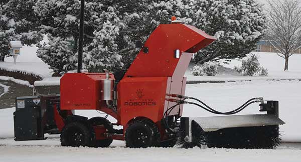
    Autonomous applications. Autonomous applications, which rely on positioning accuracy, include self-driving cars, rail, autonomous robotic machine navigation, autonomous flight for unmanned aerial vehicles, last-mile delivery logistics, construction safety, and shared mobile positioning.

    Swift and Telekom’s lane-level accurate Precise Positioning is specifically designed for level 2 and 3 automotive applications including advanced driver-assistance systems (ADAS), such as lane assist, highway autopilot, cellular vehicle-to-everything (CV2X) communications and lane level directions.

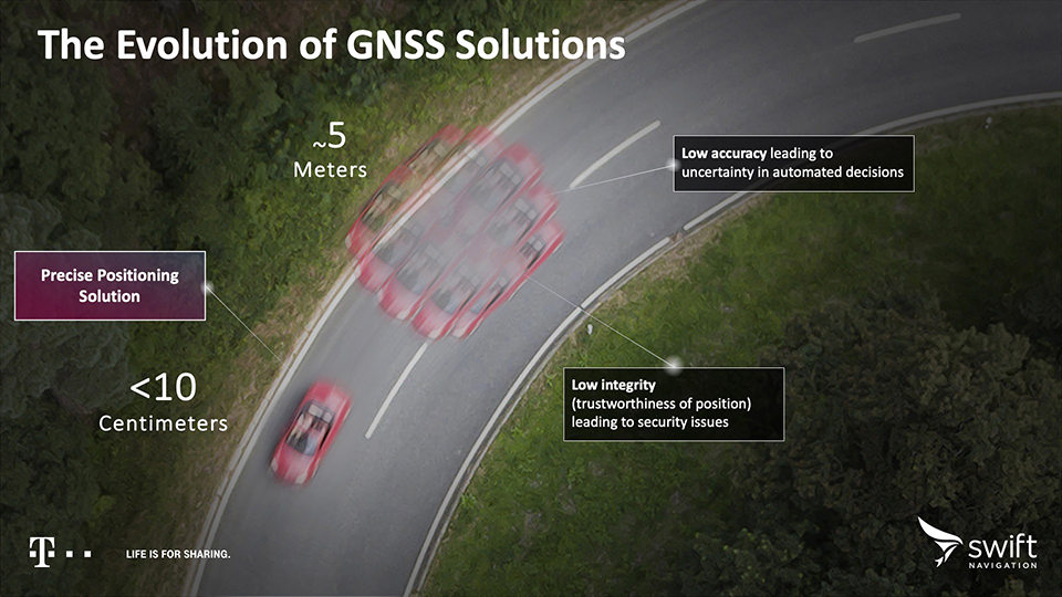
    Standard GNSS positioning is accurate to three to five meters — unsuitable for autonomous systems. For higher levels of autonomous capability, high-precision localization is required to deliver accuracy down to the centimeter. This partnership brings the <10-centimeter accuracy of Swift’s precise positioning solution to Telekom customers.

    Precise Positioning is a wide area, cloud-based GNSS corrections service that delivers real-time high-precision positioning to autonomous vehicles. Built from the ground up for autonomy at scale, the Precise Positioning service enables lane-level positioning, fast convergence times and high integrity and availability required by mass market automotive and autonomous applications.

    Image: Swift
    Image: Swift

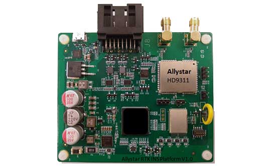
    Hardware-Independent. The service is hardware-independent, allowing customers to choose their GNSS sensor ecosystem. It delivers a continuous stream of multi-constellation, multi-frequency GNSS corrections for a high-availability service that combines lane-level accuracy and world-class integrity at a continental scale.

    “Swift Navigation is excited to continue our work with Telekom to bring Swift’s precise positioning GNSS expertise to Telekom’s broad customer base,” said Timothy Harris, co-founder and CEO at Swift Navigation. “This partnership is just the beginning of our joint service offering for autonomous vehicles across the EU.”

    “Precise Positioning opens the doors to true autonomous mobility. Precise, safe and in the future also cross-national,” said Hagen Rickmann, responsible for business customers at Deutsche Telekom. “We are thus offering our customers an easy entry into the autonomous future. And we’re not just thinking of self-driving vehicles: The flexible offer is also suitable for use with drones and is even of interest to crane operators on construction sites.”

    For ease in testing and integration, Swift and Telekom have created a Precise Positioning Evaluation Kit. The kit includes two workshops (onboarding and result review), testing hardware and software to connect to the Precise Positioning network for a three-month evaluation period and is available to purchase.

    Image: Swift
    Image: Swift
  • DeepRoute debuts autonomous vehicle tech at CES 2020

    DeepRoute debuts autonomous vehicle tech at CES 2020

    Screenshot: DeepRoute
    Screenshot: DeepRoute

    Technology includes vehicle-grade computing platform solution, high-dynamic range camera and ADS synchronization controller

    DeepRoute, an international self-driving startup and CES 2020 Innovation Award Honoree, will be debuting three innovative technologies at CES 2020 including a vehicle-grade computing platform solution, DeepRoute-Tite, high-dynamic-range camera and ADS synchronization controller.

    CES 2020, the massive annual consumer electronics show, is taking place Jan. 7-10 in Las Vegas. The company will be located at Booth no. 25647 at South Hall 2 LVCC throughout the show.

    “It is an honor to be joining international innovators at CES 2020,” said Shuang Gao, Chief Operating Officer of DeepRoute. “We’ve worked hard over the last year to perfect our technologies and reinforce the safety of autonomous vehicles. We are excited to unveil the fruits of our team’s hard work, creativity and talent to the world at the prestigious and highly anticipated global technology show.”

    DeepRoute-Tite, the company’s computing platform solution that migrates the algorithm required for L4 level autonomous driving to the vehicle-level computing platform, Nvidia Xavier, significantly reducing the cost, size and power consumption down to 45 watts. DeepRoute’s computing platform solution uses Nvidia’s vehicle-specific computing platform Xavier to process L4 level autonomous driving modules such as perception, prediction, decision-making, planning and control, along with navigation.

    Along with the debut of the computing platform, DeepRoute will be launching its first-generation vehicle camera, DeepRoute-Vision. The vehicle camera has a higher dynamic range than other products on the market, allowing optimal performance even under bright sunlight or from within a dark tunnel. Designed to handle LED bulb flicker, the camera can also accurately capture information displayed on LED screens. The vehicle camera will be on display and demonstrated by DeepRoute representatives at the show.

    DeepRoute also plans to unveil its second-generation ADS Synchronization Controller, DeepRoute-Syntric. The ADS controller can synchronize information from different types of sensors, enabling the perception algorithm to process sensor data aligned in the same standard. In the event that the sensors malfunction, the ADS controller can take control of the vehicle and perform emergency tasks such as braking.

    The company recently announced the availability of DeepRoute Sense, their driving sensing solution technology which will be on display at the show alongside their Level 4 full-stack self-driving technology using a demo vehicle with an independently designed roof box equipped with 8 vehicle cameras, 3 lidars, GNSS and a series of other sensors.

  • Aircraft lands autonomously without ground assistance

    A German research team successfully demonstrated a completely autonomous airplane landing in May, without assistance from any ground-based systems, fulfilling a key step towards autonomous air traffic and the much-bruited Urban Air Mobility (UAM).

    An optical reference system, encompassing a camera in the normal visible range and an infrared camera for conditions with poor visibility, combined with GPS to bring the modified Diamond DA42 in for a safe, unpiloted landing at the Diamond Aircraft airfield in Wiener-Neustadt, Austria.

    The team, from the Technical University of Munich (TUM) and the Technische Universität Braunschweig, formed the project they call C2Land with funding from the German federal government. Two 2019 conference papers by the researchers, cited at the end of this article, give the technical underpinnings of the C2Land system.

    What’s New

    Automatic landings by both commercial aircraft and small planes can and do take place at major airports with the Instrument Landing System (ILS) infrastructure to guide aircraft in with sufficient precision. Ground antennas send radio signals to the autopilot to make sure it navigates to the runway safely. Procedures in development to use GNSS alone to make autonomous landings also require a ground-based augmentation system.

    But systems such as these are too expensive for small airports that will conceivably carry the major share of UAM: automated air freight transport and autonomous flying taxis.

    What needs to happen before George Jetson air taxis become a reality?  UAM will take place in the zone 500 to 5,000 feet above ground, transporting one to five passengers or cargo over distances of five to 50 miles. The vision shared by most UAM stakeholders, a group that includes NASA and the FAA, involves vertical take-off and landing rather than conventional “glide” takeoff and landing, but precise navigation to the landing spot is critical in both cases.

    “Automatic landing is essential, especially in the context of the future role of aviation,” said Martin Kügler, research associate at the TUM Chair of Flight System Dynamics.

    Fly-by-wire systems, semiautomatic and typically computer-regulated systems for aircraft navigation, use GPS signals for positioning. But since GPS is susceptible to errors, interference, and obstruction, it is not solely sufficient for landing procedures. Current GPS approach procedures require that human pilots resume control over the aircraft at 60 meters altitude, and land the aircraft manually.

    To enable completely automated landings , the TU Braunschweig team designed an optical reference system: two cameras, one in normal visible range and one infrared camera for poor visibility conditions. Custom image processing software lets the system determine where the aircraft is relative to the runway based on the camera data it receives. Additional functions were integrated in the software, such as comparison of data from the cameras with GPS signals, calculation of a virtual glide path for the landing approach and flight control for various phases of the approach.

    Visual Recognition

    Test pilot Thomas Wimmer, who sat through the procedure with his hands folded, said “The cameras already recognize the runway at a great distance from the airport. The system then guides the aircraft through the landing approach on a completely automatic basis and lands it precisely on the runway’s centerline.”

    The researchers presented their system in two papers at the Institute of Navigation’s 2019 Pacific PNT Meeting in April:

    “Model-based Threshold and Centerline Detection for Aircraft Positioning during Landing Approach,” by S. Wolkow, M. Angermann, A. Dekiert, and Ulf Bestmann; and

    “Linear Blend: Data Fusion in the Image Domain for Image-based Aircraft Positioning during Landing Approach,” by M. Angermann, S. Wolkow, A. Dekiert, U. Bestmann, and P. Hecker.

    Summaries of each paper are here. The full papers are available at www.ion.org/publications/browse.cfm.

  • Allystar offers dual-antenna GNSS-aided INS platform

    Allystar offers dual-antenna GNSS-aided INS platform

    The Allystar INS Platform — the company’s latest technology — is a dual-antenna, multi-frequency, multi-GNSS inertial navigation system (INS) that delivers accurate and reliable position, velocity and orientation, the company said.

    It is designed for a wide range of autonomous vehicle applications under the most demanding conditions.

    Allystar RTK/INS Evaluation Board V1.0. (Photo: Allystar)
    Allystar RTK/INS Evaluation Board V1.0. (Photo: Allystar)

    The Allystar INS Platform combines high-grade, six-axis, temperature-calibrated accelerometers and gyroscopes with a multi-frequency, multi-GNSS engine, the HD9300 series. HD9300 is a dual-antenna chip-grade real-time kinematic (RTK) GNSS receiver for accurate positioning and heading.

    GNSS-aided inertial navigation systems are widely used in autonomous vehicles. However, high-accuracy multi-frequency multi-GNSS receivers are usually too expensive for mass-market applications. The Allystar HD9300 series is a mass-market multi-band chip-grade receiver that concurrently support all civil bands in all GNSS constellations (GPS/QZS L1&L2&L5&L6, BDS B1&B2&B3, GAL E1&E5, GLO L1OF/L2OF) with an integrated RTK engine to achieve centimeter-level accuracy.

    The Allystar INS platform contains an on-board sensor-fusion filter, navigation and calibration algorithms for different dynamic motions of land vehicles. Key features include:

    • multi-band multi-GNSS chip-grade receiver
    • dual antennas
    • integrated RTK engine (up to 2 centimeters)
    • 100-hz update rate
    • OBD data adapter.
    Allystar OBD Data Adaptor V1.(Photo: Allystar)
    Allystar OBD Data Adaptor V1. (Photo: Allystar)

    The Allystar OBD Data Adapter (v1.0) enables users to read and monitor various sensors built into cars, obtaining the real-time vehicle speed and gear signals from the OBD interface, and then output AT commands by serial port or SPI. When connected to the Allystar RTK INS platform, the adapter allows for outstanding navigation accuracy, especially in urban areas, helping to increase accuracy and reduce position drift.

    An evaluation kit — including platform board, antenna and OBD adaptor — will be available in August.

  • Autonomous Snowbot Pro hits the sidewalk

    Autonomous Snowbot Pro hits the sidewalk

    Photo: Left Hand Robotics
    Photo: Left Hand Robotics

    The autonomous SnowBot Pro is ready to clear your walkways. Offered by Left Hand Robotics and guided by Swift Navigation, it is a commercial-grade, robotically driven product for snow removal.

    Driving autonomously, SnowBot Pro clears snow from walkways with a 56-inch-wide rotating brush, reducing the number of hand shovelers or snow blower operators needed by up to 80 percent, the companies said. Various front and rear attachments allow for a multitude of tasks, such as snow removal in the front and deicing in the rear. It also reduces potentially costly slip and fall insurance claims.

    The SnowBot is programmed and controlled remotely from the cloud via an online dashboard or mobile app, and follows its programmed path using GPS, accelerometer and gyroscope technologies for navigation.

    Sensors detect any obstacles and can instruct the robot to stop to avoid collisions and send instructions about how to bypass obstacles. Location, weather and robot status data is recorded in real time, along with before and after photos. The detailed recording helps minimize insurance and risk-management costs while providing customers with proof of work.

    The robot has to navigate precisely, avoiding potentially damaging landscaping, walls, curbs and other obstacles along sidewalks and walkways. Centimeter-level GNSS ensures it avoids obstacles and stays on its designated route. Finding a reliable real-time kinematics (RTK) GNSS solution was critical given that many sidewalks are near buildings and underneath trees.

    After evaluation, Left Hand Robotics chose Swift Navigation’s Piksi Multi. Its centimeter-level accuracy keeps the robot in its designated path and allows its base robot platform to navigate in a variety of environments, whether in lines (sidewalks, bike paths) or large open areas (fields, parks). The Piksi Multi also retains a GNSS fix in challenging conditions and environments.

    Once Swift’s ruggedized Duro receiver was launched — and could be used by customers as a base station that was required for RTK — Left Hand Robotics had a complete offering for customers, which it launched in the winter of 2018–2019.

    A Piksi Multi is installed in each SnowBot Pro, and its Path Collection Tools (tools customers use to collect the initial path data the robot will follow) and Duro is used as the base station controlling the SnowBot Pro robot.

    The SnowBot Pro – the first self-driving snow clearing robot for commercial use. from Left Hand Robotics on Vimeo.

  • FlytBase launches FlytGCS for BVLOS drone operations

    FlytBase launches FlytGCS for BVLOS drone operations

    FlytBase Inc., an enterprise drone automation company, has launched of FlytGCS, a cloud-based remote drone operations solution, at AUVSI Xponential 2019.

    FlytGCS is built for subject matter experts, drone operations managers and UAV operators who wish to automate, simplify and scale their missions. At its core is beyond-visual-line-of-sight (BVLOS) operations.

    Photo: FlytBase
    Photo: FlytBase

    To support the execution of automated BVLOS missions, FlytGCS offers a wide range of features including connectivity and control over 4G/LTE/5G, live high-definition video feed, fleet management, unlimited missions and unlimited drone addition, remote gimbal control, pre-flight checklist and geofence, mission planner and cockpit view from a web dashboard.

    FlytGCS is a hardware-agnostic solution that helps securely deploy industry-standard drones over the cloud, for BVLOS operations, using a mobile app (for DJI drones) or onboard SBCs (for Ardupilot and PX4 drones).


    Add-ons such as precision landing, fleet management, pilot team management and drone-in-a-box make FlytGCS a powerful, affordable and scalable alternative to traditional, expensive, desktop-based GCS products, the company said.

    According to FlytBase, UAVs will create significant business value as soon as drone fleets can fly BVLOS. Technologists, regulators, business executives and drone operators all expect the industry to progress towards remote, autonomous, cloud-based drone operations across geographies, sectors and use-cases.

    Photo: FlytBase
    Photo: FlytBase

    “With FlytGCS, the power of autonomy is made available to drone operators, subject matter experts and service providers who can now seamlessly manage drones over 4G/5G networks, with best-in-class latency and live video quality,” said Nitin Gupta, FlytBase CEO. “As a SaaS product, this FlytBase offering helps our customers get started immediately, for free, and upgrade to the feature set that is best suited for their business needs. Operators have used FlytGCS in applications ranging from construction management and security/surveillance operations to emergency response and utility/asset inspections.”

  • Research Roundup: Design and evaluation of integrity algorithms for PPP in kinematic applications

    By Kazuma Gunning, Juan Blanch and Todd Walter, Stanford University, and Lance de Groot and Laura Norman, Hexagon Positioning Intelligence

    UAV and autonomous platforms can greatly benefit from an assured position solution with high integrity error bounds. The expected high degree of connectivity in these vehicles will allow users to receive real-time precise clock and ephemeris corrections, which enable the use of precise point positioning (PPP) techniques.

    Until now, these techniques have mostly been used to provide high accuracy, rather than focusing on high-integrity applications. The authors apply the methodology and algorithms used in aviation to determine position error bounds with high integrity (or protection levels) for a PPP position solution.

    PPP techniques can provide centimeter accuracy without local reference stations in kinematic applications. These techniques have so far mostly been used to provide high accuracy, and it is only recently that they have been proposed to provide integrity, that is, position error bounds with a very low probability of exceeding them.

    There has been preliminary work on the application of integrity to PPP, but it remains a challenge to translate the benefits of PPP to accuracy while maintaining high integrity. Most of the integrity work in PPP and real-time kinematic (RTK) has dealt more with the ambiguity resolution process under nominal error conditions and less on the integrity of the position solution under fault conditions.

    The authors overview their PPP filter implementation, and describe the threat model as well as two classes of integrity algorithms: solution separation and sum of squared residuals based (also called residual-based [RB], a misnomer, as all autonomous integrity monitors are based on the residuals.)

    They present data sets used to evaluate the algorithms, compare the protection levels (PLs) obtained with different algorithms, and present the results obtained with the most promising PL formulation in four different data sets: static, dynamic in open-sky conditions, dynamic in midtown suburban conditions, and in flight.

    Concluding, they state: “We have formulated RAIM protection-level formulas using either solution separation or the sum of residual squares. Both formulations consist of straightforward adaptations of snapshot RAIM to a Kalman filter solution.

    “For solution separation, we have shown an implementation where the computational cost of running a bank of filters is far from being proportional to the cost of one filter. Instead, we could run 50 additional filters for the cost of one.

    “For residual based RAIM we have developed a set of formulas to update the sum of square residuals from one time step to the next one. Because this test statistic is exactly the same as the one used in snapshot RAIM (when we consider the problem as a batch least squares), we could use the formula that ties the slope of a fault mode to the standard deviation of the solution separation. The slope can therefore also be updated recursively.”

    Finally, “we have refined the PPP filter, added one scenario (suburban driving conditions), and examined the effect of considering multiple faults in the formulation of the test statistics and the protection levels. The results are very promising: protection levels below 2 m appear to be achievable, and the computation load is lower than expected.”

    This paper was presented at ION-GNSS+ 2018. See www.ion.org/publications/ browse.cfm.

  • Tesla granted US patent for positioning tech

    Tesla granted US patent for positioning tech

    Tesla has developed a technology aimed at providing more accurate positioning for autonomous cars by sharing data between vehicles, according to a U.S. patent application.

    The patent, “Technologies for vehicle positioning,” was filed in 2017 and made public in December 2018.

    Solutions include cameras detecting matching locations and using other vehicles in its fleet as “cooperative reference stations” to share raw GNSS data and make positioning corrections.

    Tesla describes in the patent, “The inventions increase such positioning accuracy via determining and applying offsets (corrections) in various ways, or via sharing of raw positioning data between a plurality of devices, where at least one knows its location sufficiently accurately, for use in differential algorithms.”

    Techniques include:

    • a reference station sharing a positional offset with an automobile,
    • a reference station calculating and sharing a set of parameters (offsets and corrections) for various error components including atmospheric, orbital and clock,
    • a reference station sharing its raw GNSS data so that vehicles can remove errors through differencing or other calculations.

    Tesla also would correct GPS data by matching camera data with vision maps to detect the exact location of a vehicle. With this vision-map matching localization approach, “a location estimate is varied until the location estimate makes a camera-reported lane boundary coincide with a map-reported lane boundaries,” the patent reads.

    Schematic of Tesla’s system shows two vehicles (102, 120) feeding data to a network, a server and a reference station. (Image: Tesla)
    Schematic of Tesla’s system shows two vehicles (102, 120) feeding data to a network, a server and a reference station. (Image: Tesla)
  • Septentrio, Point One Navigation to partner for autonomous vehicle demo

    Septentrio has teamed up with Point One Navigation, a provider of precise location as a service, for autonomous vehicle demonstrations during the 2019 International Consumer Electronics Show, which will take place Jan. 8-11 in Las Vegas. During the conference, invitees will be able to ride in a fully autonomous demonstration vehicle that incorporates technology from both companies, as well as meet directly with technical experts, reports GIM International.

    During the demonstration, Point One Navigation will showcase its proof-of-concept autonomous vehicle equipped with the the FusionEngine vehicle localization software. According to the company, demonstrations will utilize corrections from Point One’s Polaris Cloud, a new correction network that enables high-precision GPS and computer vision-based localization, while allowing the customer to choose the performance and price point that best fits their application.

    According to GIM International, Point One’s solution is powered by Septentrio’s GNSS receivers. For accurate positioning of autonomous vehicles, Septentrio utilizes at least two frequencies broadcast by each GNSS constellation (BeiDou, Galileo, GLONASS, GPS, QZSS), the companies said.

    For users operating in open sky scenarios, a Septentrio RTK receiver can be used directly with Polaris Cloud to provide centimeter-level accuracy.

    Point One Navigation has chosen to work with Septentrio to power its solutions for both the correction network and our FusionEngine reference design because of the excellent quality, robustness and jamming resistance of their GNSS receiver technology, said Aaron Nathan, CEO and co-founder of Point One Navigation.

  • Septentrio launches tiny Mosaic high-precision GNSS module

    Septentrio launches tiny Mosaic high-precision GNSS module

    Septentrio has launched the Mosaic high-precision GNSS receiver module.

    Despite its compact size (31 x 31 x 4 millimeters,  1.29 x 1.29 x 0.15 inches), the Mosaic module supports more than 30 signals from all six GNSS constellations, L-band and various satellite-based augmentation systems, the company said.

    As a multi-band module tracking all GNSS satellites in view, it is also designed to support future GNSS signals.

    It also supports correction services, and uses real-time kinematic (RTK) technology, together with Septentrio’s algorithms, to guarantee maximum accuracy and availability. The surface-mount design of Mosaic is optimized for automated assembly and ease of integration, with a full library of well-documented and flexible interfaces.

    “Our new Mosaic module represents the best-in-class option for reliable and scalable position accuracy, with integrity,” said Chris Lowet, product manager at Septentrio. According to Lowet, it provides RTK positioning with a power consumption of 0.6-1 W, and requires no or minimal additional components for the design-in. “These characteristics make it an ideal positioning cornerstone for a variety of mass market UAV, autonomous and robotics applications,” Lowet said.

    Photo: Septentrio
    Photo: Septentrio

    Robustness to interference. Due to the natural weaknesses of distant GNSS signals and a crowded radio-frequency spectrum, GNSS-based services are vulnerable to unintentional radio-frequency interference (RFI). They are also vulnerable to intentional RFI, attacks intended to disrupt receivers by means of counterfeit GNSS-like signals (known as spoofing), and to intentional transmission of RF energy to mask GNSS signals with noise (known as jamming).

    To defend against these threats, Mosaic features Septentrio’s AIM+ technology. AIM+ can suppress the widest variety of interferers, from simple continuous narrowband signals to complex wideband and pulsed jammers, the company added. In addition, the integrated spectrum analyzer allows the RF environment around any Mosaic module to be viewed in real time in both time and frequency domains.

    Effective interference countermeasures against threats to GNSS signals also require constant knowledge of the changing RF environment. The Mosaic module helps analyze these threats by continuously and automatically monitoring the GNSS frequency spectrum to detect, characterize, log and mitigate interference events when needed.

  • Tesla announces 1 billion driverless miles

    “As of today [Nov. 28] Tesla owners have driven 1 billion miles with Autopilot engaged,” the company announced via tweet.

    The Autopilot feature became available in 2015 and now comes  on all new Tesla models with a $5,000 activation fee at the time of purchase or $7,000 if selected later.

    The company is training its “neural networks” to improve its self-driving system.

    Photo: Tesla
    Photo: Tesla

    Tesla’s global fleet totals more than half a million vehicles, and recently marked a 20-billion mile step of total electric miles driven, the company said.

    The Autopilot system can also function in the background of the vehicle, without being activated and with no input on control. Thus it gathers data from many more billions of “drivered” miles about its environment and potential Autopilot behavior.

    The company previously mentioned the 1 billion-mile autonomous mark as the minimum it would need to move Autosteer from beta to a regular feature.

    Updates to Autopilot are planned for 2019, including new hardware that will aid in the rollout of the company’s Full Self-Driving system, possibly by the end of that year.