Florida Power & Light to deploy 13 autonomous drones, with plans for hundreds more in coming years to monitor statewide power grid
UAV company Percepto will deploy autonomous drones to monitor Florida power substations and distribution grids across the state.
Florida Power & Light (FPL) will deploy drone-in-a-box technology statewide, which Percepto claims is the largest commercial autonomous drone project in the world.
FPL serves the northeast and southern half of Florida. (Image: Florida Public Service Commission)
Serving more than 11 million people in Florida, FPL uses Percepto’s Autonomous Inspection and Monitoring (AIM) solution powered by drones to perform routine infrastructure inspection and monitoring.
In the first phase of the project, 13 drones will take flight in the West Palm Beach area this year, with long-term plans to field hundreds of Percepto over the next five years.
The drone-in-a-box solution was the first to pass Level 5 hurricane testing at a wind speed of up to 155 mph, making it suitable for minimizing incident response times and power outages in Florida.
Percepto has served FPL since 2018, working closely to develop optimized drone monitoring solutions and build consensus and compliance with Federal Aviation Administration (FAA) regulations. The FAA issued a nationwide waiver for FPL to fly Percepto drones for surveillance and inspection purposes at sites owned and serviced by FPL.
As part of its ongoing work with the FAA, Percepto is a member of the Beyond Visual Line of Sight (BVLOS) Aviation Rulemaking Committee (ARC) that has provided its regulatory recommendations to fully incorporate highly automated BVLOS operations flights in the national airspace.
The drones in operation across the state will be coordinated on a single platform through Percepto’s AIM solution. With Percepto AIM, drones can be operated remotely to ensure that they work together in sync, providing maximum coverage at the sites they monitor.
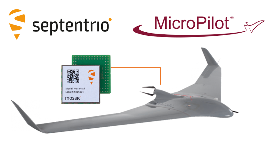
The collaboration ensures smooth and easy integration of high-accuracy GPS/GNSS positioning and professional-level autopilots into control systems where safety and reliability matter
Septentrio is collaborating with MicroPilot, maker of professional UAV autopilots.
Septentrio receivers, including the small form factor mosaic modules, as well as the OEM board AsteRx-m3, will support seamless integration of positioning and orientation into MicroPilot’s autopilot ecosystem.
MicroPilot chose Septentrio GNSS receivers for their resilience to radio interference such as jamming and spoofing, as well as security and robustness with high-accuracy real-time kinematic (RTK) positioning.
Self-interference or self-jamming is a common occurrence in UAVs, where devices such as cameras, servos or antennas, which emit electromagnetic radiation, are located close to the GPS receiver. Incorporating GNSS technology that is resilient to jamming and spoofing, in combination with reliable professional-level autopilots, is key to safe and secure flight navigation, according to Septentrio.
“Adopting new and resilient technology in UAVs is vital, and we want to ensure a smooth integration process into professional drone systems,” said Gustavo Lopez, senior market access manager at Septentrio. “We are very excited about the strong collaboration between Septentrio and MicroPilot, which now provides new alternatives to drone companies looking for safe and reliable flight operations.”
In addition to developing autopilots, MicroPilot provides supporting software and services that enable customers to use development time more efficiently, reducing time to market.
“Working closely with Septentrio gives MicroPilot the ability to better leverage resilient and robust GNSS technologies strengthening our offering to the professional UAV market for safe and reliable flight control,” said Howard Loewen, president of MicroPilot.
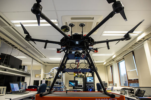
The Navigation Laboratory of the European Space Agency (ESA) has acquired an unmanned aerial vehicle (UAV) that can carry different types of satellite navigation receivers to collect data for follow-on analysis.
The NavLab, based at ESA’s ESTEC technical centre in Noordwijk, the Netherlands, is focused on the testing, analysis and characterization of navigation systems for both ESA and external customers.
With UAVs representing a rapidly expanding user base, the new UAV is a timely addition to the NavLab’s suite of platforms for testing GNSS technologies and techniques, ESA said. Other tools include static, mobile and pedestrian platforms and a pair of test vans.
Along with receivers and antennas, the UAV can host radio-frequency spectrum samplers and support equipment such as inertial sensors and stereo cameras, allowing the assessment of performance in specific dynamics and environments related to UAV applications, such as approach, landing, flying beside buildings or indoors.
Trimble has opened its Call for Speakers for the Trimble Dimensions+ 2022 User Conference to be held November 7-9 at the Venetian Resort in Las Vegas.
The Dimensions+ User Conference will promote a variety of sessions highlighting groundbreaking technology that can be used to transform work and push for a sustainable future. Speakers will have the opportunity to share their industry experiences and insights with peers from around the globe. The conference will also provide an Offsite Experience where attendees can learn how professionals are using the latest technologies to create a safer, greener and more productive work environment.
Session topics will include autonomy; building design, construction and operation; civil engineering and infrastructure; forensics; forestry; local, state and federal government; land administration; mapping and GIS; marine construction; mobile mapping; monitoring; photogrammetry and remote sensing; scanning; surveying; utilities; sustainability and more.
Proposals for speakers will be accepted through March 31, 2022 and notifications of acceptance will be made in the following months. Proposals can be submitted here.
To register for the conference or learn about sponsorship opportunities, visit Trimble’s website.
Spirent Communications plc has chosen Navmatix s.r.o., a Czech-based company that provides cloud infrastructure for real-time data delivery, to provide cloud infrastructure for its GNSS Foresight service.
Spirent GNSS Foresight is a cloud-based service delivering real-time data on the availability and quality of GNSS signals. The solution accurately forecasts when and where GNSS positioning and navigation will be most reliable through a combination of high-definition maps and precise orbital modelling. This makes it possible to obtain a clear picture of the operating environment at a moment’s notice.
GNSS Foresight will ultimately allow unmanned vehicles, air taxis and drones to operate beyond-visual-line-of-sight (BVLOS) safely.
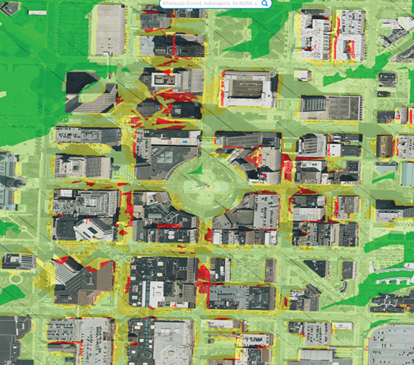
The GNSS Foresight service enables flight in challenging environments by calculating GNSS availability for every meter, every second, from 1-100 meters altitude, for up to three days into the future. (Image: Spirent Communications)
Navmatix will provide the cloud infrastructure required to deliver GNSS forecast data as real-time data via an API. Navmatix will be deploying full operational and developmental support, including hosting for collection and processing the GNSS forecast data through its content delivery network (CDN). The CDN allows the end user to efficiently query, comprehend and interact with the data. Navmatix will handle the foundational infrastructure of the project, a significant phase in expansion of the company as a whole.
“Spirent Communications are pioneers in GNSS test and assurance solutions, and the Spirent GNSS Foresight service expands our solutions to help autonomous systems reliably use GNSS,” said Jeremy Bennington, vic president of PNT Assurance. “Navmatix has built a framework that can deliver mission-critical services, which is also reliable and scalable. We’re excited to be partnering with Navmatix and look forward to growing Navmatix’s CDN to support the growth of Spirent GNSS Foresight solution throughout its complete lifecycle.”
Because of the amount of data generated, the architecture delivers a robust and sophisticated solution, according to Navmatix. Being entirely cloud based, it allows for continual updates and remote access. The cloud infrastructure will provide the tools necessary to deliver Spirent GNSS Foresight services to Spirent customers worldwide.
Navmatix offers managed infrastructure solutions for the operation, development and ongoing maintenance of GNSS services worldwide.
The Avy Aera departs from its docking station within minutes, shortening response times and reducing costs for first responders. (Photo: Avy)
Dutch company Avy has launched its Drone Response Network, combining docking stations with autonomous aircraft that have vertical take-off and landing (VTOL) capabilities.
The network offers drone coverage in a certain area, enabling instant deployment to support medical deliveries or emergency services during critical incidents.
First flights are expected to take place in the first quarter of 2022.
The network uses the Avy Aera autonomous drone that can carry up to 3 kg of medical goods over a distance of 100 km. It can operate year round, in rain and winds up to 45 kph, and is designed to meet the latest European Union drone regulations and United Nation requirements for aerial transport of medical goods.
For medical delivery, the drone is equipped with Aera’s Medkit, which has a four-liter capacity and is fitted with sensors for immediate assessment. Medical products remain cooled at 2-6 degrees for at least 100 minutes in an ambient temperature of up to 40° C.
The Avy Drone Response network is suitable for both urban and rural areas, delivering medicines, blood products, vaccines and other medical applications safer and twice as fast as road transportation, and is more environmentally friendly. It is expected to make a substantial contribution to achieving the goal of connecting hospitals and laboratories by air by 2023.
The Avy Aera can also be integrated with a high zoom RGB and thermal camera system and used to quickly detect wildfires, spot people in distress at sea, monitor oil spills and assess the situation on the ground.
InfiniDome, Honeywell and Easy Aerial have successfully demonstrated their new Robust Navigation System for UAVs. The system integrates GPS anti-jamming technology, a radar velocity system and an inertial navigation system into a resilient system that enables UAVs to safely operate in GNSS-challenged or denied environments.
UAV developers or end users currently try to solve the problem of GNSS jamming either by creating “safe landing protocols” in GNSS-challenged environments or by adding various types of sensors such as lidar or optical. These sensors may not work in certain scenarios, such as when flying too high, too low or too fast; in fog or darkness; or above the ocean.
The Robust Navigation System, jointly developed by Honeywell and infiniDome, tightly pairs the GNSS-based UAV-tailored Honeywell Compact Inertial Navigation System (HCINS) with infiniDome’s GNSS anti-jamming technology (GPSdome), integrated with Honeywell’s Radar-based Velocity System (HRVS). It can be installed on almost any UAV, providing continuous, accurate navigation data in GNSS-challenged or fully GNSS-denied environments.
The companies demonstrated the new navigation system for Israeli defense prime contractors and drone companies and government end-users at a testing range in the center of Israel. The system was tested against two military-grade directional jammers of different types and bandwidths on customized Osprey Hexa-copter with a PixHawk 2.1 Cube Black flight controller. The GPS 1 input was a Here2 standard GNSS receiver and antenna module; the GPS 2 input was the Robust Navigation System (GPSdome 1.03 + HCINS + HRVS).
A customized Osprey Hexa-copter demonstrated the Robust Navigation System. (Photo: InfiniDome)
The goal of the demo was to show that a UAV in a GNSS-challenged environment (single direction of jamming) and fully denied environment (multiple directions of powerful jamming) can perform autonomous tasks accurately and safely without the pilot needing to assume manual control. This included beyond-visual-line-of-sight flights.
Each test was designed to be more difficult than the preceding one and would be executed only if the latter was successful. The intention was to find the barrier at which the system fails.
The first test was maintaining the UAV height (AltHold), position (PosHold) and Loiter autonomously under jamming conditions, followed by a simple point-to-point autonomous task under the same jamming conditions.
The UAV then performed a fully autonomous task including executing a 10-point polygon and returning to the same position accurately under the same jamming conditions. Finally, the UAV was tested for lift-off performance, executing the full polygon and landing under the jamming conditions.
Protected by the Robust Navigation System, the UAV passed all planned tests.
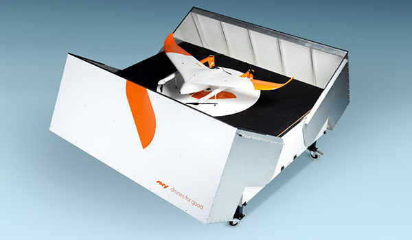
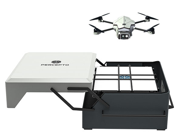
Percepto Air Mobile drone with base. (Photo: Percepto)
Percepto, an Israel-based company specializing in autonomous inspection with industrial robotics, has launched its 2022 Autonomous Inspection & Monitoring (AIM) platform and Air Mobile drone.
Recently listed in TIME magazine’s 100 Best Inventions of 2021, Percepto offers an end-to-end solution powered by artificial intelligence (AI) to collate and streamline all visual data for accurate actionable insights.
Percepto AIM 2022 has a new Insight Manager to deliver AI-powered packaged solutions for sector-specific use cases, such as solar, mining, energy, oil and gas and other industries. The company drew on tens of thousands of hours collected by autonomous robot missions at industrial facilities to create it.
Percepto’s AI change-detection framework offers unified visual data and critical business insights for each of the sector-specific solutions. AIM 2022 can be integrated with autonomous drones and robots as well as other visual data collectors, now including DJI drones, and fixed cameras.
Reports and insights are automatically generated based on the combined visual data. Disseminated to relevant stakeholders on any mobile device, issues and faults are geotagged and displayed on a map, enabling effective action before escalating into more serious problems.
Percepto also introduced its new Percepto Air portfolio to support the enhanced platform, which will address the diverse needs and increasing demands of various markets.
Percepto Air Max. The next generation of Percepto Sparrow, the Percepto Air Max is a field-proven solution that operates in the largest mining, oil and gas, and energy companies on six continents. It has a top-grade, versatile payload for specific use cases. Designed to inspect and map complex industrial environments where the highest accuracy and durability are critical, Air Max also has an optical gas imaging (OGI) camera.
Percepto Air Mobile. This option is a more compact and lighter weight model for smaller sites or organizations taking their first steps with a drone-in-the-box program, or larger sites that need greater deployment flexibility. It is designed for linear inspections, such as pipelines and power lines, and can monitor short-term projects across multiple sites, such as construction sites.
Percepto Air Max and Air Mobile drones are stored permanently onsite within their respective Percepto Bases. The Air Mobile’s base is light and easy to relocate while maintaining high levels of durability. These encasements are designed for infrequent maintenance and protection against extreme environmental phenomena, such as hurricanes. Percepto’s drones are safe and regulation ready, and ensure all operational aspects meet corporate standards.
“Percepto AIM 2022 and the new Percepto Air line of drones, together with the most advanced change detection solution, alert and prevent failures and downtime within diverse use cases across many industries,” said Percepto CEO Dor Abuhasira. “Percepto AIM provides the most advanced and comprehensive enterprise inspection software that offers a complete data workflow — from capture to insight. With Percepto Air Max and Percepto Air Mobile, companies have a range of options to choose from depending on the size of their facilities and the flexibility needed to deploy drones.”
“The real power of Percepto’s system is how data collection and analytics are integrated for a holistic view from both a technical and management perspective,” said Tim Shanfelt, director of Operations Transformation, Koch Ag & Energy. “Our workers are connected to high-level information that helps them make the right decisions while keeping them safe and free to pursue higher value activities. Our goal is to eliminate hazardous, wasteful, and mundane tasks from our operators’ day. For example, instead of an employee climbing an icy ladder in the winter, a robot or drone can perform the same task while still obtaining accurate measurements. We see Percepto playing a significant role in helping make our facilities more safe, secure, efficient, and profitable.”
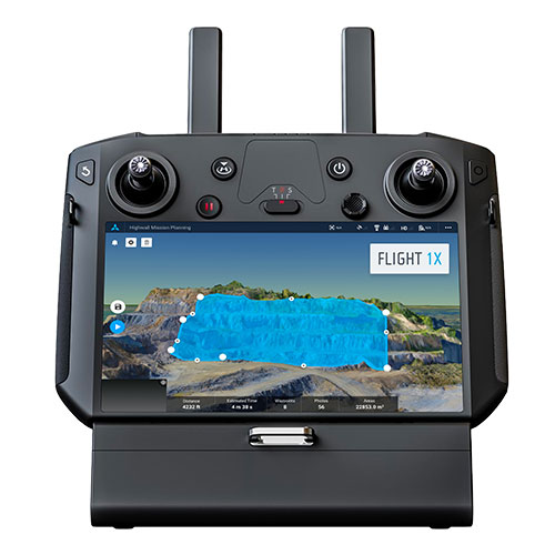
Skycatch is offering new data-capture capabilities for the DJI Matrice 300 through its proprietary Flight1x software — a key component of the company’s High Precision Package.
The High Precision Package provides mining operations with cloud or edge-based data processing that enables viewing terrain in 4D, automated RTK/PPK industrial drone management, and fast edge processing with data visibility in minutes.
Built on technology adopted by companies Komatsu Mining and AngloAmerican, Flight1x outperforms traditional off-the-shelf data mapping tools by including purpose-built flight automation software for the M300, leveraging DJI’s L1 and P1 sensors.
The solution delivers data and network security via Skycatch servers in the United States, coupled with advanced automation features like a 3D first-mission planner, mining-focused workflows and deep integration into Skycatch’s data analytics platform Datahub.
The Flight1x software will work with the M300 to help mining engineers quickly extract data. Features include:
fully automated capture, extraction and processing of high-precision 3D point clouds
highly specialized mission-planning automation to extract data from complex terrains such as high walls
complete industrial data capture and processing for repeatable and automated spot inspection
consistent data-retrieval analysis of thousands of terrain spots in a single location by an automated industrial drone
fully automated aerial robot technology built on Skycatch’s automation platform, eliminating the need for manual pilots and reducing risk of human error.
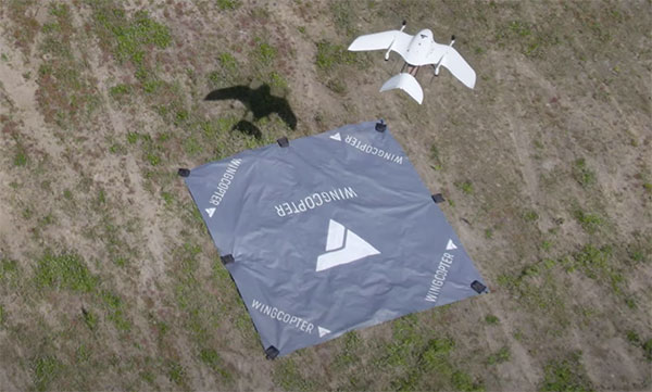
Wingcopter drones recently transported blood samples 26 kilometers (16 miles) between Greifswald and Wolgast, Germany. The flights were carried out by Greifswald University Medical Center in cooperation with DRF Luftrettung and Wingcopter as part of the MV|LIFE|DRONE Challenge (MVLD-Challenge) project of the hospital’s Department of Anesthesiology.
The project, funded by the German Federal Ministry of Health and the Ministry of Energy, Infrastructure and Digitalization of Mecklenburg-West Pomerania, is a partnership between University Medical Center Greifswald and DRF Luftrettung. The goal of the project is to improve structures of regional emergency care by integrating unmanned aerial vehicles (UAS, Unmanned Aerial Systems) into the rescue chain and into medical emergency transports.
The flights beyond the pilots’ visual line of sight (BVLOS) carried a pneumatic tube including 250 grams of blood samples. The Wingcopter completed the 26-kilometer route in an average of 18 minutes, nearly twice as fast as ground-based transport.
The use of Wingcopter drones could significantly speed up emergency medical care in rural areas and help save lives. In the event of a blood transfusion being necessary at short notice, for example, blood samples from Wolgast District Hospital must be transported to Greifswald University Hospital for analysis in order to determine the appropriate donor blood.
“With this project, we have demonstrated that we can also improve medical care and quality of life in rural areas in Germany,” said Ansgar Kadura, co-founder and CSO of Wingcopter. “With our new unmanned aerial vehicle, the Wingcopter 198, this can be carried out even more efficiently in the future. We look forward to continued collaboration with the project team at the Department of Anesthesiology as part of the MV|LIFE|DRONE Challenge and beyond.”
The Greifswald University Medical Center seeks to establish permanent flight connections between the medical center in Greifswald and hospitals in the surrounding area as soon as possible. Drones can also be used to support first responders on site by quickly transporting medications, transfusions or emergency medical equipment such as defibrillators to the scene of an accident.
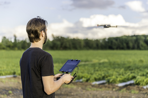
A Canadian drone pilot flies a UAV over a field. (Photo: Onfokus/iStock/Getty Images Plus/Getty Images)
360iSR and Canadian UAVs have agreed to jointly offer comprehensive unmanned aircraft system (UAS) operations training on the market globally.
The joint training offering leverages the partnership’s detect-and-avoid technology, which is available for multiple platforms and approved by Transport Canada, a branch of the Canadian government. The center will provide end-to-end UAS training solutions in alignment with NATO Standard ATP-3.3.8.1 requirements.
The initiative will provide access to comprehensive UAS operations training in these areas:
operational airworthiness
airmanship
general UAS information
detect-and-avoid systems and procedures
the integration of UAS in non-segregated airspace
intelligence, surveillance and reconnaissance (ISR) procedures.
Canadian UAVs is a Transport Canada registered training company with a proven track record providing UAV training to the Department of National Defense. The company has highly qualified UAS personnel who hold Transport Canada Advanced small RPAS Pilot Certificates (including those with Flight Reviewer ratings) and is authorized to provide beyond-visual-line-of-sight (BVLOS) UAS Operations Training at Foremost UAS Test Range in Foremost, Alberta, Canada.
360iSR offers end-to-end ISR support with an experienced team to deliver all aspects of ISR. 360iSR has worked on projects ranging from counter-poaching in Southern Africa to large-scale security events such as the London Olympic Games.
Spirent GNSS Foresight predicts where and when unmanned vehicles, air taxis and drones can operate safely and dependably beyond visual line of sight
Spirent Communications plc has launched Spirent GNSS Foresight, a cloud-based solution that lets operators know in advance where and when GPS or GNSS positioning is reliable for unmanned and autonomous journeys.
GNSS Foresight accurately predicts where and when unmanned vehicles, air taxis and drones can operate safely and dependably beyond visual line of sight (BVLOS), especially in urban areas where buildings frequently obstruct GNSS signals.
The service addresses a key issue facing developers and operators of unmanned aerial systems (UAS) and autonomous vehicles. Because GNSS performance can be unpredictable in urban and suburban areas from signals being obscured or blocked by buildings, autonomous systems have not been able to rely on GNSS for accurate positioning.
GNSS Foresight will be shown publicly for the first time at ION GNSS+ 2021 in St. Louis, Missouri (Sept. 22–24).
“Accurate, reliable GNSS performance is a key enabler of game-changing innovations that are shaping our future — autonomous drones, air taxis, cars and trucks,” said Spirent’s vice president of PNT Assurance, Jeremy Bennington. “GNSS Foresight overcomes navigation and positioning challenges by providing real-world situational awareness ahead of time for pre-flight, or for real-time performance improvement, through a cloud-based service. It can be used to determine areas that are always safe to fly or operate in, in addition to finding the exact time in a degraded area when specific operational requirements can be met. GNSS Foresight enables operators to enhance efficiency, safety and ROI through the resulting operational improvements.”
Spirent GNSS Foresight’s ability to accurately predict where and when autonomous systems will perform enables users to scale operations or services by expanding operational areas, reducing the number of system disengagements, and providing a greater level of safety and reliability assurance when reducing — or ultimately removing — human involvement in the driving or piloting task.
GNSS Foresight can produce forecasts using data from any of the world’s satellite constellations, and is of particular interest to the aviation and UAS sector, as well as the automotive industry. It will be shown publicly for the first time at ION GNSS+ in St Louis (Sept. 22–24).