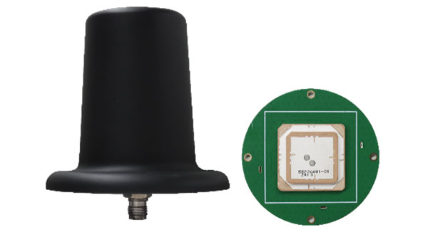
Harxon has introduced a new line of smart antennas that seamlessly integrate advanced antenna technology with a comprehensive real-time kinematic (RTK) positioning module. These products offer high-precision positioning capabilities within a compact and easily integrable form factor, making them ideal for various applications.
The smart antennas incorporate full-constellation, full-frequency RTK positioning modules, enabling a range of accuracy levels to suit different needs. Users can achieve single-point meter-level accuracy, DGPS sub-meter-level accuracy or RTK centimeter/millimeter-level accuracy depending on their requirements.
The series includes both housed and embedded versions tailored for specific use cases. The HX-MR401A and HX-MR402A are housed versions, while the HX-ME403A and HX-ME404A are embedded versions designed for UAVs. These models leverage Harxon’s low-profile helix antenna technology. For robotic lawnmowers, Harxon offers the HX-ME401A and HX-ME402A, which are based on the cost-effective and high-performance OEM GNSS Antenna HX-CSX231A26.
Photo: Harxon
OEM GNSS antenna
Harxon has expanded its OEM GNSS antenna lineup with two combined antennas: the HX-SE402A and HX-SE403A. These full-band, full-frequency antennas integrate GNSS capabilities with a low-profile radio antenna that supports the 858-878MHz and 902-928MHz frequency bands. This addresses the growing need for devices requiring both navigation and communication functionalities.
Unlike traditional whip-shaped radio antennas, which can extend up to 20 cm, Harxon’s new low-profile technology achieves the same functionality at 10 mm height, which allows for greater versatility in applications that demand precise positioning alongside wireless communication. Additionally, Harxon offers custom tuning services to optimize integration into OEM end-user modules for specific applications.
Photo: Harxon
Anti-jamming GNSS antenna
Harxon has introduced its inaugural series of anti-jamming antennas, starting with two initial models: PT023 and PT024. These GNSS antennas are specifically engineered to operate in challenging environments characterized by complex electromagnetic interference, high-power signals and strong multipath effects.
They are well-suited for scenarios involving low-elevation angle interference, high-power interference sources and radio communication system noise. The PT023 model utilizes multiple array elements combined with amplitude and phase manipulation to achieve spatial radiation shaping. This antenna also incorporates advanced multi-level filtering technology, effectively suppressing out-of-band noise power.
In contrast, the PT024 model features vertical and horizontal two-dimensional polarization suppressors. This design effectively mitigates the reception of both odd and even LHCP and RHCP signals originating from the rear of the antenna, according to the company. It can also suppress low-elevation multipath signals at the same frequency and out-of-band noise signals. These features collectively enhance the antenna’s performance in complex electromagnetic environments.
Honeywell has unveiled its resilient embedded GPS/inertial navigation system (EGI), designed to address the evolving challenges of modern warfare and meet U.S. government mandates for greater power competition. This navigation system integrates GPS and inertial navigation technologies to deliver precise position, velocity and timing information for various applications.
Expanding on Honeywell’s H-764 and FALCN, the EGI is specifically designed to fulfill military needs in areas where GPS jamming and spoofing are prominent. The system includes M-code capability, an atomic clock and open architecture compliance, allowing crucial mission flexibility with alternative positioning, navigation and timing (PNT) forms.
It allows for the seamless integration of various alternative PNT sources, including vision navigation, celestial navigation and magnetic navigation for continuous and accurate navigation even in the face of GPS threats.
Honeywell plans to make engineering units of this EGI available in early 2026, with certifiable units following shortly after. The company said this timeline allows for thorough testing and refinement, ensuring the system meets the reliability and performance required for critical military applications.
The United Kingdom’s Ministry of Defence (MOD) is focusing its alternative positioning, navigation and timing (Alt PNT) project on deployable eLoran. This comes after industry days for Alt PNT in March and June 2024.
The announcement came in a Request for Information (RFI) on Sept. 20. It specifies that a contract will be let for the development of a deployable eLoran network. As part of that contract, the MOD also wants to develop:
A modelling capability, which will allow for theoretical analysis of capabilities and informing the concept of employment.
An assured capability within the Loran Data Channel
Information and demonstration of the resulting capability to stakeholders
UK PNT Policy Framework
Last year, the UK government announced a ten-point “policy framework” for advancing the nation’s PNT resilience. One of the ten points is:
“Develop a proposal for a resilient, terrestrial, and sovereign Enhanced Long-Range Navigation (eLORAN) system to provide backup position and navigation.”
Most have seen this as a provision for a fixed domestic system for use by critical infrastructure and applications. The UK already has an on-air single eLoran transmitter that provides a timing signal. An announcement about establishing two or more additional transmitters to provide PNT services for the British Isles and their adjacent waters has been anticipated.
The policy framework also includes:
“Develop a proposal for ‘MOD Time’ creating deeper resilience through a system of last resort and use NTC-provided timing to support MOD.” [NTC stands for National Timing Centre.]
It is not immediately clear how this RFI from the MOD fits these two provisions, if at all, or is entirely separate.
1970s Deployable Loran
Deployable Loran, or Loran-D was first developed for the U.S. Air Force in the 1970’s. An oral history recounts that a system was deployed early in the 70’s by the 6514th Test Squadron at the Utah Test and Training Range (UTTR), a component of Hill Air Force Base. It was built by Megapulse, employed a Hewlett Packard beam clock and 150 ft antennas, and was used for testing unmanned aircraft. There are also indications elsewhere that the Air Force used it for precision bombing.
Industry sources say that this earlier work provides a solid foundation for developing future deployable eLoran systems.
UK MOD Requirements
The RFI is fairly specific about the questions it wants answered. These requirements look nearly ready to be transformed into a Request for Proposal and contract language. They include:
The demonstrator system shall include a minimum of 3 transmitters to enable a suitable receiver to live demonstrate position and time determination from the system.
Across the coverage area, the system shall transmit a signal that allows receivers to achieve position and timing accuracy in line with the needs of defense platforms (which have not yet been specified).
The system shall be able to operate with and without GNSS access.
The system shall be able to operate both with and without access to eLoran signals from eLoran transmitters outside the deployable system’s group.
The system shall be capable of maintaining performance & accuracy for prolonged periods, including without access to eLoran and GNSS signals.
The system shall be able to be contained and transported in an ISO container.
The system shall be able to be assembled, initialized and disassembled by as small a team as possible.
Respondents must submit by the 18th of October to be considered.
The increasing prevalence of GNSS spoofing in commercial aviation poses significant safety concerns and highlights the need for robust alternative positioning, navigation and timing (A-PNT) sources. This form of electronic warfare, which uses fake signals to confuse aircraft navigation and safety systems, has become a growing issue for civilian flights worldwide.
Pilots told The Wall Street Journal that spoofing incidents have risen in recent months. According to analyses from SkAI Data Services and the Zurich University of Applied Sciences, the number of affected flights per day increased from a few dozen in February to more than 1,100 in August 2024.
The issue of spoofing has expanded beyond active conflict zones near Ukraine and the Middle East, and now affects hundreds of civilian pilots daily on a global scale. The modern cockpit’s heavy reliance on GPS technology means that falsified data can have far-reaching consequences, breaching multiple aircraft systems and causing disruptions that may last anywhere from a few minutes to an entire flight.
According to anonymized reports shared with government agencies and industry groups, pilots have experienced many alarming incidents, including sudden clock resets, false terrain warnings and unexpected flight path deviations. This surge in GNSS spoofing attacks highlights the vulnerability of critical navigation systems and raises significant concerns about aviation safety in an increasingly complex environment.
All jammed up The Wall Street Journal reported that in August 2024, a United Airlines flight from New Delhi to the New York area encountered a GPS spoofing incident that affected its navigation systems for the duration of the flight.
Initially, the flight seemed to adhere to the standard GPS route across Asia, mirroring the path taken by previous flights heading to Newark Liberty International Airport. The spoofing attack, originating in the Black Sea region south of Ukraine, caused the aircraft’s GPS coordinates to deviate progressively from its actual position throughout the remainder of the flight.
Even after the plane had left the affected area, its reported GPS location continued to show erratic behavior, occasionally making sudden jumps. This suggested that the navigation equipment was struggling to recalibrate accurately. While alternative navigation systems ensured the flight’s safe completion of its intended route, the compromised GPS data indicated that it had terminated in the Atlantic Ocean. In reality, the aircraft landed safely at its scheduled destination in Newark.
Keeping operations safe Aviation safety officials said spoofing has disrupted some flights but has not posed major safety risks. Pilots are trained to use A-PNT systems as backups. However, managing false GNSS signals and alerts risks dividing the operator’s attention if a more severe problem arises.
“If we lose an airplane because of workload issues because of these problems we’re encountering, compounded with an emergency, that is going to be a horrendous event,” said Ken Alexander, the Federal Aviation Administration’s chief scientist for satellite navigation, during a pilot union forum in Washington, D.C.
Airlines are collaborating with aircraft manufacturers, parts suppliers, and aviation safety authorities to devise immediate solutions and long-term strategies. For example, the International Air Transport Association (IATA) and the European Union Aviation Safety Agency (EASA) are openly discussing these challenges and holding workshops to share best practices. Safety bulletins have also been issued for operations where spoofing and jamming are known to have occurred.
Industry insiders told The Wall Street Journal that the development of new equipment standards to enhance civilian aircraft resilience against spoofing attacks is not expected to be finalized until 2025.
Navigating issues across sectors According to anonymized reports collected by OpsGroup, an aviation safety organization that includes pilots, dispatchers and other airline staff, various attacks have caused navigation issues across multiple sectors.
GNSS spoofing has disrupted operations in Europe but has not endangered flights, said Florian Guillermet, executive director of the European Union Aviation Safety Agency. Pilots had to divert to airports they did not intend to land at, and earlier this year, an airline temporarily halted operations at an Estonian airport that was not equipped with ground-based navigation as a backup for GNSS.
Boeing said manufacturers, carriers and regulators globally are contributing GPS expertise for solutions to ensure safety. Boeing and Airbus are working with airlines to help develop procedures to assist pilots, the companies said.
United and American said their pilots are equipped with several ways to navigate with precision, even with GPS interference. American said it has not experienced disruptions or significant safety concerns from GPS interference.
Insights from industry experts
During the 64th Civil GPS Service Interface Committee Meeting — hosted at ION GNSS+ 2024 from Sept. 16-17 — The presentation “Complementing GNSS for Resilient Performance Based Navigation” by Okuary Osechas Ph.D., and Gary A. McGraw, Ph.D., addressed the critical role of complementary positioning, navigation and timing (CPNT) technologies in aviation, particularly in light of increasing threats to GNSS.
The presentation highlights the impact of radio frequency interference (RFI) on aviation, including jamming and spoofing. These pose significant risks to aviation safety by reducing operational margins. The prevalence of these threats is increasing, necessitating alternative navigation solutions.
Performance-based navigation (PBN) is essential for modern aviation, enhancing efficiency and flexibility. However, it relies heavily on GNSS, making it vulnerable to disruptions, again highlighting the need for CPNT services.
Integrating CPNT sources ensures resilient navigation capabilities. This includes leveraging legacy navigation aids and modernized terrestrial systems. Various complementary technologies such as eDME, eLORAN, LDACS-NAV and LEO SATNAV are being assessed for their operational effectiveness, compatibility and potential to support aviation needs.
The researchers recommend the following to address these challenges:
Near-term solutions: Implementing eDME for backward compatibility. Medium-term strategies: Utilizing eLORAN for wide-area time distribution. Long-term goals: Developing LDACS-NAV to enhance spectrum efficiency and standardization. Collaborative efforts: The presentation calls for international cooperation in research and development to advance standards and infrastructure investments in complementary PNT technologies.
SiTime has launched the Endura Low Phase Noise Super-TCXO time synchronization and RF systems designed for high-performance applications requiring stability and low noise in challenging environments.
These devices operate within a frequency range of 10 to 220 MHz and offer frequency stability, with specifications as tight as ±0.1 ppm over a temperature range of -40°C to 105°C. Their phase noise performance can achieve -159 dBc/Hz at a 10 kHz offset for a 19.2 MHz carrier frequency and reach -172 dBc/Hz for broad base phase noise.
The Endura Super-TCXOs exhibit an acceleration sensitivity of 0.01 ppb/g and can withstand shocks up to 30,000g and vibrations up to 70g, making them suitable for demanding applications.
These Super-TCXOs are ideal for various applications, including time synchronization and RF systems, aerospace and defense networking, communication systems and positioning, navigation and timing (PNT) applications.
OneWeb Technologies has launched Astra, which is designed to maintain low-Earth orbit (LEO) SATCOM connectivity in GNSS-compromised environments.
The package includes a software-defined outdoor receiver that leverages assured positioning, navigation and timing (A-PNT) broadcast services, significantly enhancing connectivity resilience. Astra can process PNT signals from GNSS and alternative sources across multiple frequency bands to offer continuous connectivity and situational awareness, even in challenging spectrum-contested environments.
The system is compatible with non-GNSS A-PNT broadcast services, such as Iridium. It can identify the optimal PNT source while producing an output signal compatible with the standard GPS L1 interface. In addition to its commercial applications, Astra aligns with the military’s Primary, Alternate, Contingency, Emergency (PACE) communications plan.
Advanced Navigation, Hanwha Aerospace and Hanwha Defense Australia (HDA) have signed a memorandum of understanding (MoU) to co-develop strategic grade assured positioning navigation and timing (APNT) solutions.
Under the agreement, the three companies will collaborate on the development of high-performance inertial navigation systems (INS) for autonomous, airborne, and crewed systems. These systems will be used for precision targeting and vehicle navigation in GNSS-contested environments across land and air domains.
The co-developed solutions will be integrated into Hanwha Aerospace’s global supply chain to advance the broader strategic APNT interests for Australia and international markets.
By integrating Advanced Navigation’s IP in digital fiber-optic gyroscope (DFOG) technologies with Hanwha’s robust aerospace and defense capabilities, the agreement seeks to augment Australia’s manufacturing and supply chain resilience to meet the demand of global military supply chains.
Hanwha Defense Australia’s Armoured Vehicle Centre of Excellence (H-ACE) in Melbourne, Australia, will provide critical facilities supporting the production and sustainment of tracked armored vehicles, including multiple assembly lines, a 1,200 m test track, a deep-water test facility, an obstacle course and a research and development center. Stage 2 of the development will also include Australia’s EMI/EMC (electromagnetic interference/compatibility) chamber and test shooting tunnel alongside an expanded manufacturing capability.
In the neighboring state of New South Wales, Advanced Navigation’s manufacturing facility will be used for the secure production of APNT solutions. Specifically, it enhances the critical output of strategic-grade DFOGs, which possess the heightened sensitivity necessary to detect the Earth’s rotation.
Skylark Labs has released the Aerial Reconnaissance and Elimination System (ARIES), designed to enhance situational awareness and counter emerging threats.
ARIES utilizes artificial intelligence (AI) to detect, classify and respond to threats in real-time. The system’s AI continuously adapts to new threats across multiple domains without requiring manual updates to improve situational awareness and accelerate decision-making for military personnel.
The system can detect and track UAVs beyond visual line of sight (BVLOS). This capability extends the range and effectiveness of counter-unmanned aerial system (C-UAS) operations, providing early warning and enabling rapid response to potential threats.
ARIES seamlessly integrates with existing defense infrastructure, which eliminates the need for frequent manual system updates and seeks to improve overall mission success rates.
The system has been successfully demonstrated to key Department of Defense (DOD) stakeholders, showcasing its potential to enhance counter-UAS operations. During the demonstration, ARIES offered critical, real-time intelligence for swift decision-making in response to UAV incursions.
JammerTest in Bleik, Andøya, Norway. (Photo: David Jensen)
GNSS jamming trials have begun on the Island of Andøya in Northwestern Norway as part of Jammertest 2024. This event features both simple and sophisticated staged spoofing and jamming attacks, allowing participants to identify potential strengths and weaknesses in their GNSS-based systems.
The increasing frequency of jamming and spoofing incidents, particularly affecting Northern Norway and possibly linked to Russian activities, drives the demand for more resistant GNSS and non-GNSS-based contingency systems. In response, the Norwegian Defense Ministry has called for the development of alternative means of positioning, navigation, and timing (PNT) provisions to protect against GNSS jamming in maritime navigation.
During Jammertest 2024, researchers from both public and private sectors are assessing how effectively existing and new technology systems can withstand jamming and spoofing attacks in real-world scenarios. One of the staged jamming attacks, taking place from Sept. 4-13, 2024, is occurring on two stretches of road near Bleik, a small coastal town on Andøya Island. This trial was approved by Norway’s National Communications Authority and is being carried out by the Public Roads Administration, Defense Research Institute, Norwegian Space Center, and other partners.
Later in September 2024, the Defense Research Institute will conduct military jamming tests on Andøya, focusing on operational testing of military weapons systems and loss of GPS signals. Local inhabitants have been notified that they may experience relatively short-lived GNSS disruption during these trials, most of which will involve GPS jamming but not spoofing or meaconing.This year marks the third consecutive year that Jammertest is being held on Andøya, which is also the site of Norway’s Andøya Space Center.
The event has garnered record-high interest worldwide, with more than 300 applicants for Jammertest 2024. During the 2023 edition, 264 comprehensive tests were conducted, exploring various topics such as sensor fusion, radio frequency interference (RFI) countermeasures, and combinations of GNSS with alternative positioning, navigation and timing (PNT) solutions
Furuno will participate in Jammertest 2024 in Andøya, Norway, from Sept. 9 to 13, 2024. This event is widely recognized as the world’s largest GNSS resilience testing event, providing a unique opportunity for companies to evaluate their GNSS receivers in real-world environments.
Jammertest 2024 will expose participants’ GNSS receivers to jamming and spoofing signals, allowing companies to gather valuable data on their product tolerance levels. The event is organized by several Norwegian institutions, including the Norwegian Public Roads Administration, Norwegian Communications Authority and Norwegian Space Agency.
Furuno will be testing its GT-100 timing multi-GNSS receiver module at the event. This module supports dual-frequency band reception in the L1 and L5 bands, making it suitable for critical infrastructure applications such as 5G mobile base stations, TV broadcasting and power grids.
GT-100. (Photo: Furuno)
Key Features of GT-100:
Automatic mitigation of jamming and spoofing signals.
Real-time notification of jamming signal frequency and strength.
Ability to maintain L5 band signal reception if L1 band is lost.
By participating in Jammertest 2024, Furuno aims to evaluate and analyze the GT-100’s resistance to jamming and spoofing in real-world conditions. The company plans to use the results further to enhance the robustness of its GNSS receiver technology, ultimately contributing to more resilient critical infrastructure systems.
The UK Ministry of Defence will construct a new anti-jamming test facility at Boscombe Down in Wiltshire, England. This facility is designed to safeguard military equipment from threats posed by GPS jamming. A £20 million ($26 million) contract has been awarded to the defense technology firm QinetiQ, which will create one of Europe’s largest anechoic chambers, set to be operational by 2026.
This facility, referred to as a “silent hangar,” will accommodate large military assets such as Protector UAVs, Chinook helicopters and F-35 fighter jets, allowing for comprehensive testing against electronic warfare threats. Maria Eagle, the minister for defense procurement and industry, said that this facility will help eliminate vulnerabilities in military systems, thereby enhancing national security and better protecting armed forces during global deployments.
The hangar will be engineered to minimize radio-frequency wave leakage, ensuring that testing does not interfere with local emergency services and air traffic control. Additionally, according to the UK Ministry of Defence, the project is expected to generate 20 new jobs in the Boscombe Down area and will support broader applications beyond defense, benefiting various sectors of government and industry.
TrustPoint has secured two Direct-to-Phase II contracts from SpaceWERX, totaling $3.8 million, to advance its GPS-independent ground control segment and develop an advanced positioning, navigation, and timing (PNT) security application. The application is designed to address critical challenges within the Department of the Air Force (DAF) and strengthen the United States’ national defense.
The Air Force Research Laboratory (AFRL) and SpaceWERX, the innovation arm of the U.S. Space Force and a division within AFWERX, have partnered to streamline the Small Business Innovation Research (SBIR) and Small Business Technology Transfer (STTR) processes. Their efforts focus on accelerating proposal-to-award timelines, expanding opportunities for small businesses and reducing bureaucratic overhead through continuous process improvements.
In 2018, the DAF introduced the Open Topic SBIR/STTR program to broaden its funds’ range of innovations. This initiative has paved the way for companies like TrustPoint to develop innovative capabilities contributing to national defense.
TrustPoint is developing a commercial GPS service using a C-Band low-earth orbit (LEO) satellite constellation. The system is designed to offer the high performance, security and availability required for autonomous navigation, critical infrastructure and national security.