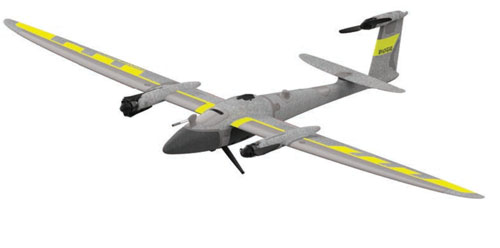
Furuno Electric and Xona Space Systems have signed a Memorandum of Understanding (MoU) to collaborate on solutions using Xona Pulsar, a low-Earth-orbit positioning, navigation and timing (LEO PNT) service for next-generation satellite navigation.
Through the agreement, both companies will leverage their respective technological expertise and business strengths to explore opportunities for delivering advanced and promising LEO PNT solutions.
Furuno has been actively pursuing LEO PNT as a promising technology capable of complementing or even substituting for GNSS.
LEO PNT refers to systems that use a satellite constellation of 200 to 400 satellites deployed in low Earth orbit at an altitude of 500 km to 2,000 km. The LEO constellation is designed for PNT rather than non-terrestrial networks to provide global positioning and timing services similar to GNSS, but with significantly better performance.
Xona is a pioneer in LEO PNT technology and offers a commercial service called Pulsar, which uses a dedicated LEO PNT constellation of 258 satellites. Compared to conventional GNSS, this service enhances resiliency and improves the accuracy of positioning and timing — the proximity of LEO satellites to Earth makes their signal power about 100 times stronger.
Pulsar adopts a signal architecture similar to GNSS for compatibility, making it easy to integrate into existing GNSS products. Integrating Xona Pulsar into Furuno’s products will provide an alternative to GNSS while significantly boosting performance by complementing existing GNSS services.
Furuno’s Pulsar-enabled timing solutions allow users to maintain accurate synchronization even when GNSS is degraded due to unexpected failures, including jamming and spoofing, the companies said.
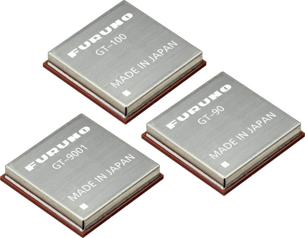
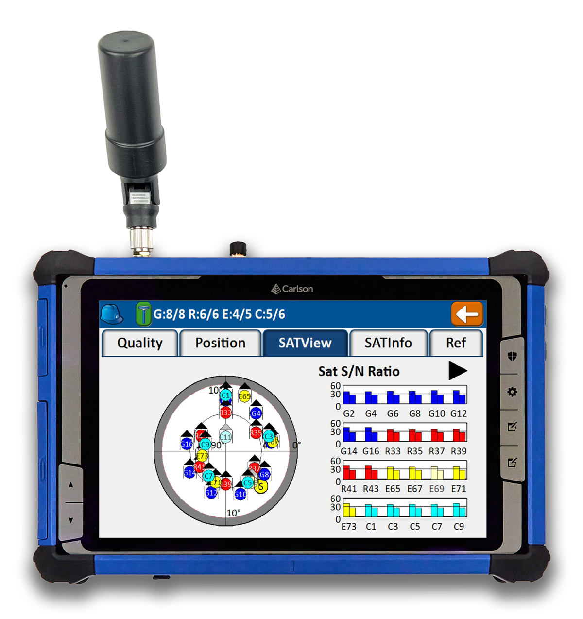
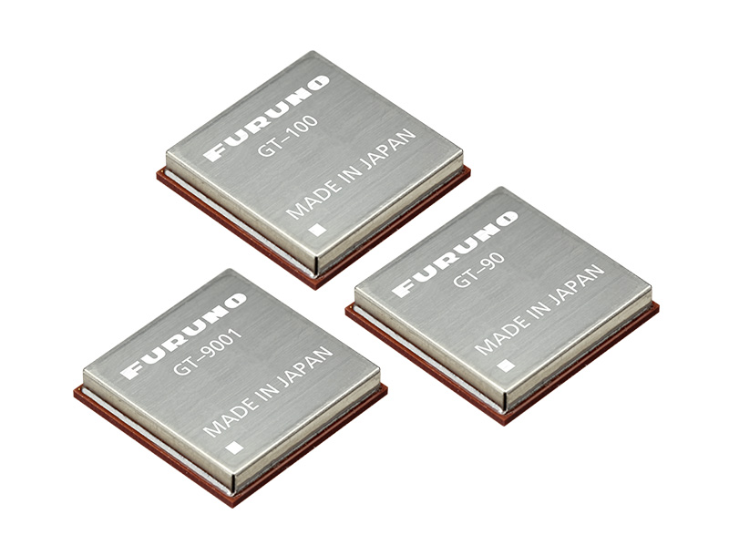
Furuno will begin providing new firmware for its GNSS receivers for time synchronization, including models GT-100, GT-90 and GT-9001, which adds authentication features (OSNMA/QZNMA) and significantly strengthens anti-jamming and anti-spoofing measures.
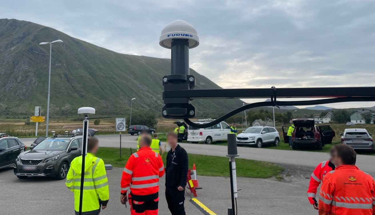
In fields that support critical infrastructure such as telecommunications, finance and power, GNSS vulnerabilities have become a major issue. The Furuno team participated in Jammertest 2025, the world’s largest GNSS resilience testing event. Jammertest 2025 took place in Norway, and verified robustness and reliability under real attack conditions to meet the requirements of critical infrastructure.
Features of the new firmware
The GT-100, GT-9001 and GT-90 modules. (Photo: Furuno)
Addition of authentication functions (OSNMA/QZNMA): Authentication messages from Galileo (European GNSS) and QZSS (Japan’s Quasi-Zenith Satellite System) confirm the authenticity of navigation messages, strengthening resistance to spoofing attacks.
Enhanced anti-jamming and anti-spoofing measures: Detect and eliminate various interference signals with high precision, ensuring stable time synchronization.
Removal of altitude restrictions, enabling use in the stratosphere and similar environments
Addition of TAI (International Atomic Time) output function
Support for multiple data formats (RTCM10403.3, RINEX4.1, binary)
Availability For existing users: Provided as a firmware update.
For new shipments: GT-100, GT-90 and GT-9001 with the new firmware are scheduled to ship beginning in March 2026.
Related product information Furuno has also launched the GNSS Surge Protector, TVA-05V for GNSS antennas. This product protects GNSS receivers from surges caused by lightning, further enhancing the stable operation of critical infrastructure.
In Jammertest 2024, challenges were identified using GT-100; in Jammertest 2025, improvements were validated with the upgraded version, confirming the effectiveness of the resilience algorithms under operational conditions.
Furuno will participate in Jammertest 2024 in Andøya, Norway, from Sept. 9 to 13, 2024. This event is widely recognized as the world’s largest GNSS resilience testing event, providing a unique opportunity for companies to evaluate their GNSS receivers in real-world environments.
Jammertest 2024 will expose participants’ GNSS receivers to jamming and spoofing signals, allowing companies to gather valuable data on their product tolerance levels. The event is organized by several Norwegian institutions, including the Norwegian Public Roads Administration, Norwegian Communications Authority and Norwegian Space Agency.
Furuno will be testing its GT-100 timing multi-GNSS receiver module at the event. This module supports dual-frequency band reception in the L1 and L5 bands, making it suitable for critical infrastructure applications such as 5G mobile base stations, TV broadcasting and power grids.
GT-100. (Photo: Furuno)
Key Features of GT-100:
Automatic mitigation of jamming and spoofing signals.
Real-time notification of jamming signal frequency and strength.
Ability to maintain L5 band signal reception if L1 band is lost.
By participating in Jammertest 2024, Furuno aims to evaluate and analyze the GT-100’s resistance to jamming and spoofing in real-world conditions. The company plans to use the results further to enhance the robustness of its GNSS receiver technology, ultimately contributing to more resilient critical infrastructure systems.
A roundup of recent products in the GNSS and inertial positioning industry from the January 2024 issue of GPS World magazine.
SURVEYING & MAPPING
Laser Scanning Measurement System Compatible with specialized kits
The LS300 3D laser scanning measurement system utilizes simultaneous localization and mapping (SLAM) technology and advanced real-time mapping techniques. The LS300 3D operates autonomously, independent of GNSS positioning, making it ideal for harsh conditions in both indoor and outdoor environments.
LS300 includes a 120-meter working range and a sampling rate of 0.32 million points per second. Its point cloud accuracy is designed to perform in low reflectivity extended-range mode. The system is compatible with specialized kits, including the handheld form, back kit, car mount, and UAV kit.
By using data processing software specifically designed and developed for the LS series, users can handle large volumes of point cloud data and simplify complex tasks, including point cloud denoising, point cloud splicing, shadow rendering, coordinate transformation, automatic horizontal plane fitting, automatic point cloud data report generation, forward photography, and point cloud encapsulation.
During data post-processing, users can input absolute coordinates of control points, allowing these control points to adjust the data and improve scanning data accuracy. The LS300 incorporates a redundant battery design with two hot-swappable batteries, designed to prolong operation without frequent charging or interruptions. ComNav Technology, comnavtech.com
Anti-jamming receiver A jamming protector for legacy receivers
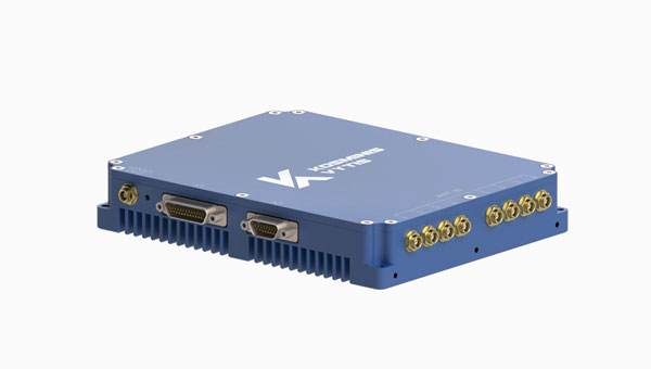
The KV-AJ3 tri-band anti-jamming receiver combines a digital antenna control unit (DACU) and a GNSS receiver. KV-AJ3 can be used as a jamming protector for legacy receivers or as a stand-alone GNSS receiver solution.
The tri-band solution decreases interferences from up to three directions in three frequency bands, including S-band. This approach is designed to provide significantly higher protection against interference compared to single-frequency devices.
The receiver has a digital port for navigation data output. Jamming-free RF signals can also be delivered to external non-protected GNSS receivers to obtain position, velocity, and time.
KV-AJ3 contains a MEMS inertial sensor, which allows for GNSS-aided INS solutions where coordinates and attitude angles are required. Kosminis Vytis, kosminis-vytis.lt
Lidar sensor Designed for high-speed airborne missions
The VUX-180-24 offers a field of view of 75º and a pulse repetition rate of up to 2.4 MHz. These features – in combination with an increased scan speed of up to 800 lines per second – which makes the VUX-180-24 suitable for high-speed surveying missions and applications where an optimal line and point distribution is required.
Typical applications include mapping and monitoring of critical infrastructure such as power lines, railway tracks, pipelines, and runways. The VUX-180-24 provides mechanical and electrical interfaces for IMU/GNSS integration and up to five external cameras.
This sensor can be coupled with RIEGL’s VUX-120, VU-160, and VUX-240 series UAVs. The system is available as a stand-alone sensor or in various fully integrated laser scanning system configurations with IMU/GNSS systems and optional cameras. RIEGL, riegl.com
UAV detection technology A 3D data fusion engine for complex environments
SensorFusionAI (SFAI) is a sensor-agnostic, 3D data fusion engine for complex environments. It accommodates all common UAV detection modalities, including radiofrequency, radar, acoustics, and cameras.
SFAI allows third-party C2 manufacturers to integrate SFAI into its C2 systems. This integration can be achieved through a subscription-based software-as-a-service (SaaS) model, enhancing system performance.
Key features of SFAI include behavior analysis to track an object to determine classification and predict trajectory; threat assessment that determines threat level based on a range of data types; and an edge processing device called SmartHub for reduced network load and high scalability. DroneShield, droneshield.com
Thermal mapping solution Designed for UAVs
The PT61 camera is a thermal mapping solution for UAVs. The camera system provides detailed thermal orthomosaic maps and accurate 3D models. Developed in partnership with Agrowing, the PT61 is a versatile tool designed for multispectral data collection in renewable energy and other domains.
The PT61 combines a 61-megapixel camera with integrated thermal imaging capability. It can also switch between RGB and multispectral modes, which aims to increase its versatility and address the increasing need for comprehensive data acquisition in various industrial and environmental applications.
Integrated with Agrowing’s multispectral lenses, the camera offers detail across 10 spectral bands and an infrared band, making it ideal for solar plant inspection and dam management.
The enhanced Topodrone post-processing software complements the hardware by streamlining remote sensing tasks, ensuring surveyors and researchers can achieve high levels of efficiency. Topodrone, topodrone.com
OEM
Dual-band GNSS receiver Achieves 50cm position accuracy without correction data
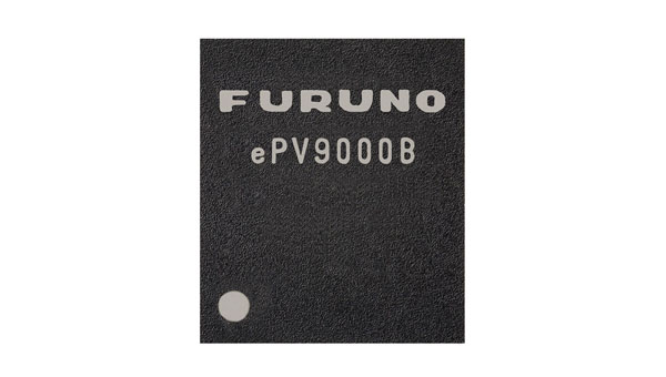
eRideOPUS 9 is a dual-band GNSS receiver chip that achieves 50cm position accuracy without correction data. eRideOPUS 9 is designed to provide absolute position information and can be used as a reference for lane identification, which is essential for services such as autonomous driving. It also serves as a reference for determining the final self-position through cameras, lidar, and HD maps.
The eRideOPUS 9 supports all navigation satellite systems currently in operation, including GPS, GLONASS, Galileo, BeiDou, QZSS, and NavIC. It can also receive L1 and L5 signals. The L5 band signals are transmitted at a chipping rate 10 times higher than L1 signals, which improves positioning accuracy in environments where radio waves are reflected or diffracted by structures, such as in urban areas — a phenomenon known as multipath.
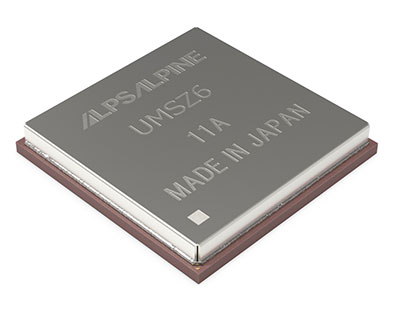
A dual-band GNSS module incorporating eRideOPUS 9 is being jointly developed with Alps Alpine Co. and is scheduled for future release as the UMSZ6 series. Furuno Electric Co., Furunousa.com
Lidar scanning module Designed for OEM integration
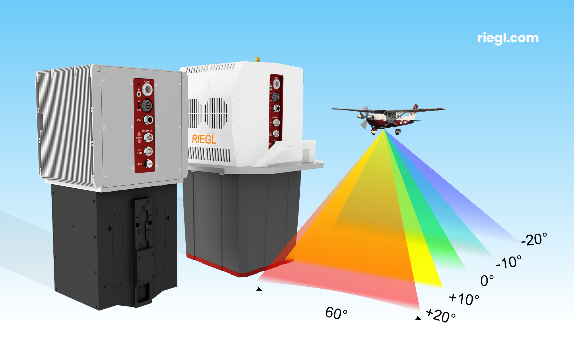
The VQ-680 compact airborne lidar scanner OEM is designed to be integrated with large-format cameras or other sensors in complex hybrid system solutions.
It can be mounted inside a camera system connected to the IMU/GNSS system and various camera modules through a sturdy mechanical interface. The VQ-680 has laser pulse repetition rates of up to 2.4 MHz and 2 million measurements per second.
The VQ-680 is ideal for large-scale applications in urban mapping, forestry, and power line surveying. With a field view of 60º and RIEGL’s nadir/forward/backward (NFB) scanning, the system offers five scan directions up to ± 20º.
RIEGL, riegl.com
INS A product for avionic applications
The ADC inertial navigation system (INS) is designed to calculate and provide air data parameters, including altitude, air speed, air density, outside air temperature, and windspeed for avionic applications.
ADC’s compact form simplifies integration into existing UAV systems with strict size and weight requirements. The INS calculates the air data parameters using information received from the integrated pitot and static pressure sensors, along with an outside air temperature probe.
This compact device consumes less than one watt of power. It is designed for demanding environments, has an IP67 rating, and integrates total and static pressure sensors to calculate indicated airspeed accurately. ADC supports aiding data from external GNSS receivers and ambient air data, enhancing its precision in a variety of flight conditions. Inertial Labs, inertiallabs.com
Two tactical-grade IMU With L5 capabilities
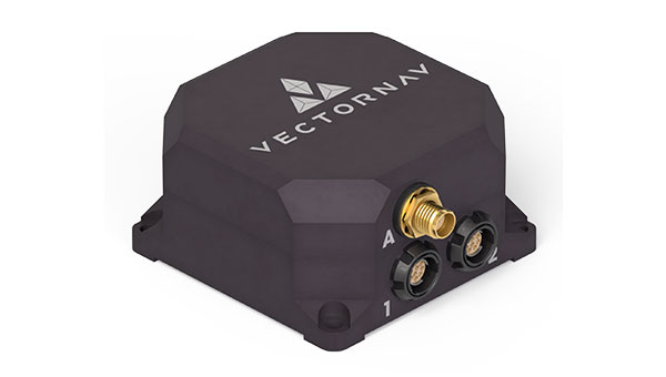
The VN-210-S GNSS/INS combines a tactical-grade inertial measurement unit (IMU) comprised of a 3-axis gyroscope, accelerometer, and magnetometer with a triple-frequency GNSS receiver. The integrated 448-channel GNSS receiver from Septentrio adds several capabilities, including L5 frequencies, moving baseline real-time kinematics with centimeter-level accuracy, support for Galileo OSNMA, and robust interference mitigation.
These capabilities and high-quality hardware offer improved positioning performance in radio frequency-congested and GNSS-denied environments.
The VN-310-S dual GNSS/INS leverages VectorNav’s tactical-grade IMU and integrates two 448-channel GNSS receivers to enable GNSS-compassing for accurate heading estimations in stationary and low-dynamic operations. The VN-310-S also gains support for OSNMA and robust interference mitigation, offering reliable position data across a variety of applications and environments.
The VN-210-S and VN-310-S are packaged in a precision-milled, anodized aluminum enclosure designed to MIL standards and are IP68-rated. For ultra-low SWaP applications, VectorNav has introduced L5 capabilities to the VN-210E (embedded) when using an externally integrated L5-band GNSS receiver. VectorNav, vectornav.com
Real-time INS Used in large fleets
The Atlas inertial navigation system (INS) is designed for autonomous vehicles, mapping, and other applications. Atlas provides users with ground-truth level accuracy in real-time, which can streamline engineering workflows, significantly reduce project costs, and improve operational efficiency.
Atlas is designed to be used in large fleets. It integrates a highly accurate, low-cost GNSS receiver and IMU with the Polaris RTK corrections network and sensor fusion algorithms. The company aims to make it easier for businesses to equip their entire autonomous fleets with high-accuracy INS.
The system features a user-friendly interface, on-device data storage, and both ethernet and Wi-Fi connectivity. Field engineers can easily configure and operate Atlas using smartphones, tablets, and in-car displays.
Atlas can be used in a variety of sectors, including autonomous vehicles, robotics, mapping, and photogrammetry. Its real-time capabilities and affordability can enhance the widespread deployment of ground truth-level location in fleet operations. Point One Navigation, pointonenav.com
UAV
USV For autonomous bathymetric surveys
The Apache 3 Pro is an advanced compact hydrographic unmanned surface vehicle (USV) designed for autonomous bathymetric surveys in shallow waters. With its lightweight carbon fiber hull, IP67 rating, and semi-recessed motor, the Apache 3 Pro offers exceptional durability and maneuverability.
The Apache 3 Pro uses CHCNAV’s proprietary GNSS RTK + inertial navigation sensor to provide consistent, high-precision positioning and heading data even when navigating under bridges or in areas with obstructed satellite signals. The built-in CHCNAV D270 echosounder enables reliable depth measurement from 0.2 m to 40 m.
The USV is equipped with a millimeter-wave radar system that detects obstacles within a 110° field of view. When an obstacle is encountered, the USV autonomously charts a new course to safely navigate around it. The vessel uses both 4G and 2.4GHz networks to facilitate effective data transfer.
Even with a fully integrated payload, the USV can be easily deployed and controlled by a single operator in a variety of environmental conditions.
The Apache 3 Pro ensures reliable communications through its integrated SIM and network bridge with automatic switching. It also features seamless cloud-based remote monitoring that offers real-time status updates to enhance control and security. Its semi-recessed brushless internal rotor motors minimize drafts, which can improve the USV’s maneuverability in varying water depths. CHC Navigation, chcnav.com
Anti-jamming receiver Provides stable navigation in three frequency bands
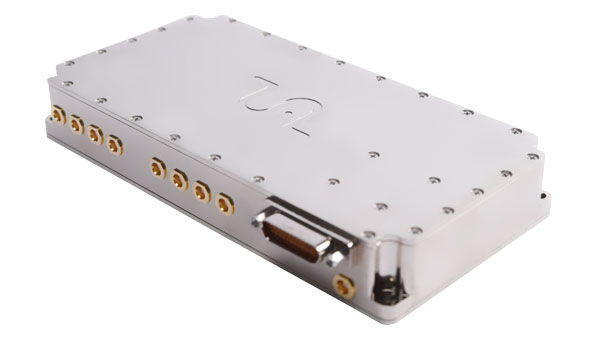
KV-AJ3-A provides a stable navigation signal in three frequency bands, including S-band, even in the presence of jamming and other harsh conditions. The technology is MIL-STD compliant and meets the EMI/EMC requirements for avionics.
The direction of interfering signals is determined using a phased array antenna, which can then remove jamming signals from up to three directions. The original signal is either restored and delivered to external GNSS receivers or processed by the internal receiver to obtain position data.
The key components of this anti-jamming device are based on custom ASICs that allow users to achieve high jamming suppression and SWaP. KV-AJ3-A can be used for fixed installations and land, sea, and air platforms, including UAVs.
Kosminis Vytis, kosminis-vytis.lt
Development kit With anti-jamming and anti-spoofing capabilities
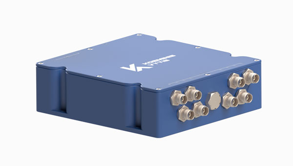
This eight-channel, CRPA, anti-jamming development kit is a set of instruments designed to help users add anti-jamming and anti-spoofing capabilities to their receivers.
The main development tool is NT1069x8_FMC — an eight-channel receiver board. The eight coherent channels are based on NT1069, the RF application-specific integrated circuit (ASIC) that supports a high dynamic range of input signals.
Each channel performs amplification, down-conversion of GNSS signal to intermediate frequency (IF) and subsequent filtering and digitization by 14-bit ADC at 100 MSPS.
The board is compatible with GPS, GLONASS, Galileo, BeiDou, NavIC, and QZSS signals in the L1, L2, L3, L5 and S bands. Each RF channel has an individual RF input with the option to feed power to an active antenna.
The board also has an embedded GNSS receiver and an up-converter, or modulator, which can provide connection to an external GNSS receiver.
Kosminis Vytis, kosminis-vytis.lt
Furuno Electric Co. has released its dual-band GNSS receiver chip, eRideOPUS 9, which can achieve 50cm position accuracy without correction data.
The product is designed to provide absolute position information and can be used as a reference for lane identification, which is essential for services such as autonomous driving. It also serves as a reference for determining the final self-position through cameras, lidar and HD maps.
By using Furuno’s Extended Carrier Aiding technology, the product can achieve high-precision positioning, which eliminates the need for RTK reference stations, correction data usage and correction data reception components.
The eRideOPUS 9 supports all navigation satellite systems currently in operation, including GPS, GLONASS, Galileo, BeiDou, QZSS and NavIC. It can also receive L1 and L5 signals. The L5 band signals are transmitted at a chipping rate 10 times higher than L1 signals, which reduces the effects of multipath. The L5 signals also improve positioning accuracy in environments where radio waves are reflected or diffracted by structures, such as in urban areas.
A dual-band GNSS module incorporating eRideOPUS 9 is being jointly developed with Alps Alpine Co. and is scheduled for future release as the UMSZ6 series.
A roundup of recent products in the GNSS and inertial positioning industry from the July 2023 issue of GPS World magazine.
TIMING
PTP Firmware To synchronize accurate time from GNSS
The 7.09.00 firmware with a precise timing protocol (PTP) feature enables users to synchronize accurate time from GNSS with other devices and sensors on a shared network. The 7.09.00 firmware’s PTP feature brings stable timing to a user’s other sensor systems connected through a local network to best support positioning, navigation and timing (PNT) and automotive and autonomous applications. The firmware includes SPAN GNSS+INS technology improvements — including a secondary INS solution for built-in redundancy and reliability in challenging conditions. The enhancements are available on all OEM7 cards and enclosures, including all PwrPak7 and CPT7 enclosure variants. The 7.09.00 firmware also features improvements to the time to first fix, a secondary SPAN solution for a more accurate and reliable GNSS+INS output and more. The 7.09.00 firmware is not for precision agriculture applications and is not supported on NovAtel’s SMART antenna products. Hexagon | NovAtel, novatel.com
Timing Antenna A multi-GNSS and high-performance device
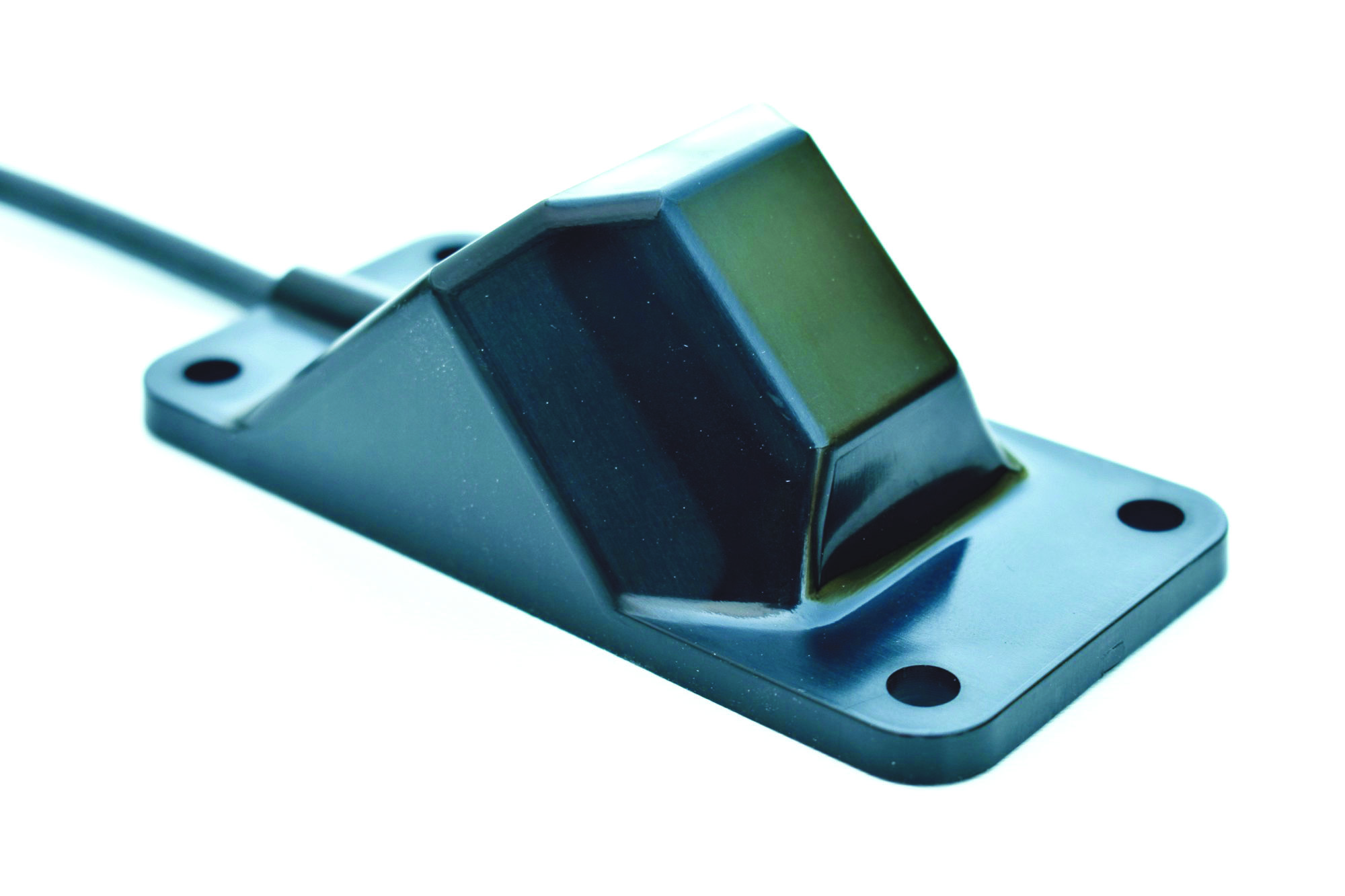
The AU-500 antenna is suitable for time synchronization applications. It supports all constellations in the L1 and L5 bands, including GPS, QZSS, GLONASS, Galileo, BeiDou, and NavIC. A built-in noise filter eliminates interference in the vicinity of 1.5 GHz caused by 4G/LTE mobile base stations as well as other radio waves that can adversely affect GNSS reception. The antenna is equipped with lightening protection and features a high-quality polymer radome that prevents snow accumulation. It is also waterproof and dustproof in compliance with IP67. The AU-500 achieves the best performance in time accuracy and robustness fundamental in critical infrastructure, when combined with Furuno’s GNSS receiver, GT-100. The antenna will be available this month. Furuno, furuno.com
Timing Module Dual-band and secure for 5G communications
The NEO-F10T offers nanosecond-level timing accuracy, meeting the stringent timing requirements for 5G communications. It is compliant with the u-blox NEO form factor (12.2 mm x 16 mm), allowing space-constrained designs to be realized without the need to compromise on size. The NEO-F10T is the successor to the NEO-M8T module, providing an easy upgrade path to dual-band timing technology. This allows NEO-M8T users to access nanosecond-level timing accuracy and enhanced security. Dual-band technology mitigates ionospheric errors and greatly reduces timing errors, without the need of an external GNSS correction service. Additionally, when within the operational area of a satellite-based augmentation system (SBAS), the NEO-F10T offers the possibility to improve the timing performance by using the ionospheric corrections provided by the SBAS system.
The NEO-F10T supports all four GNSS and L1/L5/E5a configurations, simplifying global deployments. It includes advanced security features such as secure boot, secure interfaces, configuration lock and T-RAIM to provide the highest-level timing integrity and ensure reliable, uninterrupted service. u-blox, u-blox.com
MOBILE
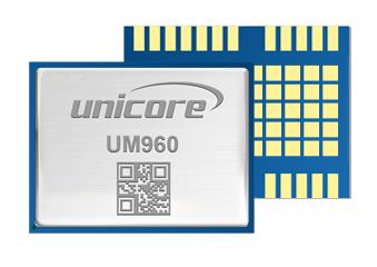
Image: Unicore Communications
GNSS RTK Module A high precision module for multiple applications
The UM960 module can be used for a wide range of applications, such as robotic mowers, deformation monitoring, UAVs, handheld GIS, and more. It features a high position fix rate and provides accurate and reliable GNSS positioning data. The UM960 module supports BDS B1I/B2I/B3I/B1c/B2a, GPS L1/L2/L5, Galileo E1/E5b/E5a, GLONASS G1/G2, and QZSS L1/L2/L5. The module also has 1,408 channels. In addition to its small size, the UM960 features low power consumption — less than 450 mW. The UM960 also supports single point positioning and real-time kinematic (RTK) positioning data output at 20 Hz. Unicore Communications, unicore.eu
CRPA System A GPS/GNSS anti-jamming system
This system eliminates interference by applying novel beam forming techniques. With an 8-array CRPA antenna, the system can assure the normal operation of a GNSS receiver in the presence of multiple jamming sources. The anti-jam GNSS CRPA system can be deployed using various configurations and operates with civil and military GPS receivers for land, sea, air platforms (including unmanned aerial systems), and fixed installations. The device has an embedded GNSS receiver that supports all satellite constellations. The device is lightweight and compact. It requires minimal integration training and easily integrates into new or legacy platforms. The antenna also offers assured positioning, navigation and timing. Tualcom, tualcom.com
IoT Antennas Rugged and designed to enhance connectivity
KP Performance Antennas’ internet of things (IoT) multiband combination antennas are designed to enhance connectivity for vehicle fleets and base stations. The IoT multiband combination antennas have dedicated ports for cellular, Wi-Fi and GPS bands. They are also indoor and outdoor IP69K rated and can withstand harsh environmental conditions, such as extreme temperatures, water and dust. The antennas are suitable for transportation emergency response and agriculture applications. The IoT multiband combination antennas are in-stock and available now.
KP Performance Antennas, kpperformance.com
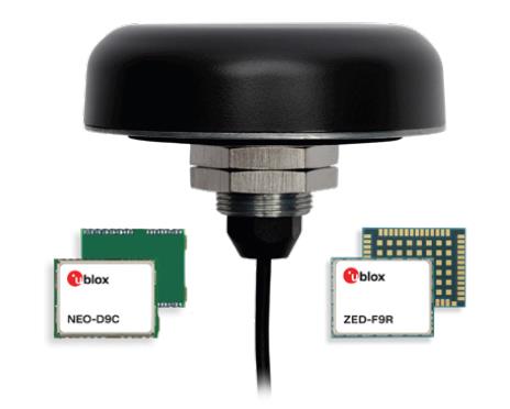
Smart Antennas With integrated technology for centimeter-accuracy
PointPerfect PPP-RTK augmented smart antennas combine the ZED-F9R high precision GNSS and the NEO-D9S L-band receivers from u-blox and Tallysman Accutenna technology. The multi-band (L1/L2 or L1/L5) architecture removes ionospheric errors, and the multi-stage enhanced XF filtering improves noise immunity while relying on the dual-feed Accutenna element to mitigate multi-path signal interference rejection. Some versions of the new smart antenna solutions include an inertial measurement unit (for dead reckoning) and an integrated L-band corrections receiver to ensure operation beyond terrestrial network reach. The PointPerfect GNSS augmentation service is now available in North America, Europe and parts of Asia Pacific. Tallysman Wireless, tallysman.com/u-blox, u-blox.com
SURVEYING & MAPPING
Airborne Laser Scanner Suitable for mapping applications
The compact and lightweight VQ-580 II-S meets the increasing requirements of compact laser scanners for medium- and wide-area mapping as well as for corridor mapping. The successor of the VQ-580 II airborne laser scanner, provides a maximum measurement range of 2.45 m. It can be integrated with gyro-stabilized mounts as well as into the VQX-1 Wing Pod. It features high accuracy ranging based on waveform-lidar technology. The VQ-580 II-S also has a mechanical and electrical interface for inertial measurement unit (IMU)/GNSS integration. RIEGL, rieglusa.com
Tablet and GNSS Solution For surveying applications
The RT5 rugged tablet data collector and the RTk5 GNSS solution, which integrate the form factor of the RT5 with real-time kinematic GNSS performance, are suitable for land surveyors, engineers, GIS professionals, and users in need of advanced GNSS positioning with an RTK rover. The RT5 is designed for surveying, stakeouts, construction layout and GIS mapping, and is bundled with Carlson SurvPC — the Windows-based data collection program. The RT5 can run SurvPC with Esri OEM for use in the field. The RTk5 adds an advanced GNSS solution to the RT5, enabling accuracy in a compact, light and versatile package. It comes with a custom-built pole and cradle, a survey-grade antenna, and a small portable helix antenna for handheld GNSS use. Carlson Software, carlsonsw.com
Lidar and RGB Solution Suitable for aerial surveying
The Zenmuse L1 integrates a Livox lidar module, a high-accuracy inertial measurement unit (IMU), and a camera with a 1 in CMOS on a 3-axis stabilized gimbal. When used with Matrice 300 real-time kinematic (RTK) and DJI Terra, the L1 forms a complete solution that gives users real-time 3D data, capturing the details of complex structures and delivering highly accurate reconstructed models. Users can render centimeter-accurate reconstructions with the high-accuracy IMU, a vision sensor for positioning accuracy, and the incorporation of GNSS data. The solution’s IP54 rating allows the L1 to be operated in rainy or foggy environments. The lidar module’s active scanning method enables users to fly at night. DJI Enterprise, enterprise.dji.com
Mapping Platform Real-time, crowd-sourced map data
CityStream Live is a real-time mapping (RTM) platform that enables the mobility industry — including connected vehicles, maps, mobility services, digital twins or smart city applications — to access a continuous stream of crowdsourced road data. This platform provides real-time data on nearly every road across the United States at a reduced cost. Utilizing a crowdsourcing network and artificial intelligence software, CityStream Live offers users and developers a live data feed to increase situational awareness, enhance driving capabilities, increase safety and more. By combining massive data aggregation with real-time data curation, CityStream Live is the first platform to deliver road data streams in real time and at scale, supporting several urban and highway use cases. Nexar, us.getnexar.com
Leica iCON gps 160 (Image: Leica Geosystems)
Smart Antenna Contains features that increase productivity on construction sites
The iCON gps 160 is a versatile solution for various applications. It can be used as a base station, as a rover or for machine guidance. The device is a modernization and enhancement of the successful Leica iCON gps 60, which has been well accepted in the market. The result is a smaller, more compact GNSS antenna with additional features and a larger display for ease of use. The Leica iCON gps 160 is particularly suited to complex construction environments with different GNSS requirements because the ability to switch between the different applications is at the users’ fingertips. Besides checking grade, cut and fill, stakeout points and lines, users can also benefit from using this solution for basic-level GNSS machine guidance. It has an integrated color display, a user-friendly interface, smart setup wizards and an intuitive construction-specific workflow to help contractors get the most out of their investment from day one. Size and weight reductions make the iCON gps 160 easy to handle, while the latest GNSS and communication technologies improve data reception. Leica Geosystems, leica-geosystems.com
UAV
Positioning Solution For UAV delivery applications
The PX-1 RTX is designed for accurate, robust positioning and heading for commercial UAV delivery applications. This solution enables UAV integration companies to add precise positioning capabilities so operators can plan and execute takeoff, navigation and landing tasks as UAV delivery advances to take on more challenging operations. The PX-1 RTX leverages CenterPoint RTX corrections and small, high-performance GNSS-inertial hardware to provide real-time, centimeter-level positioning and accurate inertial-derived true heading measurements. This solution allows operators precise control of UAVs during takeoff and landing to tackle more demanding operations in tight or partially obstructed spaces. It also minimizes operational risks from poor sensor performance or magnetic interference by ensuring greater positioning redundancy, which is especially important as commercial UAV delivery operations venture into difficult urban and suburban environments. Trimble Applanix, applanix.com
Certification Reference Guide A guide for the AAM industry
Business and government leaders, engineers, members of the media and any user with an interest in the future of flight can use the Honeywell State of UAS and UAM Certification Guide to help navigate and communicate the complexities of vehicle certification and operational approval across multiple vehicle segments. Industry professionals can access the living document online at aerospace.honeywell.com/us/en/products-and-services/industry/urban-air-mobility. The certification reference guide summarizes evolving Federal Aviation Administration and European Union Aviation Safety Agency rules across multiple advanced air mobility (AAM) segments. It also links to documents that AAM professionals can reference to better understand detailed certification requirements. Honeywell Aerospace, aerospace.honeywell.com
Image: A2Z Drone Delivery
Delivery UAV Suitable for aerial mapping, UAV inspection, forestry services, search and rescue operations, water sample collection, offshore deliveries, mining, and more
The RDSX Pelican leverages a hybrid vertical takeoff and landing (VTOL) airframe with no control surfaces to combine the reliability and flight stability of a multirotor platform, with the extended range of a fixed-wing craft. With no ailerons, elevator, or rudder, the Pelican’s durable design eliminates common points of failure and extends operational time between maintenance overhauls. Designed to meet the 55 lb takeoff weight limitation for Federal Aviation Administration Part 107 compliance, the Pelican can carry payloads of 5 kg on missions up to 40 km, roundtrip. The Pelican can be optimized for extended range operations or to deliver payloads from altitude with the company’s RDS2 UAV delivery winch. Available in multiple configurations, the RDSX Pelican can be customized for an array of missions. The Pelican enables deliveries from altitude where spinning propellers are kept far from people and property, mitigating consumer privacy concerns of low-flying UAVs while abating intrusive rotor noise. Alternatively, for missions in which the UAV can safely land at its destination, a simple servo-release mechanism can release payloads and expand the Pelican’s payload capacity.
A2Z Drone Delivery, a2zdronedelivery.com
UAS Suitable for mapping applications
The Trinity Pro UAS features Quantum-Skynode autopilot, using a Linux mission computer. This provides additional onboard computing power, increased internal storage, versatility and interoperability. Included in the Trinity Pro system is QBase 3D operations software. As the Trinity Pro is built on the Trinity F90+ UAS, its new capabilities include planning functions for missions requiring takeoff and landing at different locations, allowing for efficient and safe long corridor flights and beyond visual line of sight operations. The platform also incorporates advanced self-diagnostics to ensure safe operation. The UAS now includes an enhanced terrain- following system. Additionally, improvements to trigger point calculations results in improved image overlap and higher data quality. The Trinity Pro features automatic wind simulation for crash avoidance in bad weather and a linear approach for landing. The UAS is equipped with a downfacing lidar scanner that provides highly accurate ground avoidance and landing control. The system features USB-C ports for faster data transfer. The Trinity Pro is protected against dust and water damage and features increased wind limits of up to 14 m/s in cruise mode and 11 m/s during hover.
Quantum Systems, quantum-systems.com
Furuno will release a high-performance multi-GNSS timing antenna, the AU-500, in July. The antenna is suitable for time synchronization applications.
The AU-500 supports all constellations in the L1 and L5 bands, including GPS, QZSS, GLONASS, Galileo, BeiDou, and NavIC. A built-in noise filter eliminates interference in the vicinity of 1.5 GHz caused by 4G/LTE mobile base stations as well as other radio waves that can adversely affect GNSS reception.
The antenna is equipped with lightening protection and features a high-quality polymer radome that prevents snow accumulation. It is also waterproof and dustproof in compliance with IP67.
The AU-500 achieves the best performance in time accuracy and robustness fundamental in critical infrastructure, when combined with Furuno’s GNSS receiver, GT-100.
In addition to the AU-500, Furuno will also launch the AU-300, an L1 single-band antenna with the same level of performance as AU-500, except L5 signal reception.
A roundup of recent products in the GNSS and inertial positioning industry from the April 2023 issue of GPS World magazine.
TIMING
Image: Furuno
Global Timing Module Supports L1 and L5 GNSS signals
GT-100 is compatible with all GNSS constellations. The GT-100 realizes high robustness and standard of time accuracy and stability. The GT-100 features advanced multipath mitigation, anti-jamming and anti-spoofing as well as short-term holdover, ensuring superior performance even if L1 or L5 are jammed. The module delivers nanosecond precision for 5G wireless systems, radio communications systems, smart power grids and grand master clocks. Along with the GT-100, GT-9001 and GT-90 achieve a level of time stability of 4.5ns (1σ) and offer superior features and performance. Furuno, furuno.com
Image: UTStarcom
PTP Grandmaster Designed for mobile networks
The SyncRing XGM30E precision time protocol (PTP) grandmaster is designed for mobile networks and other applications requiring accurate time and frequency synchronization. It is an addition to the SyncRing line of network synchronization equipment. The SyncRing XGM30E is an indoor PTP grandmaster offering echo time accuracy of more than ±40 ns, which can meet the stringent timing requirements of demanding applications, including 4G and 5G networks. The clock complies with the PTP IEEE 1588-2008 standard, supporting major ITU-T frequency and phase and time profiles. SyncRing XGM30E supports synchronous Ethernet (SyncE) output on all service interfaces for accurate frequency synchronization, and SyncE input for enhanced time holdover operation during GNSS outages. The grandmaster includes an indoor rack-mount design and power supply redundancy with AC or DC built-in options and has flexible management options. The SyncRing XGM30E is available now.
UTStarcom, utstar.com
Image: Huber+Suhner
Copper-Free Data System For precise timing synchronization for high-performance networks
The GNSS and Power over Fiber GPSoF System receives, transmits and expands GNSS timing signals for the purpose of timing synchronization in data centers, central offices, distributed antenna systems or enterprise applications. It enables greater distances between the radio frequency source and the receiver system. It is also immune to RFI, EMI and EMP, contains remote control and monitoring via a web interface, and supports infrastructure installation due to direct GNSS signal evaluation.
Huber+Suhner, hubersuhner.com
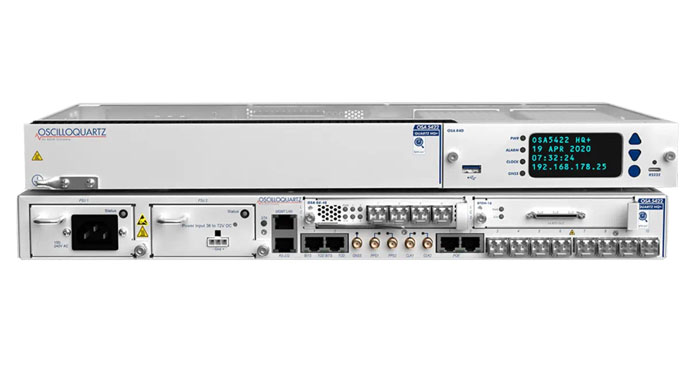
Image: ADVA
M-Code Device With advanced timing for military applications
The OSA 5422 grandmaster clock meets key requirements of military networks by providing advanced positioning, navigation and timing (PNT) capabilities and improved resilience. The OSA 5422 grandmaster clock is integrated with a highly reliable M-code receiver, which meets stringent frequency and phase synchronization needs. The device is equipped with multi-band, multi-constellation GNSS receivers for when M-code is not available. The OSA 5422 also has long holdover and precision time protocol backup, which enables it to maintain accurate timing even in the event of M-code disruption. The OSA 5422 supports legacy interfaces such as BITS and IRIG and features eight field-upgradable 10G bit/s ports and 1G bit/s interfaces. The device is suitable for most demanding military edge applications.
ADVA, adva.com; Brandywine Communications, brandywinecomm.com
AUTONOMOUS
Image: CHC Navigation
GNSS RTK Steering System Suitable for agriculture applications
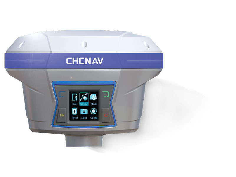
The NX510 SE Auto-Steer is an automated steering system that retrofits several types of new and old farm tractors and other vehicles. It can be connected to local real-time kinematic (RTK) networks or GNSS RTK base stations. NX510 SE is a guidance controller powered by multiple corrections sources and five satellite constellations: GPS, GLONASS, Galileo, BeiDou and QZSS. It has a built-in 4G and UHF modem that connects to all industry-standard differential GPS and RTK corrections to achieve centimeter-accuracy steering. NX510 SE contains GNSS and inertial navigation system terrain compensation technology, which maintains high accuracy in challenging environments and terrain. This makes NX510 SE suitable for ditching, planting and harvesting applications. In addition, AgNav multilingual software, operating on a 10.1 in industrial display, supports multiple guideline patterns that include AB line, A+ line, circle line, irregular curve and headland turn. CHC Navigation, chcnav.com
Image: Trimble
Module for Rail Monitoring For automated and semi-automated rail monitoring
The T4D Rail Module enables simple data collection and reduces office work required to automate movement detection for rail monitoring projects. The T4D software offers four main elements for automated monitoring: sensor management and data integration for GNSS; total station, geotechnical, vibration and environmental sensors; geodetic processing and adjustments for accurate results; analysis and visualization through several tools that provide real-time updates to support in-depth analysis and data presentation; and alarming and reporting. The T4D Rail module enables integration of rail as-builts collected with the Trimble GEDO system or with a track measuring bar paired with the Trimble Access Gauge Survey app. It also can automate calculations for track geometry parameters, generate analysis charts, and trigger alarms. The T4D software is offered in five editions to fit various project requirements. The editions include T4D Access, T4D Field, T4D Intermediate, T4D Geotechnical and T4D Advanced. T4D Access and T4D Advanced are the two editions that support the add-on Rail Module. Trimble Geospatial, geospatial.trimble.com
Image: Airobotics
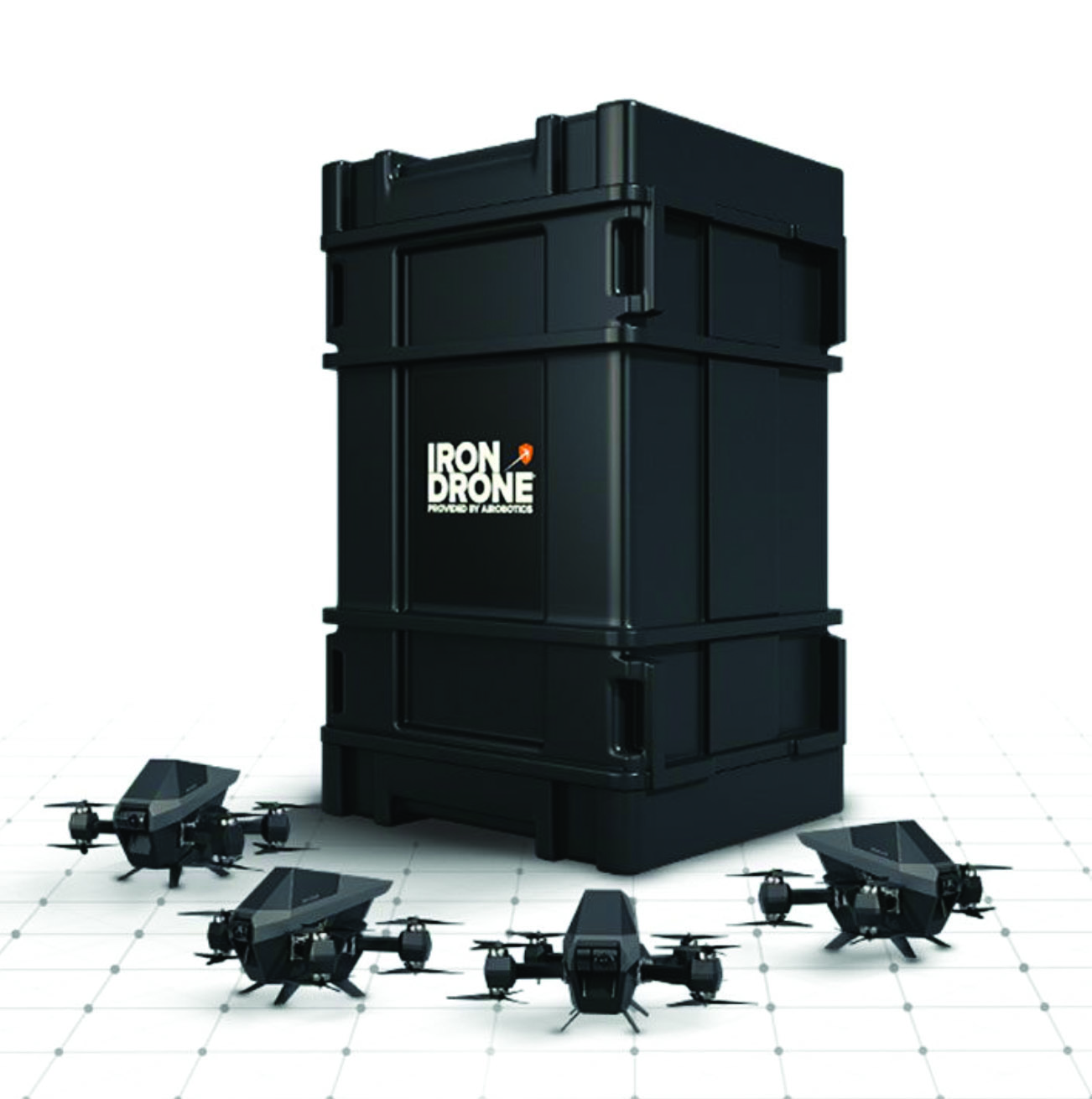
C-UAV Device Anti-UAV protection device
The Iron Drone system is an advanced counter-UAV device, designed to defend against hostile drones in complex environments with minimal damage. Iron Drone is an automated intercepting system designed to eliminate small drones without using GPS or radio frequency jamming. The Iron Drone system is launched from a designated pod and flies autonomously towards targets under radar guidance. It identifies the target using computer vision capabilities. The intercepting UAV follows the target then uses a net and a parachute to incapacitate it, capture it and lower it to the ground.
Airobotics, airoboticsdrones.com
Image: Rohde & Schwarz
Drone-based analyzer For UAV inspections
EVSD1000 VHF/UHF nav/drone analyzer provides highly accurate UAV inspection of terrestrial navigation and communications systems. The EVSD1000 VHF/UHF nav/drone analyzer is a signal-level and modulation analyzer for medium-sized UAVs. It features measurements of instrument landing systems, ground-based augmentation systems and VHF omnirange ground stations. The mechanical and electrical design is optimized for UAV-based, real-time measurements of terrestrial navigation systems with up to 100 measurement data sets per second. The analyzer provides high-precision signal analysis in the frequency range from 70 MHz to 410 MHz. This also includes the needed measurement repeatability to ensure that results from UAV measurements can be compared to flight and to ground inspections in line with ICAO standards. The EVSD1000 VHF/UHF nav/drone analyzer reduces runway blocking times, provides necessary measurement repeatability and offers measurement precision and GNSS time and location stamps. While streaming measurement data during a drone flight via the data link to a PC on the ground, the analyzer can also buffer data internally to ensure no results are lost if the data link is lost. Rohde & Schwarz, rohde-schwarz.com
SURVEYING & MAPPING
Image: SiLC
Coherent Vision Solution Suitable for advanced products
The Eyeonic Vision System is a frequency-modulated continuous wave lidar solution, which delivers high levels of vision perception to identify and avoid objects with low latency. At the core of the system is a fully integrated silicon photonics chip. It provides more definition and precision than legacy lidar solutions, with roughly 10 milli-degree of angular resolution coupled with millimeter-level precision. These features enable this solution to measure the shape and distance of objects with high-precision and at a large distance. The system combines the Eyeonic Vision Sensor and a digital processing solution based on a powerful field-programmable gate array. The flexible architecture enables synchronization of multiple vision sensors for unlimited points per second. The compact, powerful, vision solution is suitable for autonomous vehicles, smart cameras, robotics and other advanced products. It is available now. Pricing varies depending on configuration.
SiLC Technologies, silc.com
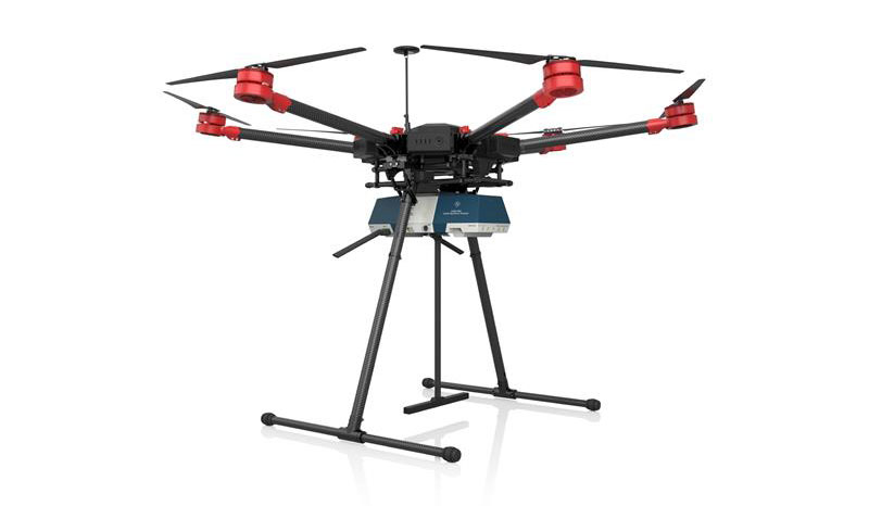
Image: SBG Systems
GNSS-Aided INS Easily integrated with lidar or other third-party sensors
Quanta Plus is a GNSS-aided inertial navigation system (INS). The device combines a MEMS inertial measurement unit (IMU) with a resilient GNSS receiver to get reliable position and attitude, as well as providing real-time kinematic (RTK) fixes. Quanta Plus includes motion profiles, which enable users to optimize the sensor parameters to suit different use cases. The built-in precise time protocol server ensures sub-microsecond synchronization with external devices such as lidar. The device also has a built-in datalogger, Ethernet interface for easy integration, and a web configuration interface for simple setup and control. The INS can be integrated with Qinertia, SBG System’s post-processing software. Qinertia improves the performance of acquired data during a mission using reliable RTK corrections from a wide range of continuously operating reference station networks, or by importing base-station data during the process. Quanta Plus also improves the accuracy of the position and attitude using forward and backward processing and by integrating a tight coupling between GNSS and IMU data. SBG Systems, sbg-systems.com
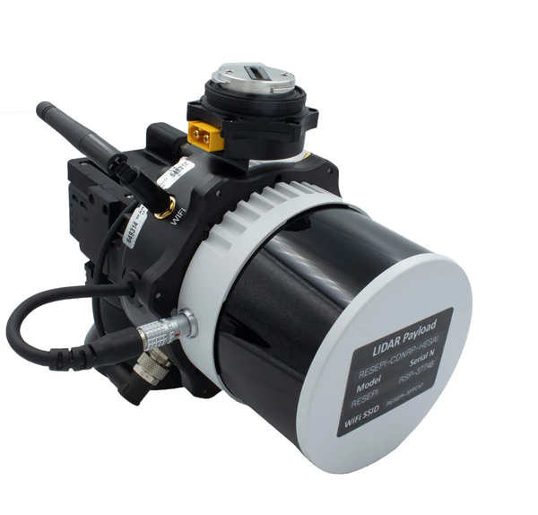
Image: Inertial Labs
Survey Laser Suitable for remote-sensing applications
The Resepi Hesai XT32 laser is designed for accurate remote-sensing applications. It can be used with commercially available lidar scanners, including Velodyne, Quanergy, Ouster, RIEGL, LIVOX and Hesai, as well as with UAVs. Resepi is completely modular, so users have full control for customization. The remote-sensing device uses a GPS-aided inertial navigation system with a NovAtel RTK/PPK single- or dual-antenna GNSS receiver, integrated with a Linux-based processing platform. It also comes with a 2 TB USB memory drive and has an embedded Wi-Fi cellular modem. Resepi has 3 cm to 5 cm point-cloud accuracy and can reach heights of more than 200 m above ground level. It is compatible with most UAV models; however, it is typically used with DJI M300, DJI M210 or DJI M600 models. The device is suitable for scanning and mapping, precision agriculture with lidar, simultaneous localization and mapping algorithm development, utility inspection and construction site monitoring. Resepi-supported software includes Hexagon NovAtel, PCPainter and PCMaster. Inertial Labs, inertiallabs.com
Image: CHC Navigation
IMU-RTK GNSS Receiver Provides robust and accurate positioning
The i90 GNSS receiver combines a GNSS real-time kinematic (RTK) engine, a high-end inertial measurement unit (IMU) sensor and advanced GNSS tracking capabilities to increase RTK availability and reliability. The embedded 624-channel GNSS receiver is compatible with GPS, GLONASS, Galileo and BeiDou signals. The i90 GNSS combines high-end connectivity modules: Bluetooth, Wi-Fi, NFC, 4G and a UHF radio modem. The internal UHF radio modem allows long-distance base-to-rover surveying up to 5 km. The built-in IMU ensures interference-free and automatic pole-tilt compensation in real time. An accuracy of 3 cm is achieved with pole-tilt range of up to 30°. The i90 GNSS receiver is suitable for construction and land surveying projects. CHC Navigation, chcnav.com
Image: CHCNAV
Field Application For Android devices
LandStar8 is designed to be flexible and user-friendly for surveying and mapping tasks. It is versatile, modular and customizable for topographic tasks such as surveying, stake out, cadastral, mapping and geographic information systems (GIS). Building on the legacy of LandStar7, the LandStar8 provides features such as a refined user interface, streamlined workflows, faster operation, and integrated cloud services. Cloud connectivity is built in for backup, data storage or remote technical support. LandStar8 has a simple and intuitive layout with large map windows and sharp graphics. Users can hide features they rarely use and display only those they need. They also can copy coordinate settings, control and staking points from another handheld controller by scanning a QR code. Projects can be edited and sorted by history and attributes. Custom coordinate systems, geoid models and coding libraries can be updated at any time by using resource packages. LandStar8 also features a terrain calibration wizard designed for non-expert users. CHCNAV, chcnav.com
Image: Position Partners
Survey Rover For accurate, survey-grade aerial mapping and photogrammetry
SmartSurveyor facilitates accurate, survey-grade aerial mapping and photogrammetry without the need for a connection between a camera shutter and a GNSS receiver. The fully compact, handheld aerial mapping survey rover is compatible with DJI Mavix 2 and 3 series and Phantom 4 Pro UAVs. The design is dissimilar from other UAV mapping systems in that it works from a UAV or smartphone and with two or more ground control points (GCPs) while using an ultra-matching technique. Once SmartSurveyor captures data, all photos and the GNSS file are uploaded to a PC and analyzed through the Agisoft UltraMatch workflow to confirm their accuracy before they are exported. Data can be managed in the cloud or on a local PC using software designed by MapSender. Additionally, this mapping tool works in tandem with the AllDayRTK subscription GNSS network service so that collected data can be uploaded to Tokara to remotely manage a project.
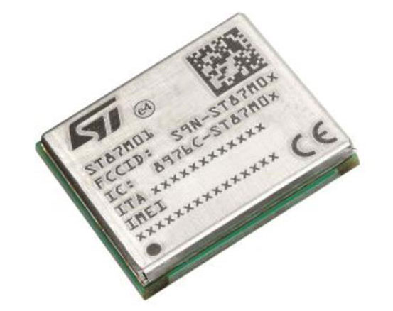
NB-IoT Industrial Module Complete with GNSS geo-location capabilities
Image: STMicroelectronics
The ST87M01 is a fully programmable, certified LTE Cat NB2 NB-IoT industrial module that covers worldwide cellular frequency bands and integrates advanced security features. The ST87M01 is an integrated native GNSS receiver with multi-constellation access, which ensures enhanced and accurate localization. The module has a diminutive 10.6 mm x 12.8 mm land grid array footprint, making it suitable for applications where a small form factor is key. The STM8701 offers flexibility for product developers, presenting a fully programmable internet of things (IoT) platform enabling users to embed their own code into the module for simple applications. A variety of protocol stacks are available to handle popular IoT use cases. It targets wide-ranging IoT applications that require ultra-reliable low-power wide-area network connectivity and has ultra-low power consumption with less than 2 µA in low-power mode and transmit output power up to +23 dBm. Suitable applications for the module include smart metering, smart grid, smart building, smart city and smart infrastructure applications, as well as industrial condition monitoring and factory automation, smart agriculture and environmental monitoring. The module also can be combined with a separate host microcontroller, permitting many more use cases. STMicroelectronics, st.com
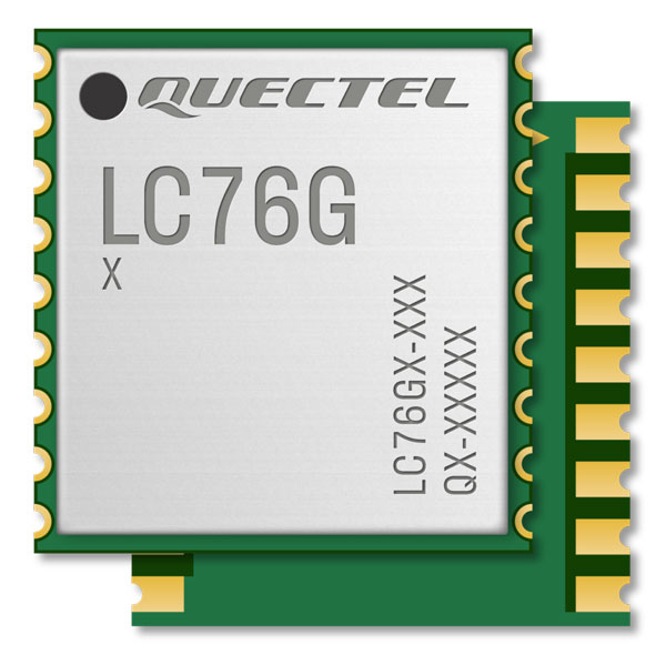
Image: Quectel
GNSS Module Designed for battery-operated, ultra-low power GNSS devices
The LC76G module is a compact, single-band, ultra-low power GNSS module that features fast and accurate location performance. The module can concurrently receive and process signals from the GPS, GLONASS, BeiDou, Galileo and QZSS constellations. The LC76G has an internal surface acoustic wave filter and integrated low-noise amplifier, which can be connected directly to a passive patch antenna and provides filtering against unwanted interference. With a compact size of 10.1 mm × 9.7 mm × 2.4 mm, the footprint of the LC76G is compatible with other industry solutions, as well as Quectel’s legacy L76 and L76-LB modules. The LC67G is designed for battery-operated, ultra-low power GNSS devices, such as wearable personal trackers, wildlife and livestock tracking, toll tags, portable container trackers, as well as several traditional markets such as shared mobility and low-cost asset trackers. Quectel Wireless Solutions, quectel.com
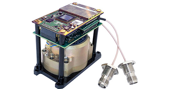
The INS-DH-OEM. (Photo: Inertial Labs)
Inertial Navigation System Incorporates NovAtel and Honeywell technology
The INS-DH-OEM utilizes a dual-antenna NovAtel GNSS receiver and a Honeywell HG4930-CA51 inertial measurement unit (IMU). The INS-DH-OEM contains Inertial Labs’ on-board sensor-fusion filter, navigation and guidance algorithms, and calibration software. The INS-DH-OEM has three axes, a full operational temperature range, advanced MEMS accelerometers and new-generation tactical-grade MEMS gyroscopes to provide accurate position, velocity, heading, pitch and roll. It is small and lightweight, measuring 85.5 mm x 67.5 mm x 52.0 mm and weighing 280 g. The dual-antenna NovAtel GNSS receiver is operational with GPS, GLONASS, Galileo, BeiDou and QZSS constellations. The INS-DH-OEM is compatible with most commercially available lidars including Velodyne, Riegl and Faro. The algorithms are suitable for different dynamic motions of vessels, ships, helicopters, UAVs, gimbals and land vehicles. Inertial Labs, inertiallabs.com
Image: MSO
Speed Sensor Multi-use sensor for workflow
The Speed Wedge MKII is a true-ground speed sensor and active motion detector for moving objects, based on radar doppler technology. This sensor is suitable for use in indoor and off-highway vehicles, conveyor belts, material flow and open channel water surface flow. The sensor contains a dead-reckoning system component for inertial measurement units and integrated management systems (IMS) in GPS/GNSS-denied environments such as in tunnels and underground mining operations. It also features sensor fusion with GNSS and IMS improving positioning accuracy, quality and reliability. Speed Wedge MKII deploys a radar front-end with planar antennas continuously emitting electro-magnetic waves at 24 GHz. It is designed for contactless measurement of speed and distance travelled independent on wheel/drive slip. For demanding applications Speed Wedge MKII is sealed and potted in a rugged encasing. Speed Wedge MKII is available in variants with pulse, serial RS232 and CAN-Bus output. High-speed up to 200 km/h is available.
MSO, mso-technik.de/home-en.html
Image: Orolia
GNSS Simulations Software For simulation and testing needs
Skydel GNSS simulation software can now generate more than 500 simulated satellite signals. This platform is suitable for GNSS users, experts and manufacturers, as well as users needing a low-Earth-orbit-capable simulation system. Skydel contains a feature that includes multi-constellation and multi-frequency signal generation, remote control from user-defined scripts, and integrated interference generation. In addition to generating a high channel and satellite count, Skydel also can produce navigation warfare signals without any additional hardware. Orolia, orolia.com
Image: Mikroe
Compact Add-On Board Provides access to L-band GNSS corrections
LBand RTK Click is a compact add-on featuring the NEO-D9S-00B, a professional-grade, satellite data receiver for L-band corrections from u-blox. Operating in a frequency range from 1,525 MHz to 1,559 MHz, the NEO-D9S-00B decodes the satellite transmission and outputs a correction stream. This enables a high-precision GNSS receiver to reach accuracies down to centimeter-level. An independent stream of correction data, delivered over L-band signals, ensures high availability of position output. LBand RTK Click also uses several mikroBUS pins. In addition, LBand RTK Click contains an SMA antenna for connecting a Mikroe-brand antenna. This antenna easily allows positioning in space, supporting GNSS L-band frequencies. LBand RTK Click implements advanced security features such as signature and anti-jamming mechanisms. It also can be integrated with other GNSS receivers from the u-blox F9 platform. Mikroe, mikroe.com
Furuno will participate in the Workshop on Synchronization and Timing Systems (WSTS) 2023, on March 13-16 in Vancouver, Canada.
The exhibition brings together the leading corporate and government experts to shed light on the diverse innovation taking place in the field of synchronization and timing.
Furuno’s Takahiko Ikeda, general manager of research and development, Systems Products Division, will speak on time synchronization in his presentation, “The Contribution on the Accuracy and Robustness of Time Synchronization in Multi-Constellation and Multi-Band GNSS Receivers.”
In this presentation, Ikeda will explain how L5 receivers are effective in time synchronization applications and how they contribute to the safe and secure operation of critical infrastructure, showing specific test results.
Furuno will also introduce and exhibit its latest GNSS receivers and antennas for timing. The featured products include:
• Timing multi-GNSS receiver module GT-100
• Multi-GNSS disciplined oscillator GF-8801/8802/8803 and GF-8804/8805
• Field time sync generator TB-1
• Dual-band GNSS antenna
Furuno Electric has announced a new global timing solution, GT-100, compatible with all GNSS constellations. The GT-100 realizes the world’s highest robustness and standard of time accuracy and stability. Interruption of GNSS satellite signals is a major concern for critical infrastructure systems. The GT-100 features advanced multipath mitigation, anti-jamming and anti-spoofing as well as short-term holdover, ensuring superior performance even if only L1 or only L5 are jammed.
The module delivers best-in-class nanosecond precision for 5G wireless systems, radio communications systems, smart power grids and grand master clocks.
Along with the GT-100, our GT-9001 and GT-90 achieve a level of time stability of 4.5ns (1σ) and offer superior features and performance.
UMSZ6 module allows high-accuracy vehicle positioning to within 50 cm without correction data
Photo: Alps Alpine
Alps Alpine and Furuno Electric Co. Ltd. have jointly developed the UMSZ6 series GNSS module, providing high-accuracy positioning to within 50 centimeters without having to use position correction data.
On typical 3-meter-wide roads, the module reliably enables vehicle positioning down to the lane level, a requirement of various V2X applications, and makes possible greater sophistication of autonomous driving functions. This is achieved using a multi-frequency GNSS receiver chip based on Furuno’s Extended Carrier Aiding technology.
The module is compact at 17.8 × 18.0 × 3.11 mm while conforming to automotive-grade specifications. Running costs associated with real-time-kinematic (RTK) base stations, correction data receiving, and correction data use are not needed, maximizing cost performance.
Under the joint agreement, Furuno developed and supplied an original multi-frequency GNSS receiver chip — eRideOPUS 9 (model ePV9000B) — and algorithm. Alps Alpine is the first company to use the chip, with the UMSZ6 series.
Alps Alpine plans to carry out evaluations within a real automotive environment to assess performance and interoperability with V2X and other communication modules. Mass production is expected in 2023.
Furuno Electric Co. Ltd., based in Nishinomiya, Japan, has developed the GT-88 timing module and GF-8801/02/03/04/05 disciplined oscillator for users who require UTC time-synchronized signals to meet the new 5G requirements.
They provide UTC time-synchronized timing signals (1 PPS/10 MHz) by receiving GNSS satellite signals. Achieved stability is better than that of an atomic clock, including a rubidium.
Photo: Furuno
The GT/GF-88 series includes a brand-new algorithm, named Dynamic Satellite Selection, that provides outstanding multipath mitigation, especially in urban canyon environments, the company said. The algorithm was developed by Nippon Telegraph and Telephone Corporation (NTT) based in Tokyo, Japan.
Extremely high stability of 4.5 ns (1 sigma) is obtained, only requiring reception of the L1 band (1575.42 MHz) frequency GNSS satellites. It was achieved by improving advanced position estimation algorithms and optimizing position calculation among several different GNSS satellite constellations. It allows users to achieve 5G-required performance without any changes to existing single-band GNSS antennas.
It incorporates the Dynamic Satellite Selection, an advanced multipath mitigation algorithm developed by NTT. Normally typical time synchronization performance deteriorates in urban canyon environments by the effect of multipath. The Dynamic Satellite Selection reduces this time error by one-fifth. This provides more flexibility when installing GNSS antennas. Consequently, the GT/GF-88 series now permits GNSS antennas to be mounted on walls, windows of tall buildings and other difficult reception environments.
The GT/GF-88 series continues to support GPS, GLONASS and QZSS satellite constellations, and now adds Galileo support. As the total number of satellites available increases, operational stability also increases.