Category: Machine Control / Agriculture

  • NovAtel SMART7 now default receiver on Fendt machines

    NovAtel SMART7 now default receiver on Fendt machines

    The Fendt 1000 Vario tractor. (Photo: Fendt)
    The Fendt 1000 Vario tractor. (Photo: Fendt)

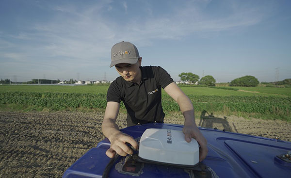
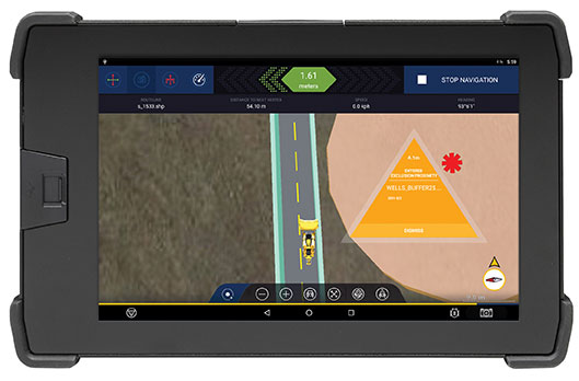
    Fendt machines in North America, Europe and the Middle East equipped with Fendt Guide guidance systems powered by Fuse Smart Farming now come with NovAtel’s SMART7 GNSS receiver as the default configuration choice.

    “We have been working with NovAtel for years, and their support and willingness to adapt to meet our needs makes them the key GNSS receiver supplier for our Fendt Guide guidance system,” said Bernhard Schmitz, director, FendtONE Market Readiness and Agronomy EME. “They are easy to work with and have high-quality products that integrate seamlessly into our machines.”

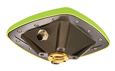
    The SMART7 combines a powerful GNSS receiver with a precision antenna in a durable, all-in-one enclosure designed to stand up to the vibration, weather and temperature demands of harsh agricultural environments. Delivering exceptional positioning, the SMART7 is optimized to succeed in demanding agriculture and off-road applications.

    Photo: NovAtel
    Photo: NovAtel

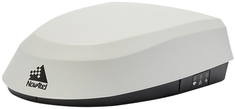
    The SMART7 uses multi L-band tracking to access TerraStar Correction Services globally, bringing repeatable centimeter-level accuracy to any application, anywhere in the world. Access to multi-frequency GPS, GLONASS, BeiDou, Galileo and QZSS signals provides better satellite availability in challenging environments.

    Resiliency to radio frequency interference is ingrained in NovAtel’s hardware designs, and the company’s Interference Toolkit firmware suite provides detection and additional protection from any potential intentional or unintentional interference.

    Powered by NovAtel GNSS+INS technology, the SMART7 uses an optional integrated inertial measurement unit (IMU) to provide continuous 3D positioning, velocity and roll/pitch/azimuth for deeper integration with vehicle guidance and steering systems. Additional optional features on the SMART7 include Wi-Fi and Ethernet for remote connectivity and monitoring.

  • Hemisphere GNSS announces Outback Guidance MaveriX for precision ag

    Hemisphere GNSS announces Outback Guidance MaveriX for precision ag

    Photo: Hemisphere GNSS
    Photo: Hemisphere GNSS

    Hemisphere GNSS has announced the Outback Guidance MaveriX for precision agriculture.  The solution is built around the new MaveriX agriculture application software platform to provide state-of-the-art guidance, steering and application control.

    The MaveriX application software includes a new user interface that provides an innovative tablet-like user experience with improved 3D graphics. The included adjustable widgets give users the freedom to customize their UI experience.

    “The announcement and the upcoming release of our new MaveriX solution is a key milestone for the Outback Guidance business and our loyal customer base,” said Jeff Farrar, general manager of Outback Guidance. “We are looking forward to building the Next Generation of Outback success for our customers on this new platform.”

    New M7 and M10 terminals (7 inch and 10 inch) are the centerpiece of the MaveriX. The M-series terminals deliver the latest display technology. They provide enhanced situational awareness for users and preferred features like auto-scaling and pinch-to-zoom capabilities.

    The MaveriX solution provides superior centimeter-level performance via the new eDriveM1 steering controller. The eDriveM1 offers AB Straight, AB Contour, Freeform Contour and Circle Pivot guidance modes and supports Shuttle Shift, Reverse Steer and the Outback Guidance eTurns feature for automated headland turns.

    The eDriveM1 can be paired with the proven ESi2 Electric Wheel, existing OEM Steer Ready, or hydraulic retrofit interfaces.

    Outback Guidance continues to offer machine specific installation kits for more than 1500 machine models. The A631 GNSS Smart Antenna delivers GNSS performance at scalable accuracy levels using real-time kinematic (RTK), SBAS and Hemisphere’s Atlas L-band service.

    The A631 supports RTK base functionality when paired with the Outback RTK radio option. The powerful MaveriX technology platform supports the AC110 Rate and Section control to maximize implement functions during planting, spraying and application tasks.

  • CHC Navigation introduces the NX510 Pro Auto Steer

    CHC Navigation introduces the NX510 Pro Auto Steer

    High accuracy and economical steering solution for most tractors in any field type

    Photo: CHCNAV
    Photo: CHCNAV

    CHC Navigation (CHCNAV) has released the NX510 Pro, a high-accuracy automated steering system designed for tillage, seeding, fertilization, pesticide application, and harvesting. With a steering controller and full GNSS RTK capability, the NX510 Pro can be quickly and easily mounted to various types of tractors and other farming vehicles to achieve ±2.5 cm pass-to-pass accuracy.

    “The NX510 PRO is the new generation’s auto-steering system, engineered to dramatically reduce installation time, simplify daily operations and increase the productivity of farms of all sizes,” said Yorke Tang, product manager of CHCNAV’s Precision Agriculture division. He said the NX510 Pro allows farmers to afford a high-performance yet affordable auto-steer kit to retrofit their tractors to optimize their work, reduce input costs and fuel consumption, and meet the main goals of sustainable agriculture:

    • Increase farm income
    • Promote environmental stewardship
    • Enhance the quality of life for farm families and communities
    • Increase production for human food needs
    Installation of the NX510 Pro auto-steering system to a tractor. (Photo: CHCNAV)
    Installation of the NX510 Pro auto-steering system to a tractor. (Photo: CHCNAV)

    Quick installation. NX510 PRO takes less than one hour from installation start to operator use. The entire system can be installed in 30 minutes and calibrated in about 15 minutes, significantly reducing downtime costs in the field.

    The intuitive AgNav software controls operations. It supports multiple guidance patterns to fit field layouts, including Straight AB line, A+ line, circle line, irregular curve and headland turn. It eliminates steering errors and overlapping passes on the field. The AgNav software also features real-time remote technical support from the local dealer’s help desk.

    Powered by local, network or satellite-based RTK corrections, the GNSS+INS terrain compensation technology ensures ±2.5 cm hands-free accuracy on any terrain. The advanced controller ensures full RTK accuracy in seconds, provides smooth auto-steering and ensures repeatable long-term accuracy.

    The CHCNAV NX510 Pro is now available worldwide.

  • Javad GNSS launches survey receiver based on Triumph-3 chip

    Javad GNSS launches survey receiver based on Triumph-3 chip

    Photo: Javad GNSS
    Photo: Javad GNSS

    Javad GNSS has launched a new field receiver based on the technology implemented in its Triumph-3 chip, which was introduced in May.

    The MCAnt-3S receiver hosts 874 GNSS signal channels, allowing it to track all current and future GNSS signals. It can be mounted on flat surfaces with four screws or mounted on standard poles.

    MCAnt-3S combines the receiver with a high-performance GNSS antenna in a compact and robust housing that is easy to mount, making it suitable for machine control applications. Communication is provided via CAN 2.0, USB 2.0 and RS-232/RS-422 interface.


    MCAnt-3S 874 All-In-View Channels

    • GPS C/A, L1C (P+D) including TMBOC (6,1,4/33), P1, P2, L2C (L+M), L5 (I+Q)
    • GLONASS C/A, P1, P2, L2C, L3 (I+Q)
    • Galileo E1 (B+C) including CBOC (6,1,1/11), E5A (I+Q), E5B (I+Q), Alt-BOC, E6 (B+C)
    • QZSS C/A, L1C ( P+D) including TMBOC (6,1,4/33), L2C (L+M), L5 (I+Q), L6 (L61/L62), L1S, L1Sb, L5S
    • BeiDou B1, B1C (P+D) including TMBOC (6,1,4/33), B2B (I+Q), B2, B2A (I+Q), AltBoc, B3
    • IRNSS L5
    • SBAS L1, L5 (P+D)

    Of the 874 channels in the Triumph-3 chip, 864 are general purpose GNSS channels and 10 are additional QZSS LEX channels. Each general-purpose channel consists of 10 correlators and a memory-code engine that allows reception of all existing GPS, GLONASS, Galileo, QZSS, WAAS, EGNOS and BeiDou signals with BOC and Alt-BOC capability. The memory-code engine is designed for existing truncated PN-code signals as well as future signals.

    Before reaching the GNSS channels, the navigation signal goes through a sophisticated RF data-processing module. This module performs digital filtering of input signals to divide the spectrum by several frequency bands (L1, L2, L5, etc).

    The module contains two special-purpose filters: an anti-jamming filter based on an adaptive LMS algorithm and a classic FIR filter to suppress static interference.

    The fast-acquisition module combines four independent modules, each of which can search very long navigation signals (up to 16,284 symbols) with a sensitivity of -150 dBm and run as the equivalent of 130,000 correlators.

  • Segway introduces autonomous lawnmower Navimow

    Segway introduces autonomous lawnmower Navimow

    Navimow model H3000E. (Photo: Segway)
    Navimow model H3000E. (Photo: Segway)

    Segway has launched a smart lawn mower, the Navimow. The autonomous mower uses GNSS to navigate and stay inside the programmed perimeter, set in an accompanying smartphone app.

    According to Segway, Navimow uses a GNSS-based “Extra Fusion Locating System” that help the mower achieve centimeter-level positioning accuracy while mapping out a working perimeter. Rather than using a perimeter wire to prevent the lower from leaving grid, Navimow combines multi-sensory data to create a virtual map while cutting grass in addition to using GNSS.

    The company has introduced four models, for lawns ranging from 500 square meters to 3,000 square meters. All cut lawns from 30-60 millimeters on a maximum slope of 45 degrees.

    During its runtime, the robot uses its smart navigation system and intricately plans the most effective cutting route. When necessary, it can make changes in direction to create a systematic pattern.

  • Hemisphere GNSS launches new Outback Guidance MaveriX

    Hemisphere GNSS has announced its new Outback Guidance MaveriX Precision AG Solution.

    The new MaveriX Precision AG solution, built around the new MaveriX agriculture application software platform, provides  guidance, steering and application control.

    The MaveriX application software includes a new user interface that provides a tablet-like user experience with 3D graphics. The included adjustable widgets give users the freedom to customize their UI experience.

    Included with MaveriX, the new M7 and M10 terminals with 7- and 10-inch form factors are the centerpiece of the solution. The M-series terminals deliver the latest display technology and provide an enhanced situational awareness for users and preferred features like auto-scaling and pinch-to-zoom capabilities.

    The MaveriX solution provides centimeter-level performance via the new eDriveM1 steering controller.

    The eDriveM1 offers AB Straight, AB Contour, Freeform Contour, and Circle Pivot guidance modes and supports Shuttle Shift, Reverse Steer, and the Outback Guidance eTurns feature for automated headland turns. The eDriveM1 can be paired with the ESi2 Electric Wheel, existing OEM Steer Ready, or hydraulic retrofit interfaces. Outback Guidance continues to offer machine specific installation kits for more than 1,500 machine models.

    The A631 GNSS Smart Antenna delivers unmatched GNSS performance at scalable accuracy levels using RTK, SBAS, and Hemisphere’s Atlas L-Band service. The A631 supports RTK Base functionality when paired with the Outback RTK radio option.

    The MaveriX technology platform supports the AC110 Rate and Section control to maximize your implement functions during planting, spraying and application tasks.

    Hemisphere GNSS designs and manufactures heading and positioning products, services, and technology for use in agriculture, construction & mining, marine, OEM, L-band correction service markets, and any application that requires high-precision heading and positioning.

  • Raven debuts driverless ag technology on Case IH Magnum

    Raven Industries, Inc., a manufacturer of driverless ag technology, showcased and demonstrated its OMNi suite of technology at the recent Farm Progress Show, one of the largest public farm shows in the United States. At the show, Raven featured its technology in the event’s Autonomy Zone, where the company debuted OMNiDRIVE on Case IH Magnum and showcased OMNiPOWER performing autonomous missions.

    Raven’s OMNiDRIVE is the first driverless ag technology for grain cart harvest operations. The company launched OMNiDRIVE in May 12, 2021, with a year one limited release of 75 aftermarket systems. Today, all systems have been committed to by founding dealers. Through the remainder of the summer, the company is holding OMNiDRIVE demonstration events at its Founders Club dealers, where participants get a first-hand view of OMNiDRIVE controlling a driverless tractor pulling a grain cart and commanding it to sync with a harvester.

    OMNiDRIVE is Raven’s aftermarket technology solution that transforms existing tractors into driverless machines. The technology connects, manages, and safely operates autonomous agricultural machinery and is compatible with:

    • Case IH Magnum CVT (2014-2020 models): M250 / 280 / 310 / 340 / 380 (available in October 2021)
    • New Holland CVT (2014-2020 models): T8.320 / 350 / 380 / 410 / 435 (available in October 2021)
    • John Deere 8Rs Powershift and IVT (2010-current models)

    OMNiPOWER is a self-propelled power platform that easily interchanges with farm implements, allowing the ag professional to perform multiple farming operations.

    Raven Industries makes precision agriculture, high-performance specialty films, and aerospace and defense solutions.

  • Topnet Live GNSS network expands to meet digitalization demands

    Topnet Live GNSS network expands to meet digitalization demands

    Topnet Live coverage map for 2021. (Image: Topcon)
    Topnet Live coverage map for 2021. (Image: Topcon)

    Topcon Positioning Group has expanded its Topnet Live GNSS network of correction solutions with more types of correction services and subscription options. According to Topcon, the growth is a result of the increasing demand for digitalization in various industries including construction, surveying, machine control and agriculture.

    Flexible service options include Realpoint, the real-time kinematic (RTK) service, and Starpoint, a Precise Point Positioning (PPP) service. The different services have varying delivery methods, coverage and reliable centimeter-level accuracy.

    Under a flexible subscription model, customers can purchase to suit their needs. An RTK service supported by precise point positioning (PPP), Skybridge, is available to maintain connectivity and productivity if the customer temporarily leaves RTK coverage.

    Topnet Live uses all four GNSS constellations — GPS, GLONASS, Galileo and BeiDou — to provide continuous accuracy and always-on service coverage. The service provides advantages for these industries:

    • Survey, Construction and Machine Control. Topnet Live removes the need for individual base stations, dramatically increasing flexibility, productivity and safety, and can drive large-scale projects with constant, reliable accuracy.
    • Precision Agriculture. The solution delivers fast, consistent, accurate positioning at any time day or night for soil preparation, seeding, spreading, spraying and harvesting.
    • OEMs, System Integrators, Product Designers. The solution provides scalable precise positioning and supports the implementation of flexible business models tailored to fit both OEMs’ and their customers’ needs.

    “The Topnet Live RTK network, first established over a decade ago, continues to grow, with 5,100 reference stations globally, a 14% increase in the last year,” said Ian Stilgoe, Topcon vice president. “We are growing throughout the world in areas where there is an increasing demand for productivity and accuracy through digitalization, with strong growth particularly in North America and Europe. We are focused on continued expansion to maximize support for our customers, so they always have the best options globally.”

    Original equipment manufacturers (OEMs) supplying automotive, industrial internet of things (IoT), autonomous robotics and all sectors that require positioning, navigation and guidance also benefit from the enhanced robustness of the network, Topcon said. OEMs can sell their hardware with correction services onboard and preconfigured for immediate use by customers, regardless of geographic location, with flexible subscription and licensing options to suit exact needs.

  • John Deere acquires Bear Flag Robotics to accelerate autonomous farm tech

    John Deere acquires Bear Flag Robotics to accelerate autonomous farm tech

    Photo: John Deere
    Photo: John Deere

    Deere & Company has signed a definitive agreement to acquire Bear Flag Robotics for $250 million USD. Founded in 2017, Bear Flag is a Silicon Valley-based startup that develops autonomous-driving technology compatible with existing machines.

    The deal accelerates the development and delivery of automation and autonomy on the farm and supports John Deere’s long-term strategy to create smarter machines with advanced technology to support individual customer needs.

    Deere first started working with Bear Flag in 2019 as part of the company’s Startup Collaborator program, an initiative focused on enhancing work with startup companies whose technology could add value for Deere customers. Since then, Bear Flag has successfully deployed its autonomous solution on a limited number of farms in the United States.

    The Bear Flag team consists of agriculture professionals, engineers and technologists focused on autonomy, sensor fusion, vision, data, software and hardware. They will remain in Silicon Valley where they will work closely with Deere to accelerate innovation and autonomy for customers across the world.

  • Topcon and DDK Positioning to provide GNSS hardware for maritime market

    Topcon and DDK Positioning to provide GNSS hardware for maritime market

    Photo: arild lilleboe/iStock/Getty Images Plus/Getty Images
    Photo: arild lilleboe/iStock/Getty Images Plus/Getty Images

    DDK Positioning will provide services and Topcon hardware to Oceaneering International

    Topcon Positioning Systems has entered into an original equipment manufacturer (OEM) contract with DDK Positioning Ltd. to supply GNSS hardware components.

    In July, Oceaneering announced an exclusive agreement with DDK Positioning to be the new provider of products and services to the offshore maritime market, delivered through the Iridium network and with Topcon OEM GNSS products.

    Image: Topcon
    Image: Topcon

    Topcon OEM GNSS components will be used by DDK Positioning to deliver its MAX services to Oceaneering International’s clients. These clients, primarily in the marine energy sector, can achieve accuracy to less than 5 centimeters with this new service.

    Founded in 2016, DDK Positioning has combined technical ingenuity with the Iridium satellite network to create a robust, resilient and completely independent GNSS-augmenting positioning solution.

    Oceaneering recently conducted an extensive review of how it delivers positioning services to its clients and evaluated the significant advances made in communications infrastructure and services over recent years.

    “Our extensive research of receivers in the market, and the performance of Topcon, made the decision for our route going forward,” said Kevin Gaffney, CEO of DDK Positioning. “Topcon’s experience, their extensive support network and leadership will allow us to effectively support multiple clients, in addition to Oceaneering. We see this as a long-term partnership. Both companies worked tirelessly to bring this together.”

    “With Topcon Positioning System’s extensive history in precise positioning, providing high performance and quality GNSS boards, antennas and receivers to the OEM industry for over 20 years, the company is well-positioned to supply DDK Positioning with the hardware needed to support their clients globally,” said Ian Stilgoe, vice president of Topcon emerging business. “Working closely with DDK Positioning and Iridium was key to meet the requirements of Oceaneering and the maritime market. Topcon is pleased to be part of this effort to bring the latest positioning technology to this market segment.”

  • Oceaneering and DDK Positioning enhance C-Nav positioning solutions’ offerings

    Oceaneering and DDK Positioning enhance C-Nav positioning solutions’ offerings

    Photo: arild lilleboe/iStock/Getty Images Plus/Getty Images
    Photo: arild lilleboe/iStock/Getty Images Plus/Getty Images

    Oceaneering International Inc. and DDK Positioning Limited have entered into an agreement for the provision of GNSS augmentation service and all associated software and hardware supporting Oceaneering’s C-Nav Positioning Solutions group offerings.

    Oceaneering provides engineered services and products primarily to the offshore energy industry. C-Nav uses precise point positioning corrections with worldwide accuracy of better than 5 cm horizontally and 15 cm vertically.

    DDK Positioning’s services are delivered through the Iridium satellite communications network coupled with hardware developed by partner Topcon. This pairing will enhance the ability of Oceaneering’s customers to precisely position their assets globally. The unified solution offers several benefits to Oceaneering’s positioning customers, such as two-way communication enabling machine control and feedback, and redundancy to cover potential signal losses.

    From launch, DDK Positioning will provide its MAX service to Oceaneering clients, which can achieve accuracy to less than 10 cm (2 sigma). The MAX service uses GPS, Galileo, and GLONASS constellations with further systems to be added within a year.

    “Significant advances have been made in communications infrastructure and satellite positioning technology over the last several years,” said Eric Smith, director of Survey Services at Oceaneering. “With this agreement, Oceaneering will be able to offer enhanced positioning technology allowing us to build on our strong industry track record while continuing to serve the positioning needs of our clients now and into the future.”

    “We are absolutely delighted to have signed an agreement with Oceaneering to provide our precise and reliable GNSS positioning solution to Oceaneering’s customers in the maritime energy industry,” said Kevin Gaffney, CEO at DDK Positioning. “This agreement demonstrates the need for an alternative GNSS augmentation service that increases the reach of services from pole to pole, with the added benefit of Iridium’s resilience and reliability.”

  • Trimble GuidEx enables control of machine navigation

    Trimble GuidEx enables control of machine navigation

    The Trimble GuidEx machine guidance system is an advanced navigation solution to guide machines along route corridors or to specific target areas.

    Photo: Trimble
    Photo: Trimble

    Trimble has introduced the Trimble GuidEx Machine Guidance System, an advanced machine navigation solution intended to quickly and efficiently guide machines along route corridors or to specific target areas, while providing local awareness using customer-provided mapping or engineering data to create exclusion and inclusion zones.

    Trimble GuidEx uses an integrated GNSS and inertial navigation system (INS) to compute a virtual reference point and precise heading, pitch and roll.

    Users can install the Trimble GuidEx system on anything from utility terrain vehicles (UTVs) to heavy equipment, on- or off-road.

    Trimble GuidEx provides streamlined design-stakeout navigation that eliminates the need for advance survey stakeout operations. This enables machine operators to navigate to an exact point without stakes or surveyors, such as for core-sampling operations.

    Corridor navigation allows users to efficiently complete a range of tasks including clearing paths for access routes and plowing snow. With comprehensive local machine data-logging, contractors can capture a range of data including position, time and speed.

    “Trimble GuidEx was built to meet the needs of natural resource exploration activities, but can be used for many other applications,” said Scott Crozier, vice president of Trimble Civil Construction. “This system improves productivity and awareness with easy, efficient, task-specific navigation.”

    To ensure work is done exactly where it should be, proximity and zone breach alarms can be set based on custom exclusion and inclusion zones.

    Regardless of the equipment or the application, Trimble GuidEx uses customer-provided data to keep operators aware of prohibited or dangerous areas and decrease time and money wasted on unnecessary work.

    Trimble GuidEx provides crossline navigation along predefined routes via an integrated software-based lightbar viewed on the display, including visual and audible alarms when operators breach user-defined distances from a centerline. The system also provides point and pad navigation information with intuitive navigational arrows, supported by a wide variety of data recording settings.

    Compatible with virtually any machine type, Trimble GuidEx connects equipment to the office to keep everyone aligned. Operators and supervisors can send mapping data to and from the machine and office to avoid rework.

    Reliable guidance data allows contractors to track machines by time or user-defined event triggers for a more accurate representation of the machine utilization cost of a project. Trimble GuidEx can leverage real-time kinematic (RTK) and CenterPoint RTX correction services for enhanced high-accuracy positioning.