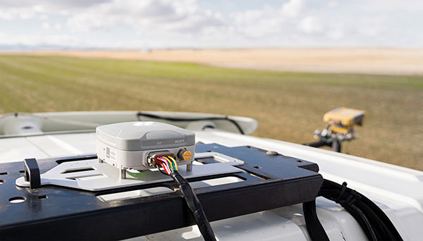
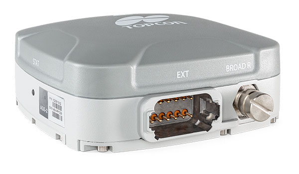
Topcon Agriculture is offering new manual guidance and autosteering receivers — the AGM-1 and AGS-2.
Topcon also launched Topnet Live, a real-time GNSS correction service. Under Topnet Live, the Realpoint service provides greater accuracy and a quick start-up time. Starpoint and Starpoint Pro provide service anywhere on the planet, independent of local networks. Skybridge allows subscribers to combine RTK and PPP correction services.
Accurate positioning is the cornerstone of site-specific management. It is not only required for accurate operations, but expansive data collection, enabling farm professionals to compare different types of information, such as yield, soil type and fertility, for better decision making.
The technology is used for machine operations and all associated tasks where tracking location data is relevant to crop optimization, including soil preparation, seeding, crop care and harvesting.
Photo: Topcon
Topnet Live. To support the range of agricultural applications, the receiver and steering controller uses the new Topnet Live correction services. Plus, with the option of Skybridge, users can maintain network connection during any RTK interruption.
“Topcon receivers are designed to suit virtually any agricultural machine type, make and model,” said Brian Sorbe, vice president of global product solutions. “Equipped with progressive reception and tracking capabilities, with the option of manual guidance or complete autosteering, the receivers are suitable for any size or type of operation. With access to the full range of correction services through the AGS-2, Topcon provides farmers with the right fit for their operation with accuracy on demand. Each unique farming operation may have differing accuracy requirements and this approach will benefit their operation.
“Calibrated to accuracies of within two centimeters, the new correction services provide reliable pass-to-pass precision,” Sorbe said. “Through a constantly improving network and variety of cost-effective subscription models, the service delivers reliable connection stability across the globe. With these new offerings, Topcon continues to offer powerful solutions to suit the variable demands of agriculture.”
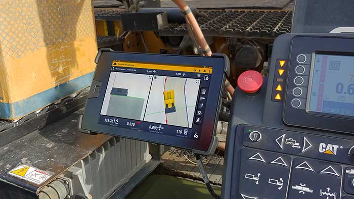
The T100 tablet is designed for use in the field. (Photo: Trimble)
Rugged tablet operates seamlessly with Trimble Site Positioning Systems and Trimble Siteworks Software
Trimble has announced the Trimble T100 Tablet, a high-performance tablet providing fast data processing for construction surveying applications. The rugged tablet brings fast computing and a large screen to the field, incorporating:
Directional keypad with programmable function keys
Large internal battery (92Wh)
Powerful Intel i5 processor for fast data collection, processing and quality assurance
USB-C fast-charging capabilities
Expandable dual EMPOWER module system, engineered to exceed the expectations of the outdoor field worker
User-configurable performance settings
IP-65 environmental specifications
Two bracket options for different display angles on the pole, enabling users to measure different locations more easily, with maximum flexibility for hard-to-measure locations
Optimized for Trimble Siteworks Software and supporting office applications such as Trimble Business Center, the T100 is suitable for both experienced and novice users. With accessories designed to specifically complement user workflows, the T100 avoids the burden of carrying multiple computing devices, while enabling users to complete quality assurance and quality control before leaving the field.
“The T100 tablet features the quality you expect from Trimble, with the flexibility to adapt to a variety of configurations and job site conditions,” said Scott Crozier, vice president of Trimble Civil Construction. “It is engineered to be ergonomic and portable on and off the pole, enabling users to stay mobile while they work, with features that increase productivity and reduce downtime.”
Earthworks Upgraded for Soil Compactors
Wider Range of Machine Types Now Available on the Trimble Earthworks Platform
Trimble Earthworks for soil compactors is a GNSS-based, 3D compaction control solution designed to make soil compaction more accurate, faster and easier. Operators will experience the same intuitive, easy-to-use Trimble Earthworks software interface currently available for excavators, dozers and motor graders for improved productivity.
Trimble Earthworks now includes soil compactors. (Photo: Trimble)
Compaction Control. Trimble Earthworks for soil compactors enables contractors to accurately control the compaction process, while reducing unnecessary passes that can result in over compaction. The platform makes the overall compaction process more efficient, with a higher level of accuracy and less rework. With soil compaction part of the extensible Trimble Earthworks platform, contractors can take advantage of shorter training times, less downtime and increased remote operator support in the field as well as benefiting from ongoing platform developments.
“Trimble Earthworks for soil compactors is easy to learn and more accessible for many different types of users because it leverages the intuitive Trimble machine-control interface and applies it to soil compactors,” said Scott Crozier, vice president of Trimble Civil Construction. “Adding this new machine type to the Trimble Earthworks platform gives contractors the ability to more easily manage their mixed fleets, train operators and manage jobsite data.”
Improvements in material/surface lifts and layer management allow for more accurate data and easier data management. Office-to-field connectivity enables efficient communication and data transferring across the project. In the field and office, contractors can easily interpret the valuable productivity data collected from the machine, such as work previously completed versus work completed that day.
Centimeter-level positioning and high-accuracy orientation of machinery enable automation of many construction, mining and farming tasks, and take them one step closer to being performed by autonomous machines. Machine control increases jobsite safety, operational efficiency and productivity.
Using data from GNSS satellites, total stations and 3D models, machine-control hardware and software solutions determine a machine’s current position on the Earth and compare it with the desired design surface, mining task or cultivation technique. They also monitor and sometimes control the position and orientation of implements — such as blades, buckets and seeders — with respect to the machine. By talking directly to the machine’s hydraulics, machine automation shifts responsibility for accuracy and speed from the operator to the technology.
On construction sites, automation guides motor graders, excavators, dozers and other heavy machines, making operations easier to manage. This makes contractors more productive and experienced operators more efficient. With this technology, less experienced operators are able to take on more complex tasks, and all operators become more accurate. Machine automation also increases the capabilities of the machines themselves, so that excavators and compact machines are now doing finish grade work once reserved for larger and more expensive dozers.
Operators in the cab and engineers and supervisors at their desks can control and monitor progress in real time, with views of the whole layout as well as specific slopes, roads, ditches and other elements, including those under water.
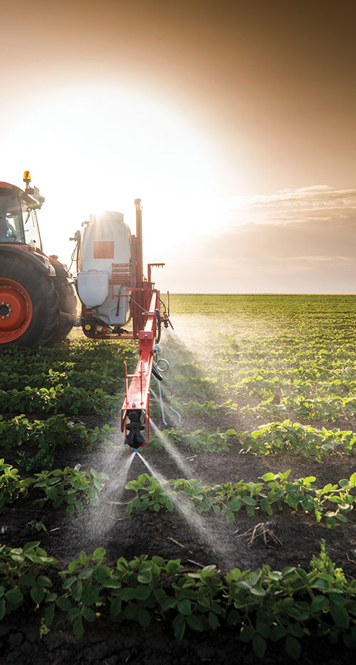
Using GNSS guidance to aid application of fertilizer, pesticides and herbicides saves time and money. (Photo: Septentrio)
About half of all motor graders and a third of all dozers use positioning sensors and a display to provide operators with the position of the blade with reference to the target grade. A typical machine control set-up consists of a GNSS receiver and a display (jointly referred to as a “cab kit”) and inertial measurement units (IMUs) on the blades and other implements.
From the display, the operator loads a project design, which tells the system the cut, fill and other design information it needs. The operator then chooses a lane and may choose a vertical offset, which temporarily adjusts the design grade, making it possible to accomplish the work in steps, from rough to finish grading. Operators can also record points and scan a pavement in real time as they repair it.
While used by the construction industry on earthworks equipment since the late 1990s, machine control has recently benefited from:
The increase in the number of GNSS signals available, particularly on the new L5 frequency
IMUs, which measure blade movements with respect to the machine 100 times per second, one order of magnitude more than non-IMU grade-control systems
The growing availability of continuously operating reference stations (CORS) and other GPS networks, which eliminate the need to set up a base
New mastless systems, which integrate a receiver into the top of the cab and connect it wirelessly with IMUs to orient the blade, obviating the need to install a long mast pole on the blade and connect it by cable to the receiver and improving safety, visibility and equipment durability
New interfaces designed to be as easy to use as a cell phone, shortening the operators’ learning curve.
While these developments are hastening the advent of autonomous construction, mining and farming machines, remaining barriers to this vision include hardware and software issues as well as questions of data exchange, legal liability and operator training — issues analogous to those facing the development of autonomous cars and trucks.
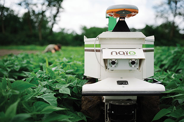
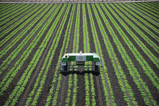
The DINO is a one-ton farming robot made by NAIO Technologies that operates autonomously using GNSS positioning and maps for navigation. Of the 170 NAIO farming robots currently in operation, about 30% are DINOs, which are typically used on large farms.
In 2016, NAIO and Septentrio, a manufacturer of industrial high-end GNSS technologies, began to research the integration of full GNSS solutions into NAIO’s robots.
Today, the DINO carries a Septentrio NR3, consisting of a GNSS receiver and antenna in a single housing, which provides it with RTK centimeter-level positioning accuracy. Farmers can use the NR3 to map their fields, then attach it to the DINO to guide it.
The DINO automates weeding within complex and quickly changing environments. NAIO plans to soon add seeding and fertilization to its robot’s capabilities.
To operate reliably in the narrow lanes between crops, the DINO requires an accurate GNSS receiver with strong resistance to multipath and jamming.
The safety of field hands and the protection of the crops also require the receiver to have good integrity, which is a measure of the trust that can be placed in the correctness of the information it supplies. Accuracy, robustness, and integrity are all strong suits of Septentrio’s NR3.
While the DINO mostly operates continuously, it sometimes stops to avoid animals or humans, or for other safety reasons. A major advantage of the NR3 and other sensors that NAIO is using, is that they enable the robot to perform cold-starts very rapidly and with a stable heading.
Machine control, guidance and automation defined
Using GNSS guidance to aid application of fertilizer, pesticides and herbicides saves time and money. (Photo: fotokostic/iStock/Getty Images Plus/Getty Images)
The terms machine control, machine guidance and machine automation are not interchangeable.
Machine control is a generic term that refers to the integration of positioning tools into a construction, mining or farming machine to determine its position on the Earth and relative to a desired design surface, mining task or cultivation technique.
Within machine control, machine guidancesystems display these data in the cab — assisting the machine’s operator in steering the machine and in maneuvering its implements to shape the ground, mine minerals, plant seeds or perform other related tasks — while machine automation systems directly steer the machine, achieving greater levels of precision than human operators could. The term automated machine guidance (AMG) is sometimes also used.
While farmers work on growing and gathering their crops in the most efficient ways possible, other people key to the agriculture industry are hunters. These hunters seek the most efficient and groundbreaking ways to carry out such tasks as plowing, planting, fertilizing, weeding and, finally, gathering.
This month, among other machine-control applications, we focus on using GNSS technology to improve agricultural efficiency. According to research firm MarketsandMarkets, the precision farming market is estimated to be $7 billion in 2020 and is projected to reach $12.8 billion by 2025, growing 12.7% every year between.
Factors driving growth include increasing farm mechanization in developing countries, rising labor costs, increasing strain on the global food supply, substantial cost savings associated with smart farming techniques, and government initiatives to adopt modern agricultural techniques. For a look at today’s technology, see our cover story.
James Litton
Sadly, this month we also say goodbye to a pioneer in the precision ag field. James D. Litton founded NavCom Technology in 1995 with three partners, Ron Hatch, KT Woo and Jalal Alisobhani.
Litton’s career began at Magnavox in the early days of GPS, where he worked on the original proposal for GPS Phase I and helped develop new and advanced commercial navigation and survey receivers for both the Navy’s TRANSIT system and the Air Force’s GPS.
In 1992, Litton opened a consulting firm, and in 1994, he and his partners founded NavCom with Litton as CEO. Under contract, NavCom developed a single-frequency WAAS-capable GPS aircraft navigation receiver.
“His work transformed agriculture into a data-driven, technological industry.” — Brad Parkinson
NavCom also began a relationship with Deere & Company, supporting more efficient and productive agriculture. This relationship was so successful that Deere, which recognized GNSS tech as a smart investment, purchased NavCom in 1999.
Litton continued to lead the company and serve as part of Deere’s senior management team for eight more years.
Among his many contributions to the GNSS field, his impact on global agriculture might well have been his greatest, according to Brad Parkinson, the original chief architect for GPS and Editorial Advisory Board member.
“His work transformed agriculture into a data-driven, technological industry that was incredibly more efficient,” Parkinson said. “The cost savings and increases in productivity have impacted billions around the world.”
Litton also authored several articles for GPS World.
Caterpillar’s Cat Command system enables operators, including disabled veterans, to control machines in dangerous environments from the safety of a remote command center. (Photo: Caterpillar)
Caterpillar, the world’s largest manufacturer of construction equipment, has invested in the development of autonomous vehicles for more than 30 years and has the world’s largest autonomous fleet of haul trucks.
Its Cat Command suite of remote and semi-autonomous products for the construction industry helps increase safety, machine utilization and productivity for hauling, loading, excavating, drilling and dozing operations. They include onboard electronic and vision systems that allow machines to be controlled without anyone in the cab.
Options include
The line-of-sight Cat Command Console, which is supported by a shoulder harness
The Cat Command Station, which can be located onsite, for line-of-sight operation, or offsite
The semi-autonomous Cat Command for Compaction technology, which automates soil compaction to help deliver consistent results.
Over time, the company expects most of its machines to become compatible with its Cat Command technology.
Here are a few examples of how construction companies are using Caterpillar technology:
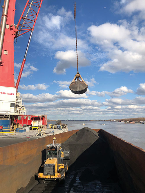
Cargo Barges. Associated Terminals, which transloads dry bulk and general cargo in the Port of South Louisiana, uses Cat Command to remotely control its small wheel loaders and excavators, keeping its personnel off the barges.
“It gives me a lot of peace of mind knowing that when we are doing our jobs, digging in these cargo holds in the vessels, my friend and co-worker is not operating the machine in the hold,” said Thomas Ramagos, a production manager for the company.
Fleet Management. Beverly Companies is a landscaping, snow removal and topsoil contractor in Chicago that owns equipment ranging from bulldozers to lawnmowers. The company uses my.cat.com and other Caterpillar fleet-management tools to track all its equipment in one place, help reduce machine downtime, manage repairs and maintenance, and order parts.
Civil Contracting. Saiia Construction Company, a civil contractor in Birmingham, Alabama, uses Cat Command to increase the safety of its employees, said Frank Montgomery, the company’s president. The material with which it deals is sometimes unpredictable, and rain events can change conditions significantly, explained Superintendent Clint Kennedy.
A remotely controlled front loader operates inside a barge. (Photo: Caterpillar)
Cat Command enables employees to work from an office trailer, rather than having to trudge through mud and muck to get to a piece of equipment. The controls in the seat are almost identical to the ones in the cab, Kennedy pointed out. Another employee can stand behind the chair and coach the operator.
High-quality cameras on site enable the operator to view the whole job site, while four on the machine enable the operator to distinguish brown dirt from red dirt and rocks from sand.
Caterpillar machines also collect massive amounts of data and transmit them over the air to the company, where they are analyzed and used in business applications.
Customers can access these data via my.cat.com and a mobile app to better understand and manage their vehicle fleets and operations, reduce fuel consumption, and improve productivity and safety. They can also access equipment locations, engine hours, parts and service records, and inspection reports.
According to Caterpillar, it had one million connected assets at the end of 2019, almost twice as many as three years earlier, and almost all its new construction machines are equipped with these connectivity systems. The Cat Productivity web-based suite of solutions works with Caterpillar machines of any age and brand. Of course, newer machines will provide richer data and more accurate results.
Trimble hardware and software tracked the position and motions of the machines and displayed to the operators the position of their tools underwater. (Photo: Trimble)
A new, twin cable-stayed bridge was built a few yards north of the original bridge by Tappan Zee Constructors LLC (TZC), a consortium of firms. The Left Coast Lifter — a huge crane on a barge previously used to replace a span of the San Francisco-Oakland Bay Bridge — was used to install groups of pre-assembled girders one full span at a time. Construction of the new bridge and demolition of the old one overlapped, with the entire project completed in May 2019.
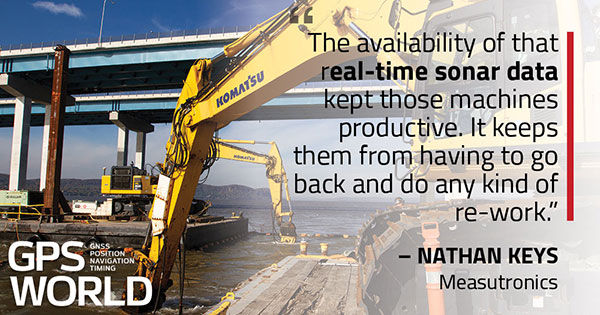
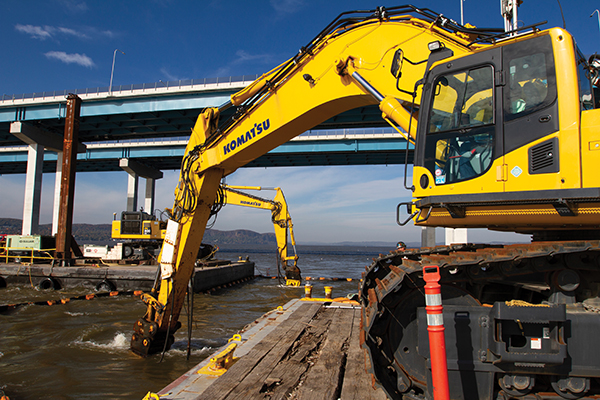
The project was huge, complex and on an accelerated schedule. “Challenges included the size of the bridge, the river’s current, tidal variations, the water’s turbidity and strong winds,” recalled Jonathan White, product manager for Trimble Civil Construction Field Solutions, Marine. Conditions were particularly challenging for bathymetric data collection before and during the project. “The low visibility in the water made it a prime situation for sonar technology to play a major role.”
A licensed surveyor conducted a pre-dredge bathymetric survey, which was loaded into the construction software as a baseline. Trimble hardware, software and technical advice supported the demolition of the old bridge.
“As they were beating down the bridge with the jack hammers and trying to pick up the rubble from the river with the cranes, the main challenge was to keep the 11 machines that they had updated in real time with the most accurate 3D data, so that they could keep working,” explained Nathan Keys, a geospatial engineer at Measutronics, a Trimble dealership and project lead for the Tappan Zee Bridge project.
Rather than mount a sonar to the front of each construction barge, they used a single survey vessel to serve the machines (eight excavators and three clamshell cranes) with real-time data, using networked connections to update one machine at a time.
Whenever a crane operator thought he was done in an area — the machine guidance display in his cab told him that he had achieved the design depth — the survey boat would verify that, and either give the operator the go-ahead to continue working or point out any spots that were still too high or too low. “That way, they would avoid having to return to an area, which costs time and money,” Keys said.
Trimble equipment provided the positioning of the machines, tracked their motions, and visualized them, enabling the operators to “see” underwater where their bucket, grapple tool, clamshell, or other tool was operating. Trimble supported its dealer and the consortium that was executing the project, White said. “Measutronics is very well versed in the capabilities of Trimble equipment and, more broadly, marine construction workflows generally. If a piece of their equipment went down, we could swap something out and provide them with any support that they needed, and expedite that support because we knew how crucial it was with them being in the field pretty much 24/7.”
Marine excavation. The survey vessel was equipped with a Teledyne RESON T-20 multibeam sonar and a Trimble Applanix POS MV WaveMaster for motion and position. “The eight excavators were equipped with a Trimble marine excavator guidance package, which includes a GPS receiver and angle sensors working together to give guidance to the tool, whether it is a jack hammer, a bucket or whatever,” said Keys. “They also had three clamshell cranes with rotational encoders on the wire-out drums, to keep track of the bucket’s vertical. The central piece to all this is the Trimble Marine Construction software, which takes in the data from all the sensors, including the sonar, in real time and updates the display in the cabin.”
To install its sensors on machines, Trimble provides flexible aftermarket kits that come with weld plates. “We just point out to the customer where to weld the plates, then we will put the sensors on, run the cables to the cab, and do all the wire runs,” Keys explains. “It does not matter whether it is a Caterpillar or a Kobelco or whatever. They are aftermarket systems, so they can go on pretty much any machine.”
This project, Keys clarified, involved only machine guidance, not automation. “We were not using any of the machines’ own sensors. We showed them where they were and then the operator would have to control it.”
Trimble provided precise position and heading, White said. “Through a very accurate measure of where each of these sensors is installed relative to the phase center of the GPS antenna, we can determine how the machine is moving and measure that movement, so that we know exactly where the tool is relative to the position that we are getting from our satellite trilateration. It is not like the guy is sitting in the seat drinking a cup of coffee while the machine parallel parks itself. However, he is receiving a lot of information from all those sensors as to his tool’s position relative to that GPS location.”
Keys said the machines constantly log the data and their movements while they are running. “We can go back into those log files and pull out whatever we want,” he said. “On the survey side, when they do a scan or a survey of an area, that data is captured as a 3D point cloud of what the bottom looks like, which you can import into any software to visualize and quantify the riverbed and the rubble.
“The availability of that real-time sonar data kept those machines productive,” Keys said. “It keeps them from having to go back and do any kind of re-work.”
White said the technology is getting more affordable and user-friendly. “That is leading us, as a manufacturer, to look for ways to help further bring it into our standardized workflows. We have been working with Teledyne on those objectives.”
Trimble is also keen to advance the networking component, specifically to the marine sector, White added. “It is relatively new to marine construction projects. The ability to have a sonar vessel speaking to a machine, and all the machines to speak to each other, and to share a survey file is a very important objective for us.”
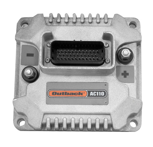
Hemisphere GNSS is primarily known for its Outback brand. It includes the Outback Guidance autosteering solution (a smart antenna that combines a GNSS receiver and a GNSS antenna in a single housing), the ESI² electric wheel that steers a tractor, the AC110 application controller that controls the rate and section, and the Rebel terminal in the cab that runs the application software. Hemisphere’s A222 smart antenna is being used by Raven and AgJunction.
“We put these product components together in different configurations for the solutions,” said Miles Ware, the company’s marketing director. “We support hundreds of tractor models with this type of solution or using our terminal for a steer-ready integration, in which you just plug our terminal and steering controller right into the tractor’s interface and it sends the commands to the hydraulic steering.”
One of the challenges with guidance for precision agriculture is that people think that tractors always operate in a wide-open field, where satellite availability is not a problem, Wares explained. That is often not true, however, due to obstructions such as tree canopies.
That is particularly an issue when using real-time kinematic (RTK) corrections for planting and seeding, which require a couple of centimeters of cross-track accuracy. Farmers want to quickly acquire a line and then maintain it. “All those functions are immediately impacted if you have challenges in the positioning solution,” Wares said.
The Outback Guidance brand offers three different packages:
Atlas Broad-Acre farming for uses that require sub-meter accuracy, such as large seeders or fertilizer sprayers;
Atlas H10 or the Atlas Row-Crop Service for row crop-level accuracy, for example to plant corn; and
a sub-inch package that uses RTK technology for automated steering.
One of the key benefits of automated steering is less fatigue for the driver, explained Roland Moelder, Hemisphere GNSS’ product manager for Agriculture Technology. “Especially when it is dark, it is very hard to do a proper job, minimizing the overlap but also not leaving gaps.”
Automated steering also enables farming practices that require more accurate driving than is humanly possible, such as for strip till, the practice of driving on exactly the same lines year after year.
Application-Guided Planting. Hemisphere’s devices can monitor, control and manipulate implements that use ISOBUS standard communications. Operators can select the attributes of their planter in the application; the display will then show them the planter’s location and which sections are active.
For example, if they are approaching a section of the field that they already planted, the AC110 control will turn off some of the seeding heads during the turn.
The same applies to spraying. The product automates the section control and coordinates it with the centimeter-accuracy steering.
Hemisphere’s solution is built around an after-market, so that farmers are not forced to buy the latest and greatest piece of equipment to take advantage of its technology, Wares added. “They can take a lot of their existing equipment, on which they may have already achieved the return on investment or are close to it, and add our solution.”
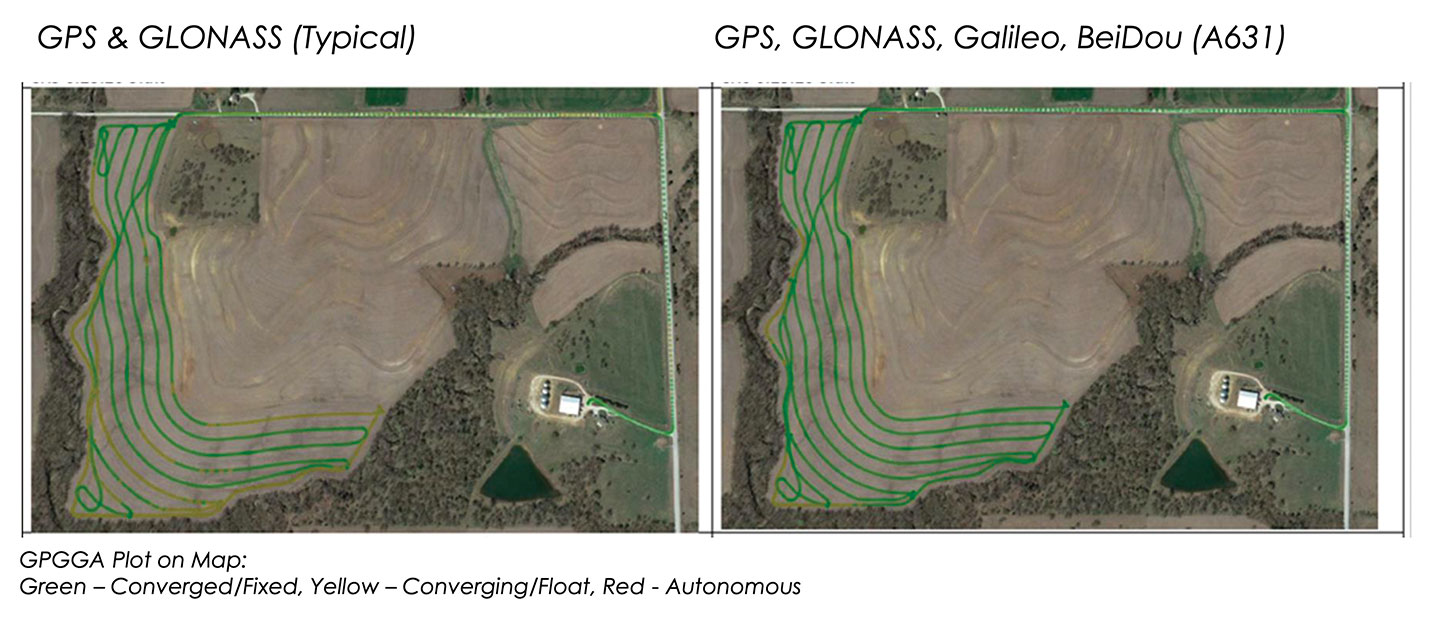
These two plots show how signals from additional GNSS constellations improve mapping. The map on the left is based on only GPS and GLONASS signals, which is typical. The one on the right is improved by adding signals from Galileo and BeiDou. In both images, the green lines are converged/fixed. In the image on the left, the yellow lines are converging/floating. (Images: Hemisphere GNSS)
Do-It-Yourself. To facilitate the installation of its smart antenna, Hemisphere works with all the manufacturers of tractors, sprayers, combines and other field vehicles to make kits that enable customers to perform the installation themselves.
“We take pride in that,” Moelder said, adding that some installations are done by dealers. The ESI2 electric wheel solution is a much easier installation than a hydraulic one. “We also support a list of ‘steer-ready’ vehicle installation kits, which are kits that utilize pre-existing components that are already on the OEM machine, where we just plug-and-play components and make it very easy for the customer to use what is already there.”
Historically, many of these solutions were built around adding hydraulic valves to a tractor, which was a lot of work. “Now, we can communicate directly to the smart valves on steer-ready models,” Wares said, “and it does not require, say, extra hoses, valves and brackets.” Electric wheels, which have tens of thousands of teeth, can manipulate the hydraulics with even finer resolution and are much easier to install than hydraulic valves.
Multi-GNSS technology has a big value for precision agriculture, Moelder said. He cited Hemisphere’s new S631 smart antenna, which tracks all available signals, greatly speeding convergence and maintaining it much better in challenging environments.
Unlike other corrections systems, Hemisphere’s Atlas uses all the available GNSS constellations. “If you are not taking advantage of them, you are really missing out,” said Wares. You cannot take full advantage of a multi-GNSS receiver without multi-GNSS corrections, he pointed out.
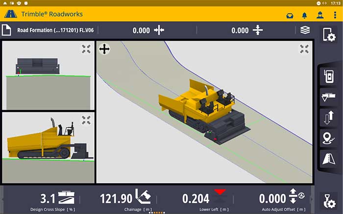
According to the company, Trimble Roadworks is an accurate, automatic 3D screen control system that can improve paving productivity and rideability by directly referencing the design rather than a surface or stringline to minimize asphalt usage, reduce waste and overruns, and finish projects on time and under budget.
The Android-based application runs on the 10-inch touch screen Trimble TD520 display. Operators can personalize the interface to match their workflows, and configurable views make it easier to see the right perspective for maximum productivity, the company said.
The software uses components from Trimble Earthworks, which Trimble says increases the portability of the hardware. Users also can download other third-party applications that provide the operator with additional useful tools inside the cab.
Screenshot: Trimble
“Trimble Roadworks is easy to learn and more accessible for many different types of contractors because it leverages the intuitive Trimble machine control interface and applies it to asphalt pavers,” said Kevin Garcia, general manager for Trimble Civil Construction Specialty Solutions. “This platform also makes it possible to include Trimble’s industry-leading paving technology as part of a connected site ecosystem of solutions, which is valuable for complex infrastructure projects.”
In addition, using a Trimble SNM941 Connected Site Gateway, Trimble Roadworks allows the transfer of 3D designs from the office to the machine via the cloud so that the operator is always using the latest design.
Trimble Roadworks 3D Paving Control Platform for Asphalt Pavers is now available globally through the worldwide SITECH distribution channel.
James D. Litton, GPS pioneer and founder of NavCom Technology Inc., died over the weekend at his home in California with his family at his side. He was 89 years old.
Litton was an early contributor to the development of GPS user equipment. He also played a pivotal role in the GPS-driven transformation of global agriculture that has greatly benefited humanity.
Litton was the director of engineering at Magnavox Research Labs when researchers were working on using CDMA for range measurements, a precursor to the GPS system. He also worked on the original proposal for GPS Phase I.
Later, as general manager of Magnavox’s Marine and Survey Systems Division, he helped develop new and advanced commercial navigation and survey receivers for both the Navy’s TRANSIT system and the Air Force’s GPS.
His team developed the first microprocessor-based commercial satellite navigation receivers and the first commercial GPS survey software. This led to Magnavox eventually having more than a 90 percent share of the survey receiver market.
The firm eventually held more than two dozen patents for improvements in GPS technology.
In 1992, Litton left Magnavox to start a consulting business. Two years later, with Ron Hatch, K.T. Woo and Jalal Alisobhani, he founded NavCom Technology Inc. With Litton as CEO, NavCom became a significant player in the GPS marketplace. Among its achievements was development — under contract — of a single-frequency WAAS-capable GPS aircraft navigation receiver.
NavCom also began a relationship with Deere & Company, supporting more efficient and productive agriculture. This relationship was so successful that Deere purchased NavCom in 1999. Litton continued to lead the company and serve as part of Deere’s senior management team for eight more years.
In recognition of his many achievements to the field, Jim Litton was presented the Institute of Navigation’s Hays Award in 2006.
Among his many contributions, his impact on global agriculture might well have been his greatest, according to Brad Parkinson, the original chief architect for GPS.
“His work transformed agriculture into a data-driven, technological industry that was incredibly more efficient,” Parkinson said. “The cost savings and increases in productivity have impacted billions around the world.”
Jim’s family has created a memorial fund at Doctors Without Borders for those wishing to make a donation in honor of his life and many good works. Click here.
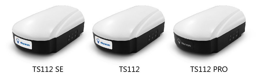
Harxon has introduced its TS112 family of smart antennas for demanding applications such as agricultural machine autosteering systems that require high positioning-accuracy. Harxon made the introduction in a virtual meeting on Jan. 13 from Shenzhen.
The TS112 family features Harxon’s latest GNSS positioning technology and offers scalable positioning solutions with increased GNSS availability, reliability and accuracy.
Each of the three models embed Harxon X-Survey four-in-one technology. The high-gain and wide beamwidth multi-constellation GNSS antenna integrates 4G, Bluetooth and Wi-Fi in one compact unit. They feature multi-point feeding technology, ensuring high phase-center stability and real-time kinematic (RTK) centimeter-level positioning accuracy.
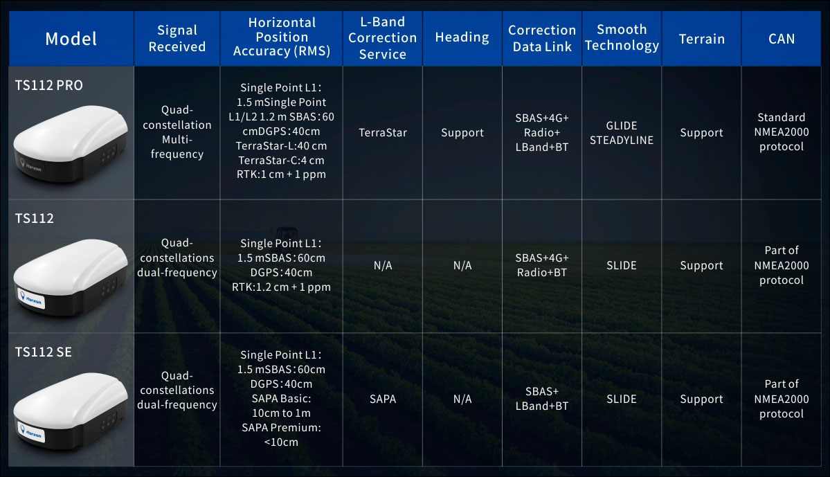
TS112 Smart Antenna Family Specifications. (Chart: Harxon)
The TS112SE, as the most affordable solution of the three, provides flexible positioning solutions via standalone positioning or dual-frequency precise point positioning (PPP) with accuracy from sub-meter to centimeter level while using Sapcorda’s SAPA (Safe and Precise Augmentation Service). Its comprehensive support and L-band augmentation service ensure solid satellite tracking without signal outage even in difficult terrains or problematic environmental conditions.
SAPA works as a reliable alternative economical positioning option with wide service coverage in the application environment that has poor LTE network coverage.
The TS112 integrates a high-precision GNSS module with multi-band GNSS receiver and Harxon’s four-in-one multifunctional GNSS antenna in a compact housing. It supports dual-frequency multi-constellations for consistent and robust satellite signal tracking and delivers RTK-level positioning accuracy for precision agriculture equipment and machine control. It offers a 4G and UHF radio modem for flexible correction transmission as well as wireless Bluetooth technology for easy connectivity in the field.
The TS112 PRO employs a future-ready Hexagon OEM GNSS module, offering precise positioning and advanced interference mitigation for space constrained applications and challenging environments.
With centimeter-level positioning utilizing TerraStar satellite-delivered correction services, Harxon’s TS112 PRO ensures globally available, high performance positioning without the need for network infrastructure. Harxon’s TS112 PRO also support NTRIP service, so in application environments where using a base station is not feasible, the NTRIP differential corrections could be transmitted to a rover using 4G networks and enable users reaching ultimate centimeter level positioning accuracy.
The TS112 PRO also features Hexagon’s Glide smooth positioning that offers superior pass-to-pass accuracy down to 20 centimeters for applications where relative positioning is critical.
All models in the TS112 family support Harxon Slide technology to provide smooth positioning and exceptional linear accuracy so that the guiding system can continue to guide during satellite signal outages or in challenging environments.
The newly released family also support Harxon terrain compensation algorithm that is capable of correcting deviations that caused by vehicle’s roll and pitch while working on uneven grounds or slopes. It helps users increase operational efficiency and saving cost in the field.
Adopting ruggedized and IP67 standard housing, the TS112 family equip NMEA0183 and NMEA2000 CAN ports, RS-232 serial ports for easy connectivity.
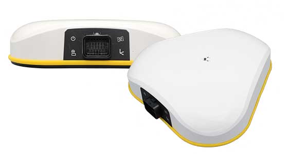
Trimble has introduced the Trimble AX940 and AX940i high-precision GNSS smart antennas, designed for a broad range of high-precision applications such as precision agriculture, milling machines in construction, forestry harvesting equipment, autonomous vehicles, port automation and mobile mapping.
With multi-frequency, multi-constellation support for GPS, Galileo, GLONASS, BeiDou, QZSS and NavIC, the smart antennas can deliver reliable centimeter-level accuracy in a variety of environments. In addition, the Trimble AX940 and AX940i provide reliable, high-accuracy positioning without the constraints of a local base station or cell modem by using Trimble RTX correction services.
Built-in inertial sensors on the AX940i allow a tight integration with GNSS observations in the RTK/RTX positioning and orientation engine, providing continuous high-rate low-latency output to guidance and control systems.
“The new AX family of smart antennas delivers the latest GNSS and inertial technology in an easy-to-integrate and rugged form factor,” said Thomas Utzmeier, general manager for Trimble OEM GNSS. “Reliable, robust and compact, the smart antennas are an ideal option for OEMs and system integrators to easily and quickly add high-accuracy positioning to their applications.”
The Trimble AX940 and AX940i provide flexible interfaces with high-speed data transfer and configuration; simplified integrations reduce development times; and an intuitive 3D graphical web page allows easy input of the lever arm for easier set up.
The full-featured smart antennas are equipped with 336 channels for multi-constellation support; Trimble RTX and OmniSTAR support; flexible RS232, USB, CAN and Ethernet interfaces; and advanced RF spectrum monitoring. The AX940i also includes Wi-Fi and Bluetooth connectivity for wireless interface and control.
Using the latest Trimble Maxwell 7 Technology, the AX940 and AX940i are designed with flexible signal management that enables the use of all available GNSS constellations and signals.
The Trimble AX940 and AX940i smart antennas are expected to be available in the first quarter of 2021 through Trimble’s OEM GNSS Sales Channel.
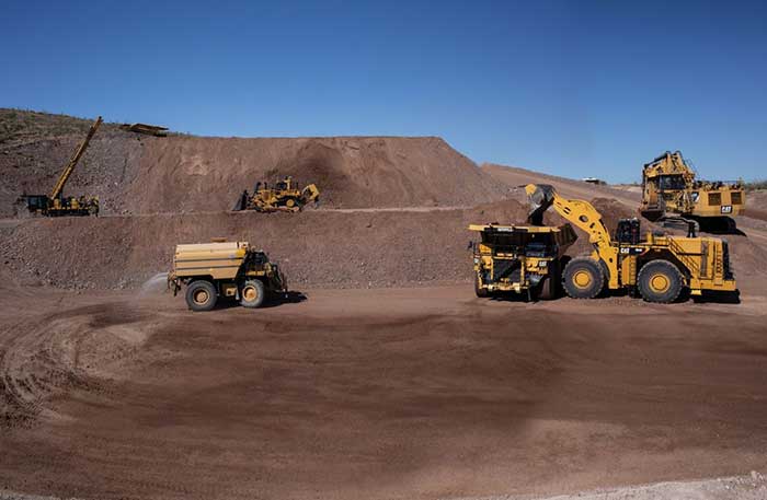
After years of testing and hype, not a lot of companies can say there are real applications for autonomous technology. However, at this year’s virtual CES 2021 trade show, both Caterpillar and John Deere, two companies known for their tractors and heavy equipment, showcased autonomous machines that are being used worldwide in farming and mining projects.
Photo: Caterpillar
Deerfield, Ill.-based Caterpillar, a first-time exhibitor at CES this year, said it has been involved in autonomy and use of GPS for more than two decades. “We were an early adopter of GPS when there were few satellites in the sky,” said Denise Johnson, company group president, resource industries. “We have 350 autonomous trucks operating 24-7 on three continents.”
The company’s autonomous vehicles, in addition to other technology, are being used around the clock in the Kearl Oil Sands project in Alberta, Canada.
“We are using autonomy primarily in mining operations in harsh environments. These [vehicles] are operating 24-7, with no loss time incidents,” said Bill Dears, Caterpillar worldwide sales and marketing manager. “We also track people underground with cameras and radar.”
In addition to production enhancement, safety is a factor in mining operations because of operator fatigue — something that is precluded by autonomous mining equipment, Dears said.
Agriculture uses variety of sensors, including GNSS
To Moline, Ill.-based John Deere, exhibiting at the trade show for the third time, agriculture is a high-tech industry that uses GPS, self-driving tractors, artificial intelligence and a multitude of sensors. The company rolled out its first self-driving tractors nearly 20 years ago, said Jahmy Hindman, John Deere CTO.
Photo: John Deere
The company won the CES Innovation Award for one of its tractor and combine product lines. “Both our planter and tractor have GPS and antennas to know where to drive and where exactly fertilizer [is to be placed],” Hindman said. “These tractors are self-propelled, with accuracy augmented with [real-time kinematic] sub-inch accuracy for the planters in a field.”
Among other requirements, Hindman said that tractors have to drive in a straight line, plant the required amount seeds and position them at the right depth. “When a tractor drives in a very straight line, the burden is off of the farmer. The yields increase—this is the way we see the progression of automation,” he said. “We are excited about 5G and its lower latency and high bandwidth. It opens up a lot of opportunity.”
Organizers roll out Indy Autonomous Challenge race car
At the virtual CES, representatives from the Indy Autonomous Challenge unveiled the Dallara IL-15 race car that will be used in a head-to-head race around the famous Indianapolis Motor Speedway on Oct. 23.
The Indy Autonomous Challenge, organized by Energy Systems Network and Indianapolis Motor Speedway, pits 500 university students, developing autonomous vehicle technology, against each other for a $1.5 million prize.
Logo: Indy Autonomous Challenge
Organizers say the speeds are estimated to be as much as 200 mph around the 2.5-mile track, for 20 laps, which enables researchers to evaluate how autonomous vehicle technology works in extreme conditions. They say that the goal of the race is to advance the implementation of autonomous vehicles and advanced driver-assistance systems (ADAS), much like the 2005 Defense Advanced Research Projects Agency (DARPA) Grand Challenge.
The race track has been the scene of much innovation throughout the years, said Doug Boles, Indianapolis Motor Speedway president. “Firestone tests tire technology there and that data transfers to our cars. One of the first conversations we had with Roger Penske [after Penske Entertainment bought the speedway] was about the autonomous challenge,” he said.
IAC sponsors include ADLINK, Ansys, Aptiv, AutonomouStuff, Bridgestone, CU-ICAR, Dallara, Indiana Economic Development Corp., Microsoft, New Eagle, PWR, RTI, Schaeffler and Valvoline.
Mobileye plans to test autonomous fleets in four cities
Intel subsidiary Mobileye plans to launch autonomous vehicle fleet testing in Detroit, Paris, Shanghai and Toyko. The announcement, made at CES by CEO Amnon Shashua, said that the company also plans to test in New York City, pending regulatory approval.
The company also plans to use in-house-built lidar sensors, while continuing to champion its camera-based testing. “We are using crowd-sourced data through the Cloud to build high-definition maps at scale,” Shashua said. “Thousands of product vehicles are sending us data.”
Shashua addressed a moderator’s question that cameras alone cannot be the technology of choice for autonomous vehicles. “The camera first is crucial from a technology and business point of view. We have to find out what is acceptable failure for Level 4 autonomy. Camera-only is ideal, but pushing the envelope for driver-assistance systems,” he said. “Consumer AV will take place in the 2025 timeframe. [Eventually], we can build lidar and radar to the same performance levels as camera systems. Lidar and radar can be added later for redundancy, but only for Level 4.”
Shashua said getting to Level 4 could take a decade, but that would be unsustainable unless there are government-funded projects to keep companies afloat. “By 2025, a subsystem will be good enough for consumers. Regulation is critical and sometimes it’s difficult to leap to a consumer level,” he said.
Not everyone believes what Mobileye is testing constitutes “driverless” status. To Alain Kornhauser Princeton University professor and transportation program director, who was head of the university’s team during the 2005 DARPA Challenge, not many companies are capable of full driverless capability.
“Unfortunately, I still see all of this as simply ‘eye candy’ to sell something that actually has no intention of delivering what it is implying. I still claim that the business case is zero, doesn’t exist, for personally-owned autonomous vehicles,” Kornhauser said in his Smart Driving Cars weekly newsletter. “Mobileye is nowhere close to being able to operate safely on most roads, let alone all roads. Thus, the consumer market has zero opportunity to scale.”
Kornhauser said that driverless testing is being conducted only in one place, Phoenix, by Waymo. “Neither Tesla nor Mobileye are driverless anywhere. They both require on-board human driver supervision,” he said. “That’s why they are only self-driving [tests].”
In other CES news:
GM CEO Mary Barra unveiled a single-seat electric vertical takeoff and landing (eVTOL) concept aircraft. The aircraft will be developed for future use as an air taxi. Barra briefly mentioned that the company’s Super Cruise self-driving technology will be integrated into 22 car models in a few years. The company also rolled out an electric vehicle for deliveries that can travel 250 miles on a charge and a motorized pallet for deliveries that can be tracked.
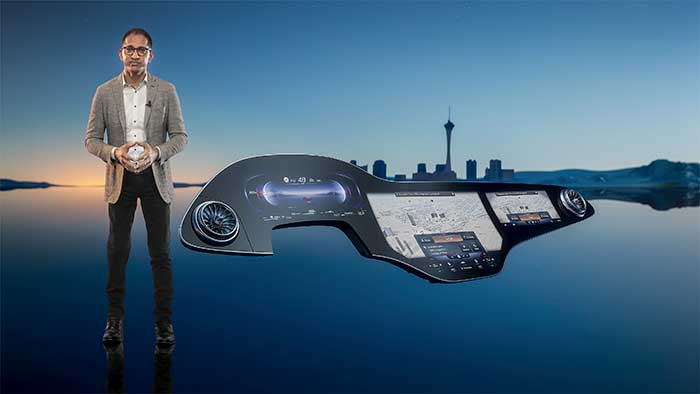
Photo: Mercedes-Benz
The Mercedes-Benz’ MBUX Hyperscreen, rolled out at CES, evaluates map data, surroundings and provides information about landmarks along a route, said Sajjad Khan, company CTO and member of the board of management. The new map feature, called Mercedes Travel Knowledge, allows a passenger or driver to ask a question as they drive by a landmark (“hey, Mercedes, what can you tell me about this building?”). The MBUX Hyperscreen is available in the new S-Class cars.
HERE Technologies introduced a mapping-as-a-service platform at CES. The platform is targeted to businesses wanting to create custom map datasets for advanced analytics and services, the company said. Some use cases include industrial yard mapping, leveraging probe data from private vehicle fleets in order to create or update a map.• A virtual CES is hard to get used to. After more than 20 years of covering the massive trade show in person, covering press conferences and conducting interviews online was sometimes a challenge. Sometimes the press conferences did not have question-and-answer sessions, or canned answers given to executives by public relations people. This doesn’t happen much during an in-person interview. In addition, trying to chat with “booth” personnel online was cumbersome and often those requests for information were ignored.