Aceinna was recognized as a partner-level supplier for 2019 and was inducted into the Supplier Hall of Fame in the John Deere Achieving Excellence Program.
Aceinna is a supplier of high-performance inertial sensor modules to John Deere’s operation in Fargo, North Dakota, for autonomous navigation and positioning.
Hall of Fame status is given after a supplier attains a Partner-level rating for five consecutive years. The Partner-level status is Deere & Company’s highest supplier rating.
According to John Deere, “Aceinna has earned this award in recognition of its dedication to providing products and service of outstanding quality as well as its commitment to continuous improvement.” Company employees accepted the recognition during formal ceremonies held on Jan. 29 in Davenport, Iowa.
Suppliers who participate in the Achieving Excellence program are evaluated annually in several key performance categories, including quality, cost management, delivery, technical support and wavelength, which is a measure of responsiveness.
John Deere Supply Management created the program in 1991 to provide a supplier evaluation and feedback process that promotes continuous improvement.
“We are honored to be recognized by John Deere for our fifth straight year for the technical merits of our IMU (inertial measurement unit) and our focus on product quality and on time delivery,” said John Newton, vice president for inertial products. “This John Deere award further adds to the industry recognition that Aceinna has earned over the last couple of years, positioning us as one of the industry leaders and innovators in the autonomous vehicles navigation and positioning space.”
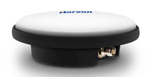
Harxon has launched a ruggedized GNSS antenna for applications subject to high shock and vibration environments such as i-construction machining applications. Integrated with reliable signal tracking and strong anti-interference performance, the IP69K ruggedized HX-CVX600A antenna provides end users with millimeter accuracy, durability and productivity, the company said.
I-construction promotes the use of automated machines on construction sites to improve productivity and provide support to workers.
The Harxon HX-CVX600A offers full support for reliable and consistent satellite signals tracking, including GPS, GLONASS, Galileo and Beidou, QZSS, IRNSS and SBAS, as well as L-band correction services.
By exhibiting a very stable phase center that adopts multipoint feeding technology, exceptional low elevation satellite tracking with symmetric radiation patterns, high gain with ultra-low signal loss, as well as outstanding wide-angle circular polarization (WACP), the Harxon HX-CVX600A performs with remarkable positioning accuracy and provides end users with full control of the job site, performing tasks more productively, meeting tighter positioning specifications, and avoiding rework caused by inaccurate positioning.
The HX-CVX600A GNSS antenna of Harxon also provides superior anti-interference performance. Its advanced low noise amplifier (LNA) excels in improved signal filtering and out-of-band rejection and restrains electromagnetic interference. It also provides strong multipath reduction capacity over all GNSS frequency bands for consistent and reliable GNSS signals, even under complicated environments such as congested urban areas or communication base stations.
The Harxon HX-CVX600A compact and low-profile antenna is Harxon’s first antenna with exceptionally firmness for hash operation environment as construction industry. The upper cover of the antenna is made of material with excellent chemical and high heat resistance. Its aerodynamic enclosure withstands exposure against dust, rain, splash or sunlight. Screws and pole mounts are both available, offering flexible installation.
The Harxon HX-CVX600A ruggedized antenna is now open for pre-sale; contact [email protected].
A roundup of recent products in the GNSS and inertial positioning industry from the April 2020 issue of GPS World magazine.
OEM
LPWA module
Collaborative IoT solution
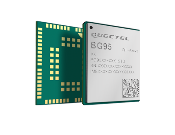
Photo: Quectel
Quectel Wireless Solutions’ LPWA module BG95 is being integrated with Microsoft’s Azure Device software development kit (SDK). The BG95 cellular module is based on the Qualcomm 9205 LTE modem. The integration will provide direct and secure connections to the Azure IoT Hub and provide full support for Azure device management. Customers can connect their BG95 devices to the Microsoft Azure cloud where they can build, manage and deploy internet of things (IoT) solutions at scale, significantly accelerating time to market. The BG95 module is a highly integrated variant supporting integrated GNSS, Cat M1, Cat NB2 and EGPRS (also called edge). The module complies with 3GPP Release 14 and delivers improved capabilities in power consumption, data rates and hardware-based security.
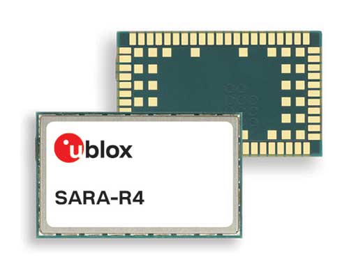
The SARA-R422 product series of LTE-M/NB-IoT and EGPRS cellular modules now include GNSS variants for internet of things (IoT) data, devices and ecosystems. The SARA-R422M8S module is pre-integrated with the u-blox M8 GNSS receiver and a separate GNSS antenna interface. This provides highly reliable, accurate positioning data simultaneously with LTE communications. The module also supports hybrid positioning strategies, in which positioning data provided by satellite constellations is enhanced with data from the u-blox CellLocate service, ensuring that location data is always available everywhere. The SARA-R4 series is designed for a wide range of mission-critical IoT solutions such as connected healthcare, industrial monitoring, point of sale and vending terminals, tracking and telematics devices, as well as smart lighting solutions and building automation.
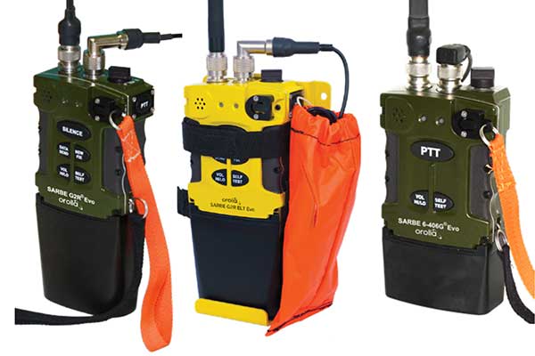
The new line of Sarbe search and rescue beacons. (Photo: Orolia)
Orolia has improved its Sarbe Evo search-and-rescue (SAR) beacon range line to deliver upgraded operational capabilities. The line offers new operational improvements to meet revised Cospas-Sarsat requirements in operating lifetime, location accuracy, voice signal management, integrated protocols, testability and maintenance. Also a focus of the upgrade was more robust and frequent GPS/GNSS position acquisition with the GPS, Galileo and GLONASS satellite constellations.
ADVA’s GNSS assurance solution could help companies dependent on satellite-based timing. (Photo: Business Wire)
ADVA’s GNSS assurance solution helps companies dependent on satellite-based timing. The centralized GNSS monitoring and assurance tool uses artificial intelligence and machine learning for comprehensive predictive maintenance. The customer-owned tool enables users to collect and analyze huge amounts of information from across the network to remotely identify issues and protect networks from GNSS vulnerabilities, including jamming and spoofing attacks. It also helps to identify GNSS obstruction issues, detect blind/poor spots that appear over time, and enable optimal antenna positioning. Built into ADVA’s Ensemble Controller network management suite with Sync Director, the solution enables customers to detect potential problems in advance and maintain the highest quality of network synchronization. It complements the limited distributed approach to GNSS assurance with a centralized global system, providing a boost to critical infrastructure now dependent on satellite-based timing.
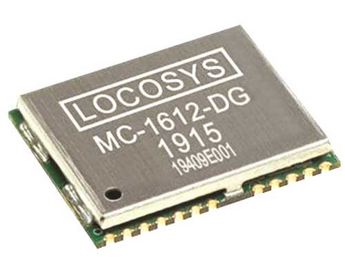
The Locosys MC-1612-DG is a single-band multi-system with an ARM-based processor that supports GPS, GLONASS, Galileo, QZSS and SBAS. The embedded micro-electro-mechanical systems (MEMS) sensor is equipped with dead-reckoning software and provides six-axis accelerometer and gyroscope data. The extended Kalman filter algorithm combines GNSS and MEMS sensor data with a weighting function that relies on GNSS signal quality. In adverse GNSS conditions such as urban canyons, tunnels or parking garages, the dead-reckoning features boost accuracy with the software filling the gaps. It supports three-dimensional dead-reckoning and standard NMEA output, and has Flash memory, TCXO, RTC crystal, LNA and SAW filter.
The automotive-grade solid-state RS-LiDAR-M1 family has the performance advantages of traditional mechanical lidar, while meeting requirements for mass-produced vehicles. The RS-LiDAR-M1Smart is embedded with an artificial intelligence perception algorithm that transforms conventional 3D lidar sensors into a full data analysis and comprehension system, outputting semantic-level structured environment information in real time for autonomous vehicle decision making. The RS-LiDAR-M1Smart outputs two redundant channels of data: the original point cloud and the object list. The redundacy provides vehicles with a range of sensing results — dynamic, static, inside and outside the road. Also available is the RS-LiDAR-M1Simple.
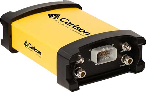
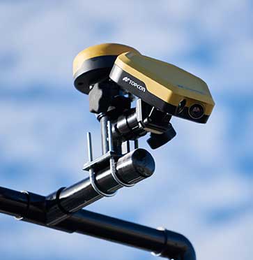
The Vsx7 multi-frequency position and heading receiver is designed specifically for machine control and can be mounted by bolts or with magnets on heavy equipment. Paired with the Carlson A45 antennas, the Vsx7 features high-precision positioning in Athena RTK, Atlas L-band and SBAS and heading accuracy of up to .01 degrees. The whole Vsx7 system is designed to operate in harsh conditions from –40° F to +158° F. The Vsx7 is primarily used in the mining and construction industries, but can be used in similar industries with companion software, Carlson Grade. Field data can be collected and viewed in real time both at the machine with either the MC8 or MC10 control box as well as in the office with Carlson Command.
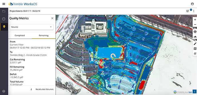
Trimble WorksOS is a new Software-as-a-Service (SaaS) operating system. The cloud-based system will integrate data from Trimble and third-party providers across the entire civil construction project lifecycle, including estimating, scheduling, designs and the field. Currently, site supervisors and project managers jump between multiple systems to keep track of daily production quantities, labor/equipment hours and equipment maintenance schedules. Works OS is designed to bring real-time visibility into jobsite progress, schedule and cost. Users will be able to log into a single application to view real-time visibility of cut, fill, volume and compaction data to maximize jobsite productivity. Site supervisors will see daily volume calculations and compaction quality metrics, and be able to monitor progress and schedules.
Komatsu’s Smart Construction dashboard includes the 3D visualization power and geospatial accuracy of Cesium, a platform to visualize, analyze and share 3D data. The dashboard enables users to monitor a construction site from anywhere in the world, see how it changes over time, and compare architectural plans with real-world data. It is compatible with data from sensors on construction machines, drone surveys, or computer-generated files like BIM/CAD models . It allows users to visualize projects in a single scene within a web browser, as well as calculate precise measurements for cut and fill, slope, contours and more.
Cesium, cesium.com
The TopoGrafi app has been updated to allow for display of 3D data in real-world models. With enhanced 3D data-processing capabilities, TopoGrafi is an end-to-end platform for capturing buried asset data and processing it for augmented reality visualizations. Designed to be used alongside apps such as Esri Collector for ArcGIS, the TopoGrafi platform uses GNSS data. It applies near-real-time conversions, transforming the recorded positions to local reference systems and aligning it with high-accuracy mapping including Ordnance Survey MasterMap. The TopoGrafi toolkit also includes functionality to snap 3D features to each other and to other spatially referenced data to create a 3D model that can then be used to create augmented reality visualizations accessible from the desktop or in the field.
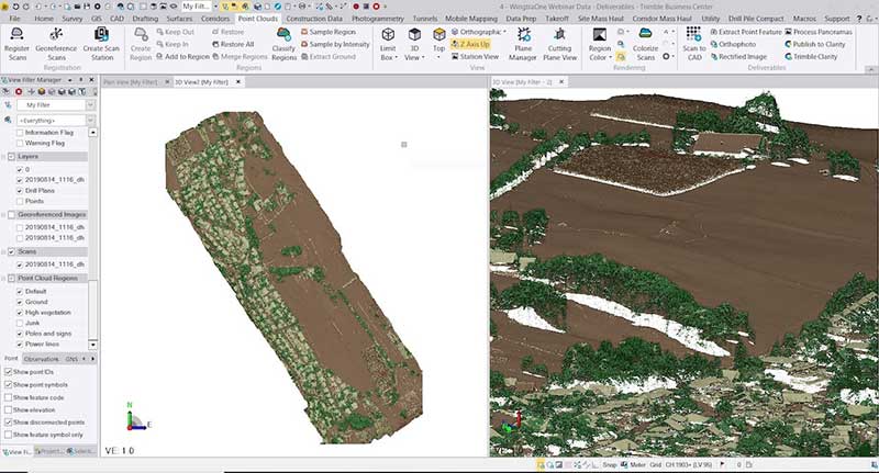
WingtraOne drone data can now be directly imported into the Trimble Business Center (TBC). The new integration combines WingtraOne high-accuracy drone data within TBC, optimizing drone mapping workflows for survey and construction projects within a single software platform. After dragging and dropping the JobXML data file, automated point cloud tools, such as classification and feature extraction, can quickly generate surface models, topographic plans and as-built deliverables. Also new: high-altitude flight capabilities, longer flight times and more intuitive battery-level readings in-flight.
The Snoopy CL-360 lidar scanner. (Photo: Lidar USA)
The Snoopy CL-360 has been meticulously designed for integration on backpack, vehicle and UAV applications. Weighing 5 kilograms fully assembled, the Snoopy CL-360 is capable of delivering highly accurate results, up to +/-0.01 feet on paved surfaces from a vehicle. The system has a scan line rate of 250 Hz with a 500-kHz data rate, giving a uniform result along and across track. The system is easily configurable with multiple scanners (similar to internet of things applications) to avoid occlusions. A UAV deployment achieves scans with usable data as much as 60 degrees off nadir (widths of more than 1,100 feet while scanning at the 400-foot ceiling). The small beam size of 0.3 mrad allows the CL-series to reliably collect ground points (such as on or near the dirt through vegetation) while also providing better detection of fine linear features such as power lines and railroad tracks.
The E300 Pro receiver tracks GNSS with 700 channels and fully supports BDS-3 signals. It supports 31 frequency points, using all GNSS constellations and frequency bands. The E300 interface has a concealed design for better protection. USB type-C charging and transmitting is a two-in-one function. The magnesium-alloy body is rugged, and the battery level can be checked with a unique LED power indicator. The weight of the whole receiver is 940 grams. The E300 Pro supports satellite station differential and satellite chain life, quick connection, intelligent voice and tilt compensation. It integrates multiple sensors including GNSS, an inertial measurement unit (IMU), a magnetometer and a thermometer. With the help of a Kalman filter algorithm, the device can dynamically output position, speed and attitude information. It can measure and make real-time dynamic sampling without the need for leveling. For better radio signal quality, the E300 Pro integrates GNSS, Bluetooth, Wi-Fi, 4G main and auxiliary antennas on the top of the receiver to ensure the best reception in all directions. An RF connector improves connection reliability while reducing loss of gain.
The Nova MS60 MultiStation combines upgraded, fast 3D laser-scanning capabilities, GNSS connectivity and digital imaging with a high-end total station. It features a fast laser-scanning speed of up to 30,000 points per second, optimized scan area definitions, adapted scan managements, and an improved scanning path for zenith scans. Professionals can perform point-cloud analysis in the field. Scan data is combined with traditionally measured points from GNSS receivers to graphically show locations the same day it is collected.
CP Aeronautics, a new division of CP Technologies, has launched integrated turn-key solutions based on unmanned aerial systems (UAS) platforms, payloads, data links, ground control stations (GCS) and communications for defense and civil applications. The systems offer operationally proven solutions for intelligence, surveillance and reconnaissance (ISR) systems requirements. Its broad product portfolio has demonstrated excellent performance and operability in demanding environments, the company stated in a press release. Backed by continuous research and development, the systems are built on three decades of technological and operational experience. Systems include Orbiter 2 Small UAS, Orbiter 3 Small Tactical UAS, Orbiter 4 Small Tactical UAS (pictured), Aerostar Tactical UAS, Dominator XP (medium-altitude long-endurance) and Pegasus 120 (vertical takeoff and landing).
A new flight control system (FCS) fits and leverages multi-mission, multi-domain UAV platforms. Using the FCS, the new Saker-1B Medium Altitude Long Endurance (MALE) UAV performs with fully autonomous online and offline operation, from takeoff to landing. Testing included more than 500 hours of day and night test missions under various weather conditions, including extremes of dust and heat. A total of 1,000 hours of take-off and landing test missions were successfully performed, with long-endurance flights lasting up to 19 hours. The Saker-1B is equipped with a satellite communication data link for beyond-visual-line-of-sight (BVLOS) operation. The FCS provides sustainability to jamming attacks and advanced data security.
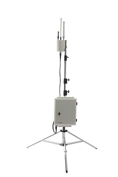
VigilAir is an RF-based system of deployed sensors able to accurately detect, geolocate and track commercial drones and their operators in different environments, including dense urban environments. VigilAir provides extremely sensitive detection and highly accurate geolocation and tracking over very large areas, with virtually zero false-alarms. Being a passive, receive-only system, VigilAir can easily be installed and operated without regulatory or legal limitations. The VigilAir version 2.0 C-UAS (counter unmanned aerial system) is certified by the United Kingdom Center for the Protection of National Infrastructure (CPNI) under the CPNI’s Counter Unmanned Aerial Systems Detect, Track and Identify (DTI) testing and evaluation standard. VigilAir generates a comprehensive drone situational awareness which enables users to proactively and intelligently match correct mitigation actions with actual drone threats, on time and with minimal collateral effects.
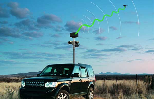
Xpeller Rapid — the mobile version of the counter UAV solution Xpeller — uses a combination of radar, electro-optical sensors, rangefinders and jammers to protect against threats posed by over-the-counter drones. Xpeller Rapid is either integrated into a vehicle (mast solution) or comes in transport boxes and can be easily set up on tripods. Based on the Xpeller toolkit, the components follow the detect, identify, control and act workflow, defeating hostile drones at ranges up to several kilometers. The system can locate and classify even small hobby drones at a range of several kilometers. High-resolution cameras make it possible to decide whether there is a serious threat so that it can be countered with appropriate countermeasures.
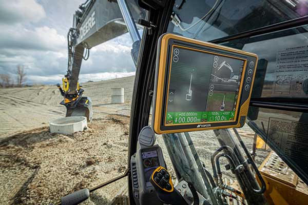
Topcon Positioning Group is offering a new Thermal Mapper for asphalt paving. It is designed to monitor temperature segregation to prevent future problems and measure performance, as well as provide accurate compliance reporting — all with real-time kinematic (RTK) positioning accuracy.
The mapper records temperature readings behind an asphalt paver as the paving is in progress and provides a visualization to operators in real time of whether the mix falls within a predefined temperature range, and if any segregation is limited within specifications.
“If too much segregation occurs, roads will soon develop major problems. The mapper quickly tells operators if the mix is stable or if moderate or severe temperature variation is occurring. If the readings are unacceptable, operators can adjust for more efficient and accurate project outcomes,” said Murray Lodge, senior VP of construction. “The system’s sensors also bring to the market the first thermal mapping system with RTK GPS positioning for more accurate results than conventional methods.”
The system also creates data reporting files to download for applications such as U.S. Department of Energy compliance through an interactive Pavelink module, the Topcon cloud-based logistics application for asphalt paving.
“We are excited about where Topcon is taking the paving industry with the different solutions we are bringing to market. From SmoothRide, where we scan the existing road to determine the optimal design for variable depth milling and paving to the newly released Pavelink system, we are focused on improving paving.
“Pavelink allows contractors to monitor the entire paving workflow from the batch plant, mixing plant, trucks, to the paver, to the rollers. By connecting the entire process, it allows the contractor to have full control over their projects in real time and make adjustments along the way, instead of after the fact as is so often done with conventional methods. Now, bringing in the heat sensor system into that workflow, we are giving contractors more resources to meet the specifications demanded today.
“It is part of our commitment to revolutionize the planning and management of the asphalt paving process with real-time visibility throughout the project lifecycle,” Lodge said.
The competition promotes the use of GNSS and Earth observation in European and African agriculture
The European GNSS Agency (GSA) is bringing back the Farming by Satellite Prize. Registration is now open for young innovators to explore the use of satellite technologies in agriculture to enable sustainable farming practices, improve efficiency and reduce the environmental impact.
The Farming by Satellite Prize is a joint initiative with the European Environment Agency (EEA), the European Union agency that provides independent information on the environment to decision makers and the public. The EEA also manages the Copernicus Land Monitoring Service and cross-service in situ coordination.
Innovation is crucial for the growth and sustainability of the agricultural sector, enabling it to respond to emerging global challenges such as the rise of the global population and the impact of climate change.
The Farming by Satellite Prize is designed to encourage young professionals, farmers and students in Europe to create new, sustainable and environmentally friendly solutions using Copernicus, EGNOS and Galileo.
The 2020 edition of the Farming by Satellite Prize includes the Special Africa Prize, which aims to encourage young Africans to develop satellite-based solutions able to cater to the specific needs and resources of communities and lands in Africa.
“Who would have thought that Galileo and Copernicus would have convinced the young farmers to become tech-savvy entrepreneurs bringing innovation gained by space data to improve quality of life,” said Pascal Claudel, acting executive director of the GSA. “We need young farmers to be innovative to develop a competitive and yet sustainable agriculture. Of course, they take advantage of what is available thanks to space technologies and our objective with this competition is to support them to reach the best possible solution.”
“It is clear that we need to make food production much more sustainable and lessen its impact on the environment and climate,” said Hans Bruyninckx, EEA executive director. “Satellite data, technology and innovation can support this change, which is why partnering with this initiative aligns well with the EEA’s commitment to protecting our nature, climate and human health.”
Applicants can take part as individuals or as a team and are invited to register online between March 16 and June 15. The top teams will be selected as finalists to enter the deep dive phase. A total prize purse of €10K will be distributed among the top four applicants.
The 2020 edition of the Farming by Satellite Prize is supported by industry partners with the sponsorship of CLAAS, a manufacturer of agricultural engineering equipment. Full details on the competition are available at www.farmingbysatellite.eu. Participants are invited to register early and submit their full written application before the registration deadline on June 15 deadline.
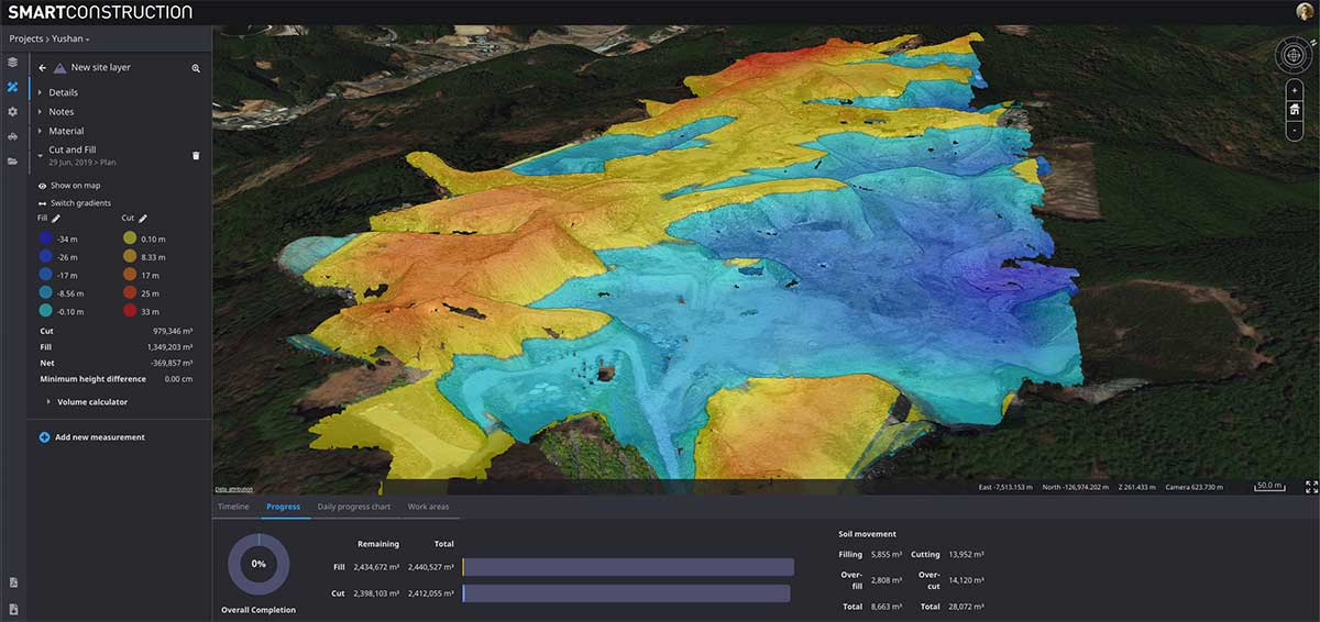
Cesium’s 3D technology will power smart construction dashboard to make construction safer, more efficient and more profitable
Komatsu has officially announced an incoming suite of the company’s Smart Construction solutions, which will include the 3D visualization power and geospatial accuracy of Cesium, a platform to visualize, analyze and share 3D data.
“Together, Komatsu and Cesium are bringing a new era of innovation to the construction industry,” said Rod Schrader, Chairman and CEO of Komatsu’s North American operations. “As experts in 3D data visualization, computer graphics and open-source software, Cesium’s technology will help power our Smart Construction Dashboard.”
Komatsu made the announcement at ConExpo 2020, held in Las Vegas.
As the key strategic partner for 3D data visualization, Cesium built the company’s Smart Construction dashboard. The dashboard enables users to monitor a construction site from anywhere in the world, see how it changes over time and compare architectural plans with real-world data.
It is compatible with different types of data — collected from sensors on individual construction machines, drone surveys, or computer generated files like BIM/CAD models — allowing users to visualize them all in a single scene within a web browser, as well as calculate precise measurements for cut and fill, slope, contours and more.
As Komatsu noted today, the worldwide construction industry is on the cusp of rapid change and innovation driven by technology. Collecting data from people and machines — and connecting all of it across an open platform — optimizes processes and delivers insights that will enable customers to make data-driven decisions.
Komatsu chose to partner with Cesium because of its powerful 3D visualization engine and accuracy in tying data to precise locations on the globe. Cesium’s ability to keep millimeter-level accuracy while tracking satellites in complex orbits was important to attain the level of precision Komatsu’s Smart Construction initiative demands.
“We believe in Komatsu’s vision to create construction sites that are safer and more efficient through Smart Construction.” said Cesium CEO Patrick Cozzi. “We are proud that visualization and analytics with the hallmark precision of Cesium will provide technology for the industry’s digital transformation.”
Tilt rotation support for automatic excavation, bring-your-own device, mobile apps included
Topcon Positioning Group announces advances to its portfolio of machine control solutions that are designed to provide contractors with better performance and profitability in earthmoving applications. The new solutions include tilt rotator functionality for the Automatic Excavator system, mobile and bring your own device (BYOD) display options, and other additions.
Topcon made the announcement at ConExpo, taking place this week in Las Vegas.
Tilt and rotation for Automatic Excavator
Photo: Topcon
Advanced tilt rotator functionality will allow Automatic Excavator operators to easily swivel or tilt the bucket with automatic boom control for faster and more efficient excavation.
“If excavator operators are in situations such as at the top of the slope, grading a long incline and not totally perpendicularly lined up, positioning the cutting edge of the bucket to the surface is now more easily attainable with the tilt rotator functionality,” said Murray Lodge, senior VP of construction.
“Operators can excavate more quickly, moving the excavator fewer times, with less wear and tear on the chassis — all with the proven hydraulic, automated control the system offers,” Lodge said. “It is also extremely beneficial when navigating around manholes, trenches, and generally tight spaces.
“We have had tilt rotation functionality for a number of years, but in previous systems,” he said. “Now, it will be available for the Automatic Excavator as well. Operators are ready for this tool, and once they see the new capabilities it will bring, they will not want to work without it.”
Bring your own device – MC Mobile
Photo: Topcon
Another resource in the small excavator and compact track loader machine control offering includes bring your own device (BYOD) options that can work as a substitute for control boxes in some applications. This solution incorporates the same hardware for Topcon 3D machine control with an indicate-only option running on Android devices with a free app, Pocket-MC, which is part of the new MC Mobile system family.
“Pocket MC can be downloaded from the Google Store and used right from a phone or tablet either as a simple entry-level machine controller option for contractors who want an inexpensive way to speed up the productivity of their fleet, or as a backup on the job site to a fully featured controller — so, operators are still working, timelines keep moving,” Lodge said.
Pocket MC also allows for a local positioning system (LPS) option for excavation. Now, an LN-150 Layout Navigator total station can be used as an economical alternative to fully featured traditional total stations.
Sitelink3D enhancements
Enhancements also have been made to the Sitelink3D job site monitoring and management system, including a pay-as-you-go point-based service model and a Haul Truck app, giving contractors more visibility into workflow management and the flexibility to use it in the way that best fits their operation.
“These latest releases strengthening the earthmoving portfolio are part of our commitment to continually developing greater connectivity and automation for today’s job site to accelerate efficiency across all aspects of a project,” Lodge said.
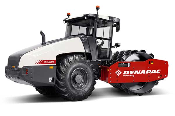
Dynapac and Trimble are partnering to develop commercial-ready autonomy functionality for Dynapac soil rollers.
The companies first demonstrated automation of the soil compaction process at this week’s ConExpo 2020 in Las Vegas, and plans another demonstration during the Trimble Dimensions User Conference Nov. 2-4 in Nashville, Tennessee.
The Dynapac CA3600PD single-drum vibratory roller. (Photo: Dynapac)
Dynapac’s “Road to Autonomy” was launched with the introduction of Seismic Soil Rollers in 2019. The Dynapac-exclusive Seismic technology takes the guesswork out of the equation for operators, regarding soil type or frequency settings, the company said.
Dynapac Seismic monitors the soil properties and automatically adjusts the frequency of vibration for optimal compaction and energy efficiency. The Active Bouncing Control System automatically cuts off the vibration of the drum when the material reaches maximum compaction characteristics.
The next step on the “Road to Autonomy” is automatic steering and speed functions on the roller. The operator/site manager can use the machine to map the boundaries of the area to be compacted.
Once the machine is placed in autonomy mode, the system will take over the controls for steering and speed. This functionality will be shown at the Dynapac and Trimble booths during ConExpo 2020.
By automating these functions, operator skill gaps can be bridged, while consistent speed and steering improve compaction quality results.
The autonomous solution is built on Trimble’s control platform and utilizes Trimble’s field-proven positioning technology. Compaction documentation systems, such as Dyn@lyzer or Trimble CCS900 Compaction Control System, work together with automatic speed and automatic steering to provide documentation of the improved quality.
Trimble’s Earthworks Grade Control Platform version 2.0, unveiled at ConExpo-Con/Agg 2020, includes new features for all machine types.
Trimble also released the Trimble Earthworks Assistant App for in-cab learning material.
ConExpo-Con/Agg 2020 is North America’s largest trade show for construction machinery, building material machines, mining machines, construction vehicles and construction equipment. The Trimble booth is located in the Las Vegas Convention Center North Hall #N-1140.
New Features
The improvements are designed to enable faster return on investment, increase productivity and decrease training time for operators.
Horizontal Steering Control for dozers automatically controls the machine to follow any horizontal alignment such as a back of a curb, breakline, roadway centerline or bottom of slope, without operator assistance.
Augmented Reality for excavators enables users to easily understand 3D models, cut/fill information, slope data and other bench points and reference points on the in-cab display in context, without the need to interpret complex 2D plans or stakes.
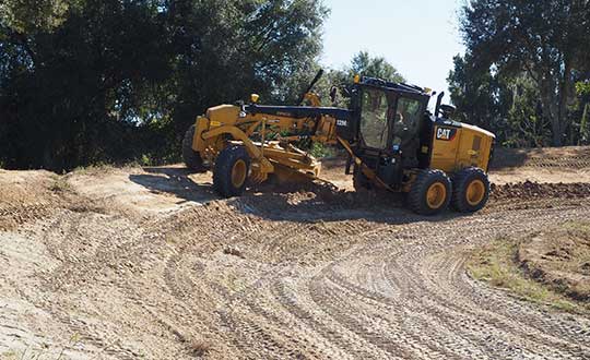
A new mastless motor grader configuration gives operators an improved range of blade motion, allowing for machine control in applications where it was previously not possible.
Integrated Trimble Loadrite Payload Management displays grade control and accurate payload data on one screen, increasing mass haul productivity and efficiency by preventing underloading, and improving safety by avoiding overloading. Contractors can maximize their investment in Trimble Earthworks by leveraging the versatility of these added options.
Trimble Earthworks is also now available for compact grading attachments with dual GNSS, single GNSS and total station guidance options.
Horizontal Steering Control for Dozers
Horizontal Steering Control allows the operator to focus on the grade and machine productivity rather than worrying about steering, reducing operator fatigue and errors. It enables the machine to follow the horizontal guidance from the 3D model, providing operators increased awareness of their surroundings, better accuracy and improved productivity with decreased overlap and fewer passes.
“Trimble is on the forefront of innovation and cutting-edge technology along the path to automation,” said Scott Crozier, vice president, Trimble’s Civil Engineering and Construction. “Using proven steering technology from Trimble Agriculture, we are continuing to advance construction machine control yet again.”
Mastless motor grader
A new mastless motor grader configuration gives operators an improved range of blade motion. (Photo: Trimble)
Trimble Earthworks for motor graders mastless configuration mounts one GNSS receiver on the cab and one on the gooseneck of the machine to eliminate masts and cables traditionally located on the blade. Mastless GNSS receivers are ideal for the blade’s maximum range of motion, which is needed for steep slope work and complex designs with tight tolerances. The new configuration enables contractors to decrease risk of damage to the machine, keep valuable receivers safer as well as reduce the time needed to remove and reinstall them each day.
Augmented reality for excavators
Augmented Reality was first released in the Trimble SiteVision™ system and is now available on excavators with Trimble Earthworks. Using a camera mounted on the outside of the machine, operators can view 3D models in a real-world environment at a true-life scale, in the context of existing surroundings. On the Trimble Earthworks display, the model is overlaid onto the existing ground giving the operator a better understanding of the work that needs to be done. Visibility of the bucket gives operators better situational awareness to be able to keep surrounding people and objects safe.
“With the intersection of physical and digital worlds, Trimble is empowering contractors to accelerate their business,” said Cameron Clark, business area manager, Trimble’s Civil Engineering and Construction. “Augmented Reality simplifies complex concepts by allowing users to see a blend of digital content and real-world environments.”
Earthworks Assistant App
Trimble now has an easier way to access critical Earthworks learning material and documentation, allowing for a shorter learning curve and less downtime for operators. This stand-alone app consolidates and simplifies access to training guides and videos inside and outside of the cab. The Earthworks Assistant App makes it easy to learn and troubleshoot using an Android cell phone, even from remote sites.
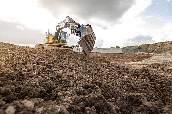
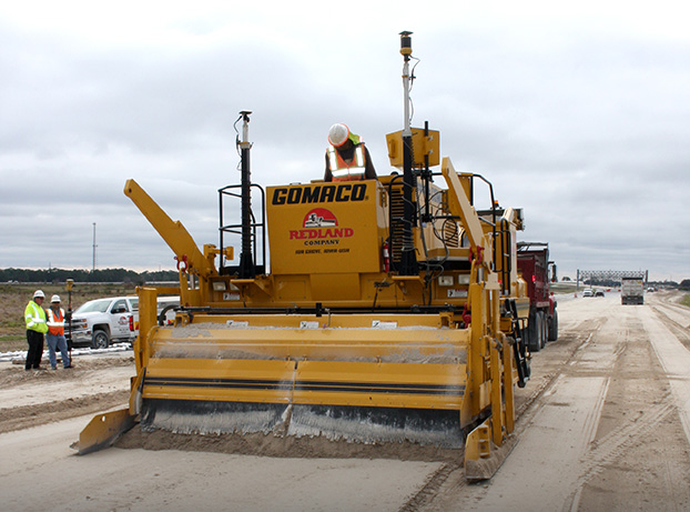
GNSS, coupled with inertial systems and software, is enabling greater accuracy in construction and agriculture. Other markets using machine control include unmanned vehicles, mining, surveying, mapping and defense.
At construction sites, GNSS receivers can be found in heavy equipment such as bulldozers, excavators, graders and pavers. On farms and in orchards, GNSS increases productivity of machines ranging from tractors to UAVs.
A new MarketsandMarkets report predicts the machine control system market will grow to $6.6 billion by 2024, a compound annual growth rate (CAGR) of 8.16%.
For precision agriculture, the outlook is even brighter. Grand View Research anticipates the market will reach $12.9 billion by 2027, a CAGR of 13% over the period.
Machine control speeds projects and increases efficiency under tight timelines. Using GNSS to guide the heavy lifting also alleviates safety concerns related to workers and construction machinery, and provides situational awareness to field operators.
In this month’s feature, we share case studies from companies that specialize in these markets, provide product details, and review the status of real-time kinematic (RTK) GNSS in agriculture.
Check out some use cases for how GNSS, inertial systems and software are enabling greater accuracy in construction and agriculture.
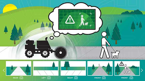
New BOLT platform enables equipment manufacturers to automate outdoor jobs, adding autonomous navigation, connected sensors and real-time operations to machines.
Left Hand Robotics, a manufacturer of self-driving smart robots for commercial turf and snow, has launched BOLT, a technology platform that transforms outdoor machinery and power equipment into smarter, more efficient, ready-to-work robots.
BOLT brings autonomous navigation, connected sensors, and real-time robot operations to outdoor power equipment and machines doing repetitive jobs across the globe. Building on Left Hand Robotics’ field-proven experience with its own robot tractors, BOLT allows OEMs to launch faster, reduce R&D costs, and tap into a unified platform with navigation, sensors, controls, software and apps.
BOLT focuses on several key areas to help with machine automation, including:
autonomous navigation and telemetry
smart sensors and cameras
connected power equipment and controls
cloud-based robot operations center and apps
job planning, reporting and analysis
Because each OEM is likely to have different requirements or product needs, BOLT partners go through multiple deployment phases, including evaluation, development and deployment.
Partnering with OEMs. Left Hand Robotics soft-launched BOLT earlier this year and interest has been high from manufacturers needing more automation capabilities. The company is now collaborating with power equipment and machine manufacturers to incorporate BOLT features into their future product lines.
“Our team has learned a lot, building, testing, proving how autonomous tractors can work on tedious, dirty jobs in the real world. These are tough problems to solve and we have already invested more than 80 engineering years into the technology behind BOLT,” said Terry Olkin, CEO for Left Hand Robotics. “We’ll continue to build our own robots while offering BOLT to a limited number of OEMs in the first year.”
Topcon Agriculture and CropZilla have signed a licensing agreement for use of the Topcon Agriculture Platform (TAP) application programming interface (API) in the CropZilla Web Mobile Analytics platforms.
TAP is a software-to-software interface designed to benefit the end-user by providing a simple and seamless way for sharing data between software systems.
With the Topcon interface, CropZilla is able to acquire machine data from a common device on the machine, adding simplicity and value to each grower wanting to utilize both tools to manage data. Users simply create an account with TAP and CropZilla and the data sharing is effortless, the companies said.
“Topcon’s strategy as it relates to our new digital solution platform is one of partnerships, connectivity, and collaboration. This partnership with CropZilla is the first step of several towards deeper integration with a premier colleague and embodies our philosophy ideally. It demonstrates that two companies can collaborate to provide additional value to the producer, dealer, and OEM,” said Brian Sorbe, VP and GM for Topcon Agriculture.
Brian Watkins, CEO of CropZilla, said, “We’re excited to add Topcon Ag to our expanding ecosystem of partners for CropZilla. We have a common desire with Topcon to create immense value to growers as painlessly as possible. This is only the first step and is a great example of that in action.”