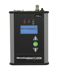
Hemisphere GNSS has rolled out the R330 GNSS receiver, a versatile, fully featured positioning system. R330 delivers accurate and robust positioning through a variety of differential correction methods including SBAS, L-Band, Beacon and RTK, the company said. With its wide range of functionality and ease of use, the R330 is suitable for a variety of land and marine applications.
The R330 GNSS receiver combines the functionality and front panel display of all previous R-series products. Customers can start with sub-meter positioning accuracy and upgrade the receiver with subscriptions that add functionality and improves performance capability to centimeter-level accuracy. To provide the most reliable solutions, R330 is capable of tracking multiple frequencies and multiple constellations including GPS and GLONASS. Users can easily switch between the various DGPS correction options without any downtime. The R330 GNSS receiver is compatible with many of the Hemisphere GNSS’ multi-frequency antennas.
The small, rugged receiver includes a display and status indicators for a user-friendly experience, Hemisphere GNSS said. A standard USB flash drive can be used for data logging.
“The functionality and performance of the R330 receiver can be custom-fit to positioning applications such as pipeline, marine, and volumetric surveys, GIS mapping, vehicle tracking, machine control, meter monitoring and many others,” said Ron Ramsaran, senior product marketing manager at Hemisphere GNSS. “R330 customers will benefit from the reliability, value, and upgrade options that can be added to meet changing needs.”
R330 features Hemisphere GNSS’ exclusive Eclipse SureTrack technology, enabling a more robust RTK solution with fewer dropouts in congested environments and a fast reacquisition when dropouts do occur. Long-range RTK baselines of up to 50 km are achievable with R330.
The R330 GNSS receiver will be available in June through the Hemisphere GNSS Precision Products global dealer network.
u-blox, provider of wireless and positioning semiconductors, software and solutions, announces that its LISA-U200 and LISA-230 6-band UMTS/HSPA+ module series as well as LISA-U270 dual band module has achieved Certified M2M Hardware status by Vodafone, the world’s second largest mobile telecom company. Vodafone owns and operates networks in more than 30 countries and has partner networks in over 40 additional countries.
The certification allows global customers to design LISA-U2 modems into M2M devices operating over Vodafone’s extensive 3G network in Europe, Asia, Africa, Australasia and the Americas. Main applications include vehicle and asset tracking, industrial automation, metering, and security devices.
The LISA-U2 series is a multi-band 3G module series in LCC package delivering high data-rates (5.76 Mb/s uplink and up to 21.1 Mb/s downlink) with voice and data capabilities. They are compatible with consumer, automotive and industrial applications. For telematics applications such as fleet and asset management, the module provides easy integration with u-blox GPS, GLONASS and QZSS receivers. The modules are compatible with all UMTS bands used worldwide.
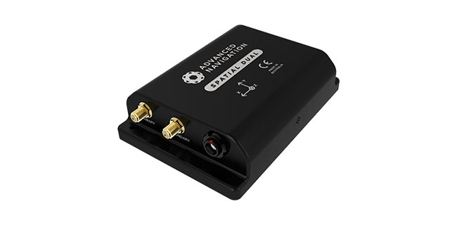
Advanced Navigation has released Spatial Dual, its new dual-antenna GNSS/INS. Spatial Dual is a ruggedized miniature GPS-aided inertial navigation system and AHRS that provides accurate position, velocity, acceleration and orientation under demanding conditions. It combines temperature calibrated accelerometers, gyroscopes, magnetometers and a pressure sensor with a dual-antenna RTK GNSS receiver. These are coupled in a sophisticated fusion algorithm to deliver accurate and reliable navigation and orientation, the company said.
Spatial Dual contains the Trimble BD982 GNSS receiver, which is a triple frequency dual-antenna RTK GNSS receiver. Using dual-frequency moving baseline RTK, Spatial Dual is able to provide heading accuracy of less than 0.1 degrees using its dual antennas. The dual-antenna heading works while both stationary and moving and allows for very accurate heading in both slow moving and 3D vehicles, where equivalent single antenna systems must rely on magnetic heading. An additional benefit of the dual antennas is the ability to measure slip angle to within 0.2 degrees.
Spatial Dual supports all of the current and future satellite systems, including GPS, GLONASS, Galileo and BeiDou. In addition, Spatial Dual supports RTK for centimeter positional accuracy and the recent Omnistar G2 network for 10 centimeter accuracy.
Spatial Dual provides position, velocity and orientation at rates up to 1000 Hz for highly dynamic applications. When Spatial Dual loses a GNSS fix it continues to navigate using dead reckoning inertial navigation to provide seamless navigation data through tunnels and other outage situations.
Spatial Dual is housed in a precision marine-grade aluminum enclosure that is waterproof and dirtproof to the IP67 standard and shockproof to 2000g, allowing it to be used in tough conditions.
Spatial Dual supports a wide range of peripherals including odometers and wheel speed sensors for ground vehicle navigation, DVLs and USBLs for underwater navigation and many other external sensors. It supports both industry standard NMEA output and an efficient binary protocol.
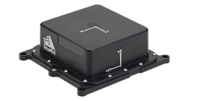
NovAtel Inc. has announced a new SPAN-IGM series of Micro Electromechanical Systems (MEMS) inertial sensor products, including the IMU-IGM-A1 MEMS enclosure and the SPAN-IGM-A1 GNSS/INS enclosure.
The IMU-IGM-A1 is a small, rugged enclosure that houses a MEMS inertial sensor. The IMU-IGM-A1 can be configured from the factory as an integrated GNSS + Inertial Navigation System (INS) or as a standalone IMU sensor for pairing with a customer’s existing NovAtel SPAN enabled OEM6 receiver. Featuring regulated 10-30 VDC input and a dedicated wheel sensor input to enhance GNSS outage bridging capabilities, the IMU-IGM-A1 delivers a 200 hertz navigation solution and raw measurement output.
“The IMU-IGM-A1 is the smallest, lightest IMU enclosure in our SPAN GNSS/INS product portfolio,” said Jason Hamilton, director of marketing for NovAtel. “It provides NovAtel customers with the ability to leverage our powerful SPAN technology in new applications that are size and weight constrained but still require highly precise position, velocity, roll, pitch, and heading.”
The SPAN-IGM-A1 combines NovAtel’s OEM615 GNSS receiver card with a MEMS inertial sensor in a single enclosure. By integrating the MEMS IMU with NovAtel’s tightly coupled OEM6 GNSS/INS SPAN engine, advanced positioning options such as AdVance RTK, ALIGN heading technology and RAIM are available to maximize performance.
Shipments of the new IMU-IGM-A1 enclosure and the SPAN-IGM-A1 GNSS/INS integrated enclosure commence early Q2 2013.
It used to be that professionals using precision GNSS applications had to go to the expense of buying, operating, and maintaining RTK base-stations and radio set-ups. Then L-Band corrections came on the scene and things changed. Most precision receiver manufacturers supply an L-band option for a nominal fee, and also sell PPP service subscriptions. There are now a number of PPP correction service providers offering higher precision, including a couple of new options.
As a quick overview — L-band is just like WAAS, but with privately owned assets, rather than provided by a state agency. WAAS focuses on high integrity and accuracy, while L-band corrections are largely more focused on providing accuracy to users. A geographically distributed ground network of base stations sends receiver data to one or more central processing facilities, which formulate wide area corrections. A number of uplink stations then send these corrections up to geostationary satellite transponders (time on a number of satellites is often rented, but L-band companies could also own and operate their own satellites), and the transponders transmit the wide area corrections at L-band frequency for reception by suitably configured user receivers. Users are able to buy subscriptions that enable them to receive corrections for a period of time — and that’s how the private L-band suppliers make money. The accuracy a user can achieve depends on the service, but anything from a few meters to a few centimeters is now possible.
Before WAAS was fully operation in the U.S., L-band corrections supplied by private companies were already available. It became possible to regularly get meter-level accuracies without base-stations, and it was clear that this could well turn into a major benefit for users. Operations like agricultural automation, asset tracking, mining, marine navigation, and others that could get by with a few meters of accuracy began to rely on L-band corrections. Geographic Information Systems (GIS) could even work without base stations, and vehicle tracking could determine which side of the road a truck was on. Then with expanding worldwide ground networks, more satellites and ever-improving clock and orbit algorithms, we started talking about corrections that gave us decimeter accuracies. That’s when PPP began to outpace WAAS for some applications requiring higher precision.
Never quite got the significance of why the original marine PPP companies were spinning off land-focused providers from their marine businesses, but the original marine correction providers now have successfully established “land-only” provider companies. It makes sense to have a supplier talk to you in marine terms if you’re running a shipping company, and for that provider to focus on providing higher integrity corrections to your shipping fleet. Land-based machine control, GIS and vehicle tracking outfits, on the other hand, want their own land-based support networks and don’t want to talk in marine terms. So we now have a number of providers supplying different sets of PPP corrections. It’s also possible that segment pricing for the different markets might have played a role in these spin-offs.
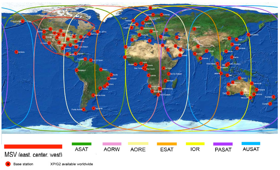
The granddaddy system would seem to be Fugro’s OminSTAR — whose services are now marketed by Trimble following acquisition of OminSTAR marketing rights by Trimble in 2011, while Fugro retained its marine services. OminSTAR HP, G2, XP and VBS services are available courtesy of a worldwide network of reference stations, data networks, carrier-phase measurements and sophisticated “clocks and orbits” correction algorithms which provide sub-meter thru 10-cm capability to users.
The OmniSTAR network.
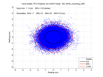
And of course Trimble is also running its own RTX service alongside OmniSTAR. With a world-wide reference station network, and a number of concentrated regional networks, CenterPoint RTX is regularly achieving less than 4cm for users. RTX is available over regular L-band satellite and over internet. Overall an impressive PPP capability.
The CenterPoint RTX network, by Trimble.
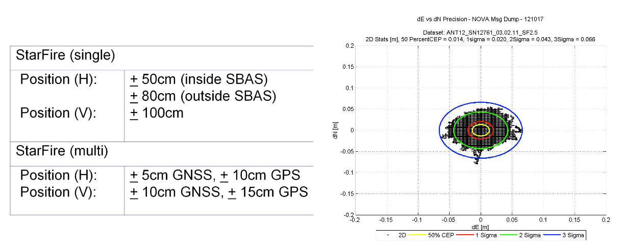
Then NavCom — and Deere & Co, its parent company — fielded the StarFire system for both NavCom and John Deere customers, who not surprisingly use it mainly for agriculture. However, use of the system has grown since it was introduced in 1999 and currently around 10 percent of customers are in markets other than ag — in offshore, survey, construction, aerial, GIS, and government/military applications. The StarFire signal is available worldwide but NavCom offers two differently priced services: “Land Only” and “All Area” for non-ag applications. You have to have Navcom or John Deere equipment to be able to use it, but the network and the receivers come from the same people, so the system has been optimized for peak performance and there shouldn’t be concerns about third-party integrators or service providers.
In 2001 in collaboration with JPL, Real Time GIPSY (RTG) was combined with the existing StarFire clocks and orbits algorithms and a StarFire GPS 10-cm service was offered. Nowadays StarFire GNSS has evolved out of that original correction service and claims impressive 5-cm accuracies using its multi-constellation GPS and GLONASS corrections.
The Starfire GNSS network.
StarFire also uses over 80 reference stations with mostly GPS/GLONASS receivers providing carrier phase data for redundant processing and distribution by L-band transmissions over the Inmarsat satellite network.
Then we come to the latest entrant into the land PPP business – TERRASTAR. The parent company Veripos has been around since 1989 and has been extremely successful in its marine business, going public in 2012 on the Oslo stock exchange. Veripos recently launched TERRASTAR to better address the land market for all the same good reasons discussed earlier. TERRASTAR provides two correction services: –M is meter level DGNSS and –D is a decimeter solution using both GPS and GLONASS. All the 80+ owned and operated reference sites around the world have dual-frequency GPS/GLONASS receivers, and there are plans to add Galileo and even COMPASS in the future.
Dual-redundant processing and network servers ensure uninterrupted distribution of GPS and GLONASS orbit and clock corrections, enabling decimeter accuracy for users. TERRASTAR distributes corrections over all seven Inmarsat GEOs, providing most land users with redundant L-band visibility.
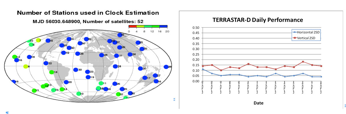
Correction quality and availability are largely dependent on the number of reference stations that track the same GNSS satellite. The figures below show the location of satellites at a given time and the number of stations simultaneously tracking those satellites. For the TERRASTAR ground network, there are often more than 30 stations tracking the same satellite. This makes for high-quality clock and orbit corrections, and TERRASTAR-D claims to provide consistent, stable horizontal 5-10 cm and vertical 10-15 cm performance.
The TERRASTAR network.
As a new player, TERRASTAR has yet to corner a whole bunch of customers, but it already has some significant customer applications. It “GEO-Gates” its corrections like other providers to ensure usage on land, but it extends coverage to land areas plus about 6 km beyond the coastline — termed “nearshore.” So TERRASTAR has been able to capture in-shore dredging and construction business in Europe that otherwise might have had to go to more expensive marine correction services.
In addition, a new customer is using TERRASTAR for airborne geophysical applications. There are also ongoing trials on excavators in road construction, on trains, in oil and gas, for GIS/surveying, and with integrated agricultural sprayer-control and harvesters. TERRASTAR plans shortly to offer a web-based e-Commerce System for users to control their subscriptions. TERRASTAR and Septentrio/Altus have long-term relationships for receivers/systems, and Septentrio and Altus also retail the TERRASTAR service.
So, just when you think you have a good picture of PPP, another option for users has started to show up. PPP over internet — or iPPP as Nexteq Navigation in Calgary, Canada terms their service – is designed to provide similar corrections as PPP, but over cellular phone or Wi-Fi connection to the internet, rather than over satellite. With single frequency GPS, Nexteq claims accuracies of around 50cm, and 10cm with dual frequency, although their T5 and T5A handhelds only currently support L1. Of course Trimble has had corrections over the internet for a number of years.
So its clear that PPP services continue to evolve and become more and more sophisticated to match the growing complexity of customer applications. And as achievable accuracies improve, we’re seeing use in higher precision applications which would have seemed impossible just a few years ago, where local RTK base-stations and radio links would have been the only way to go.
With several very capable sources to choose from, GNSS industry customers have several options to carefully assess and fit to their business. Each PPP supplier has specific advantages and features available to meet customer expectations. The market now appears to be large and specialized enough that its inviting for new entrants. And each new entrant seems to bring with them new twists and capabilities which sell their services. As a customer, it’s a good time to trial new precision applications with PPP.
NovAtel’s new SMART6-L GNSS antenna integrates its OEM6 engine with Pinwheel antenna technology. Tracking L1 and L2 GPS + GLONASS, the SMART6-L delivers scalable performance, from single-frequency GL1DE smoothing performance to centimeter-level accuracy using dual frequency real-time kinematic tracking. Optional L-band tracking improves positioning accuracy outside of L1 SBAS coverage areas.
The SMART6-L is designed for manual guidance and auto-steer agriculture applications that benefit from ultra-smooth positioning and high pass-to-pass accuracy. The dual-frequency GL1DE firmware enhances the absolute accuracy of the GL1DE position, creating a robust solution and mitigating the effects of high ionospheric activity, NovAtel said. The design of the SMART6-L interface maximizes flexibility with NMEA 0183 compatible RS-232 serial ports and a NMEA2000 compatible CAN port. One PPS output, an event mark input, and three daylight readable status LEDs are also provided. Built-in magnets simplify mounting although fixed mounting options are also available.
The SMART6-L is available for order starting March 18, with product shipments commencing April 15.
Swedish-based Handheld, maker of mobile computers designed for extreme environments, has integrated u-blox’ GPS modules in four of its most popular products: the Algiz 7 and Algiz 10X tablets, Algiz XRW notebook, and Nautiz X1 smartphone. These tough computers are designed for and used in demanding environments such as polar expeditions, marine exploration, and rescue operations, as well as outdoor industrial applications such as utility maintenance and logistics. The devices depend on u‑blox’ LEA, NEO, and AMY families of compact, high-performance GPS modules to provide reliable navigation and positioning in challenging conditions.
“Handheld is proud to have achieved an industry-leading position for dependable, ruggedized mobile computers that can be trusted to work in the most hostile environments” said Jerker Hellström, CEO Handheld Group, “To achieve this extremely high-level of performance, we only select components with the highest reliability on the market. GPS positioning is one of the most important functionalities of our products. For this mission-critical feature, we chose u-blox.”
Handheld’s lineup of rugged PDAs and mobile computers is specifically developed for use in tough environments in industries such as geomatics, logistics, forestry, public transportation, construction, mining, field service, utilities, maintenance, public safety, military and security.
SeeControl, a machine-to-machine (M2M) cloud service provider, announced today that it will add Quake Global’s Q4000 to its line of turnkey M2M solutions for agriculture and equipment telemetry.
The Q4000 is a dual-mode communication modem that will connect either to a satellite network or to a traditional ground-based wireless data network. The modem will automatically choose the most economical method of sending the data. The combined communication capabilities of the Q4000 and SeeControl’s turnkey telematics applications will allow equipment OEMs and owners to send and receive information from globally dispersed heavy equipment, harvesters, irrigation systems, fluid tanks, generators and vehicles.
“Our device store offers a vast selection of turnkey M2M sensor devices to enable mixed asset and fleet operations,” Said Bryan Kester, CEO of SeeControl. “Now, with Quake, this extends to effortless satellite and GSM connectivity in a single easy-to-deploy product. It is perfect for equipment owners that want to add new asset types to an existing global fleet, or for OEM equipment manufacturers designing the next generation of telematics programs.”
“We are very pleased to establish this relationship with SeeControl,” said Polina Braunstein, CEO of Quake. “They are a recognized leader in the agricultural OEM and Telematics solutions arena. We anticipate that considerable agriculture and equipment telematics innovation will be fueled by the global reach of the Q4000, combined with SeeControl’s software-as-a-service cloud for sensor reporting and analytics.”
The combined offering is on display at Booth P48 at the 2013 World Agricultural Expo, taking place now through Thursday in Tulare, California.
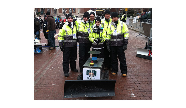
The Institute of Navigation (ION) Satellite Division held its third annual ION Autonomous Snowplow Competition January 24-27 at Rice Park in downtown Saint Paul, Minnesota, as part of the 127th Saint Paul Winter Carnival.
Sponsored by The ION Satellite Division and held in cooperation with the ION North Star Section, the ION Annual Autonomous Snowplow Competition is a national event open to college and university students, as well as the general public, that challenges teams to design, build, and operate a fully autonomous snowplow using navigation and control technologies to rapidly, accurately and safely clear a designated path of snow.
Eight teams participated in the four-day competition, each using state-of-the-art navigation systems to plow two different snowfields. Teams included students, partners from private industry and faculty advisors from Case Western Reserve University; Dunwoody College of Technology; Miami University (Ohio); Ohio University; The University of Michigan – Dearborn, and The University of Minnesota.
Teams were judged based on their cumulative scores earned throughout the competition phases: 75 percent of the total score was based upon the plowing competition; and 25 percent of the total score was based on the presentations and pre-event report.
First place was awarded to Ohio University’s Avionics Engineering Center with students Samantha Craig, Ryan Kollar, Adam Naab-Levy, Pengfei Duan and Kuangmin Li with support from faculty advisors Dr. Frank van Graas, Dr. Wouter Pelgrum and Dr. Maarten Uijt de Haag who submitted their four-wheeled Monocular Autonomously Controlled Snowplow (M.A.C.S.). The first place prize included $5,000 and a golden snow globe trophy. Ohio University also captured the Best Student Presentation Award that included $500 and the “Golden Shovel” Award and the Best Written Report that included $500 and the “Golden Pen” Award.
Second place was awarded to the Miami University team “RedBlade” that included students Mark Carroll, Chad Sobota, Robert Cole, Richard Marcus, Harrison Bourne, Jamie Morton and Michael Harris with support from advisors Dr. Yu (Jade) Morton, Dr. Peter Jamieson, Steve Taylor. The second place prize included $4,000 and a silver snow globe trophy.
Third place was awarded to the University of Michigan (Dearborn) team “Yeti 3.0” that included students Angelo Bertani, Zachary DeGeorge, Ahmed Alkirsh, Abdelqwee Yaffai, Mark Bajor, Craig Cowling, Cody Schmitt, Jacob Mack and Mengxing (Simon) Chen with support from faculty advisor Narasimhamurthi (Nattu) Natarajan. The third place prize included $3,000 and a bronze snow globe trophy.
In addition, the first place team, Ohio University, has been invited to display its winning snowplow during ION GNSS+ 2013 conference September 16-20 in Nashville, Tennessee.
Sponsors of the second annual ION Autonomous Snowplow Competition included Honeywell, Inc., Alliant Techsystems Inc., Lockheed Martin Corporation, ASTER Labs, Inc., Space Exploration Technologies Corp., The Toro Company, Proto Labs, Inc. and U.S. Bank.
The Fourth Annual ION Autonomous Snowplow Competition will be held in January 2014 at the Saint Paul Winter Carnival, St. Paul, Minnesota.
Trimble is launching a high-accuracy correction service for the agriculture market. The Trimble RangePoint RTX correction service is expected to be available in March.
According to Trimble, the RangePoint RTX service is an introductory, cost-effective correction service available to farmers across the contiguous U.S. as well as most of Canada, South America, Russia, and the Commonwealth of Independent States, Africa, Asia and Australasia. It’s designed for broadacre agriculture applications. For 2013, all compatible devices — the Trimble CFX-750 display, FmX integrated display, and the AG-372 GNSS receiver — are eligible for an introductory, free 12-month subscription to the RangePoint RTX correction service.
The new service uses satellite broadcast capabilities to deliver real-time accuracies of better than 50-centimeter (20-inch) repeatable, or a superior 15-centimeter (6-inch) pass-to-pass, and does not require the use of traditional reference station infrastructure. Trimble RTX technology supports both GPS and GLONASS satellite constellations, increasing accuracy and reliability for users by leveraging the availability of multiple satellite systems. As a result, the RangePoint RTX service can provide a more accurate, reliable correction solution than some of the traditional Satellite Based Augmentation Systems (SBAS), and is also available in certain geographic areas where SBAS is not currently accessible.
“Trimble is committed to expanding the services and software applications that we provide to the global farming community,” said Mike Martinez, market manager for Trimble’s Agriculture Division. “We recently expanded the availability of real-time, satellite-delivered corrections to most of the world through Trimble’s CenterPoint RTX correction service. Now, we are enhancing the Trimble correction services portfolio by providing an introductory RTX-based option for farmers looking for more accuracy at an affordable price point. Our customers want a broad range of solutions, and we’re delivering those options.”
Trimble RangePoint RTX real-time satellite delivered corrections can be received directly by compatible GNSS receivers, so there are no additional costs for mobile data plans or requirements for additional hardware such as radios and antennas. The RangePoint RTX service is compatible with the Trimble CFX-750 display, FmX integrated display and the AG-372 GNSS receiver.
On January 31, Hemisphere GNSS Inc., a subsidiary of Beijing UniStrong Science & Technology Co. Ltd., purchased the Precision Products business and related GNSS technology and intellectual property from Hemisphere GPS Inc. for $15 million US. In a related press release, Hemisphere GPS Inc. has announced the intention to change its company name to AgJunction.
As part of the transaction, Hemisphere GNSS acquired all of the high-precision GNSS product lines, all related intellectual property rights and the Hemisphere GPS trademarks and brands. The Precision Products segment generated revenues of approximately $13.3 million in 2012 serving marine, land survey, construction, mapping, and OEM segments.
Hemisphere GNSS will operate its business headquarters out of Scottsdale, Arizona, and will maintain its operations in Calgary, Alberta, Canada.
Phil Gabriel has been appointed president of Hemisphere GNSS Inc. and will also serve as a board member. Gabriel has more than 15 years of experience with Hemisphere GPS, serving for the past six years as the vice president and general manager of the Precision Products business. “We are truly excited about our future growth prospects as a fully focused GNSS products and technology provider,” Gabriel said. “I would like to assure all our global distribution partners, suppliers and customers that it remains business as usual as we take our first steps forward with the strong backing of UniStrong.”
With this acquisition, UniStrong is expanding its capabilities in the high-precision GNSS business and also expects to promote commercial applications of China’s BeiDou Navigation System. UniStrong is listed on the Shenzhen Stock Exchange under ticker 002383.
Business analysts have reported in China that this is the first acquisition of an internationally renowned enterprise initiated by a domestic enterprise in China’s satellite navigation industry and represents an important milestone in the development of the industry. “The acquisition will create an international route enabling UniStrong to expand its global business outlook, enhance our ability to attract international talent, and lay the foundation for international growth and profitability,” stated Xingping Guo, president and CEO of UniStrong.
As part of the agreement, Hemisphere GNSS and AgJunction have formed a strategic alliance and a collaborative business relationship covering supply chain management, customer support, technology development and cross-licensing. “Having already established a relationship with UniStrong as one of our resellers made our new alliance a win-win for both parties,” said Rick Heiniger, president and CEO of AgJunction. “I am very pleased to be working together in this close technology-sharing relationship.”
Hemisphere GNSS’s newly appointed board of directors brings additional GNSS industry experience to the company. The board is chaired by Jonathan W. Ladd, former president and CEO of NovAtel Inc. Also joining the board is Werner Gartner, former executive vice president and CFO of NovAtel Inc.
“Hemisphere’s talented team will leverage its core GNSS capabilities and product marketing knowledge with UniStrong’s high quality, low cost GNSS product design and development resources,” said Ladd. “Hemisphere’s existing and future customers and partners will most certainly benefit from the resulting rapid, cost-effective product innovation across multiple product lines.”
Beijing UniStrong is focused on GNSS industry, with R&D, production, engineering, sales and service facilities. Its technical solutions and products cover GPS/GLONASS/COMPASS receivers, multi-system navigation and positioning, high-accuracy surveying, GNSS data post-processing, and system integration.
The re-branding of Hemisphere GPS as AgJunction is an integral part of the strategic re-focusing of the company’s resources on precision agriculture, and part of the restructuring initiated in September 2012. The company maintains ownership of its key patents and leading agricultural brands including AgJunction, Outback Guidance, and Satloc.