Trimble has added advanced line acquisition technology to its Autopilot automated steering system Trimble OnSwath technology. The acquisition technology reduces the time lost turning at the end of a row by enabling the vehicle to make a tighter turn and approach the next line, or crop row, 50 percent faster.
Using OnSwath, the farmer can decrease idle driving time, fuel consumption, soil compaction, crop damage, and working time in the field — which can lead to cost savings. OnSwath is a free upgrade to customers using the Trimble Autopilot automated steering system.
The new OnSwath technology allows the user to customize their line acquisition to the vehicle, operation, and operator preference including adjusting turn angle, approach angle, and speed. Using OnSwath, the vehicle projects its path to the line, which allows it to get online faster. As a result of these improvements, vehicle performance is more controlled, predictable, and repeatable.
“By adding OnSwath to Trimble’s Autopilot steering system, we’ve enabled farmers to be more efficient with their field operations,” said Erik Ehn, Smart Machines business area director of Trimble’s Agriculture Division. “OnSwath saves time, money and fuel, while also decreasing soil compaction and crop damage. Since we’re providing the technology at no additional cost, farmers who use Trimble’s automated guidance can leverage OnSwath and measure how much it can save their farm.”
“With Trimble’s OnSwath, I’m able to get online much faster and more accurately,” said Joe Brightly, who began using the OnSwath technology this spring for planting and strip tilling operations. “After an end of row turn, I can get online in a matter of only a few feet, which has saved me a lot of time.”
OnSwath is available with a software update to the Trimble Autopilot system.
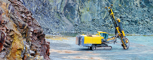
Trimble has introduced the DPS900 Piling System, a dedicated land-based 3D machine control system for a variety of piling machine makes and models. The accuracy of the system allows piling contractors to increase operational efficiency and reduce costs for building structural foundations, retaining walls, coffer dams, and solar or wind farm installations.
“The DPS900 Piling System can transform the way piling contractors work,” said Alan Sharp, business area director for Trimble Heavy Civil Construction. “Without DPS900, the process is manual and often error prone. With the DPS900 system, contractors can take advantage of accurate positioning and automated reporting to ensure machines are being utilized efficiently.”
The DPS900 Piling System reduces surveying costs associated with staking and as-built checks. In addition, the system can increase on-site safety by reducing the number of people around machines, pilings and foundations. Accurate positioning in DPS900 can ensure navigation time between piles is reduced, resulting in increased piling time to maximize production and revenue per day.
Built-in, automated quality assurance and quality control reporting includes capture of start and end positions, time and elevation, as well as actual embedment depth, blow count reporting, and inclination and orientation control. In addition, unique system logins allow managers to filter reports by operator for better accountability, production optimization and forecasting.
Business Center–HCE office software by Trimble is used to create pile plans in the office, and allows for integration with data prep, estimating and reporting functions. Piling machines can be connected to the office using Trimble Connected Site solutions for wireless data transfer and GNSS corrections. In addition, machines can be tracked and monitored using VisionLink for location, hours and utilization information.
The new Trimble DPS900 Piling System is available now in Australia, Europe, North America, Chile and South Africa through Trimble’s SITECH Technology Dealer Channel.
The growth of precision farming market is expected to be remarkable, and is estimated to reach $3.7 billion by 2018, at an estimated CAGR of 13.36% to 2018, according to a report by ReportsnReports. The global population is expected to rise up to nearly 7.5 billion by the year 2020, and the ability to manage and tackle the ever-increasing demand for food will in all likelihood continue, the report says.
Climate Change. Global warming continues to be an influential deciding factor in determining agriculture productivity, as well as soil properties and sustainability of natural resources. The effect of climate change on agriculture is related to variability in local climates rather than global climate patterns. All these concerns marked the way for the entry of the new world of agriculture management practices, the report says. Precision farming can significantly reduce the amount of nutrient and other crop inputs used while boosting yields. Farmers, thus, obtain a return on their investment by saving on phytosanitory and fertilizer costs. The second large-scale benefit of targeting inputs in spatial, temporal and qualitative terms reduce concerns of environmental impacts, the report says.
The major drivers for this market are augmented yield and profitability, which are the major contributing factors for farmers to go for precision farming; other drivers like energy and cost saving and government assistance have also been contributing to the market growth. Major restraints such as high initial investments, and lack of awareness and their impact analysis, are also covered under this study. North America leads the market share for precision farming as this region has the maximum adoption. The Asia-Pacific region (APAC) is the emerging market for precision framing and has been enjoying the highest growth rate among all the geographic regions. It is believed that the APAC market will grow at a CAGR of 25.16% from 2013 to 2018.
The report covers all the technologies, components, and applications of precision farming; it provides a detailed analysis of the current market scenario and estimation for the next five years. Major applications like field mapping and yield monitoring are driving the market. Moreover, the market is driven by some of the most important technologies like GPS and variable rate technologies. This market is already progressing well in developed countries, and it is also expected to grow well in developing nations as a result of their ever-growing food demands.
Companies like Ag Business & Crop Inc., Ag Leader Technology, Ag-Nav Inc., Agco Corporation, Agjunction Inc., Agri Con Gmbh, American Sensor Technologies Inc., Autofarm, Automata Inc., Deere & Company, Dickey-John Corporation, Echelon Ag Inc., Jain Irrigation Systems Ltd., Omnistar, Planting Inc., Precisionagriculture.Com.Au, Raven Industries Inc., Soyl Precision Farming, Teejet Technologies, The Toro Company, Topcon Precision Agriculture & Trimble Navigation Limited are profiled in this research available for purchase.
This report profiles companies which are major players, and are active in this market. The report presents the ‘competitive landscape of the players’ that covers key growth strategies followed by all the major players.
Attracting more than 400 precision ag experts from 40 countries, the 12th International Conference on Precision Agriculture will be held July 20-23 at the Hyatt Regency in Sacramento, California, USA.
In the heart of high-value agriculture, the Sacramento setting is fitting to the high-tech talks on the program. The global scale of the conference is apparent from the list of presenters and exhibitors. ICPA brings together a unique mix of researchers, industry, and practitioners.
ICPA is the premier scientific conference on precision agriculture. “We selected the top research papers from around the world for the conference. With session chairs in precision water management, precision horticulture, unmanned aerial vehicles, precision conservation, precision livestock, remote sensing, and data standards, the oral program reflects the diversity of our members’ interests,” said Dr. John Stafford, President of ISPA. In addition, the program features two poster sessions with over 70 posters on display during the conference.
The program also features talks on practical applications of the latest technology in crop and livestock production. Through the support of our major sponsors, the conference will feature a track for practitioners in addition to the five tracks on precision ag research. “At ICPA we have continued to appeal to the practitioner in addition to the researcher and academic. It is important that the research work finds its way into practical applications in crop production,” said Quentin Rund, Conference Secretary.
The schedule provides plenty of time for interaction among attendees. From the Sunday night welcome reception sponsored by E & J Gallo Wineries, to the dedicated time for exhibits and posters during breaks and evening receptions, the program promotes networking and opportunities for in-depth discussion among attendees, presenters, exhibitors, and sponsors.
For international and domestic visitors to the area the conference has partnered with the University of California-Davis to organize a post-conference tour for Wednesday afternoon after the closing session. The tour will feature area stops on UAVs, high-tech tomato production, precision irrigation, and imaging systems in wine grape production. Other options for exploring the area are available, too.
The conference is organized by the International Society of Precision Agriculture. More information is available online at www.ispag.org/icpa including program, exhibits, tours, and accommodations. Online registration is open
The conference is sponsored by E & J Gallo Wineries, Monsanto, DupontPioneer, and Springer.
Hexagon AB, a global provider of design, measurement and visualization technologies, has acquired iLab Sistemas, a provider of planning and optimization solutions for the agro business sector, with special focus in the sugar and ethanol industries. iLab will, together with Arvus and Leica Agriculture, form the backbone of Hexagon’s Smart Agriculture Solution.
Headquartered in Ribeirão Preto, Brazil, iLab takes advantage of extensive know-how and various techniques to deploy highly parameterized solutions that address complex problems related to agricultural processes and production. They include linear programming, operations research, genetic algorithms, constraint-based programming, neural networks, statistics and advanced mathematics. ILab’s offerings include software optimization tools for every stage of crop growth — from planting, harvesting and logistics planning to area and asset management, scenario comparisons, and cost and budget forecasting — permitting value-added decision analysis and process automation.
“Together with its established software suite of end-to-end planning optimization solutions for sugarcane mills, iLab’s strong market footprint in the sugarcane industry will support the further development of the Smart Agriculture solution from Hexagon Solutions,” said Hexagon President and CEO Ola Rollén. “Additionally, iLab’s offerings complement the product portfolios of Hexagon brands Leica Geosystems, Sisgraph and Devex in areas such as fleet management, precision agriculture, automation platforms and control room technologies.”
ILab will be fully consolidated as of today. The acquisition has no significant impact on Hexagon’s earnings, Hexagon AB said.
Geoforce, Inc., an international provider of asset management solutions for the oil and gas industry, has announced the widespread commercial availability of the GT0, a tiny industrial GPS asset-tracking device. The device is designed to track and remotely monitor assets too challenging for other GPS devices, the company said.
“Geoforce is constantly trying to gauge what our customers will need next,” said James MacLean III, Geoforce’s president and CEO. “What we’ve been hearing out there is this: smaller, easier and whenever possible — more affordable. We’ve purpose-built this device to try and meet those needs without dropping the quality-level our customers deserve.”
The GT0 has a powerful omni-directional antenna, allowing for placement in almost any orientation on an asset. The tracking device is engineered with RFID and GPS technology for location and identification, as well as QR coding for mobile scanning of product information. Its compact size allows the tag to fit on equipment where previous larger and bulkier asset-tracking devices could not be implemented. It is an IP67 device (weatherproof) and has an optional metal bezel for added protection. It has an expected five to seven year battery life, making it a simple-to-deploy “slap and track” device.
More than 300 companies currently use Geoforce’s solutions to manage 100,000 assets across six continents. The GT0 was previously offered in limited release to several service and rental companies beginning in January of this year.
On April 1, Rohde & Schwarz joined the M2M Alliance, the largest association for the machine-to-machine sector.
“The advanced networking between people and machines and among machines themselves is completely changing our lives. It is opening up entirely new fields of application for our wireless test solutions,” said Jörg Köpp, who is responsible for the M2M/NFC market segment at Rohde & Schwarz. “With our commitment to the M2M Alliance, we want to promote this future-oriented technology worldwide.”
“We are very pleased to welcome Rohde & Schwarz to the M2M Alliance and gain a wireless specialist that has stood for quality and innovation in wireless communications technology for 80 years,” said Eric Schneider, first chairman of the M2M Alliance. “The company’s wireless test solution expertise and comprehensive portfolio make it an asset to the entire M2M industry.”
The reliability and security of mobile and wireless technologies are crucial to the success and acceptance of M2M applications. There are many industries where wireless applications have not previously played a role, but now even household appliance manufacturers, for example, are facing the challenge of integrating wireless components into their products. They need to verify that these components function correctly and obtain any necessary certification.
Rohde & Schwarz supports these users by providing T&M equipment for almost all mobile, wireless and positioning technologies, from LTE/LTE-Advanced, UMTS/HSPA(+), CDMA2000, Bluetooth and WLAN wireless Internet access to GPS/Galileo. Rohde & Schwarz also offers specific test solutions for eCall and vehicle-to-vehicle communications. Solutions for secure M2M communications and monitoring of associated networks round out the portfolio.
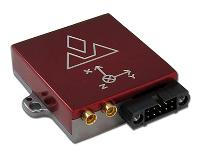
VectorNav Technologies has introduced its VN-300 dual-antenna GPS-aided inertial navigation system (GPS/INS). A follow-on product to the VN-100 IMU/AHRS and VN-200 GPS/INS, the miniature, high-performance VN-300 enables a wider range of applications through the incorporation of GPS compassing techniques.
The VN-300 can be used in a wide variety of industrial and military applications, and is well suited for size, weight, power, and cost (SWAP-C)-constrained applications such as unmanned vehicle systems; antenna, camera and platform stabilization; heavy machinery monitoring; robotics; and primary or secondary flight navigation, among others. The VN-300 will be on display and available for review at VectorNav’s booth #330 at AUVSI in Orlando May 13-15.
Incorporating the latest MEMS sensor technology, the VN-300 combines 3-axis accelerometers, 3-axis gyros, 3-axis magnetometers, a barometric pressure sensor, two GPS receivers, and a low-power microprocessor into a rugged aluminum enclosure about the size of a matchbox. When in motion, the VN-300 couples the position and velocity measurements from the onboard GPS receivers with measurements from the onboard inertial sensors to provide position, velocity, and attitude estimates of higher accuracies and with better dynamic performance than a standalone GPS receiver or Attitude Heading Reference System (AHRS).
The dual GPS receivers incorporated into the VN-300 provide the added benefit of accurate True North heading measurements when the sensor is stationary through the use of GPS compassing techniques, the company said. The VN-300 is designed for applications that require a highly accurate inertial navigation solution under both static and dynamic operating conditions, especially in environments with unreliable magnetic heading and good GPS visibility.
VN-300 Differentiating Features:
The VN-300 has small size, low weight, and low power requirements.
With Development Kits priced around $5k USD, the VN-300 is a fraction of the cost of similarly performing dual-antenna GPS/INS systems and is competitively priced with other MEMS-based GPS/INS systems that do not provide the dual-antenna moving baseline RTK features.
The GPS compass feature coupled with the GPS/INS capabilities on the VN-300 enables applications that require high-accuracy position, velocity, and attitude measurements under both static and dynamic operating conditions.
The algorithms on board the VN-300 enable applications to seamlessly transition between static and dynamic operations without having to collect extended stationary measurements or perform specific dynamic maneuvers in flight for attitude alignment.
The VN-300 incorporates a “True INS Filter” that does not force any requirements on alignment of the sensor to the velocity direction of a platform or specify the orientation of the sensor for initial alignment.
“The VN-300 is unique in that it provides a complete, high performance GPS-aided navigation solution under both stationary and moving conditions, all in a miniature and cost-effective package,” said VectorNav President, John Brashear. “By addressing some of the most difficult issues users face when trying to integrate an inertial navigation system — high cost; large size, weight and power; unreliable magnetic environments; and restrictive operating requirements — the VN-300 will enable an unprecedented number of applications.”
Raven Industries, Inc. announces that its Applied Technology Division (ATD) has acquired SBG Innovatie BV and its affiliate, Navtronics BVBA. Headquartered in Middenmeer, Netherlands, SBG manufactures advanced GPS steering systems for a variety of agricultural applications. The acquisition broadens Raven’s guided steering system product line by adding high-accuracy implement steering applications. Additionally, SBG’s headquarters will become the new home office for Raven in Europe, expanding the company’s global presence and reach into key European markets. The purchase is not expected to have a material impact on Raven’s fiscal 2015 results.
“SBG specializes in very precise, real time kinematic, or RTK, GPS steering systems with a focus on high-value crops. Their highly accurate implement steering technology broadens Raven’s existing product line and integrates well into the Raven product portfolio.” said Matt Burkhart, ATD’s Division Vice President and General Manager. “We are proud to welcome the SBG organization into the Raven family. Our innovative cultures align very well, and SBG’s leading technology and strong team members will be a great compliment to further Raven’s position as a leader in the precision ag market.”
“Our priorities within ATD are to drive growth through international market expansion, new products and broadening OEM relationships,” said Daniel A. Rykhus, Raven’s president and chief executive officer. “We believe SBG can help further these strategies and position us for success in new markets.”
“We’re excited to join Raven so that, together, we can expand Raven’s footprint in key geographies and augment their expertise and product line,” said Rik van Bruggen, managing director of SBG. “In turn, Raven’s scale and resources will allow SBG to realize our dream of growing the business and helping customers increase yields and efficiencies. Raven is a good partner for us because they are committed to increasing their presence in Europe and providing additional opportunities for our team.”
Effective immediately, SBG’s products will be offered as a part of Raven’s lineup of precision ag products. Sales team members from both companies will be offering the combined product lines.
Trimble is making available the Trimble Irrigate-IQ precision irrigation solution in North America. Along with the North American launch, Trimble also introduced the Connected Farm Irrigate app, which provides farmers with real-time status and control of their pivot irrigation systems using a smartphone or tablet.
The Irrigate-IQ GPS-controlled solution, which is installed on the pivot, enables farmers to remotely control their irrigators via the Internet, including performing variable rate irrigation, and receive reports about where water or fertilizer has been applied. With the solution, farmers can apply the optimal amount of water, fertigation or effluent where needed, which can improve crop quality and yield, while minimizing nutrient and chemical runoff. The solution enables farmers to conserve water use and improve efficiency, reduce energy costs for fuel and electricity, minimize input costs, comply with environmental regulations, and safely dispose of effluent. In addition, Trimble’s brand-agnostic strategy allows farmers to use the solution with most irrigator makes and models. Irrigate-IQ is also available in New Zealand.
In addition, Trimble introduced the Connected Farm Irrigate app for use on an iPhone, iPad, Android smartphone or tablet. The app allows farmers to see the status of their pivots, including whether they are operating or not operating, in which direction they are traveling, the heading, pump pressure, pivot voltage and type of material being dispersed (water, fertigation, or effluent). It also gives farmers the ability to remotely start or stop their pivots, choose the direction (forward or reverse), turn the pump on or off or switch the type of material being dispersed. This new functionality comes in addition to farmers’ ability to remotely control their irrigators by accessing the Irrigate-IQ software on a desktop or laptop computer, rugged mobile computer or tablet.
“Now that Trimble has expanded availability of its Irrigate-IQ solution, and launched the Connected Farm Irrigate app, farmers across North America and New Zealand will be able to monitor and control their irrigators from virtually any location,” said David Fitzpatrick, business area director of Trimble’s Agriculture Division. “Irrigate-IQ allows farmers to be more strategic with their irrigation planning, while the app creates time savings and increased efficiencies by allowing farmers to respond to weather changes or faulty equipment on the fly without being on site.”
The Irrigate-IQ solution and Connected Farm Irrigate app are both part of Trimble’s Connected Farm solution, which includes a robust suite of recently announced features including soil analysis, rainfall totals, weather forecasts, commodity tracking, and now irrigation monitoring and control.
Trimblehas released a new GNSS-based machine control solution to improve efficiency of bulk earthworks and landfill compaction operations. Installed on a four-drum soil or landfill compactor, the Trimble CCS900 Compaction Control System allows a machine operator to make more uniform and efficient passes, report compaction production data in the field, and ensure target compaction is reached with minimal fuel usage and machine wear.
The announcement was made at WasteExpo 2014, North America’s largest solid waste and recycling tradeshow.
CCS900 for Bulk Earthworks. The CCS900 system tracks compaction passes in real time with easy-to-read color mapping on the in-cab display. It improves bulk earthworks operations by ensuring fill material is adequately balanced and uniformly compacted from the bottom up.
CCS900 for Landfills. Landfill operations require contractors to compact the maximum amount of waste into the smallest area of vertical and horizontal cell space. Using CCS900, landfill owners can ensure that cell space is optimized, voids are eliminated and layers are compacted to their target density more efficiently. With real-time mapping on the in-cab display, the operator can avoid unnecessary passes that waste fuel and cause additional wear on the machine. The system also collects as-built layer information for in-field reporting and tracking of daily volumes.
In-Field Reporting and Printing for Quality Control. For both soil and landfill applications, Trimble CCS900 offers extensive in-field reporting options, including in-cab report generation and printing. This functionality allows compaction production analysis to be carried out in the field instead of waiting until data is transferred back to the office. Compaction progress and problem areas are indicated on the in-cab graphical control box and listed in the in-field report so they can be addressed immediately, instead of at project completion when re-work is more costly. An optional serial printer in the compactor cab also enables supervisors to sign off on the completion of the compaction work in the field.
Calling it an “unprecedented and deeply worrying total disruption . . . [that] shook the industry,” Locata Corporation reiterated its call for redundant terrestrial systems to back up GNSS in the wake of the April 1 11-hour GLONASS system outage.
Nunzio Gambale, Locata CEO, said “We have been telling the industry for years that you cannot have a critically important capability like GPS without also having a backup! What is Plan B if the satellite systems fail? What replaces the space signal when there is a problem? If anyone needed a sign to understand why Locata has spent years inventing and developing the world’s first local terrestrial equivalent of the GPS system, then last week’s meltdown of a complete global satellite navigation system is it. This event should terrify every nation, government, and company that depends on navigation satellites for their business or, in some cases, their very lives.”
The navigation and timing functions of the global positioning systems underpin the world’s banking systems, stock exchanges, digital TV and Internet, cell phone networks, and, in some cases, the national electricity supply, Locata pointed out. GPS, in particular, plays a crucial role in transportation, shipping, and logistics, serving as the enabling technology for critical functions like air traffic control. Reliability is therefore not just important; it is essential across all applications. Locata, the Resilient Navigation and Timing Foundation (RNTF) in Washington, D.C., and others have persistently called attention to the need for redundant terrestrial systems that will back up expensive, vulnerable, and aging global satellite navigation constellations while simultaneously providing the local control and resiliency that satellite-based systems cannot deliver.
Professor Chris Rizos of the School of Civil and Environmental Engineering at the University of New South Wales stated that “This catastrophic failure of one of the world’s two global satellite navigation constellations is a wakeup call for all of us. We ignore the possibility of these ‘Black Swan’ events at our own peril.”
The GLONASS disruption was felt around the world, immediately upon its origination, especially in professional applications, such as tractor automation for farming, machine control and robotics in mining and heavy industry, and in the national infrastructure used by surveyors and industry across many countries.
“This shows just how interlinked the physical and cyber worlds have now become,” added Professor Brett Biddington, a space and cybersecurity expert from the School of Computer and Security Science at Edith Cowan University, Australia. “The prospect of a software glitch, whether unintentional or intentional, seems highly likely [as a cause for the failure]. If it was a deliberate attack, however, it points to a changing face of warfare where the real enemy may be impossible to detect and deter until very damaging strikes, such as an attack on the GPS system, have already taken place.
“The vital point here is that this is no longer just a question for scientists and technologists. A locally controlled backup system for this essential signal is a national policy question of the highest order.”
Locata Corporation and other industry authorities have long testified on global satellite navigation vulnerabilities and the need for diverse technology options to strengthen and back up GPS, GLONASS, and other systems. Locata developed a robust solution and has been awarded a sole-source contract by the U.S. Air Force (USAF) to provide its terrestrially based alternative positioning for military applications where GPS has been completely jammed. The first wide-area Locata system is being deployed now at the White Sands Missile Range in New Mexico. The USAF demonstrated that the White Sands Locata network delivers what has been extremely high accuracy over a 2,500-square mile area, positioning aircraft flying up to 35 miles away to an accuracy of better than six inches.
A pair of LocataLite transmit antennas overlook a section of the White Sands Missile Range blanketed by the Locata high-precision ground-based positioning system.
“There is no other technology that can do this, and it’s delivered in the complete absence of GPS,” continued Gambale. “What is being demonstrated at White Sands is that Locata supplies precisely the same function as GPS, even when there is no GPS available. That’s exactly what you need if the satellites fail.
“If this event had been a GPS failure instead of a GLONASS failure – and it could very easily have been – then the entire world would have plunged into a catastrophe. This event is the navigation equivalent of a ‘close call moment,’ and from here on out no one can even question that this is a really serious problem that must be addressed. Another industry expert recently told me, ‘If there was a sustained GPS outage, it would cause a global financial nuclear winter from which it would take us decades to recover.’”
Gambale concluded, “We need action to develop local backups like Locata around places like airports and other strategically important areas – now! We must not wait until we are faced with another seemingly impossible event like a complete satellite constellation failure. We may not dodge this bullet a second time.”
Locata terrestrial positioning technologies complement GPS by setting up ground-based transmitters, called LocataLites, to create a local constellation called a LocataNet. Once properly deployed, Locata’s unique nanosecond-accurate TimeLoc system synchronizes the network, which allows it to replicate the positioning capabilities of GPS, locally. LocataNets operate today in environments ranging from small warehouses to open-cut mines, wide-area aircraft approach-and-landing systems, and wider areas for aircraft and unmanned aerial vehicle (UAV) uses.