Hemisphere GNSS has announced that all professional-level Vector products — including the V103, V113, VS131, and VS330 — now include the ability to utilize the GLONASS system along with GPS in the navigation solution. The tracking of the additional GLONASS signals provides a more robust solution, especially in challenging environments, the company said.
Vector Technology processes L1 GPS and GLONASS signals to deliver precise heading, greater positioning reliability, and improved performance in challenging environments. Hemisphere GNSS’ patented Vector technology computes the heading and pitch or roll angle while stationary or in motion allowing for heading accuracy of up to 0.01 degrees depending upon the product selected. A variety of differential correction methods also make it possible for Vector products to provide sub-meter to centimeter level RTK position accuracy.
Professional marine industry organizations can maximize performance by integrating Hemisphere GNSS Professional Vector technology into their systems for hydrographic and bathymetric surveys, autopilots, dredging, and buoys. For land applications, Vector Technology is designed for the alignment of cameras, antennas, and projectiles, and for machine control applications in agriculture, construction, and mining.
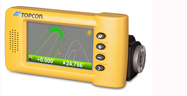
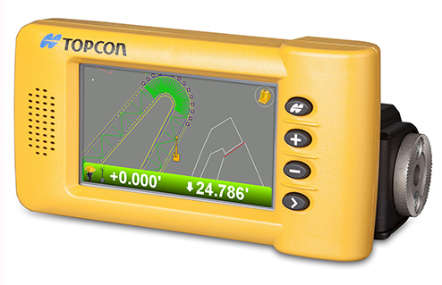
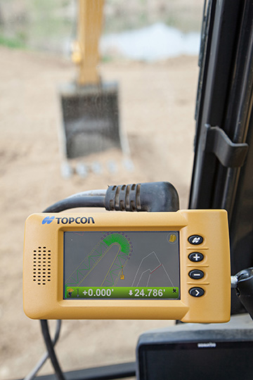
Topcon Positioning Group announces the addition of two new indicate control systems to its excavator control system lineup — the X-32 and X-33. The systems feature Topcon’s new GX-30 control box and TS-i3 sensors.
The GX-30 features a full-color touchscreen display. The TS-i3 sensors have no moving components, offer single and dual-axis measurement modes, and include convenient LED status indicators.
“The X-32 is a versatile and easy-to-use 2D excavator system that includes technology not available on other, more expensive systems,” said Kris Maas, manager for machine control product marketing.
“The X-32 is an excavator grade indication system to fit any budget. With this new system, you have the flexibility to use a wide array of references from which to work: Existing surface, a hub, previous cut, single slopes and dual slopes with the use of a compass or rotating laser. It’s as easy as choosing your reference and entering a cut and/or slope depth,” Maas said.
“The X-32 allows an operator to work faster, with consistency and greater degree of accuracy, and promotes a safer work site by keeping a grade checker out of the trench.”
Additionally, Maas said, “The X-32 grows as your needs expand because it’s easily upgradeable to a 3D system.”
“The X-33 adds Topcon’s industry-leading GNSS satellite technology to create a highly productive 3D indicate excavator grade control system,” Maas said. The system’s MC-i3 GNSS receiver with Vanguard technology provides “maximum flexibility in satellite signal tracking. Additionally, the MC-i3 is Sitelink3D ‘ready’ for integration into Topcon’s real-time 3D management solution,” he said.
The new 3D system is designed to establish grade faster and ensure the operator stays on grade. “The system eliminates over excavation and controls material usage, allowing the user to ‘see’ the exact position of the machine on site and the bucket position at all times,” Maas said. When detailed information is required, the operator can select to visualize the plan, profile, or sectional view and use the dual grade indicators for elevation control.
Hemisphere GNSS, Inc. today announced that Chuck Joseph has been named president and chief executive officer, effective immediately, replacing Phil Gabriel. Joseph has also been appointed to the Hemisphere GNSS Board of Directors.
Joseph has more than 30 years of executive leadership across multiple industries, serving in corporate officer and board of director capacities. He has extensive proven experience in GNSS OEM and direct sales market segments including survey and mapping, GIS, machine control, marine, avionics, personal (mobile) navigation, and tracking systems.
Before joining Hemisphere GNSS, Joseph most recently served as president and chief operating officer of nusola, Inc., an energy technology company he co-founded and where he continues to serve as executive chairman of the Board. Previously, among other roles, Joseph was senior vice president and general manager of Immersion Corporation, a tactile feedback technology company focused on GPS-centric mobile and industrial applications, corporate vice president of marketing and sales for Magellan Corporation, and executive vice president and general manager of Trimble Navigation.
“Chuck is a proven executive with the experience and expertise to lead Hemisphere GNSS as we enter our next phase of growth and development,” said Jonathan Ladd, chairman of the Hemisphere GNSS Board of Directors. “Over the course of his career, Chuck has repeatedly demonstrated the ability to develop critical corporate strategies to help innovative companies scale and grow globally. His understanding of our business, significant international experience, and deep OEM and GNSS industry experience make him ideally suited to lead Hemisphere as we seek to accelerate company growth.”
“Hemisphere has long been recognized for its pioneering and trend setting high-precision GNSS technology, and I look forward to leading the company’s talented team as we make the strategic decisions necessary to expand our market share and OEM presence globally,” Joseph said. “Leveraging our deep GNSS experience and strong, core GNSS technologies, along with UniStrong’s high quality, low-cost product design and development resources, Hemisphere is poised for significant global growth.”
In conjunction with the reported change in management, Hemisphere GNSS is also announcing the departure of Phil Gabriel, the company’s previous president, effective today. Ladd commented, “Phil was instrumental in getting our company off the ground after the acquisition from AgJunction Inc. in early 2013. We thank Phil for his contributions and dedication during the past year, and wish him good fortune and success on his next endeavor.”
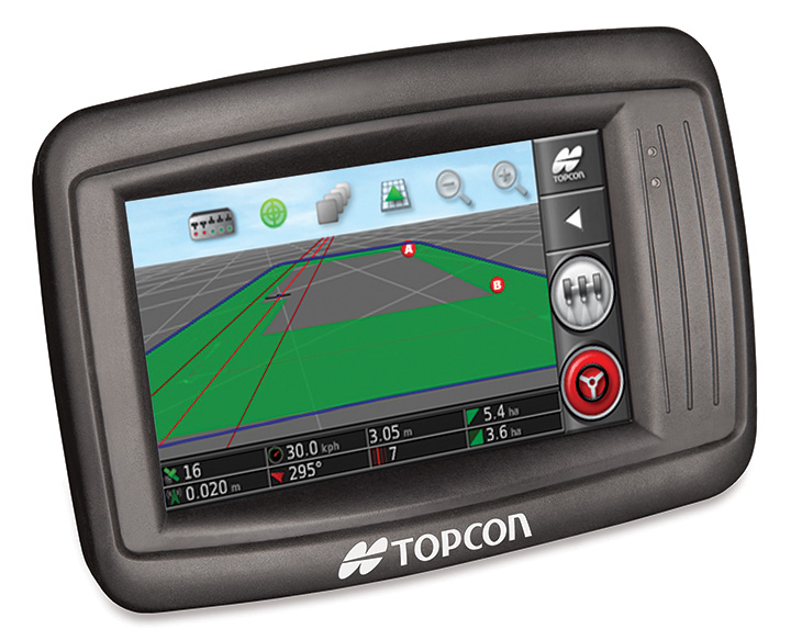
Topcon’s X14 touchscreen display for precision agriculture.
Topcon Precision Agriculture is introducing a new 3D color touchscreen display, the X14. The precision farming in-cab display offers entry-level guidance with the look and feel of TPA’s larger, easy-to-use X30 touchscreen console, the company said.
The 10.9-cm (4.3-inch) full-color 3D touchscreen offers moving map visualization and an on-screen, software-based virtual lightbar. For low-cost guidance, the X14 can be paired with Topcon’s SGR-1 GNSS receiver featuring TruPass technology.
For high-accuracy autosteering, the X14 can be paired with Topcon’s new AGI-4 GNSS receiver/steering controller, which provides autosteering performance and modular upgradeability to add high-accuracy inertial sensors or RTK correction communication.
“The X14 offers a simple, icon-based, user-definable interface with a full range of guidance patterns including boundary and U-turn recognition,” said Kevin Cobb, TPA director of product management. “The bright, sunlight readable display offers easy setup on leading market vehicles, and is an outstanding addition to our growing line of innovative, easy-to-use, full-featured color touchscreen consoles.”
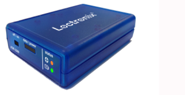
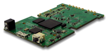
Loctronix Corporation, a provider of unified positioning solutions for GNSS-challenged environments, announced that it has begun shipments of its new software-defined radio (SDR) module, the ASR-2300, for developing high-performance positioning, navigation and timing (PNT), and communication applications.
“The ASR-2300 delivers advanced SDR capabilities in a small, mobile form-factor enabling developers to readily create and field complex SDR-based solutions. Featuring a 2×2 multiple-input, multiple-output (MIMO) RF transceiver and an array of inertial sensors, the open-source ASR-2300 is an ideal platform for tapping advanced, multi-sensor/signals of opportunity for high-performance PNT,” said Michael Mathews, Loctronix’ CEO and founder.
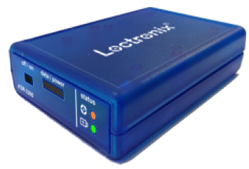
Loctronix ASR-2300 kit.
“Unique amongst the growing number of SDRs, Loctronix’ ASR-2300 provides multiple, fully-integrated RF paths supporting reception of GNSS, cellular, ISM band, and UHF signals of opportunity, making it well-suited for demanding scientific, military, aerospace and commercial/industrial applications, such as UAV/UAS navigation, GPS-challenged or -denied tracking and navigation, combined communications and navigation radios, and GPS integrity monitoring and validation,” Mathews noted.
The MIMO transceiver module incorporates two wideband Field Programmable RF (FPRF) transceivers (300 MHz to 3.8 GHz), 10-axis accelerometer/gyro/compass/barometer sensors, and a large programmable FPGA capable of over 300 MiB/sec sustained communications with a host processor via USB 3.0 interface. The module’s nine integrated RF path options and low size, weight, and power characteristics contribute to ease of integration and portability, Loctronix said. Accommodating both internal 1 PPM TCXO or external frequency reference, multiple ASR-2300s can be inter-connected via an expansion port and/or UART interface, supporting real-time reception / transmission of 4, 6, 8 or more signals without the need for significant additional hardware.
Developers looking to create solutions for demanding military, scientific and industrial applications will realize greater functionality with the ASR-2300, thanks to its multiple sensor and multiple frequency capabilities, Loctronix said. Additionally, access to a variety of user-friendly development tools facilitates waveform experimentation and helps speed the creation of these new solutions, resulting in shorter development times and lower development costs for high-performance PNT applications.
Bundled kits, which include the module, housing, and power/data communications/RF interfaces, are priced at $1,600 with a special educational discount available for qualified institutions. The ASR-2300 SDR is available directly from Loctronix.
Trimble has announced a new feature for its RainWave precipitation monitoring solution for agriculture. As part of the Connected Farm solution, the new feature adds actual rainfall activity in 10-minute increments plus accumulated rainfall over a 24-hour period. With this comprehensive rainfall information, farmers can have a better understanding of the rainfall intensity, which can be used to make more informed decisions for irrigation and other farming operations.
For example, if RainWave information shows that a large amount of rain fell in a short period of time, much of that rainfall may have run off the field and be unavailable to the crop. In contrast, if the information shows a slow steady rain, farmers may assume that the rainfall has a better chance of being absorbed in the soil and can be available to the crop.
“With RainWave’s added functionality, Trimble is placing another valuable piece of information in farmers’ hands,” said David Fitzpatrick, business area director for Trimble’s Agriculture Division. “By providing a better understanding of how rainfall may have impacted soil moisture levels, farmers can optimize their irrigation planning, fleet management and timing of materials application for nutrient and pest management.”
The RainWave solution enables farmers across the U.S. to set up virtual rain gauges by entering GPS coordinates for identified locations in order to receive a rainfall report for those locations. Since on-site rain gauges are not needed, farmers no longer need to monitor dispersed gauges or manually track precipitation. Farmers are able to obtain the RainWave information through their Connected Farm dashboard, a Web portal that provides one centralized location for farmers to view key information impacting their operations.
Today, Hemisphere GNSS introduces the Eclipse P306 and P307, the latest models in the Eclipse series. The Eclipse P306 and P307 track multi-frequency GPS, GLONASS, and BeiDou satellite signals and are Galileo and QZSS ready. By tracking more signals, RTK positioning performance improves especially in challenging environments.
The Eclipse P306 and P307 are the first products to utilize the company’s new SX4 ASIC. Capable of simultaneously tracking code and phase signals on 89 satellites, SX4 boasts 372 channels and can be configured to address several diverse applications through software.
Smaller than a business card, the Eclipse P306 upgrades existing designs using Hemisphere’s standard 34-pin modules. The Eclipse P307 is a drop-in upgrade for designs based on the industry accepted 20-pin module. Both products offer scalable performance. RTK accuracy is achieved in either single- or dual-frequency mode. When subscribed for multi-frequency, multi-constellation RTK, Eclipse receivers have fast RTK initialization times even over long distances.
“While the Eclipse P306 and P307 provide outstanding RTK performance,” commented Dr. Mike Whitehead, Chief Technology Officer of Hemisphere GNSS, “non-RTK users benefit from our COAST, SureTrack, and HeadStart technologies.” COAST and SureTrack work together to maintain sub-meter positioning for 40 minutes when differential corrections are lost. HeadStart reduces the occurrence of cold starts by keeping time while the receiver module is powered off, providing faster startup times.
Support of the Chinese BeiDou GNSS constellation is significant. The BeiDou constellation not only fully covers China, but extends beyond, covering 2/3 of the world’s land mass, benefiting 5.8 billion people. Coverage currently includes Asia, Australia, New Zealand to South Africa, Europe and all of Russia, as well as Hawaii with, on average, three or more BeiDou satellites visible above 15°.
In February 2013, Hemisphere GPS changed its name to Hemisphere GNSS, Inc., after parting ways with its agriculture unit. While both names are owned by the company, in order to reflect the company’s support of all GNSSs and update the company’s image, “Hemisphere” has been adopted as its brand name. The company also has adopted a new logo and has launched an updated website, www.HemisphereGNSS.com.
Hemisphere will be introducing the new Eclipse P306 and P307 OEM positioning modules at the annual Intergeo conference in Essen, Germany, October 8th-10th, 2013 at Booth #A3.070.
Research and Markets has issued a new precision farming technology report. According to the report, the growth of the market is expected to be remarkable, and is estimated to reach $3.72 million by 2018, at an estimated CAGR of 13.36% from 2013 to 2018. The major players in this industry are Deere & Co. (U.S.), Trimble Navigation (U.S.), Topcon positioning systems (U.S.), Raven Industries (U.S.), Precision Planting (U.S.), and AGCO (U.S.).
The major drivers for this market are augmented yield and profitability, energy and cost saving, and government assistance. Major restraints such as high initial investments and lack of awareness and their impact analysis are also covered under this study. North America currently leads the market share for precision farming as this region has the maximum adoption. Asia-Pacific (APAC) is the emerging market for precision framing and has been enjoying the highest growth rate among all the geographic regions. It is believed that the APAC market will grow at a CAGR of 25.16% from 2013 to 2018.
The full title is “Precision Farming Market by Technology (GPS/GNSS, GIS, Remote Sensing & VRT), Components (Automation & Control, Sensors, FMS), Applications (Yield Monitoring, VRA, Mapping, Soil Monitoring, Scouting) – Global Forecast & Analysis (2013 – 2018).”
The report covers all the technologies, components, and applications of precision farming; it provides a detailed analysis of the current market scenario and estimation for the next five years. Major applications like field mapping and yield monitoring are driving the market. Moreover, the market is driven by important technologies like GPS and variable rate technologies. This market is already progressing well in developed countries and it is also expected to grow well in the developing nations as a result of their ever growing food demands.
This study describes the value chain for precision framing market by considering all the major stakeholders in the market, and their role analysis. The report also performs a detailed scrutiny of the Porter’s five force analysis for the market. All the five major factors in these markets have been quantified using the internal key parameters governing each of them.
Key Topics Covered:
1 Introduction
2 Executive Summary
3 Cover Story
4 Market Overview
5 Global Precision Farming Market By Technology
6 Global Precision Farming Market By Hardware & Software Components
7 Precision Farming Market by Application
8 Global Precision Farming Market By Geography
9 Competitive Landscape
10 Company Profile – Overview, Products And Services, Financials, Strategy & Development
PCTEL, Inc. announced the launch of its next generation multi-band GNSS antennas for global timing and precision tracking applications at the ION GNSS Conference being held this week in Nashville, Tennessee.
The new antennas, which are designed for use with GPS, GLONASS, BeiDou, and Galileo systems, are being showcased along with other PCTEL antennas at the PCTEL booth in the Exhibit Hall, Booth 318/320. All models of the new antennas are available for sale.
Equipment providers for carrier network timing, precision agriculture, and global asset tracking applications need a single antenna solution for global deployment. PCTEL’s new GNSS1-TMG-26N and GPS-LB12GL-MAG antennas address global compatibility issues for two of the industry’s most crucial applications.
For critical timing applications for macro and small cell deployments, PCTEL has developed the GNSS1-TMG-26N antenna. The GNSS1-TMG-26N is a fixed mount network timing antenna covering GPS, GLONASS, Beidou, and Galileo system frequencies in one single unit, making it a true global solution.
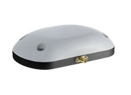
PCTEL’s GPS-LB12GL-MAG antenna is designed for precision agriculture.
For global precision navigation applications, PCTEL has developed the GPS-LB12GL-MAG to cover GPS L1, GPS L2, GLONASS, and L-BAND constellations. The GPS-LB12GL-MAG’s multi-band coverage addresses the precision market in the USA as well as differential correction signals needed across Europe and Asia.
“PCTEL will meet the GNSS market requirements for our global customers while maintaining PCTEL’s high standards for quality and performance,” said Jeff Miller, president of PCTEL Connected Solutions. “We understand that our products need global compatibility to support our customers around the world. We are proud to showcase our design excellence in this highly technical area,” added Miller.
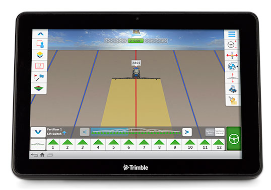
Trimble has launched the Connected Farm dashboard, which provides one centralized location for farmers to view key information impacting their operations. With this information, farmers will be able to make better daily decisions based on the latest data. The Connected Farm dashboard is customizable and accessible via Internet-enabled devices such as desktop and notebook personal computers, smartphones and tablets, and Trimble’s new TMX-2050 display.
Trimble TMX-2050 display.
The TMX-2050 display is a next-generation display built on the Android operating system. It offers an intuitive interface that enables farmers to easily implement precision agriculture solutions as their business grows. Its flexible software platform improves the ability for a customer to seamlessly add applications to their operations while the modular architecture allows for future expandability.
The TMX-2050 display is an addition to Trimble’s existing line of guidance displays, which include the EZ-Guide 250 lightbar guidance system, CFX-750 display, and FmX integrated display.
The Connected Farm dashboard will allow farmers to:
Check daily rainfall totals for each virtual rain gauge—without the use of physical rain gauges. (Made possible by Trimble’s acquisition of RainWave’s assets). This will allow a farmer to reprogram his irrigation system based on the previous evening’s rainfall, optimizing the use of water.
View the weather forecast weekly, daily, or hourly for a given location including temperature, humidity, chance of precipitation and wind speed. For example, wind speed will allow a farmer to plan when to spray a given field.
Set up a Doppler radar map to show upcoming weather patterns for their area. This will allow a farmer to assess in real time whether or not to continue with a current activity.
Check the latest commodity prices. Farmers will be able to select the commodities that matter to them and list them based on personal priority.
View farming operations data. For example, if the farmer is viewing yesterday’s planting activities, the dashboard may show population, singulation, skips and doubles.
Monitor a fleet by tracking the location and status of vehicles and receive geo-fence and curfew alerts. Farmers also can link through to Trimble’s new Connected Farm fleet app to add landmarks or for turn-by-turn directions to locate vehicles from their current position, and view historical positions.
View a boundaries map created with Trimble’s Connected Farm scout app.
Following the completion of the recently announced IQ Irrigation asset acquisition, irrigation pivot data is expected to be available on the Connected Farm dashboard in New Zealand in the fourth quarter of 2013 and the U.S. in the first half of 2014.
“With the Connected Farm dashboard, farmers can quickly see a snapshot view of their latest field operation as well as key information that may impact today’s activities such as rainfall, commodities, and the day’s weather forecast,” said Joe Denniston, vice president for Trimble’s Agriculture Division. “With this information available in one convenient central location through Connected Farm, farmers can access the information they need to make the best daily decisions about their farm. Since the dashboard can be accessed from Internet-enabled devices, farmers can make these decisions from potentially any location at any time.”
The Connected Farm dashboard is a free web portal and is currently available. To view rainfall totals, monitor pivot irrigators (when available), or for fleet management, customers will need to purchase these services.
On August 27, Trimble acquired the assets of privately-held RainWave, LLC and Hydro-Engineering Solutions, LLC of Auburn, Alabama. The acquisitions will help to extend the monitoring and reporting capabilities of Trimble’s Connected Farm solution and strengthen its water management expertise. Financial terms were not disclosed.
RainWave provides precipitation monitoring services for agribusiness, construction and engineering, government and consumer industries. RainWave will be part of the Connected Farm solution, which simplifies and integrates operations management by providing information exchange across the entire farm. This RainWave service will provide farmers across the U.S. with vital rainfall data they can use to better manage their crop production.
Using RainWave, farmers can set up a virtual rain gauge by entering GPS coordinates for identified locations to receive a rainfall report for those locations. Since on-site rain gauges are not needed, farmers no longer need to monitor dispersed gauges or manually track precipitation. The farmer will now be able to obtain this rainfall information through their Connected Farm dashboard. RainWave’s convenient, accurate rainfall information allows farmers to make better management decisions by optimizing irrigation plans and application timing, and comparing yield against rainfall to plan for next season’s crop. This results in savings of time and water usage.
Hydro-Engineering Solutions is a civil engineering company that specializes in hydrology and hydraulics. The company provides high-quality engineering services to federal, state and local governments as well as commercial entities, and has extensive experience with streams and rivers. Hydro-Engineering’s expertise in hydrology and hydraulics modeling is expected to strengthen Trimble’s water management solution in watershed analysis for both drainage and irrigation.
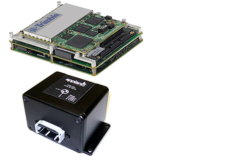
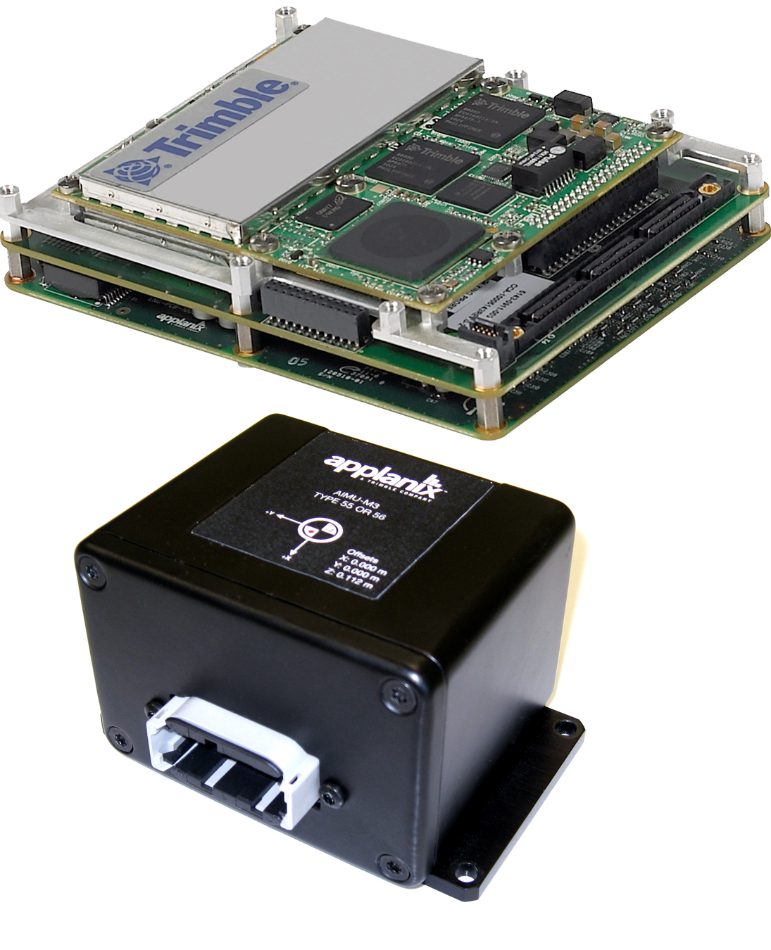
Trimble introduced today the Trimble AP15, the latest member of the AP series of OEM GNSS-Inertial board sets. The introduction was made at the AUVSI 2013 Conference and Exhibition, being held in Washington, D.C.
The AP15 uses a custom Micro Electromechanical Machined (MEMS) based Inertial Measurement Unit (IMU). It is the first product to take advantage of Applanix’ proprietary calibration process — Applanix SmartCal, a new software compensation technology that allows Trimble to achieve exceptional performance from IMUs manufactured specifically for mobile mapping applications.
The AP15 combines high-precision GNSS positioning with Applanix IN-Fusion GNSS-Inertial integration technology, all running on a powerful, dedicated Inertial Engine (IE) board. AP products provide the performance and functionality of Applanix’ POS systems in an embedded form-factor that is specifically designed for third-party manufacturers and systems integrators, Trimble said. The AP Series is designed for a variety of commercial mobile positioning and orientation applications including airborne, terrestrial and marine mapping and guidance for unmanned vehicles.
Combined with a wheel-mounted Distance Measurement Instrument (DMI), the AP15 provides a full 6-degrees-of-freedom navigation solution for land vehicles that is capable of providing robust position and orientation information regardless of obstructions to GNSS-only positioning such as multipath or complete signal loss. Applanix IN-Fusion technology produces uninterrupted position, roll, pitch and true heading measurements of moving platforms by combining IMU data with raw GNSS observables and DMI velocity.
GNSS functionality is provided by a Trimble GNSS module, a dual-antenna, 440 channel, multi-frequency survey-grade GNSS receiver that supports a wide range of satellite signals, including GPS L1/L2/L2C/L5 and GLONASS L1/L2 signals. The module also supports Satellite-Based Augmentation Service (SBAS) corrections, including the U.S. Wide Area Augmentation System (WAAS), European Geostationary Overlay Service (EGNOS), Japan’s Multi-functional Satellite Augmentation System (MSAS) and the OmniStar VBS, HP and XP/G2 corrections.
“Trimble is a leading provider of technology for positioning and orientation solutions and the introduction of the AP15 module continue this tradition,” said Kevin Andrews, product manager. “The AP15 has been designed as a more compact, lighter unit which can deliver excellent performance at lower cost.”
The Trimble AP15 is expected to be available in October of 2013 through Applanix’ sales channel.
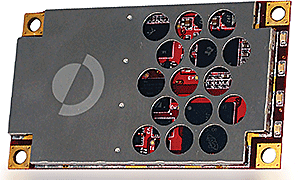
Hemisphere GNSS has launched its new Crescent Vector H200 GNSS compass module, a high-performance receiver for heading, positioning, heave, and attitude. Vector H200 is designed for professional marine, navigation, and land applications in challenging and dynamic environments.
Vector H200 processes L1 GPS and GLONASS signals to deliver precise heading, greater positioning reliability, and better performance in challenging environments, Hemisphere GNSS said. Through using two separate antennas, Hemisphere GNSS’ patented Vector technology computes the heading and pitch or roll angle while stationary or in motion. Vector H200 can compute heading accuracy to 0.02 degrees using a 5-meter antenna separation. A variety of differential correction methods also make it possible for Vector H200 to provide sub-meter to centimeter position accuracy.
Marine industry developers can maximize performance by integrating Vector H200 into their systems for hydrographic and bathymetric surveys, auto-pilots, dredging, and buoys. For land applications, Vector H200 is ideal for aligning cameras, antennas and projectiles, and for machine control applications in agriculture, construction, and mining.
“System integrators have a lot to gain from Vector H200’s powerful combination of navigation and machine control orientation capabilities,” said Ron Ramsaran, Sr. Product Marketing Manager at Hemisphere GNSS. “They will appreciate the performance and value from such a small board package.”
Vector H200 supports SBAS, L-Band and RTK differential positioning solutions and features our exclusive SureTrack technology optimizing the use of GPS and GLONASS signals. Hemisphere GNSS offers precise GNSS antennas to fit a variety of Vector H200 applications.