Collins Aerospace has introduced NavHub-200M, a vehicle navigation system for the international market compatible with military code (M-code) receiver technology. The NavHub-200M is not controlled by the International Traffic in Arms Regulations (ITAR).
Collins Aerospace made the announcement at Eursatory 2022, taking place June 13-17 in Parsis.
NavHub-200M’s message formats and signal modulation techniques ensure faster and more accurate performance for ground vehicles on the connected battlespace, the company said.
NavHub-200M provides assured positioning, navigation and timing (APNT) capabilities while improving overall resistance to existing and emerging threats to GPS, such as jamming and spoofing.
“With GPS-based Selective Availability Anti-Spoofing Module (SAASM) receivers set to become obsolete, it is critical that M-Code receiver technology is made available to ground forces around the world as quickly as possible so they can trust that the signals they receive in a fast-moving, hostile environment are accurate and actionable,” said Ryan Bunge, vice president and general manager, Communication, Navigation and Guidance Solutions for Collins Aerospace. “Our NavHub-200M provides an improved resistance to jamming and interference, as well as advanced security features to prevent unauthorized access or exploitation.”
NavHub-200M also includes the open interface standards and sensor-fusion capabilities required for a GNSS upgrade path, such as that for Europe’s Galileo constellation, as well as the ability to interface with key vehicle sensors such as the inertial measurement unit (IMU) and odometer, among others.
Collins, a leader in APNT solutions for ground platforms, has delivered more than 10,000 navigation systems to military armed forced around the world.
Attendees at Eurosatory can learn more by visiting Collins Aerospace at booth number C523.
The Edge 1040 Solar has breakthrough solar charging and multi-band GNSS technology
Garmin International has announced the Edge 1040 Solar, a GPS-based bike computer featuring solar charging and multi-band GNSS technology.
Photo: Garmin
The Edge 1040 has a Power Glass-branded solar charging lens, giving cyclists more ride time between charges – up to 100 hours in battery saver mode – while multi-band GNSS technology provides more accurate positioning in challenging ride environments, such as dense urban areas or under deep tree cover.
The 3.5-inch touchscreen also features a refreshed, modernized user experience, giving cyclists easier access to key information, the ability to customize the home page and an improved ride summary view.
Its innovative advancements include:
Solar charging: The Power Glass solar charging lens extends battery life to up to 100 hours in battery saver mode, giving cyclists an additional 42 minutes per hour during daytime riding.
Multi-band GNSS technology: Provides better positional accuracy and coverage, even in challenging environments.
Cycling ability and course demands: The device can classify a cyclist’s strengths and weaknesses, focus on improvement and prepare for the demands of a specific course.
Power guide: Recommended power targets make it easier to manage efforts throughout a course.
Real-time stamina insights: Cyclists can monitor and track exertion levels in real-time during a ride.
Simple setup: Custom ride profiles prepopulate based on previous Edge data, ride types and sensors. From there, cycling activity profiles can be managed directly on a compatible smartphone from the Garmin Connect smart device app.
In a world where GPS and other GNSS signals can be easily denied or, worse, spoofed, interest in other forms of navigation has rebounded.
Imagine being able to locate yourself within a couple of centimeters with just your cellphone – deep underground. Or inside a metal structure. Or underwater (assuming you can keep your equipment dry).
No satellite signals, no Wi-Fi ranging, no inertial system. Just the ambient magnetic flux that constantly surrounds us all. Everywhere.
Animals have used the Earth’s magnetic field to find their way for millions of years. People have been using magnetic compasses for over a thousand. Until the advent of GPS, magnetic compasses were foundational tools for aircraft and ship navigation, especially when out of sight of easily recognized landmarks.
Then GPS came along, and almost everyone’s eyes turned to space.
But in a world where GPS and other GNSS signals can be easily denied or, worse, spoofed, interest in other forms of navigation has rebounded. And because GPS helped demonstrate the efficiencies geospatial services provide, users also want those services to be more resilient and to work in places signals from space just can’t reach.
According to Neill, “Our solution builds upon inexpensive magnetometers, smartphones, machine learning, edge computing, and some incredibly complex math to convert raw magnetic data into a source of ultra-precise location data. These relatively recent tech developments allow us to bring things together for a major update to a centuries-old way of navigation and positioning.”
Describing AstraNav as a software tech company, Neill said that the company’s system is “hardware agnostic.” It can work on “just about anything that has a magnetometer. No additional hardware or external connectivity is required, and we can run on any existing operating system.”
The company has partners in retail, automotive and telecom validating the technology. They have also been working with a U.S. Department of Defense (DOD) combatant commander to demonstrate the product, as well as Virginia Tech and its National Security Institute (VTNSI.) “This is not a case of ‘here’s an idea that we hope will materialize,” said Neill. Describing two real-world trials and use cases to the board, he said, “This technology is a reality, and we’re doing it.”
Most previous magnetic navigation efforts relied upon relatively low-resolution maps. An airplane could find its way safely across the ocean using the maps that were available and likely end up within a mile or two of an airport. Much higher resolution maps built through surveys and artificial intelligence are critical to AstraNav’s centimeter-level accuracy with systems that continue to learn on their own.
Intellectual property is AstraNav’s biggest asset. “We have multiple patents filed and pending,” said Neill. “Our IP is what allows us to sense and analyze magnetic fields so finely, develop maps, and make use of very low-cost magnetometers, such as the ones in cell phones.”
Several people at the advisory board presentation expressed surprise that they had not heard of the company and this capability before. “We have been busy getting established as a company, supporting our first commercial clients, and doing demonstrations for various folks within DOD,” Neill explained. “This presentation is by way of our coming out party. We are very eager to become better known and are looking forward to explaining our capabilities one-on-one with potential users.”
Citing an abundance of proprietary material, Neill was unwilling to discuss a lot of technical detail at the public meeting. His short presentation, he said, was to raise awareness and stimulate interest.
The number of those in attendance who after the presentation said they were eager to learn more showed that he was successful.
Dana A. Goward is President of the Resilient Navigation and Timing Foundation
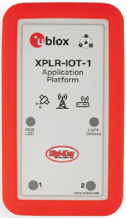
Featuring the full gamut of u-blox technologies and services, the XPLR-IOT-1 enables end-to-end proofs of concepts for IoT products and applications
The u-blox XPLR-IOT-1 IoT explorer kit. (Image: u-blox)
U-blox has announced the u-blox XPLR-IOT-1 IoT explorer kit, an all-in-one package to test, evaluate and validate applications for the internet of things (IoT).
The board hosts an ultra-low-power MAX-M10S positioning module capable of concurrently tracking four GNSS constellations, delivering highly reliable location data wherever GNSS coverage is available.
Integrating all relevant u-blox technologies and services into a capable prototyping platform with a vast selection of sensors and interfaces as well as cloud connectivity, XPLR-IOT-1 makes it easier to explore the potential of IoT applications.
The increasing complexity of IoT devices, which often require satellite-based positioning, Bluetooth low energy, Wi-Fi, and cellular connectivity via, for example, LTE-M is raising the importance of prototyping and validating ideas before bringing them to production. This trend is driving demand for multifunctional application boards like the u-blox XPLR-IOT-1 over evaluation kits (EVKs), intended to comprehensively test a product’s entire feature set.
Prototyping platform
The XPLR-IOT-1 gives users everything they need to prototype low-power IoT use cases such as logistics container trackers, industrial automation, sensor-to-cloud applications, and fleet management solutions. Besides the MAX-M10S positioning module, the board has a u-blox NORA-B106 Bluetooth LE 5.2 radio module that doubles as its main MCU, hosting the application software and controlling the other modules.
Other modules include a u-blox SARA-R510S for LTE-M and NB-IoT cellular connectivity with built-in cloud security, as well as a u-blox NINA-W156 for 2.4 GHz Wi-Fi.
The hardware is complemented by a broad selection of sensors commonly used in IoT applications, including accelerometers and gyroscopes, a magnetometer, and temperature, humidity, pressure and ambient light sensors. A power-on switch, LEDs and user buttons make it easy for users to interact with the device.
The NORA-B106’s powerful Arm Cortex M33 MCU is solely dedicated to running the application software. Clocked at 128 MHz, with 1 MB of embedded flash and 512 kB of RAM, and 8 MB of external flash memory, it offers a solid foundation for development of highly capable solutions.
Integrated antennas for featured technologies, a USB interface and USB charging, a Sparkfun Qwiic I2C connector, and a debug interface contribute to a smooth product development experience, u-blox said.
Native support for u-blox services
The XPLR-IOT-1 offers engineers an easy way to start working with u-blox’s services offering. Included with the kit is a trial of MQTT Anywhere, which delivers ultra-low power by communicating data between the device and the enterprise using the MQTT-SN (MQTT for sensor networks) protocol.
Tracking applications with the most stringent power requirements such as freight container trackers can realize four times longer battery life with u-blox’s positioning in cloud service, CloudLocate, while the CellLocate mobile-network-based location service extends tracking beyond the reach of GNSS signals.
A starting point for commercial end-products
Developers working with XPLR-IOT-1 can use code from u-blox’s ubxlib GitHub repository, a library of software examples for key use cases, to speed up the prototyping of solutions, which can range from wireless sensor networks to indoor and outdoor tracking solutions to industrial or smart building gateways.
Because all hardware design files, software, smartphone app, and online dashboard source code are shared, the XPLR-IOT-1 can also serve as a starting point for commercial end-product design.
“The XPLR-IOT-1 is fully geared towards rapid development, testing, and validation of IoT solutions,” said Pelle Svensson, senior principal, Product Strategy Short Range Radio, u-blox. “Offering a single platform to develop a variety of IoT use cases, the versatile explorer kit reduces the expertise required for hardware, software, and service integration and code development.”
Once launched in June 2022, the XPLR-IOT-1 will initially be sold via Digi-Key.
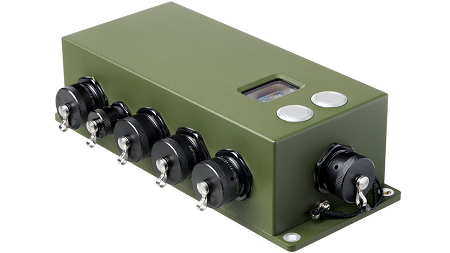
New M-code GPS receiver enables precision strike capabilities in contested environments
Image: BAE Systems
BAE Systems unveiled its newest advanced M-Code GPS receiver for guided weapons and other small applications at the ION Joint Navigation Conference, taking place this week in San Diego.
The Strategic Anti-jam Beamforming Receiver – M-Code (SABR-M) enables precise geolocation and strike capabilities in highly contested battlespaces. It delivers accurate position, velocity, altitude and timing data, as well as strong protection against GPS signal jamming and spoofing – critical capabilities for unmanned aerial vehicles (UAVs), precision-guided munitions (PGMs), and missiles in threat environments.
SABR-M integrates receiver technology with advanced antenna electronics in a small, hardened package designed to meet challenging performance requirements, such as weapons applications. It is the most capable integrated anti-jam GPS receiver and the first integrated M-Code receiver available for weapon systems, according to BAE Systems.
“We’re making our full portfolio of military GPS solutions M-code-compatible to meet warfighters’ need for reliable positioning, navigation, and timing data to achieve their missions,” said Doug Lloyd, director of weapon systems GPS at BAE Systems. “SABR-M enables small platforms with challenging environmental conditions to get where they’re going despite interference.”
The compact (4.5 x 6 x 1 inch) SABR-M meets size, weight, power, cost (SWaP-C) and thermal requirements for space-constrained military applications. It uses advanced beamforming technology to improve GPS signal reception and counter threat signals. SABR-M is form-compatible with previous generations of the field-proven SABR receiver, which are integrated on low-cost precision weapon systems and long-range cruise strike missiles.
SABR-M will be fully qualified for production by the end of 2022. Production will take place at BAE Systems’ modern facility in Cedar Rapids, Iowa, which is in the final stages of construction. The purpose-built 278,000-square-foot factory and research center will be home to 700 military GPS experts in BAE Systems’ Navigation and Sensor Systems business.
Collaboration supports emergency services across the European Union
Galileo-supported E112 will result in faster response times and more lives saved. (Image: EUSPA)
Keysight Technologies Inc. is collaborating with DEKRA to ensure that chipset and device vendors can validate E112 caller location (universal European emergency number) functionality in compliance to a new European Union (EU) regulation.
The collaboration leverages GNSS and c (LBS) to verify E112 regulatory test cases used to validate mobile phones sold into the European market. The new regulation supports emergency services across the European Union by reducing response times from rescue services to save more lives.
“Keysight is pleased to expand the company’s collaboration with DEKRA,” said Muthu Kumaran, general manager of Keysight’s Device Validation Solutions business. “With Keysight’s test solutions, DEKRA supports a global ecosystem of smartphone vendors by validating that their products are in compliance to the new regulation, newly created to improve emergency services’ ability to locate individuals in need of assistance from the fire brigade, medical teams or the police.”
Keysight’s network emulation solutions enable DEKRA to validate E112-related test cases regulated by an EU-issued guideline document to assist notified bodies in the assessment of E112 compliance. The new EU regulation (Delegated Regulation (EU) 2019/320) went into effect on March 17, 2022. It mandates that all new mobile phones sold in the EU need to support GNSS technology based on the Galileo constellation, advanced mobile location (AML) protocol and Wi-Fi communications technology. As a result, emergency response call centers can accurately pinpoint the caller’s location.
“DEKRA is founded on the principles of safeguarding human interaction with technology and environment,” said Juan Carlos Mora, vice president, Business Line Connectivity of Service Division, Product Testing at DEKRA. “This is why we are pleased to extend our collaboration with Keysight, which offers DEKRA the regulatory device test solutions needed to quickly and confidently validate E112 caller location functionality per the EU’s latest mandatory requirements.”
Keysight’s device test solutions for regulatory and conformance validation are based on common hardware and software platforms for comprehensive test-case coverage. Keysight’s LBS solutions also support assisted GNSS (A-GNSS) test functionality. This enables users to comprehensively address 5G new radio (NR) conformance requirements mandated by the Global Certification Forum (GCF) and PTCRB, an organization comprised of North American mobile operators.
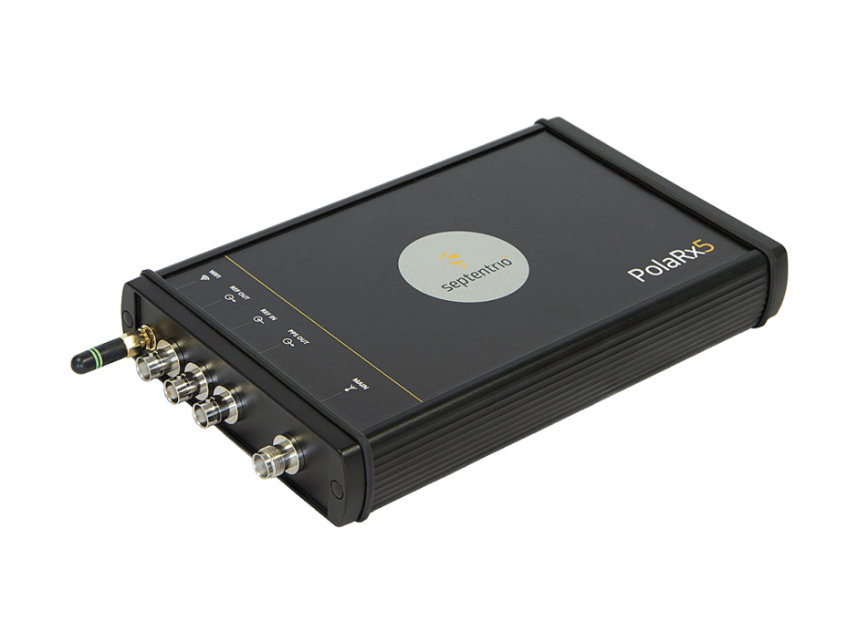
The PolaRX5 GNSS reference receiver. (Photo: Septentrio)
Septentrio, a leader in high-precision GNSS positioning solutions, has launched Open Service Navigation Message Authentication (OSNMA) on its high-end PolaRx5 reference receiver series.
OSNMA offers end-to-end authentication on Galileo’s civilian signals, protecting receivers from GNSS spoofing attacks. OSNMA adds another layer of security to Septentrio’s existing AIM+ anti-jamming and anti-spoofing technology.
This high level of resilience is especially important for reference receivers in applications that require assured PNT as well as in stationary critical infrastructure, which is especially vulnerable to GPS spoofing.
The Septentrio PolaRx5 receiver with OSNMA technology will be showcased in booth 220 at the ION Joint Navigation Conference, taking place June 6-9 in San Diego.
“We are excited to offer OSNMA anti-spoofing technology now in our scientific and reference GNSS receivers,” said François Freulon, head of product management at Septentrio. “The addition of OSNMA to Septentrio’s already strong anti-jamming and anti-spoofing technology takes our receivers to a new level as resilient positioning and timing solutions for industrial applications and critical infrastructure.”
Septentrio has also updated the PolaRx5 product range with the latest RINEX format to support version 3.05 as well as version 4.0. With these updates, PolaRx5 becomes a leading scientific and reference receiver family supporting all of the new GNSS technologies introduced in 2022, Freulon said.
The OSNMA authentication mechanism is also available on the mosaic GNSS module family and on Septentrio’s latest OEM boards.
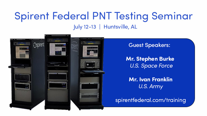
Guests include Stephen Burke from Space Systems Command and Ivan Franklin from the Assured Positioning, Navigation and Timing/Space (APNT/Space) Cross-Functional Team (CFT).
The seminar will take place in person in Huntsville, Alabama, July 12-13, and will provide extensive training on PNT applications using Spirent’s simulation solutions.
Burke will provide an update on Military GPS User Equipment (MGUE) for Increment 1 and Increment 2, as well as a briefing on the Space Systems Command PNT restructure. Burke is deputy to the Senior Materiel Leader, GPS User Equipment Acquisition Delta, for the Military Communication and PNT Directorate within U.S. Space Force Space Systems Command.
Franklin, Deputy APNT Signature Effort for the U.S. Army APNT/Space CFT, will share the latest on U.S. Army APNT, which is influencing the way soldiers operate in degraded and denied environments.
“Providing hands-on training for customers, or prospective customers, and discussing nascent PNT advancements at our annual training seminar is the highlight of our year,” said Roger Hart, director of engineering for Spirent Federal. “We work closely with the U.S. government and military and are pleased Stephen and Ivan have accepted our invitations to share their vital information and expertise with the attendees.”
Other seminar topics include
advanced jamming and in-the-field spoofing mitigation
encrypted GPS M-code and Y-code
complementary PNT, including inertial navigation systems
controlled reception pattern antennas (CRPA)
a patented approach to testing in anechoic chambers.
BAE Systems has expanded the capabilities of its Digital GPS Anti-Jam Receiver (DIGAR) by enabling beamforming with Trimble receivers, in addition to its own receivers.
DIGAR’s beamforming capabilities increase the level of GPS jamming protection for aircraft by a million-fold, helping pilots execute their missions in contested environments.
BAE Systems’ engineers in Cedar Rapids, Iowa, developed software to ensure the compatibility of its antenna electronics with industry-standard embedded GPS inertial navigation system (GPS/INS) technology, enabling fast communication with transmitter electronics for superior beamforming.
DIGAR beamforms with both BAE Systems receivers and Trimble GPS receivers embedded in aircraft GPS/INS, as well as federated GPS systems and stand-alone GPS receivers.
“The modern battlespace has evolved, and peer state positioning, navigation, and timing threat systems are challenging our ability to conduct combat operations in the place and manner of our choosing,” said Greg Wild, director of Navigation and Sensor Systems at BAE Systems. “By combining DIGAR’s beamforming with trusted inertial navigation system data, we offer the highest level of jamming protection available today.”
DIGAR is a high-performance military GPS-based system for fixed-wing, rotary-wing and unmanned airborne platforms. It combines field-proven antenna electronics, advanced signal-processing, and beamforming techniques to improve the reliability of positioning, navigation and timing data in the presence of disruptive electromagnetic signals.
DIGAR is also compatible with the advanced M-code – delivering additional security to the warfighters who rely on it.
BAE Systems’ anti-jamming GPS technology has defeated powerful and sophisticated adversary threat systems in testing and combat, and is available for airborne, shipborne and ground vehicle applications. The company’s military GPS business is based in Cedar Rapids, Iowa, where it is building a 278,000-square-foot state-of-the-art research and manufacturing facility scheduled to open this year.
Nestwave has released a white paper that considers the challenges associated with integrating accurate geolocation into compact, battery-powered, low-cost internet of things (IoT) nodes.
The technical paper “Minimizing Power Budgets to Enable Geolocation on Every IoT Device” is targeted at engineers and developers looking to add accurate positioning functionality to IoT technologies where power requirements must be kept to an absolute minimum.
Topics covered include:
why conventional tracking architectures are not suitable for many IoT implementations
the importance of factors such as time-to-first-fix (TTFF)
the number of fixes and levels of integration in determining power consumption.
The paper introduces new ways of handling positioning signal acquisition, ranging and tracking, and proposes solutions that eliminate the need for a separate GNSS-integrated circuit and that offload energy-intensive computation to the cloud.
“Tracking will be an important element in the evolution of the IoT, which means making accurate geolocation viable for every single IoT node is absolutely critical,” said Ambroise Popper, Nestwave CEO. “This paper explains why traditional solutions are too power-hungry, too large and too expensive to meet the energy, form factor and cost constraints of most IoT devices and introduces solutions for addressing the challenge.”
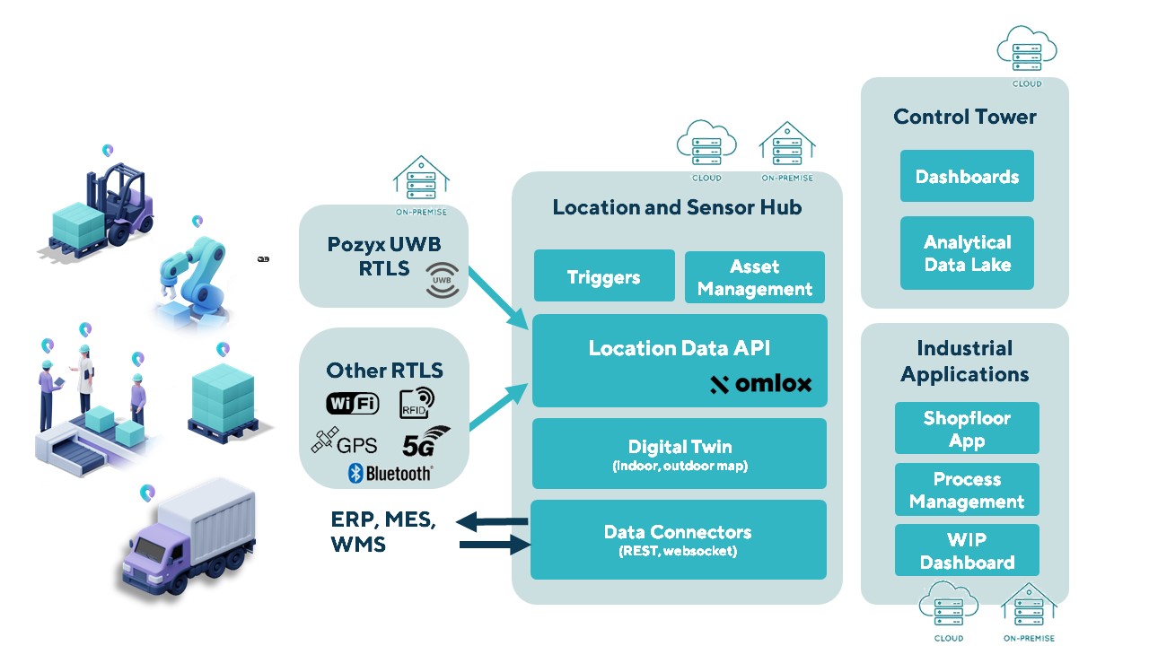
The Pozyx Platform is an asset tracking and identification solution for seamless indoor and outdoor tracking, based on the omlox hub and supporting multiple location technologies.
The omlox hub is an open standard for real-time location systems (RTLS) that combines location data from GPS, ultra-wideband, 5G, radio-frequency identification, Wi-Fi and Bluetooth.
The Pozyx Platform offers a seamless indoor/outdoor transition with zoom-in from a worldwide map to a detailed indoor map, showing highly accurate locations up to 10 cm. It is designed for smart manufacturing, providing a supply-chain solution that supports Industry 4.0.
It tracks and identifies any asset, providing real-time data to facilitate warehouse and inventory control, keep track of critical tools, and slash lost asset costs.
An aviation industry coalition is voicing concern to Transport Canada about elements of a proposed mandate that will require aircraft flying in Canada to be equipped with the Automatic Dependent Surveillance-Broadcast (ADS-B), also called the Next Generation Air Transportation System, or NextGen.
ADS-B uses GNSS technology to calculate an airplane’s precise location, speed and direction. This information is transmitted twice per second, providing greater situational awareness for air traffic controllers.
The mandate in Canada requires aircraft to implement 1090ES ADS-B in two phases over the next four to five years. It takes effect for Class A and B Canadian airspace (above 12,500 feet) on Feb. 23, 2023, and Class C, D, and E airspace no earlier than 2026.
Space-Based Transceivers
The proposed mandate will also require antennas capable of communicating with both ground-based and space-based transceivers (referred to as antenna diversity). The United States uses ground-based ADS-B stations, which are confined to line-of-sight reception between the aircraft and ground receivers.
Space-based ADS-B does not have this limitation, but requires antennas on top of the aircraft to provide the required fidelity to allow for air traffic separation.
“This would constitute an equipage mandate for most U.S. operators wanting to fly to Canada, most of which have recently equipped to meet U.S. requirements,” said Jim McClay, director of airspace, air traffic and security for the Aircraft Owners and Pilots Association (AOPA). “To comply, many operators will need to install new antennas on top of their aircraft as well as possibly replace their ADS-B units. The costs of complying will be significant and would be borne only by aircraft owners.”
A recent AOPA survey of members in border states revealed that most U.S. operators are unaware of the coming mandate and almost half of respondents who regularly fly to Canada indicated they would cease flying to Canada altogether in the face of the mandate.
Lack of Installers
The industry coalition also agrees that it is highly doubtful that there are enough avionics installers to complete the needed upgrades in time to meet the mandate’s deadlines.
“Due to these concerns, AOPA is urging a delay of the Nav Canada equipage mandate until a determination can be made on the cost impact to purchase and install the required equipment and discussions on potential alternative solutions are held,” McClay said.
Other Countries
According to Nav Canada, the equipage requirements of Canada’s ADS-B mandate are in line with those of a growing number of other countries in the world. “The adoption of satellite-based surveillance technology ensures long-term alignment with the global aviation system,” the company stated. Nav Canada provides services to Canadian airspace such as air traffic control and weather advisories.
Members of the coalition include the Canadian Owners and Pilots Association, General Aviation Manufacturers Association, Garmin, the Canadian Business Aviation Association, AOPA and others.
Coalition members share concerns that the mandate being pursued by Nav Canada and Transport Canada does not appear to be going through the full consultative process, and will submit their concerns over the next several weeks.