Thales and Syrlinks have signed a multi-year contract with the French defence procurement agency (DGA) to develop a new generation of tiny, high-performance atomic clocks.
Code-named Chronos, these new quantum clocks will meet the requirements of numerous civil and military applications. With their very high stability (error of less than 1 second in tens of thousands of years), defence electronics equipment will be able to operate when a GNSS signal is unavailable, for example due to hostile jamming.
Working with the procurement agency, the partners will help safeguard France’s technological sovereignty in GNSS-denied positioning, guidance, navigation and encrypted military communications. In civil applications (5G network synchronization, transport, energy, etc.), the Chronos quantum clocks will deliver low price and high performance to French and international customers.
Large swaths of the modern economy now rely on satellites for synchronization. GNSS technology provides the precise time reference for critical infrastructure such as 4G/5G networks, internet, air and rail transport, energy networks, global banking transactions and high-frequency trading, which would quickly fail if the signal were unavailable. In view of this high level of dependency, backup systems are needed to ensure that our civil and military infrastructure can continue to operate even if the GNSS timing signal is unavailable.
Thales’s industrial facility in Vélizy-Villacoublay and the Thales Research & Technology center in Palaiseau, both near Paris, have the industrial capabilities and talent to manufacture the atomic and optical core of these future quantum clocks.
Syrlinks — a French company based in Rennes, Brittany — specializes in satellite radiocommunications, radionavigation systems and miniature atomic clocks, and its products were selected to equip 650 satellites for the American operator OneWeb. The company will develop the electronic brain of the Chronos clock and guarantee its high-precision timing function.
The CNRS will provide critical scientific support for this project via its SYRTE (Observatoire de Paris) and Femto-ST (Université de Franche-Comté) joint research units.
South Korea has successfully launched a precision aviation satellite Thursday by leasing space on Malaysia’s MEASAT-3d communication satellite for 15 years, reports The Korea Herald. The first satellite for the Korea Augmentation Satellite System (KASS) will improve the accuracy and reliability of GPS signals for pilots, increasing airline flight safety.
The satellite lifted off from Guiana Space Center in Kourou in French Guiana at 6:50 a.m. Thursday (Seoul time), and successfully separated from the rocket at around 7:18 a.m. after the fairing and first stage rocket separations.
In development since 2014, the KASS system can improve the GPS position error to 1.0 to 1.6 meters from the current 15-33 meter level in real time to ensure positioning reliability throughout the country.
The government plans to begin a pilot service around December before its full-fledged operation next year.
South Korea is the seventh country to have a geosynchronous satellite system officially registered with the International Civil Aviation Organization (ICAO). The others are the United States, Russia, China, the European Union, India and Japan.
The Korea Augmentation Satellite System will improve airline safety over Korea. (Photo: ugurhan /iStock/Getty Images Plus/Getty Images)
Harxon has launched a high-precision GNSS antenna, the HX-CSX633A. The HX-CSX633A has an upgraded architecture for more durable use and more flexible installations, making it suitable for agricultural vehicles, small robots and surveying applications.
Photo: Harxon
The HX-CSX633A features a durable, future-proof design with an IP67 waterproof housing. It meets MIL-STD-810-H for vibration and shock, increasing robustness for use under high-vibration conditions. The HX-CSX633A supports flexible installations including magnetic mount, screw mount and pole mount. Consequently, integrators can be confident this powerful antenna can be used in system designs for years to come, the company said.
The HX-CSX633A is fully functional, powerful and stable. The phase center remains constant with a multi-point feeding design. The ability to receive low-elevation signals with high gain and wide beamwidth makes it suitable for tracking visible satellites in tough environments, Harxon said.
The antenna’s low-noise amplification (LNA) features excellent out-of-band rejection, which can suppress electromagnetic interference and prevent disconnection when receivers are operated in complex electromagnetic environments.
Key Features of the HX-CSX633A:
supports GPS, GLONASS, Galileo, BDS, QZSS, IRNSS and SBAS signal reception
stable phase center guarantees positioning accuracy within the millimeter-level
strong anti-interference ability to endure challenging operating environments
M3 Systems and TilT Consulting on June 1 were declared winners of the MyEUspace Competition 2021 for their passive radar for detection and localization of obstacles based solely on GNSS signals.
The SANGENE project (Sens And Navigation on GNSS ENvironment Estimation) aims to demonstrate the concept of an integrated GNSS-based passive radar for the detection and first localization of obstacles.
The SANGENE solution is a passive radar technology based solely on GNSS signals integrated into a localization and navigation device currently available onboard an aircraft or a drone. Today’s operational navigation equipment often use a combination of equipment to identify and locate other carriers or obstacles, but these means do not permit detection and visualization of non-equipped or uncooperative carriers, and can be a source of danger.
As “signals of opportunity,” GNSS signals can be used for detecting obstacles. With reflected signals, GNSS satellites behave as multiple radar signal sources that are widely available while remaining discrete.
This principle of passive detector also makes it possible to increase the localization capacity of the GNSS devices already present, without having any major architectural changes to their design.
Within a few months, this solution has passed from a first level of concept and definition to an implementation model. With the impetus provided by the competition, the validation phase will soon begin.
The MyEUspace Competition was organized by the European Union Agency for the Space Program (EUPSA) to support development of innovative commercial solutions — such as mobile apps or hardware-based solutions — that leverage Galileo or Copernicus EU space data.
Burkhard Boeckem and a Boston Dynamics robot dog share insights into smart digital realities. (Photo: Hexagon)
At HxGN LIVE Global 2022, in-person attendees experienced the full breadth of what the flagship conference has to offer for the first time since 2019. The conference is taking place this week at the Venetian hotel in Las Vegas.
Tuesday began with a keynote address by Burkhard Boeckem, chief technology officer, who discussed the importance of smart digital realities and their role in the potential of the metaverse to impact and enhance the physical world. Hexagon’s technology platform Xalt enables intelligence at scale. By integrating sensors and data integration across systems and solutions, like the BLK series and HxDR, Xalt provides the next level of connectivity to harness and utilize data for autonomous systems.
Summit-specific keynotes by speakers from Hexagon, its partners and sponsors provided expertise on issues, solutions and innovations shaping and reimagining various industries.
The Digital Innovation in Construction summit begins. (Photo: Hexagon)
Tuesday was also the first day of breakouts for all summits, with more than 100 sessions throughout the day covering everything from training and tips for Hexagon products to project success stories, panel discussions of industry trends, and a look at the precision engineering of Formula 1 cars with Hexagon partner Oracle Red Bull Racing. Sessions continue through the close of the conference on Thursday.
The Zone, the massive technology expo floor, officially opened for the first time this morning, where attendees explored some of the latest advancements, products and solutions available across seven summit-specific “islands” offering hands-on demonstrations and an opportunity to ask the questions that will help them make the best use of autonomous technology in their field.
Surveyors get the lay of the land at the Pure Surveying Island. (Photo: Hexagon)Advances in digital construction were provided by Leica Geosystems. (Photo: Hexagon)
In the evening, summit events took attendees around the grounds of the Venetian resort for various experiences.
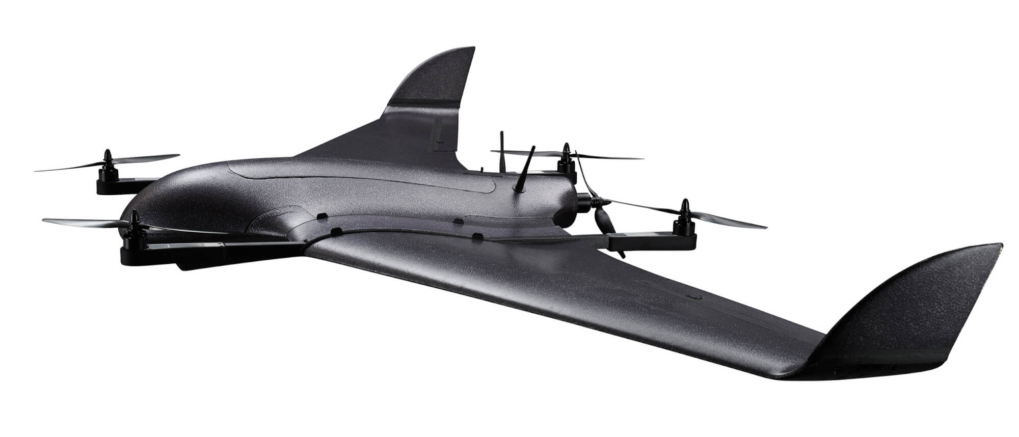
DeltaQuad has successfully integrated an advanced GPS anti-jamming system into its unmanned aerial vehicle (UAV). The DeltaQuad drone equipped with the system was flown in autonomous mode close to an active military jamming system.
Even while being hit directly by a military-grade GPS jamming platform, the system maintained a solid GPS lock and the vehicle managed to autonomously resume its mission without interruption.
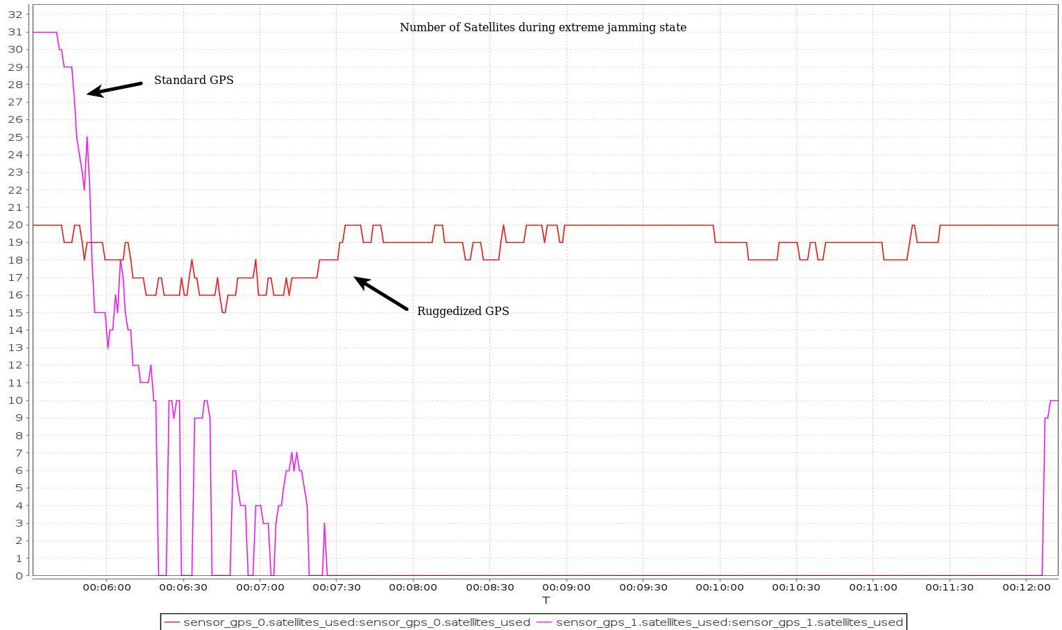
For testing purposes, a ruggedized GPS-based navigation system was installed with the standard GPS-based navigation system. As the vehicle came in range of the GPS jamming system, the standard solution quickly lost all positional awareness, while the ruggedized system maintained a number of satellite locks, even while flying directly over the jammer at close range.
Test results. (Image: Deltaquad)
In addition to the ruggedized GPS solution, the DeltaQuad UAV is equipped to maintain live aerial intelligence, even in tough environments. The transmission system on the DeltaQuad uses frequency hopping spread spectrum (FHSS) techniques to mitigate attempts to disrupt the communication links, and also uses redundant video and communication links.
The DeltaQuad is an industrial-grade vertical takeoff and landing (VTOL) fixed-wing UAV that performs fully autonomous surveillance missions. The platform offers a live video stream from a surveillance sensor for real-time reconnaissance missions.
Airbus Helicopters has selected Safran Electronics & Defense to supply its SkyNaute navigation systems to equip future H160M helicopters, developed as part of the France’s joint light helicopter program. The contract follows a December 2021 order from the French Ministry of the Armed Forces for 169 Guépard helicopters.
SkyNaute is an ultra-compact hybrid GNSS/inertial navigation system based on Safran’s patented technology — the hemispherical resonator gyroscope crystal. It offers virtually unlimited service life, a robust design for severe environments and ultra-high reliability, Safran said.
With its combination of high integrity and precision, the SkyNaute navigation system guarantees a high level of performance, even when GNSS signals are absent or jammed. It will enable H160M crews to perform their missions in challenging theaters of operations, the company said.
Customizable system provides robust positioning without added site infrastructure for IHI Corp.
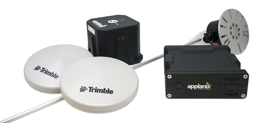
Photo: Trimble
Trimble has announced the first deployment of its map-based localization system for land-based autonomous vehicle applications.
IHI Corp., a heavy industry manufacturer based in Japan, will retrofit its existing container and haulage trucks with a customized Applanix POS LV system as part of its broader autonomy capabilities for the transport of goods around industrial facilities.
Map-based localization provides precise positioning and orientation estimation, augmenting GNSS/inertial data, which is critical for safe and efficient autonomous vehicle operations. The ability to provide IHI Corp. a full workflow and real-time data ensures seamless integration into IHI’s truck design.
The custom-built, locally supported system leverages Trimble’s engineering capabilities and technology to provide reliable performance across a variety of challenging environments, the company said. Using this system, IHI Corp. can provide robust positioning for its autonomous fleet without additional site infrastructure, lowering capital expenditure costs and improving scalability.
Tailoring POS LV to work within IHI’s unique specifications and existing autonomous platform, the map-based localization system couples an inertial navigation system (INS) with simultaneous localization and mapping-based (SLAM) capabilities, and works with several types of sensors, including lidar. POS LV provides an accurate base map using post-processed data and localizes vehicle positioning in real time, enabling the reliable and safe autonomous operation of industrial vehicles.
IHI continually enhances its work environments, while also compensating for varying labor scenarios and personnel shortages. This makes the need to automate transportation critical to operations. The complexities of the evolving industrial manufacturing environment require solutions that can be tailored to a customer’s specific application requirements.
By partnering with Trimble, IHI can develop a retrofit system that addresses two major challenges — affordability and reliability — within the autonomous operation of large-scale industrial equipment.
Tall buildings block GNSS signals, making satellite navigation in urban canyons very challenging. (Photo: RoschetzkyIstockPhoto/iStock/Getty Images Plus/Getty Images)
GPS positioning for navigation and mapping is challenging in urban environments, where GPS signals often are blocked by tall buildings. The following three papers — to be presented at the Institute of Navigation (ION) GNSS+ conference Sept. 19–23, 2022 — explore ways to solve that problem. The full papers will be available at www.ion.org/publications/browse.cfm following the conference.
ALGORITHMS FOR URBAN MAPPING
In this work, the authors use an urban environment model incorporating visibility predictions and remote-sensing techniques, which they tested in a sensor-equipped vehicle in Denver. They use an interacting multiple model (IMM) filter that uses extended Kalman filters to build and verify a map of the signal environment in an urban-canyon setting. The techniques will give ground-vehicle operations the ability to plan for blocked and delayed signals for global path planning.
Zeller, Emma; Strandjord, Kirsten, University of Minnesota; and Wang, Pai, Shanghai Jiao Tong University; “Algorithms for Mapping the Urban Signal Environment for Navigation of Ground Vehicle Operations.”
ADDING VISUAL TO GNSS/INS
GNSS real-time kinematic (GNSS-RTK) positioning is a key technology for surveying and mapping applications. To extend the capability of GNSS in difficult environments, a tight coupling between GNSS-RTK and an inertial navigation system (INS) can greatly improve the results. If the time spent in a GNSS outage is too long or if the kinematic of the survey is too weak, the GNSS/INS solution can be compromised with high navigation errors, ultimately making it impossible to align the heading angle at initialization.
This paper presents an innovative solution to overcome GNSS/INS limitations, minimizing system complexity by using a tightly coupled GNSS/INS solution with a monocular visual inertial SLAM system. This solution is capable of initialization in a few seconds and is very reliable in the long term. This vision/INS/GNSS coupling increases the overall RTK fix rate and broadens the availability of high-precision navigation solutions under challenging conditions.
Bénet, Pierre; Saussay, Brice; Saidani, Mourad; and Guinamard, Alexis; SBG Systems; “Tightly Coupled Inertial Visual GNSS Solution: Application to LIDAR Mapping in Harsh and Denied GNSS Conditions.”
USING 3D BUILDING MODELS
To solve the urban-navigation challenge, the authors propose using a 3D building model to assist GNSS positioning. This type of algorithm is named the 3D building model aided GNSS (3DMA GNSS). It can predict measurement errors and the visibility of the satellites, as line-of-sight or non-line-of-sight. The solution is then derived from the likelihood of the observed and predicted measurements over candidate locations.
The authors propose an innovative method for evaluating the reliability of building models based on the awareness of sky visibility in a specific geographic context. Sky visibility estimation is improved with use of a support vector machine regression and considering low-Earth-orbit (LEO) constellations. The real-time sky visibility could present the update of the surrounding buildings, whereas the predicted sky visibility based on the existing building models remains unchanged. Making use of this inconsistency, the authors could identify areas with the updated building. Additionally, the impacts of the building update monitoring on the 3DMA GNSS are evaluated in an urban canyon.
Xu, Hao-Sheng and Hsu, Li-Ta; Department of Aeronautical and Aviation Engineering, The Hong Kong Polytechnic University; “Urban Buildings Update Monitoring Based on Sky Visibility Estimation using GNSS and LEO.”
A roundup of recent products in the GNSS and inertial positioning industry from the June 2022 issue of GPS World magazine.
SURVEYING & MAPPING
Base/Rover
For survey-grade GNSS accuracy anywhere
Photo: Bad Elf
A base/rover feature built upon the Flex GNSS receiver brings affordable centimeter-level accuracy to surveyors and geospatial professionals working anywhere in the world. The solution consists of two Flex GNSS receivers and two UHF radios, allowing customers to perform high-accuracy field data collection in areas where traditional real-time kinematic (RTK) corrections or cellular coverage is not available. Existing Flex customers can upgrade by adding Flex radio kits (pictured). The Bad Elf Flex enables data collection either as a standalone receiver or paired with apps on iOS or Android phones and tablets.
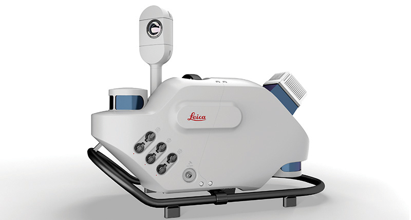
The Leica Pegasus TRK reality-capture mobile-mapping system features artificial intelligence (AI), autonomous workflows and intuitive interfaces. To comply with privacy regulations, its AI can identify and blur identifiers, such as people and vehicles, in real time. Features include advanced dynamic laser scanning and an expandable imagery system for recording, measuring and visualizing. It enables long-range mobile mapping for asset management, road construction, rail, critical infrastructure, utilities and more. The system also can create high-definition basemaps for autonomous vehicles.
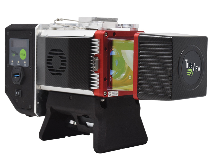
The True View 645/650 is the latest 3D Imaging System (3DIS) from GeoCue. Combined with the True View EVO data-processing software suite, it includes the full post-processing software workflow and directly integrates with Applanix POSPac. EVO supports the creation of project deliverables including ground classified point clouds, surface models, contours, digital elevation models (DEMs), volumetric analysis and wire extraction. The system delivers colorized lidar deliverables with accuracy better than 3 cm root-mean-square-error (RMSE) for the True View 645, and better than 2 cm for the True View 650.
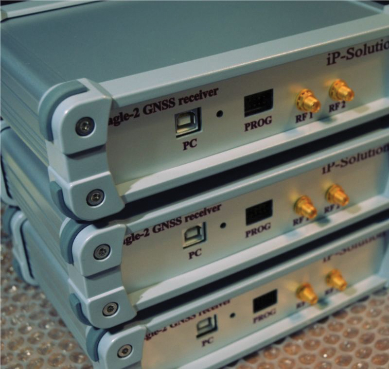
The Eagle-2 works with software-defined receivers in real time or records GNSS signals for post-processing. For post-processing, Eagle-2 supports most third-party receivers, such as MATLAB and C/C++ receivers. The front end allows a user to work with two perfectly synchronized channels connected to two antennas. The Eagle-2 supports GPS, Galileo, GLONASS , BeiDou, QZSS and SBAS.
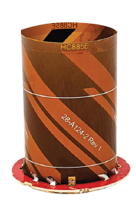
The housed HC885XF and embedded HC885EXF dual-band eXtended Filtering (XF) antennas receive GPS/QZSS L1/L5, GLONASS G1/G3, Galileo E1/ E5a/b, BeiDou B1/B2/B2a and L-band corrections services. They have been tuned to provide optimal support for the entire L1/G1/E1/B1/L-band correction and L5/G3/E5/B2 bands. The housed version, HC885XF, weighs ~42 g and is enclosed in a robust, military-grade IP67 plastic enclosure. The embedded version, HC885EXF, weighs ~8 g and is easily mounted with an embedded helical mounting ring.
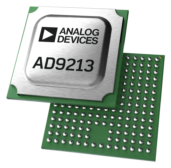
Sets performance benchmarks for harsh environments
Photo: Analog Devices
The AD9213S-CSH is a highly integrated RF analog-to-digital converter that handles 12-bit, 10.25-giga-samples per second. It is the company’s fastest ADC available for the space environment. The AD9213-CSH enables the next generation of software-defined systems for satellite communications, radar and remote sensing. The high sample rate and integrated post-processing enable further performance gains for narrow-band applications.
Skyward has published a free ebook, Adding Drones to the Enterprise, to provide guidance on establishing a corporate drone program. According to Skyward, the most efficient and effective drone programs are the lowest risk and most compliant. Topics covered include how to present the business value of a drone operation to corporate executives; how risk managers can optimize the workflow to ensure maximum safety; best practices for risk mitigation and regulatory compliance; tips for collaborating with legal and compliance teams on a general operating manual; and how to provide full transparency to corporate stakeholders.
DJI’s all-in-one solution for professional drone operators includes the DJI Matrice 30 (M30) drone integrated with DJI FlightHub 2 fleet-management cloud software and DJI Dock for autonomous docking and recharging. The integrated solution is suitable for Enterprise drone users such as public safety agencies, infrastructure inspectors and energy operators. The M30 model is designed for rugged professional uses, while the fact that it fits in a backpack makes transportation and setup fast. The DJI Dock is an autonomous takeoff, landing and charging station allowing fully automatic, programmed flights with the DJI M30 Series (Dock Version). After setup, the fully charged M30 drone can take off from the dock through FlightHub 2 programmed automatic missions anywhere within a seven-kilometer radius.
The AlphaAir 1400 (AA1400) and AlphaAir 2400 (AA2400) lidar systems are lightweight, compact airborne scanners easily installed on various UAV platforms or small survey aircraft and helicopters. They are adapted to high-density point-corridor mapping applications, day or night, under leaf-on and leaf-off conditions or with dense vegetation to provide reliable results. Combined with industrial-grade GNSS receivers and high-precision inertial measurement units (IMUs), the AA1400 and AA2400 provide 2 cm to 5 cm survey-grade accuracy. They also integrate Riegl VUX lidars with waveform-lidar technology, allowing echo digitization and online waveform processing.
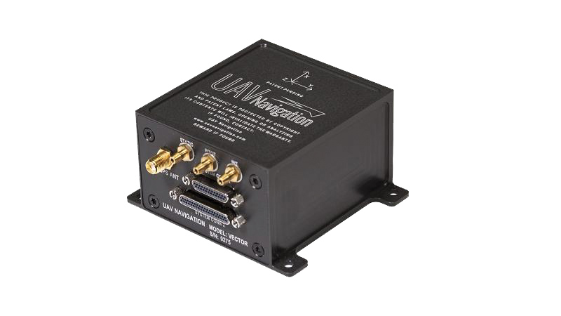
The VECTOR-600 is a robust, dependable autopilot with built-in physical and logical redundancy, allowing it to survive all individual sensor failures while maintaining accurate estimates of attitude and position. It works for fixed-wing, rotary-wing and vertical-take-off-and-landing UAVs. It provides exceptional performance in GNSS-denied environments and when there is a jamming threat. The VECTOR-600 features high quality components and an electromagnetic-resistant design tested to MIL-STD 461.
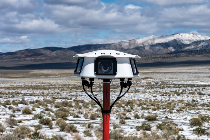
Casia G is a ground-based detect-and-avoid surveillance solution that provides 360° optical detection with alerts. It enables operators to avoid both cooperative and non-cooperative aircraft for safe beyond-visual-line-of-sight (BVLOS) flight. Casia G creates a perimeter of monitored airspace for UAVs to perform work safely, without additional payload. It is suitable for operations in fixed or temporary locations, supporting drone-in-the-box operations and augmenting or replacing human visual observers. Casia G sees the entire sky, with uniform probability and resolution, 10 times per second, covering a majority of small UAS use cases.
Will GPS modernization and improvements in GPS receivers and antennas reduce or even eliminate the need for correction services for most applications?
Julian Thomas, managing director, Racelogic
“For most applications, I think the answer is yes, the need for correction services will be reduced. When you can get <1m without external corrections, the majority of conventional accuracy requirements are fulfilled. However, increases in accuracy always open up new applications for GPS, so correction services will still be required.” — Julian Thomas
Racelogic
Miguel Amor, chief marketing officer, Hexagon’s Autonomy & Positioning Division
“Correction services will continue to be in demand for those markets and applications requiring precision and accuracy below a few inches, 2-3 sigma confidence levels and high reliability, availability and integrity. While ionospheric errors have been low in the past 15+ years, correction services will also provide ionospheric models beneficial in periods of higher activity. Even as there are improvements in user equipment and signal modernization, the demand for correction services will increase in line with these improvements and new functionalities to enable more markets and applications worldwide.” — Miguel Amor
Hexagon’s Autonomy & Positioning Division
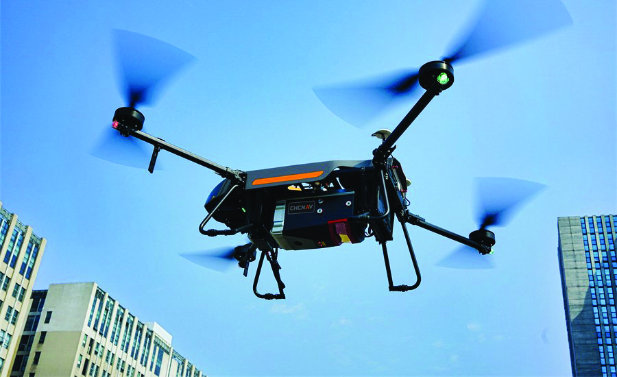
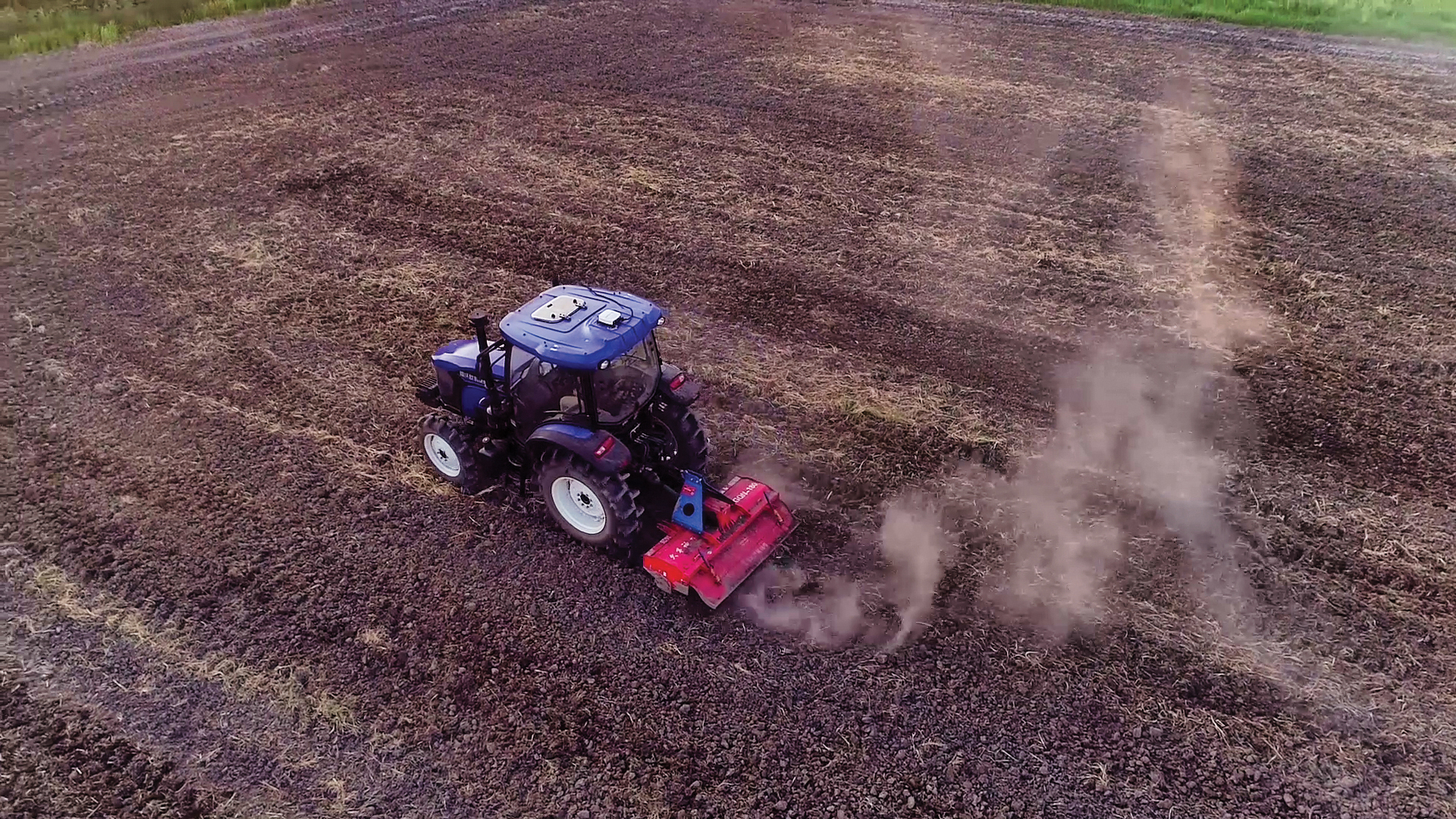
PRECISION AGRICULTURE reduces inputs of seed, water, fertilizer, pesticides and fuel. (Photo: CHCNAV)
Precision agriculture refers to the ability of farmers to observe, measure and respond more precisely to the variability of soil and crop characteristics within and between fields by using maps of these characteristics and GNSS navigation. It enables them to reduce inputs of seed, water, fertilizer, pesticides and fuel while increasing outputs. Adoption of precision agriculture technology and practices has increased steadily over the past three decades and now covers the majority of U.S. farmland.
We asked three companies that manufacture GNSS receivers optimized for precision agriculture about their challenges and plans.
What are the key challenges for precise positioning in agriculture?
One of the main concerns is the impact of obstructions — both natural, such as tree canopy and topographies, and manmade, such as buildings, silos, etc. The mounting location of the GNSS antenna on an agricultural vehicle or implement can emphasize multipath effects and limit GNSS signal availability.
Our solution for these challenges is the use of a multi-frequency receiver. In this case, the increased number of tracked GNSS signals (from GPS, Galileo, GLONASS and BeiDou), as provided by the latest Hemisphere GNSS technology used with the A631 Smart Antenna product, allows the receiver to overcome challenging conditions to ensure a stable and robust positioning solution. For example, if a tree line blocks a part of the sky at the headland of the field, it can be compensated for with additional satellite signals available outside of the blocked area, so that guidance, automated steering and application control are not interrupted. Dust and vibrations are not an issue for us due to the rugged design of the A631 GNSS Smart Antenna. However, depending upon the radio link used, long-distance RF communications for real-time kinematic (RTK) corrections can become a limiting factor. In this case, we often propose using RTK corrections over NTRIP or considering our Atlas L-band correction service for the as an RTK-like alternative.
What is the requirement for start-up time?
Although farmers spend hours in the field during the season, the planting and harvesting windows are limited; therefore, time is critical. The requirement from farmers is to be ready to go when they start their machine. During busy times in the season, farmers often leave their equipment in the field, so startup times may only be a few minutes. We meet this requirement with our startup times for SBAS and RTK corrections and the Atlas AutoSeed feature for L-band corrections. Atlas AutoSeed allows users to suspend Atlas use for any period of time, and upon returning to their last location, the Atlas system uses AutoSeed to rapidly reconverge to a high-accuracy converged position.
What is the accuracy requirement for planting?
Especially row crop planting over what we refer to as broad acre farming requires accuracy to within a few inches, which we offer with our Atlas H10 correction service. Depending upon the farming practices used (such as controlled traffic or inter-row applications), these demands are not only for accuracy, but also for repeatability of the positioning solution.
Another area that demands high accuracy is the production of specialty crops. Per our experience, this farming practice requires sub-inch accuracy and repeatability, which we meet with our RTK solutions.
What is the difference between Atlas and Atlas Basic?
We think of Atlas Basic as a global solution comparable to the different regional offerings for SBAS corrections in terms of accuracy. This means a radius 95% pass-to-pass (R95 P2P) accuracy of around 30 cm with absolute accuracy in the submeter area. We feel that this meets the “basic” needs for all precision agriculture applications.
If a customer is looking for higher accuracies, we offer the H30 and H10 Atlas Correction Services. For comparison, Atlas H30 provides R95 P2P accuracy of 15 cm, and H10 provides R95 P2P accuracy of 4 cm.
Besides your GNSS receivers and corrections services, what hardware, software and services do you provide for precision agriculture?
We announced our new MaveriX precision agriculture solution in September 2021. It uses our recognized A631 Smart Antenna and provides a complete precision agriculture solution combined with the M7 and M10 terminals, eDriveM1 steering controller, ESi2 electric steering wheel and AC110 application controller. The MaveriX precision agriculture application software, which runs on our MaveriX terminals, is the centerpiece of the system. The first production systems are being used by customers in North America this spring.
Ling Hu, Precision Agriculture Business Development Manager
What are the key challenges for precise positioning in agriculture?
Normally in the agricultural field, the environment is harsh (mud, slopes, shocks), which requires the system to be rated IP65 and above and vibration resistant. In some areas, the signal coverage of cellular phones may be insufficient. When that is the case, a UHF modem-type communication is more commonly used with a distance constraint related to the propagation of UHF signals, strongly related to the quality of the installation of the GNSS base station (height of the UHF antenna, gain, immediate environment of the station). Our NX510 SE overcomes that issue by integrating two communication modes, 4G and UHF.
CHCNAV’S GNSS RECEIVERS can be easily switched between tractors. (Photo: CHCNav)
Is planting the application that requires the highest accuracy? What accuracy can you consistently provide?
Certainly, planting requires the highest accuracy of 2.5 cm from pass to pass. With a stable GNSS RTK correction, centimeter accuracy can be provided reliably.
What is the requirement for startup time? What do you deliver?
The startup and initialization of the system should take as little time as possible and is usually done within 1 to 2 minutes from cold start. Farmers usually start their system when they drive the tractor out of the shed and are therefore ready to work as soon as they arrive in their field. Warm start (reacquisition + RTK fixed) is more important in case of obstacles or loss of the RTK correction used by the customer, when using the auto-steering/guidance system in the field. It is typically about 10 seconds.
Besides your GNSS receivers, do you provide any additional hardware, software or services (such as support and training) for precision agriculture?
Our NX510 autopilot kit consists of a receiver, display, motor, angle sensor, camera and accessories, so users can start working immediately without purchasing additional options.
In addition to automated steering systems, CHCNAV also provides complementary solutions that allow farms to be autonomous in terms of GNSS RTK corrections. These solutions consist of GNSS base stations with an integrated or external radio modem and GNSS NTRIP stations for connection over 4G. Individual GNSS stations can be networked using our CPS Net software, which can be operated by a group of farmers, agricultural cooperatives or tractor dealers. Training and user support is provided by our network of authorized agricultural resellers to ensure the closest possible service to our users.
Wang Xiaohui, Technical Director, Antenna Department
What are the key challenges for precise positioning in agriculture?
Obtaining accurate position information in real time requires real-time kinematic (RTK) positioning. There are many ways to obtain differential data. One is to establish a reference station and broadcast differential data through short-distance communication methods. This method’s disadvantage is the high cost of stations and the limited transmission distance. Another is to broadcast RTK data through an LTE network. This is convenient, but if the LTE signal coverage is poor, RTK positioning may not be achieved. A third method is to rely on satellite-based augmentation. This is independent of ground communication equipment, but has a relatively long convergence time and may be greatly affected by signal occultation.
Agricultural machinery must work in harsh environments, such as extreme heat, severe cold and strong vibrations. Consequently, the antenna must be enclosed in a robust housing with excellent protection to guarantee long-time outdoor work.
When agricultural machinery operates near densely packed and tall trees, positioning accuracy will be significantly affected. Limits on the size and cost of antennas for agricultural machinery prevent the use of choke-ring structures. Therefore, the key to achieving high-precision positioning lies in how to receive more satellite signals and avoid multipath interference in a small antenna size.
How can the antenna help with these challenges?
Harxon’s X-Survey antenna is highly integrated and multi-functional. It embeds antennas for GNSS (GPS, GLONASS, BeiDou, Galileo, QZSS, NavIc, other regional systems and SBAS), 4G, Bluetooth/Wi-Fi 900M/2.4G radio, and other frequencies. The X-Survey enables users to choose the most appropriate way for them to acquire differential data — LTE, Wi-Fi, radio or SBAS — making high-precision positioning possible in most environments.
Harxon has designed many high-precision antennas with different structures for various application environments, including those that are waterproof and dustproof and those that can withstand very high and low temperatures and violent vibrations.
Additionally, Harxon’s antennas adopt unique cross-polarization suppression technology, with good circular polarization characteristics, providing effective suppression performance for multipath signals.
How does Harxon support TerraStar correction services?
Harxon’s TS112 PRO Smart Antenna provides reliable positioning solutions for agricultural automatic guidance. It can obtain RTK-level positioning information by receiving correction data from the embedded UHF radio or its GSM modem. Also, TS112 PRO embeds a Hexagon | NovAtel OEM GNSS module, and TerraStar multi-constellation corrections are available globally on this compatible module. TerraStar corrections are available as a termed subscription from Hexagon | NovAtel.