The United Kingdom has issued a market exploration document for alternative navigation for weapon systems to support GNSS.
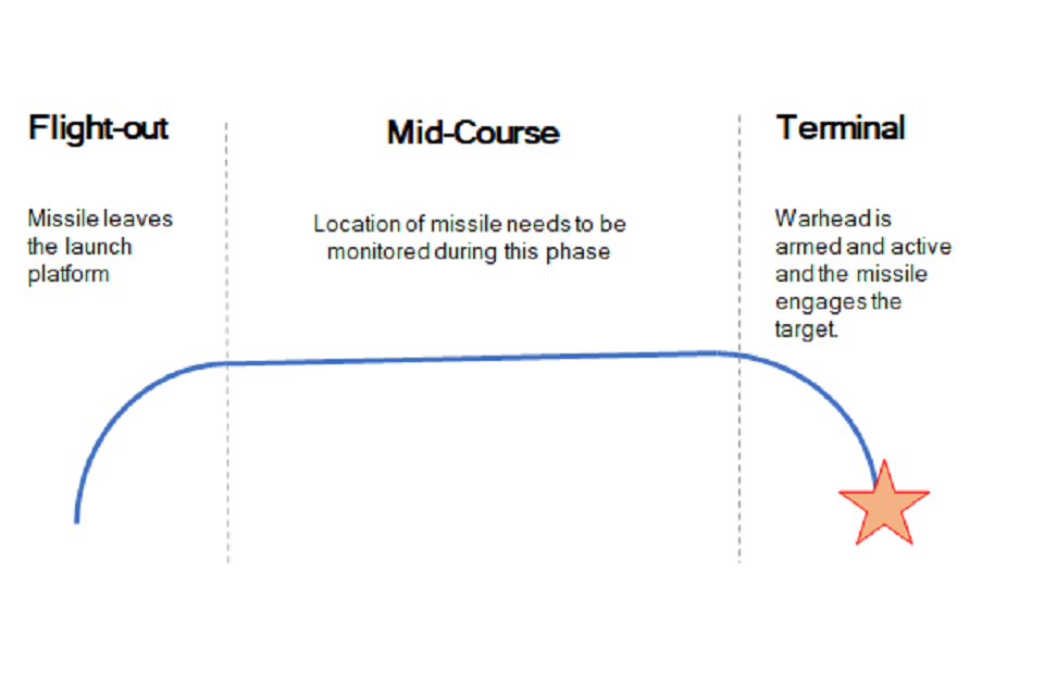
Specifically, UK Defence Equipment and Support (DE&S) and the Defence and Security Accelerator (DASA) want to understand the range of technologies used for commercial positioning and navigation systems. Its main area of interest is to know the location of the weapon during the mid-course phase of deployment, as shown in the figure below, with an accuracy of ±5 meters. Technology guidance to the final target is not part of the scope.
Project focus is location of the weapon during the mid-course phase of deployment with an accuracy of ±5 meters. (Image: UK Defence)
With GNSS vulnerable to jamming and spoofing, the exploration is interested in supporting navigation and positioning technologies, such as:
Terrain contour matching (TERCOM): uses a radar altimeter and a digital terrain elevation database.
Digital scene matching (DSMAC): matches an onboard image to an imagery database.
Inertial navigation systems (INS) or inertial measurement units (IMU): rely on accurate measurements of velocity and time to calculate position.
The market exploration is part of a larger Technology Demonstration Program. The defense agencies recently ran an Innovation Focus Area looking at quantum navigation systems, and selected several proposals for funding.
Quantum technology is not specifically out of scope for this exploration, but the agencies are specifically looking for technologies that could be developed to a testing and trialling prototype within the next three years.
Registration has now opened for the Applanix User Group Meeting and Conference, focused on Air and Land solutions, taking place in Fremont, California, Sept. 20-22. Discounted early bird prices will be available until May 22. The conference is also currently accepting speaker proposals.
This meeting will give you the opportunity to hear the latest news from Applanix, take in-depth product training, meet with product and customer support experts, and network with other industry leaders from around the world.
The conference will take place over three days and will have four main goals:
• Deliver an information-filled training experience on all of our software, as well as the APX series of boards, POS products, and the latest developments in the Autonomy field
• Present the new Land Mobile Mapping line of OEM and plug-and-play products
• Give customers and partners an opportunity to share their most recent projects and experiences
• Provide networking opportunities
To register and purchase tickets for the conference or to submit a proposal, visit Applanix’s website.
Canada is leveraging advanced surveillance capabilities to enhance safety and efficiency by implementing a new mandate that will require aircraft operators flying in certain domestic airspace to meet Automatic Dependent Surveillance – Broadcast (ADS-B) Out performance requirements.
ADS-B uses GNSS technology to calculate an airplane’s precise location, speed and direction. This information is transmitted twice per second, providing greater situational awareness for air traffic controllers. It also provides increased flexibility to accommodate airline and customer preferred routes.
The mandate will take effect in Class A and B Canadian airspace above 12,500 feet on Feb. 23, 2023.
“ADS-B is a foundational building block for our future airspace and operations,” said Raymond G. Bohn, president and CEO of Nav Canada. “The Canadian equipage mandate — when combined with Nav Canada’s space-based surveillance capabilities — will enhance safety and service.”
“The aviation sector plays an essential role in connecting Canadians to each other and the world,” said the Honourable Omar Alghabra, Minister of Transport. “We welcome advancements and innovation that enhance the safety and environmental sustainability of our transportation networks and supply chains.”
The equipage requirements of Canada’s ADS-B mandate are in line with a growing number of other countries in the world, and the adoption of satellite-based surveillance technology ensures long-term alignment with the global aviation system.
Space-based ADS-B is already being used and delivering safety and efficiency benefits to suitably equipped aircraft over Hudson Bay, the North Atlantic and in domestic airspace above 29,000 feet in Canada. In December 2021, Nav Canada began providing service to appropriately equipped aircraft below 29,000 feet in the Montreal Flight Information Region and plans to expand to the Edmonton and Winnipeg Flight Information Regions later this year, prior to the mandate going into effect in 2023.
Future implementation of a mandate in areas within Class C, D and E will leverage a phased approach to help achieve the maximum benefits of a performance-based mandate for Canadian airspace. Aircraft operators and owners will have adequate time to meet the equipage requirements to use space-based ADS-B technology across the country. Implementation in these classes of airspace, to occur no sooner than 2026, will be determined pending further assessment.
About the ADS-B mandate
To meet the ADS-B Out mandate, aircraft will be required to:
Be equipped with an appropriate transponder with ADS-B Out capabilities and performance with the applicable standard of Radio Technical Commission for Aeronautics (RTCA) DO-260B, “Minimum Operational Performance Standards” or newer.
Have antenna capability for broadcast toward space-based ADS-B receivers emitting 1090 MHz extended squitter. This requirement can be met either through antenna diversity (the use of a top and a bottom antenna) or with a single antenna capable of transmitting both toward the ground and up toward satellites.
The Japan Aerospace Exploration Agency (JAXA) has selected a contractor for a study of positioning in space after an open-call competition.The study, part of “Development of Positioning and Communication Technology for Monthly Activities,” will consider possible lunar positioning satellite systems and ultra-long-range communication systems between the Moon and the Earth.
Artist’s rendering: NASA
JAXA is managing the project, with Ark Edge Space Co. Ltd. serving as the outsourcer for a consortium of companies and academia. Consortium members include Ark Edge Space, AAI GNSS Engineer Office, Kiyohara Optical Co. Ltd., KDDI Corporation, KDDI Research Institute, the University of Tokyo Graduate School of Engineering and Mitsubishi Precision Co. Ltd.
From Jan.1 to March 25, the consortium is studying a comprehensive architecture for positioning and communication systems that will be the basis of lunar exploration, including a lunar positioning satellite system that takes into account the ultra-long distance between the Moon and the Earth.
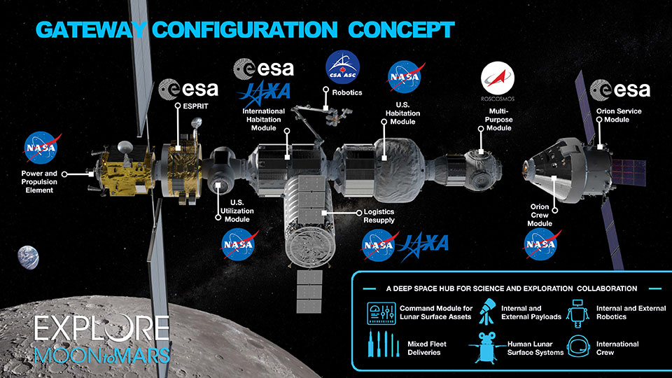
Map of the modules for the proposed Lunar Orbital Platform-Gateway station, to operate on the Moon and obtain construction within the 2020s. (Image: NASA)
Activities related to international lunar exploration and development are increasing, including the United States-led international Artemis Program, which plans for a manned lunar landing in 2025 and a manned Mars landing in the 2030s.
The Japanese government is participating in Artemis, joining other countries to build a lunar orbiting base named “Gateway.” Gateway will serve as a way station to support exploration of the lunar surface.
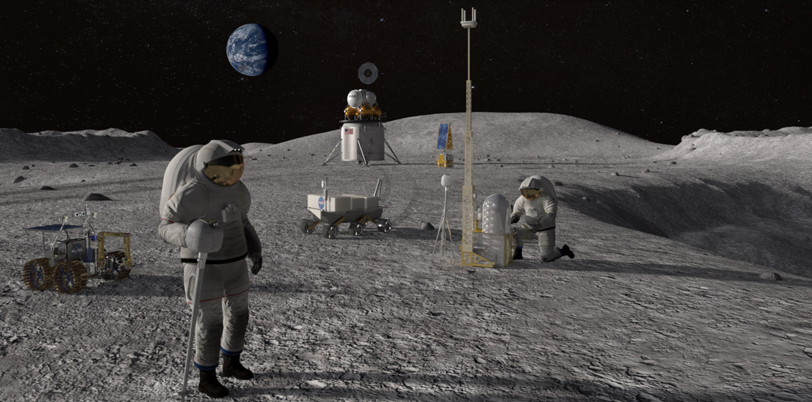
Feature image: Artist’s conceptualization of Artemis astronauts using lunar positioning and communications on the Moon. (Image: NASA/Resse Patillo)
Emcore Corporation has entered into a definitive agreement to acquire the assets and liabilities of the L3Harris Space and Navigation business for approximately $5 million in an all-cash transaction.
“L3Harris Space and Navigation designs and builds some of the most accurate navigation products in the world,” said Jeff Rittichier, president and CEO of Emcore. “This acquisition expands our fiber-optic gyroscope (FOG) product portfolio into the strategic grade and space-qualified markets. We will also gain a technical team with a sterling track record of development and production of high-performance FOGs, ring laser gyros (RLGs) and reaction wheels.
“This acquisition further solidifies Emcore’s position as one of the largest independent inertial navigation providers in the industry. This is an excellent fit strategically for Emcore, bringing space and navigation’s strong brand, inertial technology and important program wins. It also expands Emcore’s market reach into launch vehicle and space satellite markets, both of which are seeing significant growth,” Rittichier added.
“The L3Harris Space and Navigation team will provide Emcore with the capability to accelerate expansion into a true navigation-grade FOG business with superior performance and accuracy compared to competitors,” said Albert Lu, senior vice president and general manager, Aerospace and Defense for Emcore. “Combining this business into Emcore will allow us to provide customers with an expanded product suite that serves a broader range of requirements across both the tactical and navigation grade segments of the market.”
Highlights of the transaction are as follows:
Expands Emcore’s inertial navigation product portfolio and addressable market, accelerating growth and contributing additional revenue.
Includes master supply agreements (MSAs) for the BoRG (Booster Rate Gyro) and TAIMU (Tri-Axial Inertial Measurement Unit) launch vehicle programs and creates partnership opportunities with L3Harris to expand mutual business.
Adds Emcore as a preferred supplier to L3Harris divisions for future business opportunities.
Adds a complete set of capabilities to design and test for space applications:
shock, vibration and thermal-shock measurement equipment
x-ray capability and vacuum chambers.
Includes a large number of rate tables that can serve multiple product applications.
Is expected to create material operating synergies in engineering, manufacturing and sales.
Is expected to be non-GAAP EPS accretive.
Through the transaction, Emcore will acquire all the intellectual property and outstanding assets and liabilities of the L3Harris Space and Navigation business, including the 110,000-square-foot leased production facility in Budd Lake, New Jersey.
The consummation of the transaction is subject to customary closing conditions and is currently expected to close in the quarter ending June 30, 2022.
The United Kingdom’s Defence and Security Accelerator (DASA) has launched a new Market Exploration called Alternative Navigation for Weapon Systems, which aims to explore alternatives to GNSS for military navigation.
The Market Exploration is being run on behalf of Defence Equipment and Support (DE&S) and seeks to understand the range of technologies used for commercial positioning and navigation systems.
GNSS such as GPS and Galileo are widely used for commercial and military positioning and navigation, but these systems are vulnerable to jamming and spoofing. DASA wants to explore alternative navigation technologies that could be developed and trialed within the next three years.
The potential system should:
be developed to an operational level in either a civilian or on military application
have the potential to be further developed to meet military specifications.
have sufficient accuracy to monitor position during deployment to within 5 meters.
The agency is particularly interested in innovations from non-traditional defence suppliers and has a dedicated team of DASA Innovation Partners who can discuss proposals with submitters.
Orolia Defense & Security, provider of software-defined simulation solutions for navigation warfare, will supply a BroadSim Wavefront to the U.S. Air Force Guided Weapons Evaluation Facility (GWEF). BroadSim Wavefront is an innovative, Skydel-powered advanced GNSS simulator.
The BroadSim Wavefront simulator from Orolia Defense & Security. (Photo: Orolia)
The GWEF provides laboratory testing and simulation tools for developing precision-guided weapon technology, including a comprehensive scope of GPS plus inertial navigation systems (INS) and integrated components such as sensors, signals of opportunity and controlled reception pattern antennas (CRPAs). CRPAs are fundamental in many platforms due to their enhanced protection against electronic attacks in NAVWAR environments.
The Broadsim Wavefront simulator will be integrated into a test environment for networked, collaborative and autonomous weapon systems being developed under the Golden Horde program. Golden Horde is one of four Air Force Vanguard programs designed to rapidly advance emerging weapons systems and warfighting concepts through prototype and experimentation.
Of the several capabilities the GWEF required, features such as low-latency hardware-in-the-loop, automated calibration, and the flexibility to quickly integrate future signals and sensors were the most critical and serve as a key reason Orolia’s BroadSim Wavefront was selected. The system will also be capable of testing eight-element CRPA systems, eight simultaneous fixed radiation pattern antenna systems (FRPA), or a combination of CRPA and FRPA systems.
“When designing BroadSim Wavefront, we re-imagined every aspect for the user,” said Tyler Hohman, director of products for Orolia Defense & Security. “Though the GWEF unit contains eight nodes (corresponding to each antenna element), it can be scaled from four to 16 antenna elements. One of the greatest advancements is our continuous phase monitoring and compensation technique. It automatically monitors, aligns and adjusts the phase of each RF output continuously throughout the duration of a scenario.”
“Gone are the days of re-calibrating each frequency on your system, limiting your scenario duration or re-calibration every time you power cycle your system,” Hohman said. “Simply turn the system on, start the scenario, and your Wavefront system phase aligns and remains aligned for the entirety of the test.”
Leveraging the Skydel Simulation Engine, BroadSim Wavefront also supports high-dynamics, MNSA M-code, alternative RF navigation, open-source inertial measurement unit (IMU) plug-ins and a 1000-Hz iteration update rate.
“Because of the software-defined architecture, many upgrades don’t require additional hardware, which has been a crucial advantage for customers who are already using this solution,” Hohman said.
On Jan. 15, Hunga-Tonga-Hunga-Ha’apai, an uninhabited volcanic island on the Tongan archipelago in the South Pacific Ocean, erupted with spectacular force, churning ocean waters halfway across the globe.
GNSS engineers also detected its effects hundreds of miles above, in the ionosphere. The GNSS community is now moving from such after-the-fact detection to real-time monitoring using NASA’s Global Differential GPS (GDGPS) system, according to a team with the Tracking Systems and Application Section at NASA’s Jet Propulsion Laboratory (JPL) in Southern California.
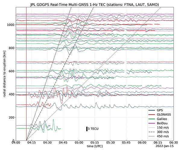
“We monitored, in real time, four GNSS satellite constellations from numerous stations around the world using the GDGPS network. In particular, the three stations closest to the volcano, in Samoa, Fiji and Tahiti,” said postdoctoral associate Leo Martire. “We could see extremely high and strong signals in the ionosphere, which is very unusual. As a function of radial distance from the eruption, the first detected ionospheric perturbation likely originated directly from the explosion. Then we see patterns propagating at increasing distances at different radial propagation speeds.”
Monitoring such events adds information to the catalog of signals from natural hazards, pointed out Siddharth Krishnamoorthy, a research technologist who manages JPL’s GUARDIAN near-real-time tsunami warning system, currently under development. “That is useful because, in the future, if you want to be able to spot natural hazards and issue alerts, you need to know what the signal looks like. There have been reports of a tsunami in Tonga due to this event, so we will look at potential tsunami-induced signatures in the ionosphere. We are trying to get to a place where we pick up a signal like this and we are able to say, ‘This is a tsunami propagating at this speed and in this direction.’”
Chart: Jet Propulsion Laboratory
Before being detected in the ionosphere, signals from natural hazards must travel all the way from the surface. For tsunamis, this usually takes more than 10 to 20 minutes, but the volcanic eruption only took a couple of minutes to reach the ionosphere because it shot straight up. “We do not know yet, based on observations, how exactly different events on the surface caused by natural hazards couple with the atmosphere,” said research technologist Panagiotis Vergados. “Every event is unique in its spectral properties.”
The event did not affect the quality of GDGPS’s GNSS positions or orbits, because dual-frequency measurements remove significant ionospheric effects. “Instead of looking at the direct effects on the position of our available reference stations, which is what our traditional real-time monitoring does and which was basically negligible, imagine the links from each of those stations to a dozen or more satellites,” said Larry Romans, GDGPS chief technologist. “Every time one of those many links pierces the ionosphere, we can monitor that signal for ripples as waves go by. So, this is an incredibly powerful method for seeing disturbances, just in terms of the density of data. It is very complementary to position-based natural-hazards monitoring because the data is much richer.”
In addition to volcanoes and tsunamis, several other natural events, such as earthquakes and very large thunderstorms, also produce these effects. “These natural forcings cause large-scale, low-frequency pressure perturbations that tend to travel up and be visible in the ionosphere,” Krishnamoorthy said. “There are also perturbations of the ionosphere due to events from outside the Earth, such as solar flares or bolide impacts.”
Many of these perturbations start from the troposphere, which ranges between 10 km and 15 km in altitude — including hurricanes, which overshoot gravity waves all the way to the ionosphere, and thermal tides that have been observed to go all the way up to 600 km, said Vergados. “There are also geomagnetic storms and sub-storms that, during electron precipitation, can change the ionization of the ionosphere. So, the coupling can happen from either below or above or simultaneously, and then the effect can be dramatically enhanced.”
Most of the perturbations that come from below are of a pressure nature — that is, they start out as mechanical waves — while most of those that come from above are electromagnetic. “Aside from nuclear explosions, very large chemical ones, such as the 2020 Beirut explosion, also cause a signature on the ionosphere because they create very large pressure waves,” Krishnamoorthy said.
Photo: Tonga Meteorological Services, Government of Tonga
A positioning service energizes large pipeline surveying projects, saves time, and becomes a field crew favorite
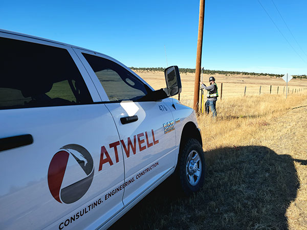
For projects spanning large areas, a large engineering and construction firm discovered that a precise point positioning (PPP) service — Trimble’s CenterPoint RTX — could solve the challenge of receiving high-precision GNSS in remote areas.
Atwell Group LLC is a national consulting, engineering and construction services firm with 33 offices throughout the country and more than 1,000 team members. The company delivers a broad range of strategic and creative solutions to clients in three core markets: oil and gas, power and energy, and real estate and land development.
Atwell provides comprehensive turnkey services, including land and right-of-way support, engineering, land surveying, environmental compliance and permitting, and project and program management.
Photo: Trimble
Pipeline construction
Atwell’s introduction to PPP and Trimble’s CenterPoint RTX took place during two large-scale linear pipeline projects within remote areas. Atwell has substantial experience with projects of this scale, but the remoteness of some of the projects’ sections was proving to be a challenge. While they could expect to rely on base or network correction methods for most projects, Atwell needed to seek other correction alternatives — and up their efficiency for the long-corridor projects.
With the CenterPoint RTX service at hand, Atwell performed construction staking and as-built surveys for a 50-mile pipeline. The project spanned a five-month period, with an hour or more of time saved each day using the service.
Crews noticed an additional benefit: rapid response time. On any given day, there could be project managers, right-of-way agents, or inspectors on site, asking for additional survey data.
“Inspectors and others started to notice how fast our crews could jump from one place to another and get the shots they requested, without having to do any base setups,” said Jason Jung, project manager with Atwell.
“The speed at which our crews can get up and running with RTX is awesome.” — Jason Jung, 3D laser scanning projects manager, Atwell
Because of the range limits of base radios, the crews might have to do multiple setups of a conventional real-time kinematic (RTK) base each day. RTX removed this hindrance, saving the crews time by not having to use temporary RTK bases, which entails driving to base reference points, setup and teardown, and downtime from malfunctioning equipment and battery issues.
“RTX completely freed us from the time and hassle of base setups,” Jung said. “You turn it on, and it’s ready to go before you’ve had time to take a sip of coffee. And once our crews got used to it and gained confidence in the results, they have really loved this solution.”
Photo: Trimble
Scanning a pipeline
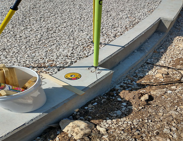
Atwell recently used CenterPoint RTX on a 135-mile large-diameter pipeline project that included 19 facilities along the route. Atwell provided as-built services related to the facilities using a Trimble X7 scanner.
The data captured was used to generate spatially correct site models that included the material traceability necessary to comply with Pipeline and Hazardous Materials Safety Administration (PHMSA) regulations. Crews used RTX to georeference point clouds from the scanner to provide the accuracy needed to comply with industry regulations. Each site was referenced with permanent monuments or scribes that tied into the master control system.
Crews also used the RTX service to establish hard checkpoints to meet Atwell’s strenuous quality-control requirements for ground targets, such as those used in UAS control work. To do the daily “in and out” check shots, they used the free BenchMap app to locate nearby survey control marks from the National Geodetic Survey database. Most checks were sub-0.08’.
The time saved in not having to change base positions, as well as setup and breakdown, were significant time savers along this lengthy project. The precisely registered scans helped speed up PHMSA required inspections and audits, and construction change management field operations.
A crew favorite
Atwell’s crews use Trimble R10 receivers and Trimble Access running on TSC7 controllers, but Jung noted that they have recently upgraded to some R12i GNSS receivers, “and they are already earning their keep.” He expects to realize even more benefits from RTX coupled with the advanced multi-constellation capabilities of the Trimble ProPoint RTK engine in the R12i.
RTX has not only become a crew favorite, it is fast becoming a go-to solution for many Atwell projects.
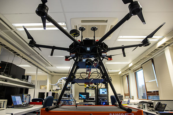
The Navigation Laboratory of the European Space Agency (ESA) has acquired an unmanned aerial vehicle (UAV) that can carry different types of satellite navigation receivers to collect data for follow-on analysis.
The NavLab, based at ESA’s ESTEC technical centre in Noordwijk, the Netherlands, is focused on the testing, analysis and characterization of navigation systems for both ESA and external customers.
With UAVs representing a rapidly expanding user base, the new UAV is a timely addition to the NavLab’s suite of platforms for testing GNSS technologies and techniques, ESA said. Other tools include static, mobile and pedestrian platforms and a pair of test vans.
Along with receivers and antennas, the UAV can host radio-frequency spectrum samplers and support equipment such as inertial sensors and stereo cameras, allowing the assessment of performance in specific dynamics and environments related to UAV applications, such as approach, landing, flying beside buildings or indoors.
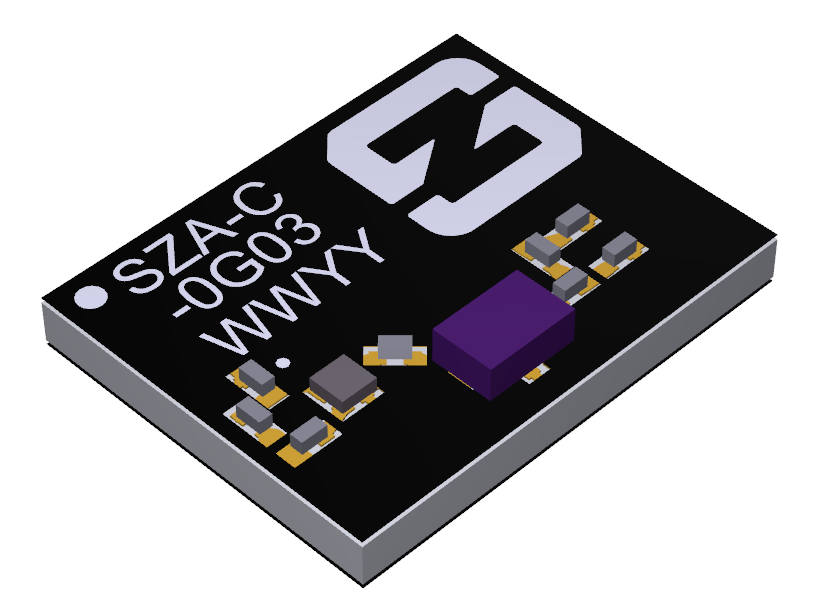
Antenna company Synzen Precision Technology has teamed up with Next Big Thing AG (NBT) to produce the sensor-based LTE-M/NB-IoT development platform Prometheus, which promises fast cellular internet of things (IoT) prototyping.
The PROXIMA GNSS antenna will be part of the Prometheus platform. (Photo: Synzen Precision Technology)
Prometheus is an IoT sensor-based development platform designed to simplify prototyping and speed time to market for developers of IoT and cloud-based solutions. The latest platform showcases Synzen’s expertise in GNSS and LTE 4G antenna solutions when combined with the Nordic nRF9160 module.
The building blocks enabling the mobility and IoT revolution are “always-on” connected 4G cellular and accurate and reliable GNSS solutions, regardless of the operating environment, Synzen said. Prometheus provides 4G connectivity combined with high-performance GNSS positioning solutions.
For the Prometheus platform, NBT chose the low-power FR4 active GNSS solution. “The selection of our latest PROXIMA low-power active solution in an FR4 package helped enable a fully certified solution optimized for low power consumption over the full industrial temperature range of –40 to +85 degrees centigrade,” said Chris Tomlin, Synzen technical director.
The PROXIMA GNSS SMD active antenna includes an amplifying front end to boost the signal as well as provide out-of-band filtering to prevent receiver saturation.
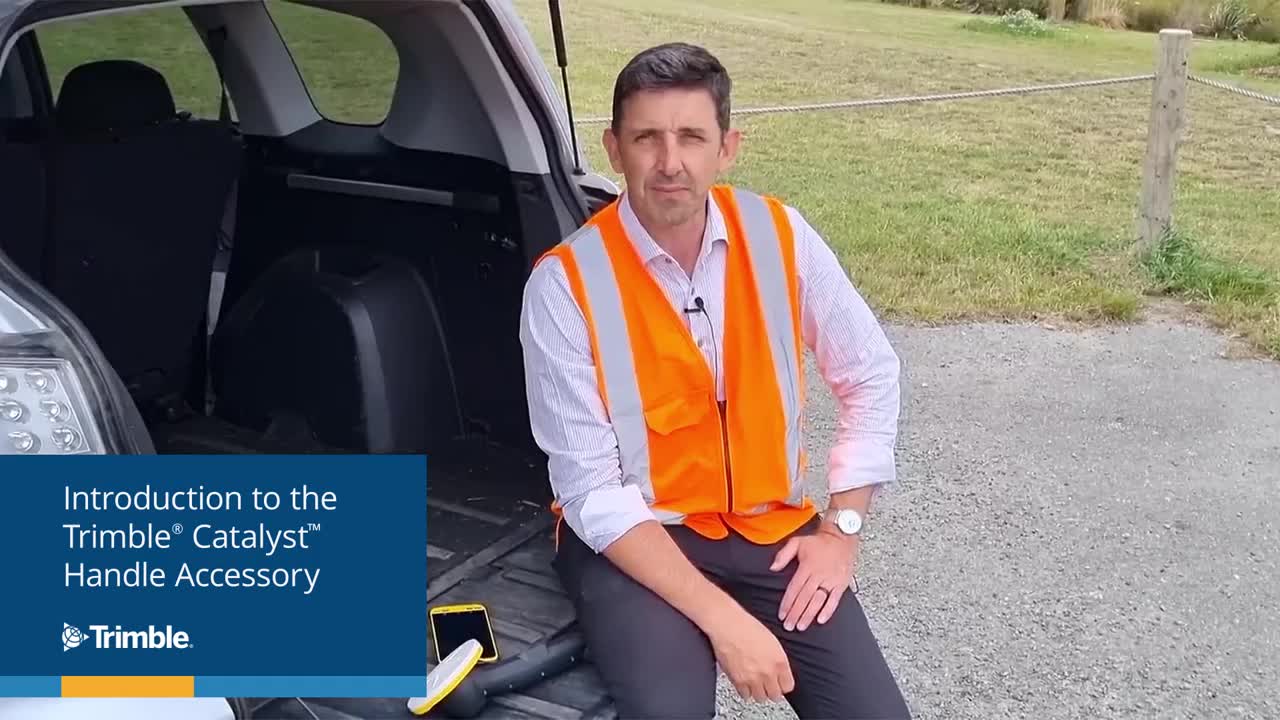
Trimble has introduced the Trimble Catalyst handle, which adds a new level of flexibility to accessing GNSS data. The lightweight, ergonomic handle provides a convenient way to carry Trimble’s Catalyst-enabled mapping and field data-collection workflows.
Users can:
choose their device, whether iOS or Android, which turns any smartphone or tablet into a Trimble-quality handheld positioning system
swap out a device at any time, whenever an upgrade is needed
adjust accuracy level as requirements change by switching the accuracy-based Catalyst subscription
affix a monopole when decimeter-level or better positions are crucial.