Category: Applications

  • NTS-3 mission progresses toward launch in 2023

    NTS-3 mission progresses toward launch in 2023

    The Navigation Technology Satellite-3 (NTS-3) program is making major strides in developing a new navigation spacecraft for in-space demonstration. The NTS-3 is scheduled to launch to geosynchronous orbit from Cape Canaveral in 2023.

    This summer, Northrop Grumman Corp. delivered the ESPAStar-D spacecraft bus to L3Harris Technologies of Palm Bay, Florida.

    “The transfer of the bus allows L3Harris to move forward building the NTS-3 spacecraft,” said 2nd Lt. Charles Schramka, the program’s deputy principal investigator. “L3Harris will perform tests and begin integrating the NTS-3 PNT payload onto the bus. Together the bus and payload will form the NTS-3 spacecraft.”

    Following L3Harris’s work, the Air Force Research Laboratory (AFRL) will test the bus with the NTS-3 ground control and user equipment segments, and will perform its own integrated testing on the overall NTS-3 system architecture.
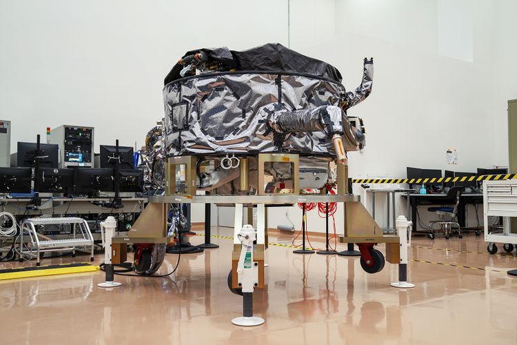
    Northrop Grumman has successfully delivered an ESPAStar-D spacecraft bus to L3Harris in support of the NTS-3 mission. (Photo: U.S. Air Force)
    Northrop Grumman has successfully delivered an ESPAStar-D spacecraft bus to L3Harris in support of the NTS-3 mission. (Photo: U.S. Air Force)

    NTS-3 in the Vanguard. In 2019, the U.S. Air Force designated NTS-3 as one of three Vanguard programs — priority initiatives to deliver new capabilities for national defense. The NTS-3 mission is to advance technologies to responsively mitigate interference to position, navigation and timing (PNT) capabilities, and increase system resiliency for GPS military, civil and commercial users.

    “This is the first time an ESPAStar bus has been built and delivered as a commercially available commodity,” said Arlen Biersgreen, NTS-3 program manager. “NTS-3 is using a unique acquisition model for the ESPAStar line that fully exercises the commercial nature of Northrop Grumman’s product line, in order to provide the bus to another defense contractor for payload integration using standard interfaces.”

    The ESPAStar-D bus, built in Northrop Grumman’s satellite manufacturing facility in Gilbert, Arizona, includes critical subsystems such as communications, power, attitude determination and control, in addition to configurable structures to mount payloads.

    The bus will “provide affordable, rapid access to space,” according to Northrop Grumman. Its configuration, using an Evolved Expendable Launch Vehicle (EELV) Secondary Payload Adapter (ESPA), allows multiple separate experimental payloads to be stacked together on one launch vehicle. AFRL developed the ESPA ring to transport space experiments, allowing for lower cost and more frequent trips to space for government and industry users.

    Besides the bus delivery, there are other advances in the program.

    GNSSTA receiver. In June, AFRL took delivery of an experimental receiver — GNSS Test Architecture (GNSSTA). The receiver was developed by the AFRL unit the Sensors Directorate, located at Wright-Patterson Air Force Base in Ohio, and Mitre Corporation. GNSSTA is a reprogrammable software-defined signal receiver that will allow the Air Force to receive both legacy GPS and advanced signals generated by NTS-3.

    AFRL will continue its integration efforts through 2022 to ensure all parts are working together for the fall of 2023 NTS-3 launch.

    “With the delivery of the bus we are entering into the next phase of payload integration,” Biersgreen said. “These recent breakthroughs allow the program to continue to move forward and prepare for launch of the first U.S. integrated satellite navigation experiment in over 45 years.”


    Artist’s concept for NTS-3 in geostationary orbit. (Artist's concept: 2d Lt Jacob Lutz, AFRL/RV)
    Artist’s concept for NTS-3 in geostationary orbit. (Artist’s concept: 2d Lt. Jacob Lutz, AFRL)
  • SMC commander Lt. Gen. Thompson retires

    SMC commander Lt. Gen. Thompson retires

    Lt. Gen. John F. Thompson
    Lt. Gen. John F. Thompson

    Lt. Gen. John F. Thompson, commander of the Space and Missile Systems Center (SMC), will retire Aug. 1. A ceremony celebrating his career and achievements took place July 27 at Los Angeles Air Force Base, California, where SMC is based.

    Thompson, who is the longest serving three-star commander for SMC, retires after a 36-year career with the U.S. Air Force, having served in various roles leading defense acquisition programs, strategic systems and lifecycle management.

    Brig. Gen. D. Jason Cothern, current vice commander of SMC, will serve as the SMC commander while the center awaits a confirmation of a three-star general officer.

    SMC includes the positioning, navigation and timing (PNT) mission, in which professionals acquire, deliver and sustain reliable GPS capabilities to America’s warfighters, allies and civil users.

    “Lt. Gen. Thompson’s exemplary career has made the nation safer, stronger and better secured against an increasingly contested space environment, and earned the well-deserved opportunity to enjoy this next chapter in his life,” stated a press release from SMC.

    As the commander of SMC, he led more than 6,300 military, government service and contract employees nationwide, and oversaw an annual budget of $9 billion, which accounts for 85 percent of the nation’s space budget.

    In the past 18 months, Lt. Gen. Thompson tirelessly led the groundwork for the stand-up of the U.S. Space Force’s newest Field Command, Space Systems Command, which will lead the Force in the development, delivery and acquisition of innovative space warfighting capabilities.

    Having completed his four-year tour as the SMC commander, his retirement will not affect the timeline of the SSC stand-up — a complex process requiring activities and approvals at the highest levels before implementation.

  • U.S. Army Sentinel A4 radar program receives Orolia M-code solution

    U.S. Army Sentinel A4 radar program receives Orolia M-code solution

    Orolia Defense & Security delivers M-code-enabled timing and synchronization to Lockheed Martin

    In September 2019, Lockheed Martin was awarded a contract to develop the U.S. Army’s Sentinel A4 radar system, an air and missile defense radar that will provide improved capability against dynamic threats.

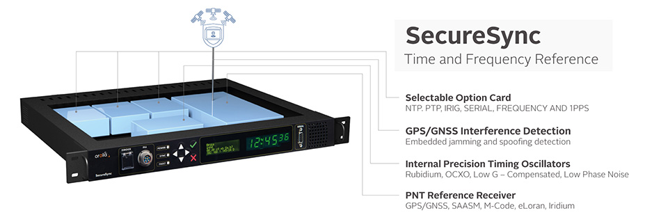
    The following November, Orolia Defense & Security announced the availability of M-code military GPS receivers in its flagship SecureSync — the first time server approved by the Defense Information Systems Agency.

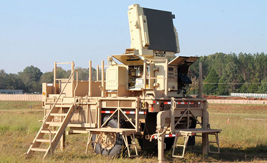
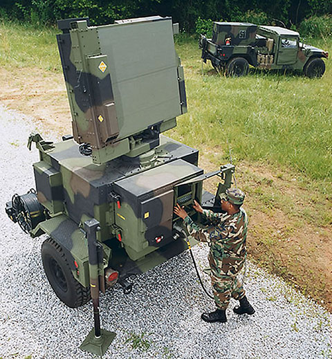
    Orolia is supplying SecureSync units for Lockheed Martin's Sentinel A4 radar. (Photo U.S. Army)
    Orolia is supplying SecureSync units for Lockheed Martin’s Sentinel A4 radar. (Photo U.S. Army)

    This May, Orolia delivered a shipment of M-code-enabled SecureSync mission timing and synchronization units to Lockheed Martin, marking a key milestone for the Army program. SecureSync with M-code provides enhanced resilient positioning, navigation and timing (PNT) capabilities and improved resistance to existing and emerging GPS threats, such as jamming and spoofing.

    Lockheed Martin selected Orolia’s SecureSync M-code as the A4 system’s resilient time and frequency reference solution in part due to its modular, open architecture – the same characteristics that are the cornerstone of the radar’s design – making integration a simple process and ensuring future upgrades.

    “As a trusted Lockheed Martin partner, Orolia is proud to support the development of the Sentinel A4, which will be a key asset to our warfighters for decades to come,” said Hironori Sasaki, president of Orolia Defense & Security. “Making M-code available now in a readily configurable and scalable form factor is a critical step in advancing our forces out in the field, whether in the air or on the ground,” Sasaki added.

    The next-generation of U.S. military systems are fortified with M-code, and Orolia leads the industry in M-code solutions for navigation warfare (NAVWAR) environments.

    Orolia is supplying SecureSync units for Lockheed Martin's Sentinel A4 radar. (Photo U.S. Army)
    Orolia is supplying SecureSync units for Lockheed Martin’s Sentinel A4 radar. (Photo U.S. Army)
    Photo:
    Image: Orolia
  • Oceaneering and DDK Positioning enhance C-Nav positioning solutions’ offerings

    Oceaneering and DDK Positioning enhance C-Nav positioning solutions’ offerings

    Photo: arild lilleboe/iStock/Getty Images Plus/Getty Images
    Photo: arild lilleboe/iStock/Getty Images Plus/Getty Images

    Oceaneering International Inc. and DDK Positioning Limited have entered into an agreement for the provision of GNSS augmentation service and all associated software and hardware supporting Oceaneering’s C-Nav Positioning Solutions group offerings.

    Oceaneering provides engineered services and products primarily to the offshore energy industry. C-Nav uses precise point positioning corrections with worldwide accuracy of better than 5 cm horizontally and 15 cm vertically.

    DDK Positioning’s services are delivered through the Iridium satellite communications network coupled with hardware developed by partner Topcon. This pairing will enhance the ability of Oceaneering’s customers to precisely position their assets globally. The unified solution offers several benefits to Oceaneering’s positioning customers, such as two-way communication enabling machine control and feedback, and redundancy to cover potential signal losses.

    From launch, DDK Positioning will provide its MAX service to Oceaneering clients, which can achieve accuracy to less than 10 cm (2 sigma). The MAX service uses GPS, Galileo, and GLONASS constellations with further systems to be added within a year.

    “Significant advances have been made in communications infrastructure and satellite positioning technology over the last several years,” said Eric Smith, director of Survey Services at Oceaneering. “With this agreement, Oceaneering will be able to offer enhanced positioning technology allowing us to build on our strong industry track record while continuing to serve the positioning needs of our clients now and into the future.”

    “We are absolutely delighted to have signed an agreement with Oceaneering to provide our precise and reliable GNSS positioning solution to Oceaneering’s customers in the maritime energy industry,” said Kevin Gaffney, CEO at DDK Positioning. “This agreement demonstrates the need for an alternative GNSS augmentation service that increases the reach of services from pole to pole, with the added benefit of Iridium’s resilience and reliability.”

  • UrsaNav trials eLoran as GNSS backup with ADVA grandmaster clock

    UrsaNav trials eLoran as GNSS backup with ADVA grandmaster clock

    Successful eLoran field trial using ADVA’s OSA 5420 Series demonstrates same accuracy and stability as GPS with much-improved resilience

    UrsaNav and ADVA have conducted an enhanced long-range navigation (eLoran) field trial using UrsaNav’s eLoran receiver and ADVA’s Oscilloquartz grandmaster clock technology. The successful demonstration shows that eLoran offers a robust and reliable backup for GPS and other GNSS, and could be used to provide an assured position, navigation and timing (PNT) service.

    The trial follows U.S. PNT Executive Order 13905 aimed at strengthening national resilience through PNT services, including protecting critical infrastructure such as electrical power grid and communication networks from rising cyber threats. By harnessing ADVA’s flexible OSA 5420 series, designed with assured PNT (A-PNT) technology, UrsaNav has shown that eLoran can provide a new layer of protection and significantly boost timing resilience and security.

    “The success of this field trial demonstrates how eLoran, as part of ADVA’s assured PNT solution, can serve as a crucial backup for GPS,” said Charles Schue, CEO, UrsaNav. “We have shown how our technology enables ADVA’s grandmaster clock to receive UTC timing from the eLoran system for a period of several days with the same accuracy and stability as GPS. Of course, this capability is extensible to other GNSS as well. eLoran is far less vulnerable to unintentional jamming and spoofing disruptions or intentional attacks, thereby delivering nanosecond precision with even more resilience.”

    “By partnering with ADVA, we’ve been able to show that our eLoran receiver interoperates with the best network timing toolkit available,” Schue said. “The OSA 5420 Series is a great product — highly efficient and easy to operate. Together with ADVA, we’re paving the way for tomorrow’s more robust assured PNT synchronization architecture. Now that UrsaNav has demonstrated the power of our OSA 5420 Series to utilize eLoran in the event of outages, we have another very important tool to ensure the quality and availability of time-sensitive services.”

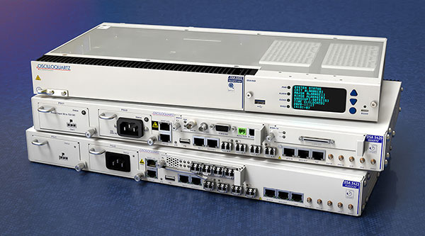
    UrsaNav’s latest trial used the OSA 5420 series grandmaster clock with built-in GNSS receiver. Timing stability from GPS was measured for several days. This was then replaced with eLoran for the same period with no loss of stability.

    The test was conducted indoors where GNSS signals are not usually available, potentially extending the availability of precise UTC timing to many more environments.

    “Commercially available GNSS jammers and spoofers are easy and cheap for attackers to acquire,” explained Nir Laufer, VP, product line management, Oscilloquartz, ADVA. “That’s part of the reason why we’re seeing a growing number of incidents across the world of blocked or misleading signals. If power utilities, enterprises, service providers and governments continue to rely on GNSS alone, it’s only a matter of time before the consequences become very serious. That’s why we’re committed to tackling GNSS vulnerabilities with advanced technologies like our ePRTC offering, cesium atomic clocks and our optical timing channel solution. Now that UrsaNav has demonstrated the power of our OSA 5420 series to utilize eLoran in the event of outages, we have another very important tool to ensure the quality and availability of time-sensitive services.”

    A demo showed how ADVA’s synchronization technology enables protection for critical infrastructure that needs ultra-reliable aPNT solutions. (Photo: Business Wire)
    The demo showed how ADVA’s synchronization technology enables protection for critical infrastructure that needs ultra-reliable aPNT solutions. (Photo: Business Wire)
  • Brazil approves SenseFly eBee X for BVLOS operations

    Brazil approves SenseFly eBee X for BVLOS operations

    Brazil’s Civil Aviation Authority approves  Flagship Fixed-wing Drone 

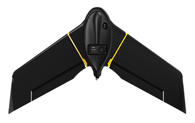
    The eBee X. (Photo: senseFly)
    The eBee X. (Photo: senseFly)

    The National Civil Aviation Agency (ANAC) of Brazil has approved beyond-visual-line-of-sight (BVLOS) flights using SenseFly‘s flagship eBee X fixed-wing drone.

    ANAC’s decision means that the senseFly eBee X is officially approved for use in future BVLOS missions carried out by Brazilian drone operators. The drone received approval by demonstrating the safety requirements of the ANAC RBAC-E 94 Regulation for Unmanned Aircraft, through detailed engineering analyses and in-depth flight testing. Sensefly worked in collaboration with drone engineering and consulting specialists AL Drones and geotechnology company Santiago & Cintra.

    Following the certification, senseFly eBee X operators in Brazil now only require a CAER (Special Airworthiness Certificate for RPA) waiver for the aircraft with Santiago & Cintra before flying BVLOS operations.

    “The commercial drone industry in Brazil has been growing at a phenomenal rate. and we’re excited that the senseFly eBee X is at the forefront of these regulatory developments,” said Pierre-Alain Marchand, regulatory compliance manager, senseFly. “BVLOS is becoming an important tool for operators as they start to explore the potential of more advanced drone operations, and we’re pleased that our technology continues to help define frameworks and legislation in the country. Historic approvals passed in recent years has shown us that Brazil is one of the countries to watch for drone commercialization, so continue to watch this space!”

    The authorization comes following approval of senseFly’s proprietary drone technology in 2017, where the use of drones for civil applications in Brazil were legislated as part of the RBAC-E94 regulation. SenseFly drones became the first and only in the country permitted to fly 400 feet in height with a 5 kilometer radius from a licensed pilot or observer, in contrast to previous VLOS operations that restricted use of drones to a 500-meter radius.

    “The authorization of senseFly’s eBee X for BVLOS operations is another step towards commercialization of the sector,” said André Arruda, co-founder of AL Drones. “After years of collective hard work and effort from all parties, this certification presents a real opportunity for operators in the future to expand their mapping operations and achieve a robust return-on-investment. We look forward to seeing what this means for BVLOS operations in Brazil in the coming years.”

    SenseFly’s eBee X fixed-wing drone is designed to suit a wide range of mapping jobs. At 1.6 kg (3.5 lbs.), eBee X is a lightweight, portable solution that is easy for a single person to operate. With an Endurance Extension option enabling a flight time of up to 90 minutes and single-flight coverage of up to 500 ha at 122 m (1,236 A at 400 ft.), the eBee X drone that offers users the high precision of on-demand RTK/PPK for achieving absolute accuracy down to 1.5 cm (0.6 in) without ground control points. This capability makes the eBee X suitable for BVLOS operations such as long corridor mapping missions for utility companies, expansive crop scouting in agriculture and by enterprise customers who desire a robust and professional drone fleet.

  • STMicroelectronics joins Startup Autobahn for auto innovation

    STMicroelectronics joins Startup Autobahn for auto innovation

    Autobahn program connects new companies with major brands for investment and development, ST is first semiconductor manufacturer to become Anchor Partner

    STMicroelectronics logoSTMicroelectronics, a global semiconductor company, has become an Anchor Partner of Startup Autobahn, which is powering innovation in the automotive sector by introducing selected dynamic new companies to established technology corporations.

    Startup Autobahn is based in Stuttgart, Germany. It was created by and is managed by Plug and Play, a Silicon Valley accelerator and investor that historically has introduced more than 35,000 startups to more than 400 corporations.

    Anchor Partners in Startup Autobahn include major car brands and vendors of diverse automotive technologies. ST’s support, with its strategic emphasis on smart mobility, boosts opportunities for new companies with innovative ideas for electrification, e-mobility and smart, connected driving to take part in the program.

    “We’re extremely pleased to welcome STMicroelectronics to our platform as a new strategic partner,” said Sascha Karimpour, managing director of Plug and Play Germany. “This partnership fits perfectly into our existing ecosystem, covering the automotive value chain. The semiconductor industry is enabling powerful innovations in automotive technology and will play a major role as software and IT become increasingly important in the car of the future.”

    Startup Autobahn organizes events throughout the year to bring corporate partners and selected startups together. The diverse platforms include deep-dive presentations, one-to-one introductions, cross-collaboration days, and private meetings between partners and shortlisted startups. Twice-yearly expos showcase the results of collaborations, combined with keynote speeches and presentations from various industry leaders and invited guests.

    The program has already successfully connected startups with established brands to activate powerful new concepts in areas such as battery charging, supply-chain and materials management, smart mobility, efficient manufacturing, recycling and enterprise CO2 reduction.

  • Deployment-ready lidar system Voyage launched

    Deployment-ready lidar system Voyage launched

    Image: Seoul Robotics
    Image: Seoul Robotics

    Seoul Robotics has launched Voyage, a plug-and-play lidar perception system. The all-in-one deployment kit is equipped with the company’s proprietary software SENSR2, lidar sensors and a computer.

    Seoul Robotics is a 3D computer vision company using artificial intelligence (AI) and machine learning for intelligent robotic perception systems. The company’s sensor-agnostic perception software is deployed by BMW, Mercedes-Benz, the Chattanooga Department of Transportation and Emart, among others.

    Seoul Robotics provides companies, institutions and governments with the software behind the sensor that enables its use in markets such as retail, smart cities and security. Voyage is designed to help organizations and communities increase efficiencies and improve safety through a cost-effective, customizable system.

    The lidar market, which is on track to reach more than $3 billion by 2025, has become crowded over the past several years as the technology became synonymous with autonomous vehicles. The marketplace is flooded with companies producing sensors to fuel the demand of this industry, but most sensors on the market are sold without any intelligence, leaving companies to develop software in-house, which significantly increases the time and cost of deployment.

    With Voyage, organizations are not obligated to purchase a particular sensor if it is not a fit for the solution they are deploying. Customers don’t have to worry about changing software when they change or upgrade their sensors — Voyage is a non-proprietary solution that breaks down the barriers to entry and allows for quick access to 3D vision, according to Seoul Robotics.

    “First and foremost, lidar sensors do not work without sophisticated perception software. The lidar industry is investing billions of dollars on sensors without even considering the software needed to interpret the data into actionable solutions,” said HanBin Lee, CEO of Seoul Robotics. “Voyage combines analytics and sensors to bring tangible solutions to market much faster.”

    Voyage provides highly accurate object detection, tracking and classification capabilities to enable a wide range of applications for smart cities, intelligent transportation systems, retail analytics, crowd monitoring and security. It fuses three cutting-edge technologies:

    • 3D lidar sensing powered by Seoul Robotics’ proprietary software SENSR2
    • Edge computing for minimum data burden and ease of integration
    • Built-in sophisticated perception software for instantaneous analytics

    Voyage provides centimeter-accurate 3D object detection, tracking, and classification in addition to volumetric profiling and motion prediction capabilities, regardless of lighting conditions, and can collect and process data from up to four sensors for seamless insights across the sensor coverage zones. As Voyage does not capture, show or store any biometric and otherwise identifying data, it aims to maximize the protection of people’s privacy when installed as part of various smart cities and security systems.

  • Trimble boosts RTX correction services for geospatial users

    Trimble boosts RTX correction services for geospatial users

    GNSS signal convergence means significant time savings for surveyors

    Photo: Trimble
    Photo: Trimble

    Trimble has announced enhancements to its Trimble RTX correction services, tailored to meet the evolving needs of geospatial professionals and part of an ongoing strategy to deliver high-accuracy correction services to users worldwide.

    Enhancements are designed to reduce convergence times, provide more reliable and robust signals, and make the workflow for surveyors easier. The enhancements further enable geospatial professionals to untether from the cost and complexities of GNSS base stations and complete fieldwork faster.

    Surveyors in many regions worldwide can now spend less time in the field with CenterPoint RTX correction service, converging in typically three minutes compared with up to 15 minutes in the past. The breakthrough convergence-time reduction is available on Trimble GNSS receivers with ProPoint technology and will benefit land surveyors working around the globe by enabling them to start surveying faster.

    In addition, CenterPoint RTX now supports the BeiDou III (BDS-III) constellation, which contributes to convergence time improvements. Support for BDS-III and convergence time improvements is available globally via IP/cellular and regionally via satellite delivery. Convergence times for the CenterPoint RTX Fast regions remain unchanged at less than one minute. CenterPoint RTX Fast coverage is available coast-to-coast in the U.S. and Western Europe.

    Geospatial professionals will be able to work more reliably in challenging GNSS environments, such as urban multipath or under tree canopy, due to the addition of BDS III and GPS III satellite signals into the Trimble RTX solution. Even as GNSS satellites are retired and new ones become operational, Trimble RTX will consistently track and deliver robust and reliable corrections.

    Using a Trimble receiver with ProPoint technology with Trimble Access field software and CenterPoint RTX correction service, surveyors will benefit from a streamlined workflow that simplifies how they work in their local coordinate systems. Surveyors can collect data using CenterPoint RTX correction service without the need for a site calibration or an offset.

    “Our teams collaborate to continually improve the Trimble RTX-based real-time correction services integration with our geospatial solutions,” said Ron Bisio, senior vice president of Trimble Geospatial. “Surveyors worldwide rely on Trimble to develop products and services that help them get their work done quicker and easier, and this Trimble RTX update is another example of how we continue to deliver surveyors the tools they need to do their jobs even more efficiently.”

    “We are celebrating 10 years of providing Trimble RTX-based correction services and each year our services outperform the year before,” said Lisa Wetherbee, general manager of Trimble Advanced Positioning. “We continue to enhance the performance and overall customer experience to help geospatial professionals increase their productivity and provide them peace of mind that our services and people will be there for them around the clock.”

    Trimble RTX subscriptions for Trimble RTX-compatible GNSS receivers are available through Trimble’s Authorized Business Partners or Trimble’s online store.

  • Swift Navigation and KDDI partner to expand precise positioning

    Swift Navigation and KDDI partner to expand precise positioning

    Swift Navigation logoSwift Navigation is partnering with Tokyo-based KDDI Corporation, an international telecommunications company, to help bring Swift’s precise positioning technology to the Japan market. KDDI will also be a key partner in the global expansion of Skylark precise positioning service, which is now available across the continental United States and Europe in partnership with Deutsche Telekom.

    Traditionally, precision GNSS corrections were provided using real-time kinematic (RTK) techniques, requiring a high density of reference stations and with limited fault tolerance. By partnering with Swift, KDDI is able to utilize Swift’s patented wide-area corrections solution, a hybrid of precise point positioning (PPP) and RTK. The solution delivers wide-area corrections with a low density of reference stations, fast convergence and centimeter-level accuracy from a reliable service delivered via the cloud.

    The accuracy of the Skylark precise positioning service enables lane-level positioning at fast convergence times to achieve the levels of safety, reliability, integrity and availability required by autonomous, mass-market and mobile applications.

    Skylark is GNSS hardware agnostic, giving customers a choice of which GNSS sensor they use and enabling users across industries to benefit from higher accuracy by subscribing to Skylark. With the service, automotive manufacturers can achieve lane-level accuracy in the sensor suite with high levels of integrity. Delivery companies can improve operational efficiencies and cost savings with route optimization. Mobile app companies can improve analytics using accurate data to create better maps and higher performing apps. Industrial applications can automate equipment and improve efficiency with reliably accurate positioning.

    “Swift Navigation is delighted to be partnering with KDDI to expand Skylark’s precise positioning in Japan and benefit customers around the globe,” said Timothy Harris, co-founder and CEO at Swift Navigation. “KDDI has always been at the forefront of bringing innovative technological solutions to its customers, and Swift is pleased to add value to their businesses through the reliable accuracy delivered from Skylark.”

    “We believe that Swift’s high-precision positioning solution further empowers our business capabilities in mobility space and contributes to the expansion of business coverage into smart vehicles,” said Hiromichi Matsuda, executive officer, Business Exploration & Development at KDDI Corp. “The accuracy afforded from precise positioning unlocks opportunities for a multitude of businesses and industries and adds value to our customers in Japan.”

  • U-blox GNSS + dead-reckoning auto module operational up to 105° C

    U-blox GNSS + dead-reckoning auto module operational up to 105° C

    Continuous accurate navigation in all environments with sensor-based spoofing detection

    Photo: U-blox
    Photo: U-blox

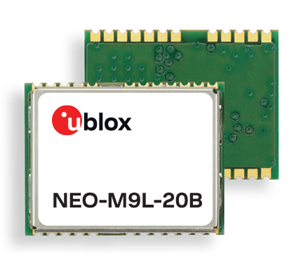
    U-blox is introducing a series of automotive-grade positioning modules that are operational up to 105° C (221° F). The NEO-M9L modules and the M9140-KA-DR chip are built on the robust u-blox M9 GNSS platform and use dead-reckoning techniques to provide accurate position data when satellite signals are compromised or unavailable.

    The u-blox NEO-M9L-20A and NEO-M9L-01A modules, as well as the M9140-KA-DR chip, are specially designed for first-mount automotive solutions. The modules and the chip are all automotive-grade, with the NEO-M9L-01A variant offering an extended operational temperature range up to 105 °C, making it suitable for integration on the roof, behind the windscreen, or inside hot electronics control units.

    Applications include integrated navigation systems such as in-vehicle infotainment (IVI) and head units, integrated telematics control units and V2X.

    The modules include new-generation 6-axis inertial measurement units (IMUs) that deliver low-latency 100-Hz RAW data output. The modules offer a low-latency 50-Hz position update rate, making it suitable for use in real-time applications. The automotive dead-reckoning (ADR) output combines the GNSS fix with IMU data to deliver accurate positioning output for various scenarios.

    Additional GNSS-only output enables seamless integration into a variety of third-party applications. The receiver also supports wake-on-motion, which enables smart features such as theft protection and power-efficient designs.

    The modules offer innovative sensor-based spoofing detection for advanced security and robustness. The chip offers protection against possible GNSS signal spoofing, which can cause navigation systems to report faulty position data or time.

    “The u-blox M9 sensor-fusion products address the latest automotive market demands for quality, reliability and robustness. Availability and trustworthiness of position output are increased by using concurrent reception of four GNSS constellations,” said Aravinthan Athmanathan, product manager, Product Center Positioning at u-blox. “In addition, the spoofing-detection feature is brought to a new level compared to the predecessor. Paired with low-latency position output, attitude, and sensor data, the u-blox NEO-M9L is ready to meet current and future challenges facing the automotive market.”

    All the module variants are compliant with AEC-Q104, the latest standard for ensuring the reliability of modules used in automotive applications. Engineering samples and evaluation kits will be available by the end of September.

  • Rx Networks adds StarCourse extended ephemeris services

    Rx Networks adds StarCourse extended ephemeris services

    Rx Networks has added a new extended ephemeris service called StarCourse.

    According to the company, real-time ephemeris services provide GNSS chipsets in connected mobile devices a headstart in determining position accurately and quickly. For devices with limited connectivity, typical extended ephemeris solutions have provided a headstart with 7-14 days of ephemeris data.

    With the evolution of the internet of things (IoT), low power consumption and a limiting of connection time are essential for extending the usable life of a device. This creates a challenge for IoT vendors seeking an extended ephemeris offering that can minimize onboard resource usage without compromising accuracy.

    The new StarCourse service provides a 50% reduction in RAM requirements, 90% reduction in CPU cycles, and ephemeris accuracy exceeding that of previous market offerings. This empowers Rx Networks customers to extend the usable life of their products while delivering an excellent positioning experience, the company said. Full data customization is offered to StarCourse subscribers, allowing them to create optimal solutions for their needs.

    StarCourse enables autonomous positioning on a wide array of connected GNSS IoT devices, including asset tracking, wearables, in-dash navigation and mobile devices. For situations where accuracy is paramount, StarCourse Premium provides ultra-precise predicted ephemeris for the first 24 hours.

    “GNSS assistance services are essential to solving the spatial intelligence requirements of the booming IoT world,” said Chris Perriam, product owner at Rx Networks. “StarCourse endeavours to quickly enlighten all connected devices with location.”

    Rx Networks provides location information to strengthen the connection between people, devices and businesses by improving the GNSS experience and creating enhanced opportunities for next-generation products and services.

    Image: Rx Networks
    Image: Rx Networks