Category: Applications

  • Hexagon’s new HxGN Mass Transit improves public transportation operations

    Hexagon’s new HxGN Mass Transit improves public transportation operations

    System optimizes field operations and monitoring of assets through 3D, AI and mobile capabilities

    Hexagon’s Safety, Infrastructure & Geospatial division has introduced HxGN Mass Transit, a geospatial transportation infrastructure management system with 3D and artificial intelligence (AI) capabilities for visualizing and analyzing transit and rail assets and operations.

    HxGN Mass Transit serves as a single source of truth for infrastructure data, enabling rail-bound and transit operators to easily inspect, validate and share information on the fly.

    HxGN Mass Transit combines asset and spatial data from various business systems into an integrated system, allowing operators to visualize and analyze their entire network and services. It reduces data duplication, provides access to accurate and up-to-date information and delivers greater efficiency for managing data, workflows and transit networks and operations.

    Image: MarcelStrelow/iStock/Getty Images Plus/Getty Images
    Zurich is using HxGN Mass Transit for its trams and buses. (Image: MarcelStrelow/iStock/Getty Images Plus/Getty Images)

    Now in Zurich and Frankfurt

    HxGN Mass Transit is already delivering benefits to public transportation organizations.

    “Every day, we transport more than 900,000 passengers around Zurich on our 510-kilometer network with 75 tram and bus lines,” said Daniel Steger, head of electrical infrastructure, Zurich Public Transport. “Maintaining our infrastructure is vital. HxGN Mass Transit will allow us to monitor rail tracks, overhead cables and the condition of bus stops to ensure we keep the citizens and visitors of Zurich moving.”

    “HxGN Mass Transit is an essential tool for managing our assets,” said Dominik Rabenau, head of data management at VGF Frankfurt’s infrastructure division. “The mobile application provides easy monitoring and the ability to update information of our timetable displays located at all stations, platforms and stops.”

    Typically, transportation agencies must rely on different data sources spread across multiple systems, departments and formats. This prevents viewing data in real time, making it difficult to gain a holistic view of asset conditions and to coordinate maintenance.

    Digital Twin of City Network

    Built on top of Hexagon’s M.App Enterprise, HxGN Mass Transit overcomes these challenges. It goes beyond a simple map, providing an advanced digital twin of a city’s entire public transportation network – from track, stops and switches to construction sites, ticket machines, benches and garbage cans. It offers capabilities and workflows for supervisors, analysts, asset and operations teams and others.

    “Urban population growth, increasing demand for mobility options and a greater focus on sustainability have driven interest and investment in public transportation,” said Steven Cost, president, Hexagon’s Safety, Infrastructure & Geospatial division. “By improving the ability to visualize and understand networks in real-time, HxGN Mass Transit provides a solution to the global demand for more efficient and effective public transportation.”

    HxGN Mass Transit is available worldwide now.

    To see a demo of HxGN Mass Transit and learn best practices for managing data, workflows and transit networks, attend the session “Driving Smart, Real-time Data Through Public Transit Systems” at the HxGN LIVE Resiliency Series, a free virtual event focused on helping critical service providers achieve greater resiliency in operations. Register for the event here.

  • Parrot’s new ANAFI Ai UAV drone is 4G connected

    Parrot’s new ANAFI Ai UAV drone is 4G connected

    Photo: Parrot
    Photo: Parrot

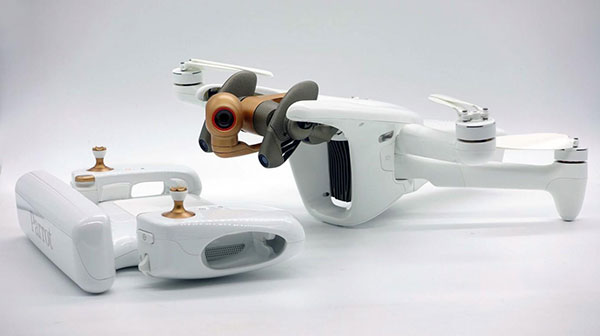
    Drone-maker Parrot has released a new drone for professionals. The ANAFI Ai UAV uses 4G as its main data link between the drone and the operator, so that users will no longer experience transmission limitations.

    The 4G also enables precise control at any distance. For beyond-visual-line-of-sight (BVLOS) flights, it stays connected even behind obstacles.

    For the first time, ANAFI Ai embeds a secure element in the drone and in its Skycontroller 4. The 4G link between the drone and the user’s phone is encrypted. The secure element protects both the integrity of the software and the privacy of data transferred.

    Parrot’s piloting application is open source. Parrot offers developers a software development kit (SDK) to create custom code for the drone to execute during flight. The SDK gives access to all flight sensors, including obstacle-avoidance sensors, occupancy grid and internet access.

    ANAFI Ai’s obstacle-avoidance system detects obstacles in all directions, using stereo cameras to sense objects and automatically avoid them.

    ANAFI Ai incorporates a 48MP main camera and a powerfully stabilized 4K 60-fps/HDR 10 camera to capture finely detailed aerial images and smooth video footage.

    ANAFI Ai will be available in the second half of 2021 through Parrot Drone Enterprise Partners and Enterprise Drone Reseller Network.

  • Charting Hong Kong’s nooks and crannies

    Charting Hong Kong’s nooks and crannies

    Photo: Yongyuan Dai/iStock/Getty Images Plus/Getty Images
    Photo: Yongyuan Dai/iStock/Getty Images Plus/Getty Images

    Team Provides Accurate 3D Maps for Smart City Applications

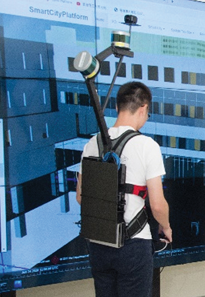
    The PolyU team's mobile mapping backpack. (Image: The Hong Kong Polytechnic University)
    The PolyU team’s mobile mapping backpack. (Image: The Hong Kong Polytechnic University)

    According to 2019 statistics, more than 10,000 residential buildings in Hong Kong are at least 50 years old. Most of these buildings lack 3D indoor building information models (BIM), which creates challenges when it comes to reconstruction or maintenance.

    In response, a team at Hong Kong Polytechnic University (PolyU) has developed a lightweight and reliable 3D mobile mapping system in a backpack. The system can easily measure cities and obtain 3D maps with centimeter-level accuracy. It can be used to build spatial data infrastructure, which supports smart city applications in many fields.

    The system uses advanced technologies such as simultaneous localization and mapping (SLAM), useful in urban canyons where GNSS signals can be spotty. It can carry out continuous data collection in complex indoor and outdoor environments, and is particularly suitable for high-density and complex urban environments, such as those in Hong Kong.

    The mapper is providing a special boon to modular integrated construction (MIC) in the city. With MIC, free-standing integrated modules are prefabricated and then transported to the site for installation in a building. However, the trucks hauling the large components can’t always maneuver through narrow streets in Hong Kong’s urban areas.

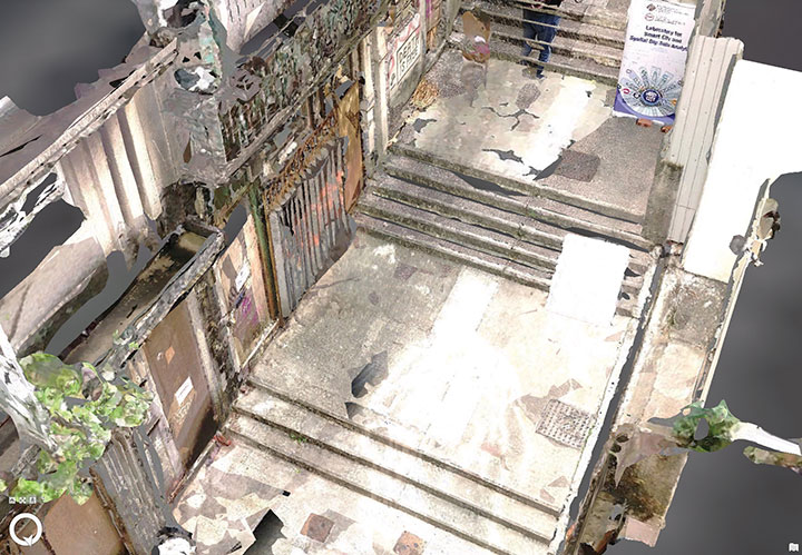
    One of many narrow streets mapped in downtown Hong Kong. (Image: The Hong Kong Polytechnic University
    One of many narrow streets mapped in downtown Hong Kong. (Image: The Hong Kong Polytechnic University

    To address the issue, the PolyU team collaborated with the Hong Kong Construction Industry Council, providing its mobile-mapping backpack to conduct 3D measurement of critical road sections. The project identified and mapped obstacles, and optimized the route for transporting oversized components to avoid narrow passages.

    Mobile-mapping backpacks also can be used to create detailed indoor 3D models to support firefighting and provide evacuation routes for personnel at the fire scene.

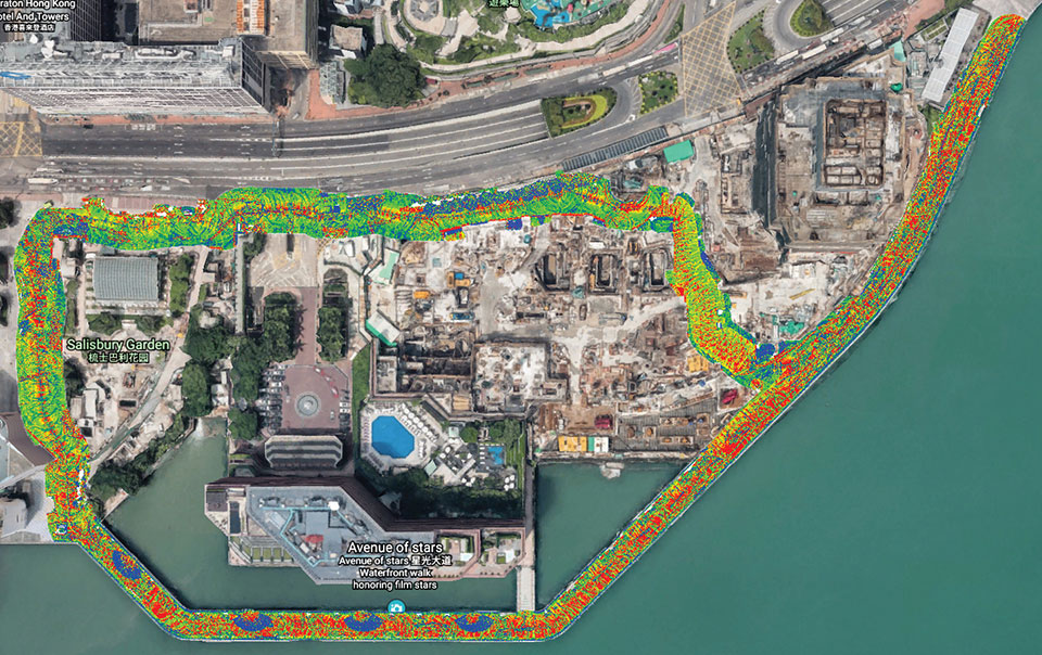
    The route taken by the mobile mapping backpack carrier in the harbor area. (Image: The Hong Kong Polytechnic University)
    The route taken by the mobile mapping backpack carrier in the harbor area. (Image: The Hong Kong Polytechnic University)
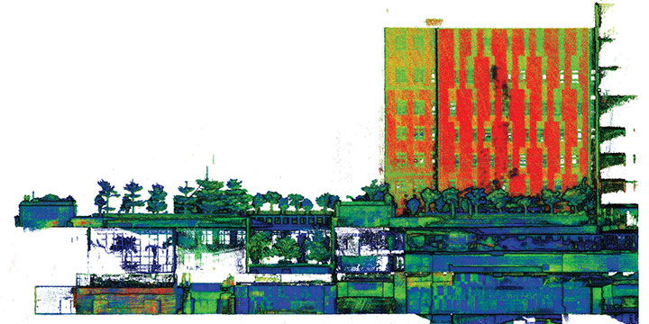
    A sample point cloud from the mobile mapper. (Image: The Hong Kong Polytechnic University)
    A sample point cloud from the mobile mapper. (Image: The Hong Kong Polytechnic University)

    The mobile mapper is one of the technologies developed by PolyU’s Smart Cities Research Institute, established in 2020 to help address social issues and provide solutions for smart city development. In March, the institute’s projects received a gold medal at 2021 Inventions Geneva Evaluation Days.


  • Septentrio’s AsteRx SBi3 enables XenomatiX lidar 3D mapping

    Septentrio’s AsteRx SBi3 enables XenomatiX lidar 3D mapping

    AsteRx SBi3 enables highly accurate and reliable 3D mapping solutions based on sensor fusion with lidar

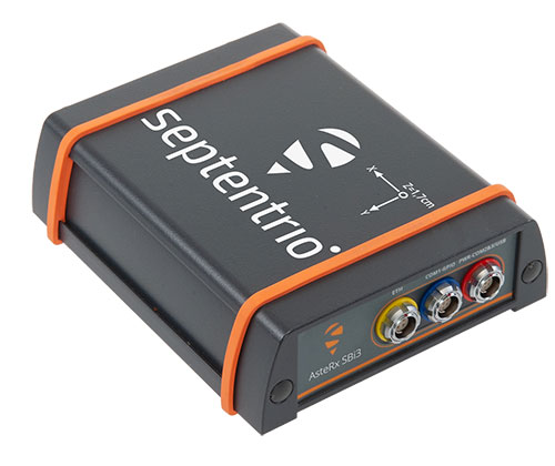
    The AsteRx-i3 Pro+ in a rugged housing. (Photo: Septentrio)
    The AsteRx-SBi3 Pro+ in a rugged housing. (Photo: Septentrio)

    Septentrio, a leader in high-precision GNSS/INS positioning solutions, and XenomatiX, provider of true solid-state lidar technology for autonomous applications and road management solutions, are starting a partnership enabling high-quality lidar solutions.

    XenomatiX will be using the compact and robust GNSS/INS receiver from Septentrio, AsteRx SBi3 Pro+, to provide analysis of pavement conditions geolocated with millimeter accuracy.

    Septentrio’s high-quality GNSS/INS will be a part of Xenomatix’ road lidar XenoTrack, used by road surveyors and road management companies. Septentrio’s AsteRx SBi3, a high-performance RTK GNSS/INS receiver with a dual-antenna setup, ensures centimeter-accurate geotagging of the XenoTrack point-cloud frames for relative and global millimeter accuracy over large distances.

    Moreover, the GNSS/inertial measurement unit (IMU) integration algorithm enables dead reckoning — continuous positioning in environments of low satellite visibility where GNSS outages occur.

    While traditional road scanning based on laser profilers rely solely on extremely accurate GNSS/inertial navigation system (INS) to stitch consecutive profiles together, the XenoTrack captures a 3D topography of an entire area in a single shot. The XenomatiX sensor-fusion algorithms combine visual SLAM techniques with GNSS, IMU and CAN to obtain a seamless map of the road shape.

    Septentrio’s proprietary GNSS+ technology plays a key role in delivering the accuracy and reliability needed for XenoTrack. The company’s AIM+ advanced interference mitigation technology ensures robust positioning even in the presence of jammers, which may be aboard vehicles trying to avoid road tolling. When the sky is obstructed for an extended period, the built-in RAIM+ integrity algorithm serves as an indicator of when it is best to give priority to other sensor inputs to maintain a high-quality solution.

    XenomatiX offers a complete mapping system as well as services including data from the XenoTrack sensor, camera and real-time kinematic GNSS/INS receiver with dual antenna in an easy-to-install solution on a standard vehicle.

  • U-blox releases explorer kits for high-precision indoor positioning

    U-blox releases explorer kits for high-precision indoor positioning

    Leveraging Bluetooth direction finding technology, the solutions demonstrate sub-meter level position accuracy for a variety of industrial and consumer applications

    Photo: U-blox
    Photo: U-blox

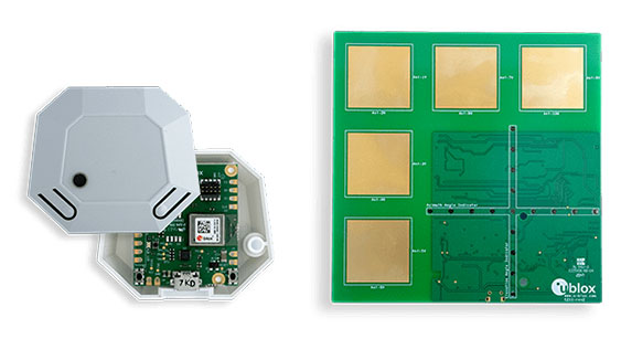
    U-blox has released two explorer kits for product developers to evaluate the potential of Bluetooth direction finding and high-precision indoor positioning. Designed for low power consumption, simple deployment, and low cost of ownership, the u-blox XPLR-AOA-1 and XPLR-AOA-2 explorer kits will test the technology’s capabilities to enable a variety of applications including access control, collision detection, smart appliances, indoor positioning and asset tracking.

    Recognizing the growing demand for more accurate indoor positioning solutions, the Bluetooth special interest group (SIG) released Bluetooth direction finding, offering a major improvement over previous receiver signal strength indicator (RSSI)-based solutions.

    Bluetooth direction finding makes it possible to determine the direction that radio signals travel from a mobile tag to one or several fixed anchor points. Using angle-of-arrival (AoA) technology, anchor points comprising antenna arrays connected to Bluetooth receivers can detect the direction, or angle, to the mobile tag, which transmits a Bluetooth signal. When a constellation of such multi-antenna anchors is deployed, AoA technology can be used to triangulate the precise location of a mobile device or tag.

    The u-blox XPLR-AOA-1 and XPLR-AOA-2 explorer kits showcase one of the first complete Bluetooth-based tracking solutions – from the tag to the cloud – to reliably offer sub-meter-level accuracy in indoor environments.

  • Qualcomm upgrades premium tier with Snapdragon 888+

    Qualcomm upgrades premium tier with Snapdragon 888+

    Upgraded flagship mobile platform to power commercial smartphones from ASUS, Honor, Motorola, vivo and Xiaomi in second half of 2021

    Photo: Qualcomm
    Photo: Qualcomm

    Qualcomm Technologies Inc. announced the Snapdragon 888 Plus 5G Mobile Platform, a follow-on to the flagship Snapdragon 888. These two platforms power more than 130 designs announced or in development. The product was introduced at Mobile World Congress, taking place this week in Barcelona, Spain.

    Satellite systems supported include all four constellations (GPS, Beidou, Galileo, GLONASS) with dual-frequency GNSS. Additional systems supported include NavIC, QZSS and SBAS.

    Snapdragon 888 Plus provides AI-enhanced gameplay, streaming, photography and premium connectivity. Compared to its predecessor, Snapdragon 888 Plus offers an increased Qualcomm Kryo 680 CPU Prime core clock speed at up to 3.0 GHz and the 6th generation Qualcomm AI Engine with up to 32 TOPS AI performance, which is more than 20% improvement.

    “Snapdragon is synonymous with premium Android experiences. Our latest flagship Snapdragon 888 Plus 5G Mobile Platform will help deliver the premium entertainment, connectivity, and gaming experiences users deserve,” said Christopher Patrick, senior vice president and general manager, mobile handset business, Qualcomm. “We’re excited to see OEMs launch with products based on our highest performing platform.”

    Photo: Qualcomm
    Photo: Qualcomm
  • Rx Networks TruePoint.io global PPP corrections now quad-constellation

    Rx Networks TruePoint.io global PPP corrections now quad-constellation

    Logo: Rx NetworksRx Networks TruePoint.io global precise point positioning (PPP) correction service now provides quad-constellation support.

    More mobile devices are integrating multi-constellation GNSS chipsets for better positioning. With quad-constellation expanded multi-constellation support, Rx Networks TruePoint.io global precise point positioning (PPP) correction service unlocks that accuracy, providing global PPP corrections for every major GNSS constellation those chips can track.

    TruePoint.io global PPP originally delivered GPS and GLONASS corrections. Now, it also provides corrections for Galileo and BeiDou. Mass-market multi-constellation GNSS chipsets can now augment all their satellite measurements with accuracy and fully leverage their positioning capabilities with quad-constellation support.

    Consumer devices now have the potential to achieve 50-cm position accuracy when using Rx Networks services for any of the four GNSS constellations. Other internet of things (IoT) and infrastructure applications that do not require real-time positioning can realize 10-cm accuracy in a variety of environments.

    Multi-constellation correction capability ushers in new possibilities and use cases for the connected receiver, according to Rx Networks.

    TruePoint.io remains ubiquitous and as flexible as possible to GNSS chipsets using industry standard formats, and is also receptive to custom integration services for unique usage scenarios. By offering PPP and other high accuracy services in a variety of data standards, TruePoint.io empowers telecom providers with a straightforward approach to integrating high- accuracy services that provide more value to their client devices, and propels the development of exciting new use cases.

    “With this new expansion of TruePoint.io, applications already serviced by Rx Networks can accelerate their market growth objectives with better accuracy and precision using constellations ideal for target regions,” said Vincent Chen, product manager of Truepoint.io. “Being able to deliver global PPP corrections for GPS, GLONASS, Galileo and BeiDou also sets the stage for the addition of more constellations like QZSS. Stay tuned.”

  • Microchip Technology unifies timing for critical infrastructure with firewall

    Microchip Technology unifies timing for critical infrastructure with firewall

    The company’s TimePictra 11 timing infrastructure management system works with its BlueSky GNSS Firewall to create a unified view for a more secure network timing architecture

    Image: Microchip Technology
    Image: Microchip Technology

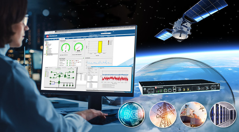
    Microchip Technology Inc. has integrated its BlueSky GNSS Firewall with its TimePictra 11 synchronization monitoring and management platform to protect 5G networks and other critical timing infrastructure from GPS signal jamming and spoofing while providing single-console visibility across the entire timing architecture.

    The move was made to meet the needs of 5G wireless infrastructure, which has more complex and higher density synchronization needs than previous generation networks. 5G is highly dependent on the integrity of live-sky GNSS timing signals.

    “Microchip’s TimePictra system improves overall situational awareness by managing network timing synchronization as well as our GNSS firewall that improves a network’s resilience through real-time GPS threat detection and mitigation,” said Randy Brudzinski, vice president, Frequency and Time Systems business unit. “Our solution’s scalability is particularly valuable for mobile operators who can use TimePictra to monitor GNSS-based source clocks along with our secure network-based timing distribution solutions to deploy a highly resilient timing architecture for their transition to 5G.”

    In addition to requiring precise timing from GNSS sources, critical infrastructure operators need accurate timing to be distributed across their networks so they can ensure reliable performance and service delivery. TimePictra provides full control and monitoring for resilient timing architectures created with Microchip’s broad product portfolio, including its TimeProvider 4100 grandmasters for 5G network synchronization.

    TimePictra also monitors the health and performance of these networks’ distributed Precision Time Protocol (PTP) client clocks. Integrating BlueSky GNSS Firewall management into the TimePictra console view gives operators a unified picture of the entire timing architecture and all timing sources.

    Beyond supporting 5G deployments, TimePictra provides aviation, railway and maritime ports with a regional, national or global view of GNSS reception. TimePictra with BlueSky GNSS Firewall monitors key GNSS observables to detect live-sky signal anomalies and deliver early alerting so that operators can engage alternate procedures that do not rely on GNSS. These capabilities are increasingly important when public safety depends on position and navigation for daily operations.

    Microchip’s TimePictra timing infrastructure management system with its Blue Sky GNSS Firewall is available today.

  • Juniper Systems launches Cedar rugged tablet with GNSS functionality

    Juniper Systems launches Cedar rugged tablet with GNSS functionality

    Photo: Juniper Systems
    Photo: Juniper Systems

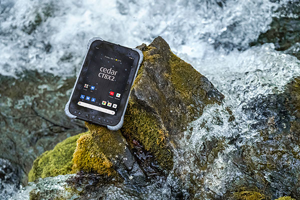
    Juniper Systems is has launched its latest rugged tablet, the Cedar CT8X2. The new tablet offers increased processing power, RAM and storage, running on the Android 10 operating system. Despite these features, the CT8X2 retains the same powerful GNSS functionality of the previous Cedar generation for the same price.

    “The CT8X2 is our best Cedar tablet to date,” said Cody Draper, Cedar product manager. “It exceeds expectations in terms of price, performance and versatility. It is a perfect device for those looking for a mobile data-collection device that offers a much greater degree of ruggedness than a consumer product.”

    Powered by an octa-core Snapdragon CPU from Qualcomm, the CT8X2 allows for larger files compared to the previous Cedar. Greater onboard storage prevents users from needing to offload data frequently and provides sufficient space for applications. With GNSS accuracy of about one meter in open skies and five meters under tree canopy, the CT8X2 offers capable GNSS positioning that far exceeds the accuracy of typical consumer devices. The CT8X2 also has a high-resolution screen.

    “The performance increase of the CT8X2 gives users a very capable device in the field,” Draper said. “We were able to provide these advancements in performance and GNSS accuracy while maintaining our affordable price point.”

    The CT8X2 is now available for purchase.

  • Building a better world: Esri UC announces plenary speakers

    Building a better world: Esri UC announces plenary speakers

    logo

    The 2021 Esri User Conference — taking place virtually July 12-15 — has announced its plenary session theme and speakers.

    “At this year’s plenary session, we’ll explore a vision for building a better world,” said Esri President Jack Dangermond, who will deliver the keynote address. With the theme of GIS—Creating a Sustainable Future, attendees can learn from leaders in human storytelling, racial equity, ocean preservation and climate resilience, as well as discover the latest geospatial innovations.

    Following the keynote, a two-part Plenary Session provides conversations and stories from these speakers:

    • Paul Salopek | Founder, Out of Eden Walk, National Geographic
      A Walk Through the Anthropocene
    • La June Montgomery Tabron | President and CEO, W.K. Kellogg Foundation
      Expanding Racial Equity through Community Action
    • Enric Sala | Explorer in Residence, National Geographic Pristine Seas
      2021–2030: Our Last Best Chance to Protect the Ocean for the Benefit of Humanity
      Protecting the Global Ocean for Biodiversity, Food and Climate
    • Secretary Wade Crowfoot | California Natural Resources Agency
      Nature-Based Solutions in California: Combating Climate Change and Achieving 30×30

    The Esri UC will also provide a look at new GIS technologies in expert-led demonstrations, including ArcGIS Image for ArcGIS Online. Attendees can learn to directly integrate imagery into your workflows by fast-tracking image analysis and easily sharing data to derive and communicate critical insights.

    Registration for the Plenary Session is complimentary. Full event access is available to Esri users current on their maintenance or subscriptions.

    The detailed agenda for the conference is available online.

  • New Eos Bridge makes instruments iOS compatible

    New Eos Bridge makes instruments iOS compatible

    Eos Positioning Systems, the global manufacturer of Arrow Series GNSS receivers, has released Eos Bridge, which enables almost any instrument to become iOS Bluetooth compatible.

    Photo: Eos Positioning
    Photo: Eos Positioning

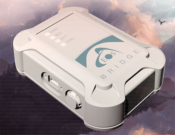
    The Eos Bridge is a small, pocket-sized device that connects to instruments via Bluetooth Classic or serial port, and transmits data from them to any Apple iOS device, such as iPhone or iPad, Android device or Windows mobile device.

    The Eos Bridge offers two connectivity methods to virtually hundreds of instruments:

    First Method: Bluetooth Classic to Apple iOS Bluetooth

    Instruments that are equipped with non-iOS Bluetooth are now able to connect to Apple iOS devices using the Eos Bridge, including laser rangefinders and utility-locating instruments.

    Second Method: Serial port to iOS, Android and Windows devices

    With the Eos Bridge, instruments whose only connectivity option is a serial port may now be connected to any iOS, Android or Windows device via Bluetooth. This includes any instrument or sensor with an RS-232 serial port, for example.

    The Eos Bridge is lightweight, at approximately 150 grams (about 5.3 ounces). It can be worn clipped to a belt, stored in a pocket, or mounted to an instrument or sensor. The battery lasts 48 to 72 hours.

    The Eos Bridge expands the potential pairings of legacy instruments and sensors by making them Bluetooth compatible with modern mobile devices and Arrow GNSS receivers. Two immediate applications for current Arrow GNSS users include Eos Laser Mapping for ArcGIS offset data-collection, and Eos Locate for ArcGIS for underground utility mapping. Both solutions are available on iOS.

  • U-blox updates ZED-F9R positioning module for slow-moving vehicles

    U-blox updates ZED-F9R positioning module for slow-moving vehicles

    U-blox has released a firmware update for its ZED-F9R positioning module, bringing robust centimeter-level positioning to slow-moving use cases such as robotic lawnmowers, e-scooters and shared bicycles.

    Based on the ZED-F9R high-precision sensor-fusion module, the u-blox ZED-F9R-02B was designed for use in autonomous and industrial applications that require simple and efficient implementation and where rapid access to highly accurate positioning data is key, even in challenging signal environments such as dense cities.

    The ZED-F9R uses the u-blox F9 multi-band GNSS receiver platform to concurrently track up to four GNSS constellations. Applying real-time kinematic (RTK) techniques, the module can derive positioning data with centimeter-level accuracy.

    The high-precision GNSS measurements are fused with data from the module’s inertial measurement unit (IMU), GNSS correction data, odometry information, and a vehicle dynamics model to provide high-quality positioning accuracy in situations where GNSS alone would fail. The receiver includes dynamic models for robotic lawnmowers, e-scooters and automobiles.

    The ZED-F9R-02B integrates the u-blox GNSS correction data service, broadcast in the highly scalable state-space representation format, making it easier to deliver fast time-to-market precise positioning solutions.

    An autonomous lawn mower trims the grass in a park in Finland. (Photo: Scharfsinn86/iStock/Getty Images Plus/Getty Images)
    An autonomous lawn mower trims the grass in a park in Finland. (Photo: Scharfsinn86/iStock/Getty Images Plus/Getty Images)

    Robotic lawnmowers achieve further improvements in terms of their positioning accuracy from the module’s ability to calibrate its dead-reckoning system even at low speeds. The module’s highly accurate position output lets end users precisely delimit the mowing area using software rather than with boundary wires, and deploy robotic lawnmowers on complex lawn shapes while excluding trees and shrubs. Users can align each pass of the mower with the next more accurately than before, delivering a professional-looking striped lawn.

    According to U-blox, combining these features allows product designers to use the module to create mowing equipment that enables “robotic mowing as a service” capable of operating in complex environments without the upfront cost and commitment of installing boundary wires.

    “Our new ZED-F9R-02B high-precision module is a turnkey dead-reckoning solution that will enable designers to bring products that need dead-reckoning technology to market more quickly than if they had to implement it from scratch,” said Alex Ngi, product manager, Industrial Navigation and Robotics, Product Center Positioning at u-blox. “It will also allow companies working in niche markets to employ dead-reckoning technologies without needing to build and maintain expertise in the subject.”

    The ZED-F9R-02B offers support for a range of correction services, including the SPARTN format, which will make it straightforward to distribute GNSS correction data over large geographical areas.

    iGPSPort cycling computer. In another announcement, U-blox and iGPSPORT, a sports hardware and data service provider operating out of Wuhan, China, have announced the iGS320 cycling computer, which builds on the u-blox M10 positioning platform. The cycling computer leverages the U-blox M10 platform’s ultra-low power consumption, compact size, and its ability to track all four GNSS to offer endurance athletes a superior user experience.

    Adopting the U-blox M10 positioning platform in its iGS320 cycling computer brought iGPSPORT an 80 percent increase the power autonomy to deliver 72 hours of continuous tracking, up from 40 hours in their previous solution. Concurrent reception of up to four GNSS constellations increases coverage and accuracy in otherwise challenging signal environments.