Category: Applications

  • New gateway connects users to Open Maps for Europe

    New gateway connects users to Open Maps for Europe

    Image: EuroGeographics
    Image: EuroGeographics

    Free-to-use maps from more than 40 European countries will be made available through a new online gateway.

    Open Maps for Europe will signpost and provide easy access to pan-European open data created using official map, geospatial and land information.

    The project, which is co-financed by the Connecting Europe Facility of the European Union, is coordinated by EuroGeographics, the voice of European National Mapping, Cadastral and Land Registration Authorities, in partnership with the National Geographic Institute (NGI) Belgium.

    Users will be able to access the data, created by the not-for-profit membership association, through an online interface developed by thinkWhere. The specialist in open source geographic information system (GIS) technologies will deliver the enhanced gateway for discovering, viewing, licensing and downloading the open datasets after winning an open tender.

    The open data will include topographic data, a digital elevation model, imagery, a cadastral index map, and a regional gazetteer. The first maps are expected to be available in summer 2021.

    “As the official national sources of map, cadastral and land information, our members’ data is fundamental to the everyday lives of people across Europe,”said Angela Baker, program manager, Data Access and Integration, EuroGeographics. “We may not always realise it, but their authoritative information underpins our public services, provides certainty of property ownership and helps to save precious time and potentially save lives when responding to emergencies. In an ever-connected world, it is also increasingly used in a wide range of applications relied upon by both citizens and businesses.”

    “The Open Data Directive recognises that the value of data lies in its use and re-use. By providing easy access to free to use harmonised maps for Europe, our members want to boost the development of these innovative services. Their aim is to encourage greater use of their official geospatial data to drive market development and economic growth, and increase competitiveness by reducing costs.

    “By working to ensure their data is interoperable, readily available and easily accessible, they are demonstrating a commitment to delivering Open Maps for Europe both now and in the future.”

    Alan Moore, Chief Executive, thinkWhere added: “We are delighted to be working with EuroGeographics and its members on the Open Maps for Europe project where the primary aim is to drive up the use of official geospatial and open data.”

    “Our mission is to make geographic data highly accessible, easy to use and an essential part of your information architecture. Collaborating with EuroGeographics and its members we will harness the power of our cloud-based geospatial data infrastructure and drive the development of a user-centric portal that makes it easy to find, view, publish and share the rich suite of pan European digital mapping, cadastral and topographic datasets.”

    Open Maps for Europe runs until Dec. 31, 2022.

    EuroGeographics is an international not-for-profit organization and the membership association for the European National Mapping, Cadastral and Land Registry Authorities. It brings together members from 46 countries, covering the whole of geographical Europe.

  • InfiniDome provides GPS monitoring and Protection Solution to Israel Railways

    InfiniDome provides GPS monitoring and Protection Solution to Israel Railways

    A train arrives at Tel Aviv University Station on the Israeli Railway in Tel Aviv. (Photo: svarshik/iStock Editorial/Getty Images Plus/Getty Images)
    A train arrives at Tel Aviv University Station on the Israeli Railway in Tel Aviv. (Photo: svarshik/iStock Editorial/Getty Images Plus/Getty Images)

    InfiniDome Ltd., a GPS security company, is joining with with Israeli partner Focus Telecom, in a new country-wide project with Israel Railways. The project involves deployment by Focus Telecom of GPS repeaters at more than 30 railway stations across Israel, providing accurate, location-based service indoors at all locations for a new Israel Railways ticketing app.

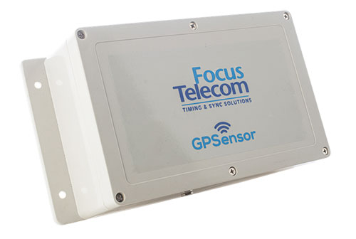
    A critical component of the project is a monitoring service that detects and provides alerts of any GPS disruption or interference in real time, as they are identified. This is facilitated by infiniDome’s IoT GPSensors and its cloud-based GPS monitoring service, infiniCloud.

    “Incorporating infiniDome’s proven resilient PNT capability to monitor and protect such a critical GPS service is a necessary enhancement for government designated critical infrastructures,” said Ehud Sharar, Focus Telecom CEO.

    Photo: Focus Telecom
    Photo: Focus Telecom

    InfiniDome’s monitoring technology for critical assets detects and alerts operators of threats and disruptions of the essential GPS signals. These threats can originate from both malicious or natural causes.

    “GPSensor IoT technology combined with our infiniCloud GPS security cloud assures real-time alerts about jamming attacks. All GPS signal data and its assured integrity are available as real time data so Israel Railways can react immediately and reduce downtime of the network,” said Omer Sharar, infiniDome CEO.

    Israel Railways is the cornerstone of Israeli critical infrastructure. In 2018, Israel National Railway carried 68 million passengers. This same infiniDome GPS monitoring and protection technology is now available to defend critical infrastructure assets worldwide.

  • Registration open for ION Joint Navigation Conference 2021

    Registration open for ION Joint Navigation Conference 2021

    Logo: ION JNCThe Institute of Navigation (ION) announces that registration for the Joint Navigation Conference (JNC) is now open.

    The JNC, sponsored by the Military Division of the Institute of Navigation, will be held Aug. 24-26 (FEDCON U.S. ONLY) at the Northern Kentucky Convention Center in Covington, Kentucky (Greater Cincinnati, Ohio).

    The Classified Sessions (Secret U.S. ONLY) will be held Aug. 27, at the Air Force Institute of Technology on Wright-Patterson Air Force Base, Ohio. Visit requests and approvals are required for all session attendees.

    View the JNC 2021 program and register at ion.org/jnc.

    JNC 2021 is the largest U.S. military positioning, navigation and timing (PNT) conference of the year, with joint service and government participation.

    Four new panel sessions have been introduced to this year’s technical program, which will host leaders and decision makers as they discuss and debate

    • MGUE Integration
    • Rapid Agile Development and Manufacturing
    • the National Critical Infrastructure Threat
    • Combatant Command Joint Urgent Operation Need (Secret, U.S. Only).

    The technical program will focus on enhancing dominance and resilience for warfighting and homeland security PNT, and will include keynote addresses from:

    • William B. Nelson, director, Assured Positioning Navigation &Timing (APNT) Cross Functional Team (CFT), U.S. Army Futures Command
    • Ray Chartier, Jr., Safety of Navigation Mission manager, National Geospatial Intelligence Agency
    • General David D. Thompson, vice xhief of Space Operations, United States Space Force
    • Bradford Parkinson, Stanford Center for PNT

    Attendance Restricted for JNC Technical Sessions

    Conference attendance for both FEDCON (U.S. ONLY) (Aug. 24-26) and Classified Sessions (U.S. ONLY) (Aug. 27) will be screened by the Joint Navigation Warfare Center. Visit requests and approvals are required for all technical participants.

    The exhibit hall is open to any registered conference attendee or exhibiting company representative, and all materials shall be designated DISTRO A/Publicly Releasable After Review.

    Government-issued photo ID will be required to access all conference events.

    If you have questions, contact the Institute of Navigation at [email protected] or by calling +1-703-366-2723.

  • Lidar-based system for high-speed tolling coming soon to US highway

    Lidar-based system for high-speed tolling coming soon to US highway

    First commercial deployment to be installed on a major turnpike used by tens of millions of vehicles every year

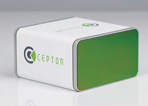
    An electronic tolling system that uses high-performance lidar sensors from Cepton and a vehicle identification solution from Red Fox ID is expected to be deployed on a major highway turnpike crossing multiple states in the United States.

    The turnpike project is expected to provide fast, accurate, real-time tolling to enable smooth traffic flows. Specifics of the project — including states involved and the timeframe of installation — were not disclosed.

    Photo: Cepton
    Photo: Cepton

    Based on an extended collaboration with leading lidar solution provider Cepton, Red Fox ID — a designer and developer of vehicle identification and classification solutions — has developed a multi-lane, free-flow tolling system called Quantum, which is able to accurately detect, track and classify vehicles of any size or type at highway speeds.

    Quantum uses Cepton’s Micro Motion Technology (MMT)-based Sora-P60 or Sora-P90 lidar sensors for high-resolution vehicle profiling, to enable integrators and road operators to achieve highly accurate customer billing in real time, with free flow, barrier-free tolling.

    For tolls to be charged correctly based on vehicle class, traditional tolling systems often use tollbooths for manual processing or depend on vehicle speed-reduction infrastructure to allow for time to capture vehicle information. That can cause congestion, increased emissions and frustration among customers.

    Advanced systems that aim to enable faster tolling are often subject to significant errors, such as missed vehicles or wrong vehicle classification, because of limitations of the sensors being used, such as cameras and weight-based ground sensors. Vehicle-classification errors can have significant operating cost consequences for tolling operators, while leakage leads to lower revenues. With tollways processing tens of millions of vehicles a year, the cumulative impact of inaccuracies and errors creates significant administrative costs, losses and customer dissatisfaction.

    Red Fox ID’s Quantum solution adds an extra layer of accuracy to the tolling system by integrating Cepton’s lidar technology. A gantry-mounted system using Quantum is able to accurately detect and track vehicles even as they switch lanes. Quantum captures and extracts high-quality information, such as vehicle velocity, size and class. All of that information is used as input to a separate billing system to compute and apply the appropriate tolling charge.

    Quantum can also direct camera-based systems on the gantry to capture a vehicle’s front and rear plates in the event that a transponder cannot be detected. Through these innovations, Quantum has demonstrated a vehicle-detection accuracy in all traffic conditions of 99.96%, an axle-classification accuracy in all traffic conditions of 99.9% and a vehicle-length accuracy of +/-5%. The system uses Cepton’s Sora-P sensor family which has been tested and proven during extended trials, including in various weather and light conditions.

    The recently released Sora-P90 lidar features a 380-Hz frame rate to deliver 1140 line scans per second, providing high-fidelity profiling of vehicles passing at highway speeds. Powered by Cepton’s patented, rotation-free, frictionless and mirrorless MMT, the Sora-P90 is rugged, reliable and scalable, making it suited for automated tolling applications.With a 90° horizontal field of view, the lidar can be set up using one gantry instead of two separate sensors and gantries, making overall deployment more cost effective.

    Red Fox ID has been working with Cepton on multiple trials and proof of concept projects across the globe since 2019. This has allowed both partners to expand the application of advanced lidar intelligence for high-accuracy tolling on highways and roadways in a growing list of countries, across North America, Europe, the Middle Eas, Africa and Asia.

    “Our industry’s drive for overhead tolling solutions has failed to materialize in the mainstream due, primarily, to a lack of sensors capable of achieving the high levels of accuracy required for a modern tolling product,” said Steve Bird, CEO of Red Fox ID. “The technical innovations enabled by Cepton offer us new design options. Improvements in the resolution of the data, the ability to deal with the full range of weather-related conditions, and the development of a sensor with an in-service lifespan suitable for tolling make it possible, for the first time, for us to develop an accurate, overhead free flow system. Our partnership with Cepton will be a game-changer in revolutionizing the tolling market.”

    “It is very clear that lidar’s uses extend far beyond just serving as the ‘eyes’ of autonomous vehicles,” said Jun Pei, CEO of Cepton. “Our lidar technology has a huge part to play in making our transport infrastructure smarter, safer, greener and more efficient, as we can see here following Quantum’s highly successful real-world testing. The key to success for toll operators and providers is minimal error and maximum yield, and we are excited to be partnering with Red Fox ID to help our mutual customers achieve this goal with our market-leading lidar technology. We look forward to working with them to expand our partnership worldwide.”

  • Hexagon releases machine-learning GIS tool for smart cities

    Hexagon releases machine-learning GIS tool for smart cities

    Hexagon’s Geospatial division has launched M.App Enterprise 2021, a significant update to its platform for creating geospatial and location intelligence applications. The latest release features new browser-based 3D capabilities and enhanced visual effects, plus the ability to create and configure custom applications more easily.

    M.App Enterprise 2021 adds complete and seamless integration with Hexagon’s LuciadRIA. Now, users can access LuciadRIA’s 3D features, including support for panoramic imagery, shading, ambient occlusion and other visualization effects, to build browser-based solutions with no development necessary.

    The latest version also features a new browser app configurator that makes it even easier to create spatio-temporal dashboards, known as Smart M.Apps. Additionally, Feature Analyzer has been expanded to allow users to add and manage multiple datasets on the fly and set up workflows. These enhancements enable more dynamic configurations, allowing field workers to be alerted quickly when action is required.

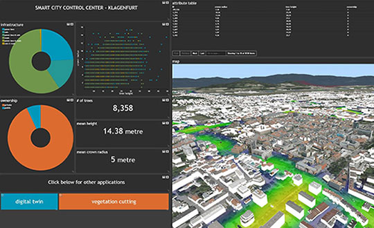
    The city of Klagenfurt, Austria — a long-time Hexagon customer — has already begun using M.App Enterprise 2021 to create a city app platform that features a detailed 3D urban landscape of the entire city.

    “This opens up endless possibilities for applications to automate several manual processes within different departments of the city,” said Günter Koren, head of the department of surveying and GIS at the city of Klagenfurt. “We believe M. App Enterprise will be an essential step in our journey to become a smarter, safer city for our 100,000 citizens.”

    The latest release contains other new features and improvements, including an overhauled style editor, a new default dark theme, options for customized theming and full support for SAP HANA databases.

    “M.App Enterprise 2021 helps organizations achieve smart monitoring of their cities, infrastructure and services by seamlessly incorporating location intelligence into enterprise systems and workflows,” said Georg Hammerer, chief technology officer of Hexagon’s Geospatial division. “With augmented visuals and dynamic configurations, this new version of M.App Enterprise can help customers easily set up powerful applications, allowing them to be more productive and efficient.”

    Screenshot: Hexagon Geospatial
    Screenshot: Hexagon Geospatial
  • Trimble introduces Siteworks SE Starter Edition for construction

    Trimble introduces Siteworks SE Starter Edition for construction

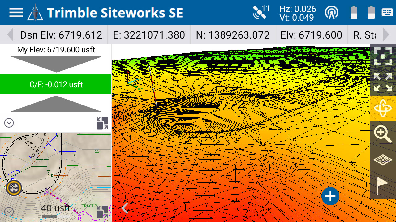
    The Trimble Siteworks SE Starter Edition. (Screenshot: Trimble)
    The Trimble Siteworks SE Starter Edition. (Screenshot: Trimble)

    Trimble has introduced the Trimble Siteworks SE Starter Edition, an entry-level construction surveying software program.

    With the program and a construction GNSS receiver, a supervisor, foreman, grade checker or site engineer can easily check a grade, slope or alignment and navigate the project more accurately and in less time than with traditional survey methods. It can also give more personnel on the jobsite access to survey technology, enabling more productive and efficient field crews.

    Trimble Siteworks SE Software is a simplified version of Trimble Siteworks Software, intended for users who do not require a full feature set and are interested in a lower-cost version to connect to GNSS only. The same colorful graphics, natural interactions and gestures, and self-discovery features found in Trimble Siteworks make the software easy to learn, so both experienced and new users can get up-to-speed quickly, Trimble said.

    Using the same data folder structure, file formats and workflows, Trimble Siteworks SE Software is fully compatible with Trimble Siteworks Software. Contractors can easily upgrade to the full version, making Siteworks SE an ideal entry point into construction technology for surveying.

    For contractors, Trimble Siteworks SE Software enables contractors to determine the location on a project, see cut/fill values to a design surface or alignment, or visualize constructible models in 3D. Users can measure feature (non-surface) points, lines and areas, or navigate to points, lines and alignments, and create PDF reports.

    In vehicle mode, users can capture high-accuracy measurements on steep slopes from a moving vehicle. Trimble Siteworks SE is compatible with a wide range of GNSS hardware configurations.

    Trimble Siteworks SE can share up-to-date information wirelessly between the field and the office to increase operational efficiency and reduce downtime.

  • Southwest Antennas releases rugged GPS/GLONASS antenna

    Southwest Antennas releases rugged GPS/GLONASS antenna

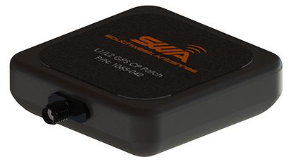
    Southwest Antennas has introduced a high-performance GPS and GLONASS active L1/L2 patch antenna for high-accuracy location service, timing and navigation applications.

    Part #1065-042 covers both the L1 and L2 bands, supporting military, commercial and industrial applications. For military users, the antenna supports the GPS P/Y code with +/-20-MHz bandwidth, allowing for increased accuracy, jam resistance and encryption for authorized military applications.

    Photo: Southwest Antennas
    Photo: Southwest Antennas

    The antenna’s built-in low-noise amplifier (LNA) and filters give it a total system active gain of +28 dB and out-of-band rejection of >50 dB (+50 MHz / -35 MHz of L1, +35 MHz / -45 MHz of L2). The specifications allow the antenna to operate in contested and congested radio frequency (RF) environments.

    “Our goal is to empower radio operators who require high-accuracy GNSS solutions with more choices for deployment and mounting,” said Benjamin Culver, president and co-owner of Southwest Antennas. “Adding onto our existing line of GPS antennas and gooseneck mounting options, users now have more freedom of choice in antenna placement to help overcome reception issues in challenging environments.”

    The low-profile radome allows the antenna to be easily tucked into pockets or modular lightweight load-carrying equipment (MOLLE) pouches and mounted on body armor, vests, rucksacks or other tactical gear. The custom black chrome SMA(f) RF connector ensures the antenna is waterproof, while allowing users to fully customize antenna placement on their gear and select their own cable type and length to suit their preference for mounting location away from their receiver.

    For additional flexibility in mounting locations, part #1065-042 features a magnetic mount integrated flush into the antenna’s radome, allowing it to be secured and removed quickly from any ferromagnetic surface. This extends the antenna’s operational capabilities through the ability to remotely locate the antenna away from the attached radio system to enhance satellite acquisition speed and signal strength when operating in environments with poor sky views.

    Applications include:

    • SAASM GPS, GLONASS, GNSS receivers, and other precision navigation receivers
    • Manpack and handheld radios, dismounted soldier-level communications
    • Small form-factor radios
    • Low-profile vehicle mounts and unmanned ground vehicles
    • Unattended/intelligent munitions systems
    • Aviators, combat search-and-rescue radios
    • IED recognition and destruction jamming systems
    • Law enforcement and first responders
    • Precision surveying receivers
    • Asset tracking
    • Precision timing applications
    • LBS and M2M applications
    • Oil and gas industries
  • KVH offers TACNAV 3D with photonic integrated chip technology

    KVH offers TACNAV 3D with photonic integrated chip technology

    KVH’s widely fielded tactical navigation system now upgraded with its patented PIC technology

    Photo: KVH Industries
    Photo: KVH Industries

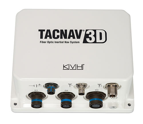
    KVH Industries’ TACNAV 3D tactical navigation system is now available with the P-1775 inertial measurement unit (IMU) featuring KVH’s new photonic integrated chip (PIC) technology.

    KVH has been developing and testing the PIC technology for more than three years and is continuing to roll the technology into existing product lines.

    KVH’s PIC technology features an integrated planar optical chip that replaces individual fiber optic components to simplify production while maintaining or improving accuracy and performance. KVH’s IMUs with PIC technology are designed to deliver improved bias stability and 20 times higher accuracy than other micro-electromechanical systems (MEMS) IMUs.

    The fiber-optic gyro (FOG)-based TACNAV 3D tactical navigation system provides an assured positioning, navigation and timing (A-PNT) solution with an embedded GNSS and optional chip-scale atomic clock (CSAC). TACNAV 3D’s modular tactical design enables it to function as a standalone inertial navigation solution and as the core of an A-PNT-capable multi-functional battlefield management system.

    “We are pleased to incorporate our newest technology into the TACNAV 3D,” said Dan Conway, executive vice president of KVH’s inertial navigation group. “We are committed to ensuring that this battle-proven system provides the precise navigation that is vital to mission success and addresses the military demand for assured positioning, navigation, and timing (A-PNT) solutions.”

    KVH’s TACNAV solutions are being used in vehicles that operate in demanding environments, from battle tanks and M-ATVs, to armored vehicles, reconnaissance and combat support vehicles.

    Defense forces using TACNAV systems include the U.S. Army and Marine Corps, as well as many allied customers including Australia, Botswana, Brazil, Canada, Egypt, France, Germany, Great Britain, Italy, Malaysia, New Zealand, Poland, Romania, Saudi Arabia, Singapore, South Korea, Spain, Sweden, Switzerland, Taiwan and Turkey.

  • Harvesting efficiencies: How GNSS guidance improves precision agriculture and construction

    Harvesting efficiencies: How GNSS guidance improves precision agriculture and construction

    Centimeter-level positioning and high-accuracy orientation of machinery enable automation of many construction, mining and farming tasks, and take them one step closer to being performed by autonomous machines. Machine control increases jobsite safety, operational efficiency and productivity.

    Using data from GNSS satellites, total stations and 3D models, machine-control hardware and software solutions determine a machine’s current position on the Earth and compare it with the desired design surface, mining task or cultivation technique. They also monitor and sometimes control the position and orientation of implements — such as blades, buckets and seeders — with respect to the machine. By talking directly to the machine’s hydraulics, machine automation shifts responsibility for accuracy and speed from the operator to the technology.

    On construction sites, automation guides motor graders, excavators, dozers and other heavy machines, making operations easier to manage. This makes contractors more productive and experienced operators more efficient. With this technology, less experienced operators are able to take on more complex tasks, and all operators become more accurate. Machine automation also increases the capabilities of the machines themselves, so that excavators and compact machines are now doing finish grade work once reserved for larger and more expensive dozers.

    Operators in the cab and engineers and supervisors at their desks can control and monitor progress in real time, with views of the whole layout as well as specific slopes, roads, ditches and other elements, including those under water.

    Using GNSS guidance to aid application of fertilizer, pesticides and herbicides saves time and money. (Photo: Septentrio)
    Using GNSS guidance to aid application of fertilizer, pesticides and herbicides saves time and money. (Photo: Septentrio)

    About half of all motor graders and a third of all dozers use positioning sensors and a display to provide operators with the position of the blade with reference to the target grade. A typical machine control set-up consists of a GNSS receiver and a display (jointly referred to as a “cab kit”) and inertial measurement units (IMUs) on the blades and other implements.

    From the display, the operator loads a project design, which tells the system the cut, fill and other design information it needs. The operator then chooses a lane and may choose a vertical offset, which temporarily adjusts the design grade, making it possible to accomplish the work in steps, from rough to finish grading. Operators can also record points and scan a pavement in real time as they repair it.

    While used by the construction industry on earthworks equipment since the late 1990s, machine control has recently benefited from:

    • The increase in the number of GNSS signals available, particularly on the new L5 frequency
    • IMUs, which measure blade movements with respect to the machine 100 times per second, one order of magnitude more than non-IMU grade-control systems
    • The growing availability of continuously operating reference stations (CORS) and other GPS networks, which eliminate the need to set up a base
    • New mastless systems, which integrate a receiver into the top of the cab and connect it wirelessly with IMUs to orient the blade, obviating the need to install a long mast pole on the blade and connect it by cable to the receiver and improving safety, visibility and equipment durability
    • New interfaces designed to be as easy to use as a cell phone, shortening the operators’ learning curve.

    While these developments are hastening the advent of autonomous construction, mining and farming machines, remaining barriers to this vision include hardware and software issues as well as questions of data exchange, legal liability and operator training — issues analogous to those facing the development of autonomous cars and trucks.


    Photo: Septentrio
    Photo: Septentrio

    Septentrio-guided dino roams the fields

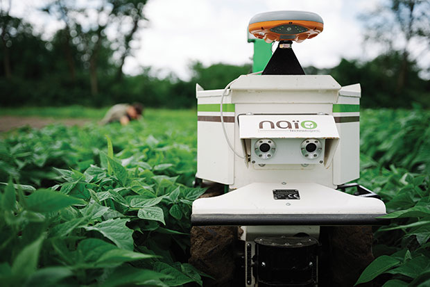
    The DINO is a one-ton farming robot made by NAIO Technologies that operates autonomously using GNSS positioning and maps for navigation. Of the 170 NAIO farming robots currently in operation, about 30% are DINOs, which are typically used on large farms.

    In 2016, NAIO and Septentrio, a manufacturer of industrial high-end GNSS technologies, began to research the integration of full GNSS solutions into NAIO’s robots.

    Today, the DINO carries a Septentrio NR3, consisting of a GNSS receiver and antenna in a single housing, which provides it with RTK centimeter-level positioning accuracy. Farmers can use the NR3 to map their fields, then attach it to the DINO to guide it.

    The DINO automates weeding within complex and quickly changing environments. NAIO plans to soon add seeding and fertilization to its robot’s capabilities.

    To operate reliably in the narrow lanes between crops, the DINO requires an accurate GNSS receiver with strong resistance to multipath and jamming.

    The safety of field hands and the protection of the crops also require the receiver to have good integrity, which is a measure of the trust that can be placed in the correctness of the information it supplies. Accuracy, robustness, and integrity are all strong suits of Septentrio’s NR3.

    While the DINO mostly operates continuously, it sometimes stops to avoid animals or humans, or for other safety reasons. A major advantage of the NR3 and other sensors that NAIO is using, is that they enable the robot to perform cold-starts very rapidly and with a stable heading.


    Machine control, guidance and automation defined

    Using GNSS guidance to aid application of fertilizer, pesticides and herbicides saves time and money. (Photo: fotokostic/iStock/Getty Images Plus/Getty Images)
    Using GNSS guidance to aid application of fertilizer, pesticides and herbicides saves time and money. (Photo: fotokostic/iStock/Getty Images Plus/Getty Images)

    The terms machine control, machine guidance and machine automation are not interchangeable.

    Machine control is a generic term that refers to the integration of positioning tools into a construction, mining or farming machine to determine its position on the Earth and relative to a desired design surface, mining task or cultivation technique.

    Within machine control, machine guidance systems display these data in the cab — assisting the machine’s operator in steering the machine and in maneuvering its implements to shape the ground, mine minerals, plant seeds or perform other related tasks — while machine automation systems directly steer the machine, achieving greater levels of precision than human operators could. The term automated machine guidance (AMG) is sometimes also used.

  • First Fix: Hunters and gatherers

    First Fix: Hunters and gatherers

    While farmers work on growing and gathering their crops in the most efficient ways possible, other people key to the agriculture industry are hunters. These hunters seek the most efficient and groundbreaking ways to carry out such tasks as plowing, planting, fertilizing, weeding and, finally, gathering.

    This month, among other machine-control applications, we focus on using GNSS technology to improve agricultural efficiency. According to research firm MarketsandMarkets, the precision farming market is estimated to be $7 billion in 2020 and is projected to reach $12.8 billion by 2025, growing 12.7% every year between.

    Factors driving growth include increasing farm mechanization in developing countries, rising labor costs, increasing strain on the global food supply, substantial cost savings associated with smart farming techniques, and government initiatives to adopt modern agricultural techniques. For a look at today’s technology, see our cover story.

    James Litton
    James Litton

    Sadly, this month we also say goodbye to a pioneer in the precision ag field. James D. Litton founded NavCom Technology in 1995 with three partners, Ron Hatch, KT Woo and Jalal Alisobhani.

    Litton’s career began at Magnavox in the early days of GPS, where he worked on the original proposal for GPS Phase I and helped develop new and advanced commercial navigation and survey receivers for both the Navy’s TRANSIT system and the Air Force’s GPS.

    In 1992, Litton opened a consulting firm, and in 1994, he and his partners founded NavCom with Litton as CEO. Under contract, NavCom developed a single-frequency WAAS-capable GPS aircraft navigation receiver.


    “His work transformed agriculture into a data-driven, technological industry.” — Brad Parkinson


    NavCom also began a relationship with Deere & Company, supporting more efficient and productive agriculture. This relationship was so successful that Deere, which recognized GNSS tech as a smart investment, purchased NavCom in 1999.

    Litton continued to lead the company and serve as part of Deere’s senior management team for eight more years.

    Among his many contributions to the GNSS field, his impact on global agriculture might well have been his greatest, according to Brad Parkinson, the original chief architect for GPS and Editorial Advisory Board member.

    “His work transformed agriculture into a data-driven, technological industry that was incredibly more efficient,” Parkinson said. “The cost savings and increases in productivity have impacted billions around the world.”

    Litton also authored several articles for GPS World.

    He died in January at his home in California with his family at his side. He was 89 years old. His family asks that donations in his name be sent to doctorswithoutborders.org.

  • Caterpillar takes command with Cat Command suite

    Caterpillar takes command with Cat Command suite

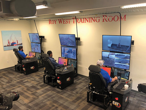
    Caterpillar’s Cat Command system enables operators, including disabled veterans, to control machines in dangerous environments from the safety of a remote command center. (Photo: Caterpillar)
    Caterpillar’s Cat Command system enables operators, including disabled veterans, to control machines in dangerous environments from the safety of a remote command center. (Photo: Caterpillar)

    Caterpillar, the world’s largest manufacturer of construction equipment, has invested in the development of autonomous vehicles for more than 30 years and has the world’s largest autonomous fleet of haul trucks.

    Its Cat Command suite of remote and semi-autonomous products for the construction industry helps increase safety, machine utilization and productivity for hauling, loading, excavating, drilling and dozing operations. They include onboard electronic and vision systems that allow machines to be controlled without anyone in the cab.

    Options include

    • The line-of-sight Cat Command Console, which is supported by a shoulder harness
    • The Cat Command Station, which can be located onsite, for line-of-sight operation, or offsite
    • The semi-autonomous Cat Command for Compaction technology, which automates soil compaction to help deliver consistent results.

    Over time, the company expects most of its machines to become compatible with its Cat Command technology.

    Here are a few examples of how construction companies are using Caterpillar technology:

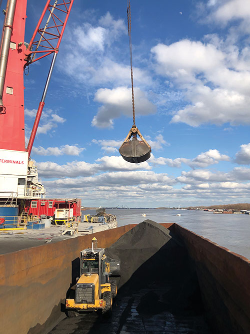
    Cargo Barges. Associated Terminals, which transloads dry bulk and general cargo in the Port of South Louisiana, uses Cat Command to remotely control its small wheel loaders and excavators, keeping its personnel off the barges.

    “It gives me a lot of peace of mind knowing that when we are doing our jobs, digging in these cargo holds in the vessels, my friend and co-worker is not operating the machine in the hold,” said Thomas Ramagos, a production manager for the company.

    Fleet Management. Beverly Companies is a landscaping, snow removal and topsoil contractor in Chicago that owns equipment ranging from bulldozers to lawnmowers. The company uses my.cat.com and other Caterpillar fleet-management tools to track all its equipment in one place, help reduce machine downtime, manage repairs and maintenance, and order parts.

    Civil Contracting. Saiia Construction Company, a civil contractor in Birmingham, Alabama, uses Cat Command to increase the safety of its employees, said Frank Montgomery, the company’s president. The material with which it deals is sometimes unpredictable, and rain events can change conditions significantly, explained Superintendent Clint Kennedy.

    A remotely controlled front loader operates inside a barge. (Photo: Caterpillar)
    A remotely controlled front loader operates inside a barge. (Photo: Caterpillar)

    Cat Command enables employees to work from an office trailer, rather than having to trudge through mud and muck to get to a piece of equipment. The controls in the seat are almost identical to the ones in the cab, Kennedy pointed out. Another employee can stand behind the chair and coach the operator.

    High-quality cameras on site enable the operator to view the whole job site, while four on the machine enable the operator to distinguish brown dirt from red dirt and rocks from sand.

    Caterpillar machines also collect massive amounts of data and transmit them over the air to the company, where they are analyzed and used in business applications.

    Customers can access these data via my.cat.com and a mobile app to better understand and manage their vehicle fleets and operations, reduce fuel consumption, and improve productivity and safety. They can also access equipment locations, engine hours, parts and service records, and inspection reports.

    According to Caterpillar, it had one million connected assets at the end of 2019, almost twice as many as three years earlier, and almost all its new construction machines are equipped with these connectivity systems. The Cat Productivity web-based suite of solutions works with Caterpillar machines of any age and brand. Of course, newer machines will provide richer data and more accurate results.

  • Trimble bridges the gap in construction projects

    Trimble bridges the gap in construction projects

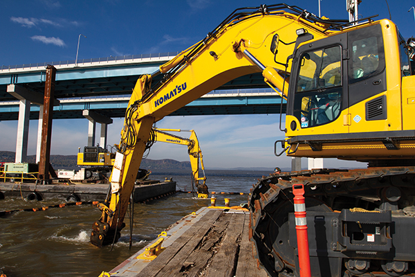
    Trimble hardware and software tracked the position and motions of the machines and displayed to the operators the position of their tools underwater. (Photo: Trimble)
    Trimble hardware and software tracked the position and motions of the machines and displayed to the operators the position of their tools underwater. (Photo: Trimble)

    The original Tappan Zee Bridge, spanning the Hudson River between Tarrytown and Nyack in the state of New York, was completed in 1955. By the 2000s, it was deemed decaying and overburdened. The collapse of Minnesota’s I-35W Mississippi River bridge in 2007 raised worries about Tappan Zee’s structural integrity.

    A new, twin cable-stayed bridge was built a few yards north of the original bridge by Tappan Zee Constructors LLC (TZC), a consortium of firms. The Left Coast Lifter — a huge crane on a barge previously used to replace a span of the San Francisco-Oakland Bay Bridge — was used to install groups of pre-assembled girders one full span at a time. Construction of the new bridge and demolition of the old one overlapped, with the entire project completed in May 2019.

    The project was huge, complex and on an accelerated schedule. “Challenges included the size of the bridge, the river’s current, tidal variations, the water’s turbidity and strong winds,” recalled Jonathan White, product manager for Trimble Civil Construction Field Solutions, Marine. Conditions were particularly challenging for bathymetric data collection before and during the project. “The low visibility in the water made it a prime situation for sonar technology to play a major role.”

    A licensed surveyor conducted a pre-dredge bathymetric survey, which was loaded into the construction software as a baseline. Trimble hardware, software and technical advice supported the demolition of the old bridge.

    “As they were beating down the bridge with the jack hammers and trying to pick up the rubble from the river with the cranes, the main challenge was to keep the 11 machines that they had updated in real time with the most accurate 3D data, so that they could keep working,” explained Nathan Keys, a geospatial engineer at Measutronics, a Trimble dealership and project lead for the Tappan Zee Bridge project.

    Rather than mount a sonar to the front of each construction barge, they used a single survey vessel to serve the machines (eight excavators and three clamshell cranes) with real-time data, using networked connections to update one machine at a time.

    Whenever a crane operator thought he was done in an area — the machine guidance display in his cab told him that he had achieved the design depth — the survey boat would verify that, and either give the operator the go-ahead to continue working or point out any spots that were still too high or too low. “That way, they would avoid having to return to an area, which costs time and money,” Keys said.

    Trimble equipment provided the positioning of the machines, tracked their motions, and visualized them, enabling the operators to “see” underwater where their bucket, grapple tool, clamshell, or other tool was operating. Trimble supported its dealer and the consortium that was executing the project, White said. “Measutronics is very well versed in the capabilities of Trimble equipment and, more broadly, marine construction workflows generally. If a piece of their equipment went down, we could swap something out and provide them with any support that they needed, and expedite that support because we knew how crucial it was with them being in the field pretty much 24/7.”

    Marine excavation. The survey vessel was equipped with a Teledyne RESON T-20 multibeam sonar and a Trimble Applanix POS MV WaveMaster for motion and position. “The eight excavators were equipped with a Trimble marine excavator guidance package, which includes a GPS receiver and angle sensors working together to give guidance to the tool, whether it is a jack hammer, a bucket or whatever,” said Keys. “They also had three clamshell cranes with rotational encoders on the wire-out drums, to keep track of the bucket’s vertical. The central piece to all this is the Trimble Marine Construction software, which takes in the data from all the sensors, including the sonar, in real time and updates the display in the cabin.”

    To install its sensors on machines, Trimble provides flexible aftermarket kits that come with weld plates. “We just point out to the customer where to weld the plates, then we will put the sensors on, run the cables to the cab, and do all the wire runs,” Keys explains. “It does not matter whether it is a Caterpillar or a Kobelco or whatever. They are aftermarket systems, so they can go on pretty much any machine.”

    This project, Keys clarified, involved only machine guidance, not automation. “We were not using any of the machines’ own sensors. We showed them where they were and then the operator would have to control it.”

    Trimble provided precise position and heading, White said. “Through a very accurate measure of where each of these sensors is installed relative to the phase center of the GPS antenna, we can determine how the machine is moving and measure that movement, so that we know exactly where the tool is relative to the position that we are getting from our satellite trilateration. It is not like the guy is sitting in the seat drinking a cup of coffee while the machine parallel parks itself. However, he is receiving a lot of information from all those sensors as to his tool’s position relative to that GPS location.”

    Keys said the machines constantly log the data and their movements while they are running. “We can go back into those log files and pull out whatever we want,” he said. “On the survey side, when they do a scan or a survey of an area, that data is captured as a 3D point cloud of what the bottom looks like, which you can import into any software to visualize and quantify the riverbed and the rubble.

    “The availability of that real-time sonar data kept those machines productive,” Keys said. “It keeps them from having to go back and do any kind of re-work.”

    White said the technology is getting more affordable and user-friendly. “That is leading us, as a manufacturer, to look for ways to help further bring it into our standardized workflows. We have been working with Teledyne on those objectives.”

    Trimble is also keen to advance the networking component, specifically to the marine sector, White added. “It is relatively new to marine construction projects. The ability to have a sonar vessel speaking to a machine, and all the machines to speak to each other, and to share a survey file is a very important objective for us.”