Category: Applications

  • SPH Engineering’s UgCS software now supports Velos UAV helicopter

    SPH Engineering’s UgCS software now supports Velos UAV helicopter

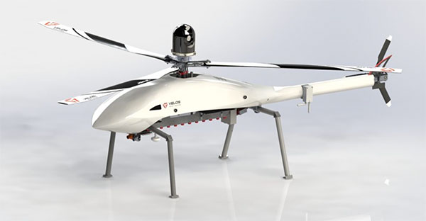
    The Velos UAV helicopter has passed field tests to become the first single-rotor helicopter supported by UgCS software, according to UgCS maker SPH Engineering. UgCS now enables Velos helicopter professionals to use Velos for photogrammetry and lidar drone surveying missions.

    UgCS is now able to support the twin-engine telemetry providing input for a UAV. Its newly created Telemetry Viewer can handle extensive telemetry from such complex drones. This allows for optimal flying of the Velos helicopter with a fully redundant twin-motor design and double key components.

    UgCS allows for the control and monitoring of one or multiple Velos helicopters on a single mission in both single and multi-operator modes.

    Photo: Velos UAV
    Photo: Velos UAV

    The field tests were initiated and conducted by GeoInspect, the first company to use c with its Velos helicopter. The new solution allows professionals to fine-tune projects, resulting in maximum performance and very high usability. One of the projects was a fully autonomous test flight with UgCS.

    “GeoInspect has been performing lidar surveys successfully with UgCS for many years,” explained Bart Zondag, GeoInspect founder. “Having started with the M600 model, UgCS is now used to support single-rotor UAVs. We have already delivered a Velos V2 with UgCS to one of our customers to the EU Nordics to perform lidar forestry surveys.”

    Learn more about the solution by joining a free Zoom webinar on March 4, 2021.

  • Verizon to acquire autonomous navigation company incubed IT

    Verizon to acquire autonomous navigation company incubed IT

    ​The acquisition will expand Verizon’s robotic capabilities to power the future of robotic automation for enterprise customers

    incubed IT logoVerizon has entered into a definitive agreement to acquire ​incubed IT​, the creator of a software platform providing autonomous navigation tools to administer, manage and optimize mixed fleets of robots in industrial settings.

    “This acquisition further demonstrates Verizon’s commitment to developing new and innovative businesses and use cases leveraging the power of 5G,” said Rima Qureshi, chief strategy officer at Verizon. “Mobile robot orchestration is a real and emerging challenge faced by enterprises today. By integrating incubed IT’s autonomous software with Verizon’s 5G platform, we will have the ability to power robotic automation at scale. This will create new opportunities for enterprise customers to better and more effectively monitor and optimize their business processes.”

    Upon closing and as Verizon continues to expand its 5G coverage, capacity and mobile-edge compute capabilities, incubed IT’s autonomous software will enable enterprise customers to gain new efficiencies as they scale their autonomous mobile robot fleets.

    Incubed IT’s award-winning software enables robots to localize and navigate autonomously and can be easily integrated into nearly any mobile robot.​ ​Their products include:

    • Smart Shuttle Navigation Toolkit:​ Transmits near real-time data to navigate autonomous mobile robots (AMRs)
    • Fleet Management Server: ​Manages AMR Fleet & Routing Operations
    • Data Monitoring and Analytics: ​Near real-time monitoring and advanced
      reporting

    “Incubed IT’s next-generation software and autonomous fleet management server are foundational components for the future of terrestrial robotics,” said Elise Neel, vice president of Verizon New Business Incubation. “When we combine incubed IT’s capabilities with the reliability, responsiveness and vast capabilities of Verizon’s 5G platform, we will enable faster, less expensive and more effective adoption of robotic automation for enterprises everywhere.”

    Incubed IT’s autonomous navigation software features include:

    • No need to specify transport paths up front
    • No predefined paths
    • Instant rerouting
    • Obstacle avoidance
    • Safe operation in areas with other vehicles and humans

    Incubed IT’s employees will join the ​Verizon New Business Incubation​ team, whose mission is to scale new automation businesses, fueled by the inherent orchestration power of 5G. The incubed IT team will continue to drive development, sales and support for its customers and suite of products across a fleet of diversified robotic partners.

    “We are proud of all the incubed IT team has accomplished to get us to this point, and we look forward to expanding on our successes and capabilities,” said Stephan Gspandl, incubed IT CEO. “By joining the Verizon team, we have the opportunity to bring our software to broader audiences and to help create the future of robotic automation.”

    The transaction is subject to customary closing conditions and is expected to close in the first half of 2021.

  • BAE Systems to develop advanced GPS chips for warfighters

    BAE Systems to develop advanced GPS chips for warfighters

    Logo: BAE SystemsBAE Systems has received a $247 million contract from the U.S. Space Force’s Space and Missile Systems Center to design and manufacture an advanced military GPS receiver and next-generation semiconductor.

    The technology will provide positioning, navigation, and timing (PNT) capabilities to warfighters so they can execute missions in challenging electromagnetic environments.

    MGUE Increment 2

    The contract is related to November’s U.S. Department of Defense contract for M-Code military GPS technology.

    The Military GPS User Equipment (MGUE) Increment 2 Miniature Serial Interface program will provide improved capabilities for size-constrained and power-constrained military GPS applications, including precision-guided munitions and battery-powered handheld devices.

    The program will focus on the certification of an advanced application-specific integrated circuit (ASIC) and the development of an ultra-small, low-power GPS module.

    Both products will work with the next-generation military M-code signal technology, which provides reliable GPS data with anti-jamming and anti-spoofing capabilities to protect against electronic warfare threats.

    “This program enables us to further develop our core M-code technology to deliver high-performance, next-generation GPS capabilities,” said Greg Wild, director of Navigation and Sensor Systems at BAE Systems. “Our M-code receiver and next-gen ASIC will enable secure and reliable military GPS capabilities in a broader range of platforms.”

    BAE Systems’ Precision Strike business has 45 years of military GPS experience and more than 1.5 million GPS devices on over 280 platforms around the world. The company is currently producing M-code GPS receivers in multiple form factors, including a low power, small form factor M-code solution.

    Additional prototypes are in development for ground, weapons and airborne mission applications, and the company’s M-code GPS products are available to U.S. allies via foreign military sales.

    Work on the program will be conducted at the company’s facility in Cedar Rapids, Iowa.


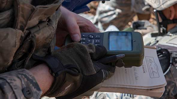
    Feature image: An Airman with the 374th Security Forces Squadron uses a Defense Advanced GPS Receiver (DAGR) to track the team’s current during a 2018 field training exercise at Camp Fuji, Japan. (Photo: Senior Airman Matthew Gilmore/U.S. Air Force)

  • GMV takes part in European GEODE military project

    GMV takes part in European GEODE military project

    Photo:Spain-based GMV is taking responsibility for integration of the GNSS/PRS receiver system for the European Union’s (EU’s) GEODE project.

    GEODE (GalilEO for EU DEfence) is the biggest Galileo application development project ever launched and a crucial and decisive step towards the development of the Galileo Galileo PRS (PRS) military user segment. GEODE is and one of the most ambitious defense cooperation projects launched under the umbrella of the European Commission’s European Defence Industrial Development Programme (EDIDP).

    Co-financed by Belgium, Germany, Italy, France and Spain, GEODE is supported by the EU with a grant of about 44 million Euros.

    GMV, part of the Spanish industrial team, will develop the GNSS/PRS receiver’s signal-processing, navigation and timing functions. GMV also participated in the Feb. 8 GEODE kick-off meeting.

    GEODE aims to boost the EU industry’s competitiveness in the highly strategic domain of military positioning, navigation, timing and synchronization (PNT) and to endow EU military forces with Galileo PRS capacity. The project will be implemented by a consortium of 30 undertakings from 14 EU countries.

    The Spanish industrial team made up by GMV, Indra and Tecnobit, takes on first-level responsibility for the complete development of the solution for naval military platforms (GNSS/PRS receiver with security module and CRPA antenna). GMV is responsible for the integration of the GNSS/PRS receiver system and, in particular, for the development of all the receiver’s signal-processing, navigation and timing functions.

    GEODE will provide the EU Industry with an even playing field in the Defense PNT market, where military GPS’s essentialness at the moment ensures U.S. industry’s supremacy. It will also reinforce EU military capability and autonomy and maximize the benefits of the Galileo program by promoting take-up of its crucial PRS service.

    Following an initial specification and standardization phase, the project will then prototype, test and qualify all the elements of a complete PRS solution:

    • PRS security modules
    • PRS receivers
    • GPS/Galileo PRS compatible controlled radiation pattern antennas (CRPAs)
    • A common and standardized test environment.

    A PRS solution for spacecraft will be also designed and prototyped. Complementarily, a PRS infrastructure will be developed to ensure the availability of the security assets necessary for operational testing.

    Military operational field testing will be organized on military naval and land platforms, RPAS, and a timing and synchronization system.

    GEODE will boost the EU industry competitiveness in the highly strategic domain of military positioning, timing and synchronization, it will foster the equipment of EU Member States’ military forces with the Galileo PRS capability, essential to reinforce their interoperability and autonomy. It also will facilitate access to complex security certified technologies and make them affordable through means of standardization and by creating the necessary critical mass.

  • Trimble SX12 total station adds features for tunneling

    Trimble SX12 total station adds features for tunneling

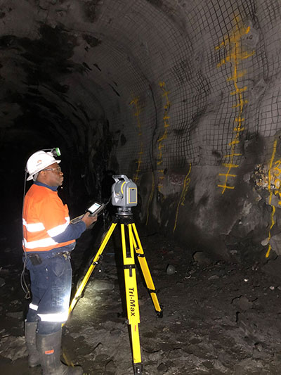
    Photo: Trimble
    Photo: Trimble

    Trimble has introduced its SX12 Scanning Total Station, the next iteration of its 3D scanning total station that provides fast and efficient data capture for surveying, engineering and geospatial professionals.

    New features include a high-power laser pointer and high-resolution camera system, expand capabilities in surveying, and complex 3D modeling. The SX12 enables enable new workflows in tunneling and underground mining, Trimble said.

    The Trimble SX12 merges high-speed 3D laser scanning, Trimble VISION imaging technology and high-accuracy total station measurements into familiar field and office workflows for surveyors.

    A new green, focusable Class 1M laser pointer — safe for viewing with the naked eye — offers high-power visibility and makes it easy to see at a distance. An improved camera system provides enhanced pointing and site documentation capabilities.

    “The new SX12 adds more features and applications to an already widely adopted, field-proven scanning total station,” said Gregory Lepere, marketing director of Optical and Imaging for Trimble Geospatial. “The addition of a premium laser pointer completes the picture for surveyors wanting an instrument that can operate as an everyday high-end total station with the added value of scanning and imagery.”

    Tunnels and underground mining

    The Trimble SX12 allows users to quickly and easily operate with common survey workflows, including new versions of Trimble’s field and office software.

    With Trimble Access 2021 Field Software, users can harness the full potential of the Trimble SX12, whether performing accurate measurements or comparing 3D scanning as-built data in the field. The combination is designed for infrastructure projects such as utilities, roads, rail, water, transportation and telecom.

    The laser pointer enables new applications for laser-guided drilling and excavation guidance, rock bolt and blast hole set out, and as-built verification for underground tunnel and mine construction.

    By integrating rich data from the Trimble SX12 into intuitive office workflows, Trimble Business Center version 5.40 enables users to quickly create complete customer deliverables. With its enhanced point-cloud management, eCogAI automated information extraction, and interoperability to leading CAD and GIS packages, the solution empowers users to exceed even the toughest client demands.

    The combination also enables the capture of tunnel point clouds for as-built comparison, automated tunnel extraction routines and detailed 3D mesh inspection resulting in intuitive reporting deliverables for construction verification.

    “Tunneling projects are highly dependent on accurate positioning to precisely control equipment and track progress in difficult underground construction environments,” said Boris Skopljak, marketing director of Monitoring and Tunneling for Trimble Geospatial. “The combination of the SX12 and new software workflows, simplifies the capture of site conditions, enabling tunneling and mining surveyors to make accurate and informed decisions without the complexity and additional cost of multiple systems.”

  • Sokkia releases two robotic total stations for survey, layout

    Sokkia releases two robotic total stations for survey, layout

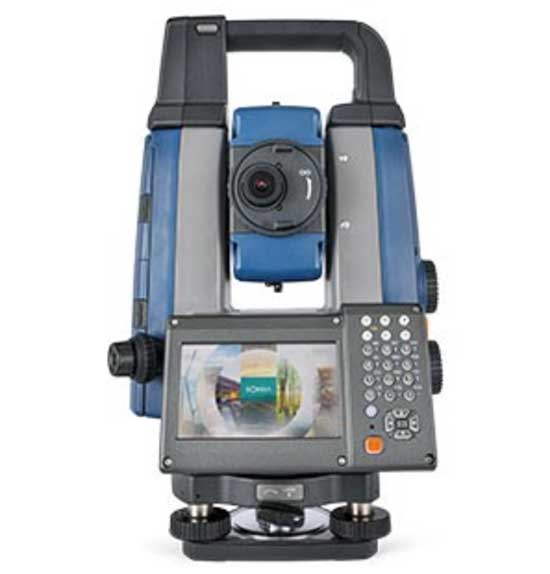
    Photo: Sokkia
    Photo: Sokkia

    Sokkia has launched two robotic total stations designed to improve job site productivity: the iX-1200 and iX-600.

    According to Sokkia, the total stations, designed as a part of a full workflow solution, are professional-level positioning tools for survey and layout in the building construction and infrastructure trades. They’re engineered for integration with field controllers, software and GNSS receivers.

    In addition, advanced users can take measurements in almost any environment while switching to the most appropriate technology — total station measurement integrated with GNSS measurement — through an optional upgrade to Hybrid Positioning technology, Sokkia said. The stations also can be seamlessly integrated into BIM workflows.

    “The high-performance technologies incorporated into the design provide increased prism-tracking strength,” said Ray Kerwin, director of global product planning. “Through a combination of optical sensing and ultrasonic motors, UltraTrac technology helps users stay locked onto the prism — and productive with less down time resulting from the need to reacquire prism lock — even in dynamic job site conditions. The system also features the RC-PR5A remote controller option used on the prism pole so the user can quickly and simply reestablish the connection between prism and total station.”

    The total stations, available in multiple accuracy models, can be used with the SHC6000 field controller and GeoPro or MAGNET Field software for optimal performance, Sokkia added.

  • LORAN-5G: Paper envisions new use for venerable tech

    LORAN-5G: Paper envisions new use for venerable tech

    Image: KENGKAT/iStock/Getty Images Plus/Getty Images
    Image: KENGKAT/iStock/Getty Images Plus/Getty Images

    A new paper by two Qualcomm engineers imagines restructuring Loran technology to more easily incorporate timing signals into telecommunication systems.

    The paper, titled simply “LORAN-5G,” was authored by Guttorm Opshaug and Dave Tuck. It envisions moving away from legacy pulsed signals to a more continuous wave form which would allow significantly lower power transmissions.

    According to Opshaug, “Another big advantage that may not be as apparent, is the built-in orthogonality in the signal structure of OFDM. This means that a receiver would be able to detect very weak signals from distant towers at the same time as receiving signals from a very strong close tower. Such robustness towards near-far effects is critical for terrestrial navigation use.”

    Another change would be a marked increase in the capacity of the Loran data channel to more than 2.6kbps. “This could open opportunities for additional service options and/or reduce latency of existing ones,” according to Tuck.

    UrsaNav CEO, Charles Schue, expressed great interest in Qualcomm’s paper. UrsaNav is a long-time provider of Loran equipment and consulting. “The intersection of PNT and communications discussed in the Qualcomm paper is exactly what is needed to ensure that PNT systems evolve and stay relevant,” he said. “In fact, we build our software defined transmitter and receiver solutions to specifically include the ability to produce and use these types of signals.” A Cooperative Research and Development Agreement between UrsaNav and the Department of Homeland Security demonstrated these type of potential upgrades in 2012.

    This paper is the first publicly released effort examining the use of Loran technology to support 5G telecommunications. The general concept was discussed in a 2016 paper by the Alliance for Telecommunications Industry Solutions’ (ATIS) Synchronization Committee. Based on the paper, ATIS in 2017 encouraged members of Congress to pass legislation that would become the National Timing Resilience and Security Act of 2018 (NTRSA).


    There are tradeoffs. Opshaug and Tuck’s proposal would replace the legacy Loran standard signal with a new one.


    “I was in the midst of developing proposals for the 3GPP standards organization when I first heard about the NTRSA,” said Opshaug. “5G seemed like exactly the kind of critical infrastructure that could benefit from a backup timing solution.”

    “We wanted to bring some of the ideas used to develop 5G position and timing to Loran,” said Tuck. “Using Loran as the timing synch could enable 5G to improve overall infrastructure resilience.”

    Yet, as with most things, there are tradeoffs. Opshaug and Tuck’s proposal would replace the legacy Loran standard signal with a new one. This would require redesign of receivers and some transmitters. The proposal could support denser deployments to further improve resiliency.

    “The new signals seem incompatible with existing receivers and Loran networks,” according to Professor Jiwon Seo of South Korea’s Yonsei University. South Korea is upgrading its Loran-C network to the eLoran standard. The new South Korean system will be compatible with neighboring Russian and Chinese Loran systems, so users will be able to benefit from signals anywhere in East Asia. Until 2010 signals from the U.S. Loran system cooperated with these networks as part of the Far East Radionavigation Service (FERNS).

    Navigation expert Logan Scott is intrigued by the proposal but observes that more work needs to be done. “This is an interesting waveform,” he said, though he had questions about the propagation channel, antennas, and possible distortion.

    The authors acknowledge that much more needs to be done, including better determining timing and positioning accuracy.

    Yet they and others see potential in combining the very different phenomenologies of low frequency, 100KHz Loran and 5G telecommunications which typically operate in the gigahertz range.

    Opshaug and Tuck’s paper LORAN-5G can be accessed here.

  • Vodafone tests remote centimeter-level tracking tech

    Vodafone tests remote centimeter-level tracking tech

    New tech can track vehicles, drones and cargo remotely within centimeters — key to safe adoption of autonomous vehicles, flying objects and machinery

    Vodafone logoVodafone has successfully used new precision positioning technology to remotely track a vehicle to within 10 centimeters of its location, an improvement of more than three meters compared to its current system.

    Vodafone is working in partnership with Sapcorda, using Vodafone’s global internet of things (IoT) platform, which has  118 million connections worldwide.

    Vodafone expects the technology to enable applications that warn autonomous trucks of obstacles, tell first responders the position of critical medical drones, and give operators the precisely location of important cargo.

    Pinpoint accuracy is critical to the acceptance and mass adoption of autonomous vehicles on the road and in factories, airports, dockyards and any site where machines are in motion. A matter of centimeters can be crucial to ensuring the safety of passengers on a driverless bus, or knowing the precise location of a medical drone. a

    The tracking technology will also allow an autonomous truck to mind other road users, including cyclists, whose e-bikes can automatically transmit their position and intended direction of travel.

    “We might not be able to locate a needle in a haystack yet, but we are getting close,” said Vodafone Business Platforms and Solutions Director Justin Shields. “What we can do now is take new digital services like this one, integrate it with our global IoT platform and fast networks, and offer it securely at scale to many millions of customers.

    “Our in-building 5G and IoT services already allow manufacturing plants, research laboratories and factories to carry out critical, and often hazardous, precision work with robots. Now we are applying the same levels of accuracy to the outdoor world.”

    Vodafone is redefining its network and technology on a Telco as a Service (TaaS) model. It makes key network capabilities available through common APIs in a cloud platform to deliver new software, video and data applications at scale, in addition to gigabit-capable connectivity.

    Vodafone said the TaaS model will benefit large enterprises, improving their ability to  locate critical assets, precisely align machines such as driverless trains at platforms, and let farmers, airports, and fleet operators know the exact whereabouts of their autonomous vehicles.

    Vodafone IoT-enabled vehicles, machinery and devices — when linked with Sapcorda’s comprehensive network of GNSS receivers and augmentation technology — improves location accuracy by correcting for things like the curvature of the earth, atmospheric delays and clock differences of global positioning satellites. This offers corporations hyper-precise positioning that they can use to ensure a safe environment for their employees, their customers, the public and their machines.

    Combined with video and onboard diagnostics, the technology will also allow vehicle operators to carry out accurate location-sensitive remote inspections and even pause machines such as grass cutters on public footpaths when they encounter people.

    PPP-RTK method. Vodafone is adopting the precise point positioning – real-time kinematics (PPP-RTK) method with ground-level GNSS stations to achieve the best error correction. GNSS signals are processed and GNSS corrections are sent out to enhance the position accuracy of the vehicles receiving them.

    Vodafone is able to equip any number of vehicles with an in-built IoT SIM, and deliver the positioning data at speed using its gigabit-capable networks.

    Vodafone recently put this to the test by tracking in real-time the exact lane that vehicles were traveling in during a combined journey of more than 100 kilometers in varying weather conditions.

    Sapcorda provided the data feed, which enabled the GNSS signal to be corrected, to deliver the critical-level of positional accuracy. A precise positioning service complements the existing asset tracking and fleet telematics solutions already provided by Vodafone Business for enterprise customers across 54 countries.

  • Raytheon Intelligence & Space delivers 3,000th GPS receiver

    Raytheon Intelligence & Space delivers 3,000th GPS receiver

    Raytheon Intelligence & Space, a Raytheon Technologies business, delivered its 3,000th MAGR 2000-S24 GPS system to the U.S. Air Force. The MAGR2K is a secure, resilient GPS receiver that allows the warfighter to navigate the battlespace with protection against interference and jamming.

    The MAGR2K is an upgrade to the legacy miniaturized airborne GPS receivers and is in service aboard 20 types of fixed-wing and rotary-wing platforms from Department of Defense and Foreign Military Sales customers.

    “In the battlespace, disruptions to navigation are not an option,” said Eric Ditmars, vice president of Secure Sensor Solutions at RI&S. “Our MAGR2K GPS receivers enhance GPS acquisition and performance ensuring military forces reliable and assured GPS data they can act on. Delivery of the 3,000th unit is a significant milestone for our team.”

    Raytheon Intelligence & Space continues to upgrade the MAGR2K technology to stay current with the evolving battlespace. Development is underway for the MAGR-2K-M, which uses the company’s M-code technology.

    The first production readiness units are undergoing platform integration on the U.S. Air Force’s B-2 platform.

    B-2 Spirit multi-role bomber capable of delivering both conventional and nuclear munitions. In December 2017, the Air Force completed a series of successful flight tests of M-code GPS using a Raytheon Company receiver on board a B-2 Spirit at Edwards Air Force Base, California. (Photo: U.S. Air Force/Bobby Garcia)
    B-2 Spirit multi-role bomber capable of delivering both conventional and nuclear munitions. In December 2017, the Air Force completed a series of successful flight tests of M-code GPS using a Raytheon Company receiver on board a B-2 Spirit at Edwards Air Force Base, California. (Photo: U.S. Air Force/Bobby Garcia)
  • DSI to host 2021 Assured PNT Summit in April

    Logo: Defense Strategies Institute

    The Defense Strategies Institute’s (DSI) Assured Positioning, Navigation & Timing (PNT) Summit will take place April 14-15 at the Mary M. Gates Learning Center in Alexandria, Virginia.

    According to DSI, the event will bring together members of the military services, Department of Defense (DoD), federal government, industry and academia in a “town hall” style forum to discuss how important GPS and space-based PNT systems are to the overall resilience of the warfighter, as well as critical infrastructure across the United States and abroad.

    The 2021 Assured PNT Summit also will offer senior-level insight into how the U.S. military has been a leader in integrating PNT into its everyday operations and how such capabilities have become vital to the military’s ability to shape the global arena, deter aggression, and fight and win wars.

    Confirmed speakers for this year’s event include William Nelson, SES, director, APNT CFT, Army Futures Command; Brig. Gen. Heather L. Pringle, USAF, commander, Air Force Research Laboratory; Anthony C. Smith, SES, director, C3I, DoD CIO; Richard De Fatta, SES, director, U.S. Army Space & Missile Defense Center of Excellence; Cordell “Del” DeLaPena, SES, program executive officer for Space Production Space & Missile Systems Center, USAF; Harold W. Martin III, SES, director, National Coordination Office for Space-Based Positioning, Navigation and Timing; and Col. Jason Joose, USA, chief of staff/APNT signature effort lead, Army Futures Command.

    A number of topics will be covered at the 2021 Assured PNT Summit, including:

    • Leading current DoD initiatives toward integrating new PNT capabilities to help the Warfighter remain resilient in a dynamic threat environment;
    • Synchronizing PNT, navigation warfare and space capability development efforts across the Army to help reduce key capability gaps;
    • Delivering resilient, affordable and sustainable space capabilities such as modernized GPS to enhance warfighter superiority;
    • Providing alternate PNT for potential GPS-denied environments;
    • Accelerating the implementation of cutting-edge Air Force research projects such as NTS-3 GPS Satellite to provide the most value to the warfighter;
    • Developing critical PNT-related products to enable a Soldier’s PNT capabilities in all warfighting domains;
    • Overseeing the collection of GPS-related information from multiple federal agencies in an effort to improve and maintain space-based PNT capabilities;
    • Advancing efforts to provide GPS protection for all naval air platforms; and
    • Detailing the Department of Homeland Security plan to test the vulnerabilities of critical infrastructure systems, networks and assets if PNT services were to be disrupted or manipulated.

    Register for the event here.

  • GEODE begins work on military user equipment for Galileo

    GEODE begins work on military user equipment for Galileo

    A crucial step toward the development of the Galileo Public Regulated Service (PRS) military user segment took place Monday, Feb. 8, with the kick-off meeting in Brussels of the GEODE (GalilEO for EU DEfence) project, according to a press release from FDC.

    GEODE is the biggest Galileo application development project ever launched.

    Sponsored by Belgium, Germany, Italy, France and Spain — contributions should exceed 82.7 million euros — GEODE is supported by the EU with a grant of about 44 million euros. The ambitious defence-cooperation project is under the umbrella of the European Defence Industrial Development Programme (EDIDP) of the European Commission.

    GEODE will establish the framework for developing the Galileo PRS user segment for defense applications. At kick-off, the project involved 30 companies and organizations from 14 EU Member States: Belgium, Czech Republic, Estonia, Finland, France, Germany, Greece, Italy, the Netherlands, Poland, Portugal, Spain, Sweden and Romania.

    The GEODE Roadmap

    National defense organizations — in close cooperation with industry — have defined a roadmap for the Galileo PRS military user segment development, beginning with a specification and standardization phase. GEODE will prototype, test and qualify

    • seven PRS security modules developed from various technologies
    • nine PRS receivers (including two server-based variants)
    • four GPS/Galileo PRS-compatible anti-jamming controlled radiation pattern antennas (CRPA).

    A common and standardized test environment will be developed as well as a PRS infrastructure to ensure the availability of the security assets for operational testing.

    Finally, military operational field testing will be organized on military platforms (naval, land and drones) and timing and synchronization systems in (at least) Belgium, Czech Republic, France, Germany, Greece and Romania.

    A PRS solution for spacecraft will also be designed and prototyped.

    Beyond paving the way for the equipment of EU Member States defense forces with Galileo PRS, the military user segment that is developed, tested and certified under GEODE is planned to be available for export to other countries that have the necessary PRS security agreements with the EU.

    The GEODE project will be completed in 2026.

    Plans are for GEODE to

    • boost EU competitiveness in the highly strategic domain of military positioning, timing and synchronization.
    • foster the equipment of EU Member States’ military forces with Galileo PRS capability, essential to reinforce their interoperability and autonomy.
    • facilitate access to complex security-certified technologies and make them affordable through means of standardization and by creating the necessary critical mass.

    In brief, the project will bolster EU Member States’ military capability, create business opportunities for the EU industry in the field of military application of satellite navigation, and maximize the benefits of the Galileo programme by energizing the adoption of its PRS service in all EU Member States and beyond.

    Background on GEODE

    This project has received funding from the European Defence Industrial Development Programme (EDIDP) under grant agreement No 039.

    The GEODE industrial consortium is led by FDC and comprises the major industry players of the field: Airbus Defence and Space, Antwerp Space, Cy4gate, Diehl Defence, Elettronica, Fraunhofer Institute for Integrated Circuits IIS, GMV Aerospace and Defense, Indra Sistemas, Safran Electronics and Defense, Leonardo, Siemens Aktiengesellshaft, Orolia, Tecnobit, Telespazio, Thales Alenia Space Italia, Thales AVS France, Thales SIX GTS France, accompanied with 12 other EU companies acting as subcontractors (c.f. picture hereafter).

    The GEODE project is developed in the context of the European Radio-navigation Solution (EURAS) project of the Permanent Structure Cooperation (PESCO). The EURAS project aims at promoting the development of EU military positioning, navigation and timing) capabilities and future cooperation taking advantage of Galileo and the PRS.


    Feature photo: U.S. Army
  • Bluesky to create 3D map of Northern Ireland’s coastline

    Bluesky to create 3D map of Northern Ireland’s coastline

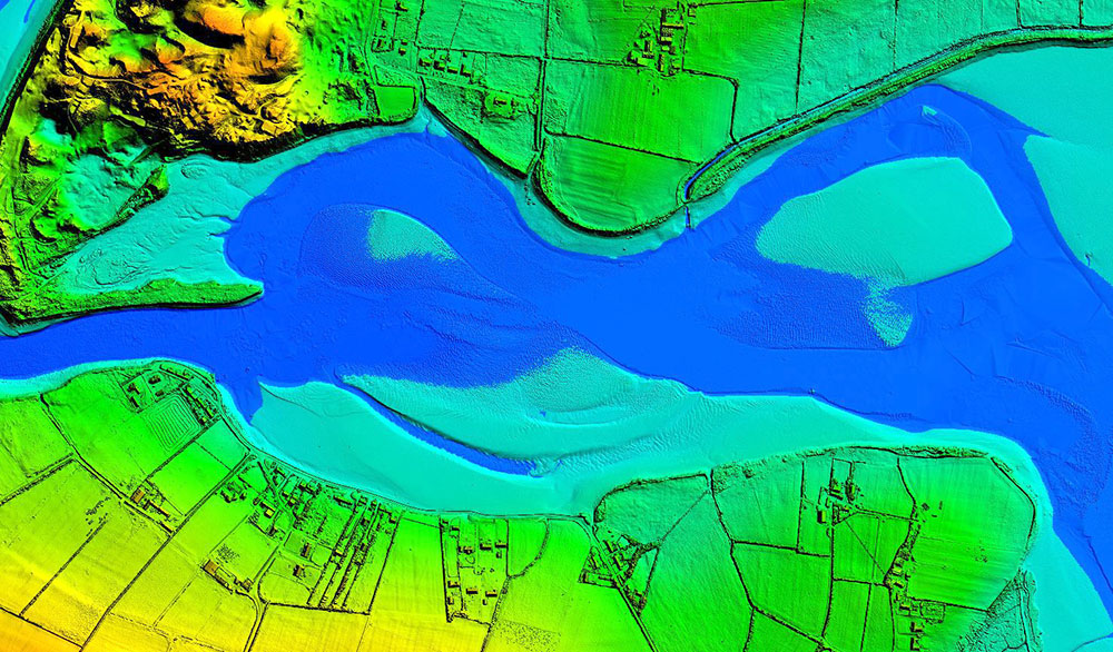
    Dundrum Bay on the coast of Northern Ireland is captured by a mapping airplane in a project to document climate change effects. (Photo: DAERA/Bluesky)
    Dundrum Bay on the coast of Northern Ireland is captured by a mapping airplane in a project to document climate change effects. (Photo: DAERA/Bluesky)

    Bluesky International will use aircraft-mounted lidar sensors and laser scanners to create a highly detailed 3D map of the whole of the Northern Ireland coastline.

    Working on behalf of the Department of Agriculture, Environment and Rural Affairs (DAERA), the lidar survey will be used to create the first complete baseline. The baseline will underpin recording of coastal change and help identify the rate at which the coastline is changing as a result of climate change.

    In addition to the lidar data Bluesky will simultaneously capture high detailed aerial photography which will be processed to produce to a fully orthorectified, 10-centimeter-resolution database.

    The Bluesky data will form part of the wider Northern Ireland 3-dimensional coastal survey. The survey will extending into the marine environment with a satellite-derived bathymetric survey and a pilot bathymetric lidar survey. Together, the surveys will inform the development of future coastal management policies.

    “The Northern Ireland coast is a hugely valuable resource which is currently facing increasing pressure from climate change,” said Joanne Hanna, senior scientific officer within the Marine and Fisheries Division of DAERA. “Sea-level rise, in combination with an increase in extreme storm events, is resulting in greater energy impacting our coastlines, altering coastal processes and accelerating change.

    “Despite the importance and the value of this coastline, the nature and scale of the issues arising from coastal change and sea-level rise are currently not known and there is limited and insufficient baseline data available,” Hanna said. “The coastal lidar survey carried out by Bluesky will provide scientifically robust baseline data which will enable decision makers and coastal managers to make informed decisions and devise solutions and appropriate management to the problems currently facing our coastline.”

    Bluesky will undertake the specialist survey using a fixed wing manned aircraft and will fly the 763 kilometres of Northern Ireland coastline capturing height measurements of both the underlying terrain and any surface features at a resolution of better than 16 points per metre. This data will be used to create highly accurate 3D digital terrain and surface models (DTM, DSM) with a spacing of up 25 centimetres.

    The Bluesky datasets will be supplied ready for use in a range of geographical information system (GIS), desktop mapping and other specialist software packages and will be compatible with other DAERA datasets including Ordnance Survey mapping.

    Photo: DAERA/Bluesky
    Photo: DAERA/Bluesky