Category: Applications

  • NGS releases beta tool for obtaining geodetic information

    NGS releases beta tool for obtaining geodetic information

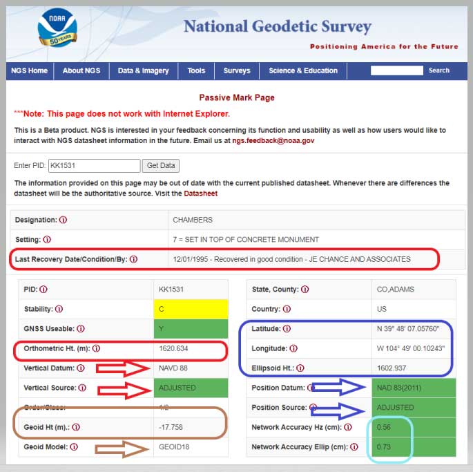
    NGS has developed a new beta tool for obtaining geodetic information about a passive mark in their database. This column will highlight some features (available as of Oct. 5, 2020) that may be of interest to GNSS users. It provides all of the information about a station in a more user-friendly format. The box titled “Passive Mark Lookup Tool” is an example of the webtool. The tool provides a lot of information so I have separated the output of the tool into several boxes titled “Passive Mark Lookup Tool — A through D.”

    I will highlight several attributes that I believe will be very useful to users, especially users of leveling-derived and GNSS-derived orthometric heights. I’ve highlighted several attributes in the box titled “Passive Mark Lookup Tool — A” that are important to users such as published coordinates, their datum and source, Geoid18 value, GNSS Useable, and the date of last recovery. All of these values are available on a NGS datasheet but, in my opinion, this provides the information in a more user-friendly format.

    Passive Mark Lookup Tool — A

    (https://beta.ngs.noaa.gov/datasheets/passive-marks/index.html)

    Image: National Geodetic Survey
    Image: National Geodetic Survey

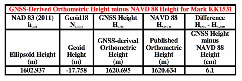
    One calculation that the user can easily compute for marks that have been leveled to and occupied by GNSS equipment, is the difference between the published leveling-derived orthometric height and the computed GNSS-derived orthometric height. This may indicate that the mark has moved since the last time it was leveled to or that its height coordinate has been readjusted since the creation of the published geoid model.

    The table below provides the calculation using the data from the box titled “Passive Mark Lookup Tool — A.” The calculation [HGNSS = hGNSS — NGeoid18; Difference = HGNSS — HNAVD 88] has been described in several of my previous columns (this one, for example).
    Data: National Geodetic Survey
    Data: National Geodetic Survey

    In this example, the difference between the GNSS-derived orthometric height and the Published NAVD 88 height is 6.1 cm. NGS is looking for comments on this beta webtool so if users would like this computation added to the tool, they should send a comment to NGS using the link provided on the site (This is a beta product. NGS is interested in your feedback concerning its function and usability as well as how users would like to interact with NGS datasheet information in the future. Email us at [email protected].) So, the user should ask the question, did the station move since the last time it was leveled?

    Another attribute that would be nice to be part of this tool is which station was used to create the hybrid geoid model. As of Oct. 5, 2020, users have to go to the Geoid18 webpage to get the information. The Excel file and shapefiles provide whether the station was used to create the Geoid18 model. In the case of this example, KK1531, CHAMBERS, the mark was not used in the creation of Geoid18 so NGS felt that the station may have moved and/or the GPS on Bench Mark residual was large relative to its neighbors. See NGS’s technical report on Geoid18 for more information on the creation of Geoid18. The GPS on Bench Mark residual analysis was described in several of my previous columns (see “The differences between Geoid18 values and NAD 83, NAVD 88 values” and “NGS 2018 GPS on BMs program in support of NAPGD2022 — Part 6” for examples).

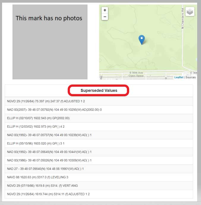
    The webtool provides a map depicting the location of the station, photos (if available), and previously published, superceded values of the mark. See the box titled “Passive Mark Lookup Tool — B.”

    Passive Mark Lookup Tool — B

    Image: National Geodetic Survey
    Image: National Geodetic Survey

    In the example of Chambers, KK1531, no photos were available. It would be helpful if a user would provide photos to NGS when visiting this station. (Note: NGS has a webtool for users to submit recovery information about a mark as well as to provide current photos of the station.) The new Passive Mark webtool also provides information about the survey projects that the mark has been involved in such as leveling and GNSS projects.

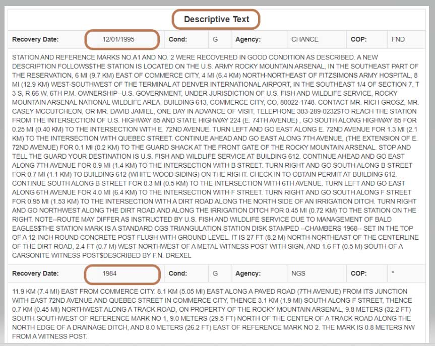
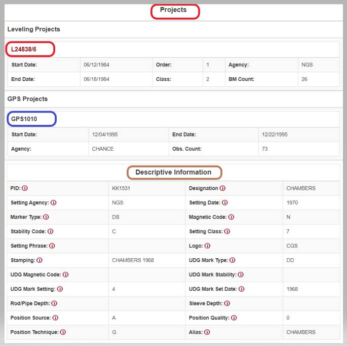
    In this example, mark CHAMBERS was leveled to in a 1984 first-order, class 2 leveling project (Leveling Line number L24838/6) and, in 1995, the mark was part of a GNSS project (GNSS Project GPS1010). It also provides all the descriptive text and recovery information (See boxes titled “Passive Mark Lookup Tool – C” and “Passive Mark Lookup Tool – D”).

    Passive Mark Lookup Tool — C
    Data: National Geodetic Survey
    Data: National Geodetic Survey

    Passive Mark Lookup Tool — D

    Image: National Geodetic Survey
    Image: National Geodetic Survey

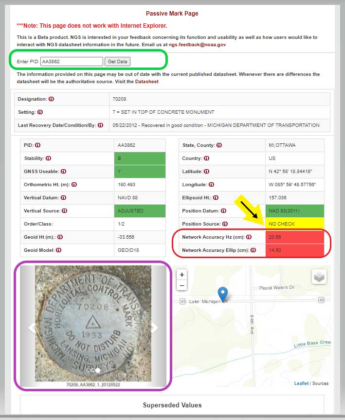
    I want to highlight a few other attributes of this webtool. The station, PID AA3862, has an interesting attribute that users should take note of; that is, the NAD 83 (2011) position source is NO CHECK. See box titled “Passive Mark Page for PID AA3862.”

    This means that the mark’s NAD 83 (2011) coordinates were determined without redundant observations. This is not a good survey practice but there are times that a project may contain check observations for some purpose or, more likely, the mark did contain other GNSS vector but they were rejected in the final adjustment. Either way, a good survey practice would be for users to verify the coordinates of these marks before using them.

    Passive Mark Page for PID AA3862

    Data: National Geodetic Survey
    Data: National Geodetic Survey

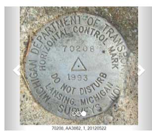
    As previously mentioned, the tool provides the location of the station on a map and photos if they are available. This is a really nice feature for anyone searching for the mark. The map can be enlarged as well reduced by clicking on the box. See boxes titled “Passive Mark Page for PID AA3862” and “Photos of Mark PID AA3862.” The box titled “Photos of Mark PID AA3862” provides all three photos of mark PID AA3862.

    Photos of Mark PID AA3862
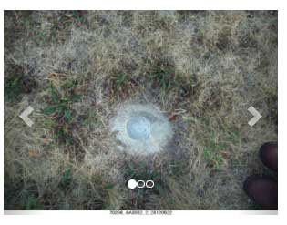
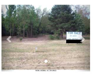
    Photo: National Geodetic Survey
    Photo: National Geodetic Survey
    Photo: National Geodetic Survey
    Photo: National Geodetic Survey

    Photo: National Geodetic Survey
    Photo: National Geodetic Survey

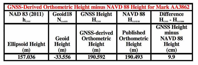
    It should be noted, according to the Geoid18 GPS on BMs dataset that users can download, this station, AA3862, was not used in the creation of Geoid18. The table below provides the difference between the GNSS-derived orthometric height and the published NAVD 88 height.

    In this example, the difference between the GNSS-derived orthometric height and the published NAVD 88 height is 9.9 cm. Also, the webtool provides the network accuracy values for the station. In this example, the horizontal network accuracy is 20.65 cm and the vertical network accuracy value is 14.50 cm (see highlighted values in box titled “Passive Mark Page for PID AA3862”). These are very large network accuracy values. This should be a flag to anyone that is using this station as control.
    Data: National Geodetic Survey
    Data: National Geodetic Survey

    As I previously mentioned, as a beta site, users should verify all information from the site. NGS is requesting feedback on this tool so they can improve it and make it an operational webtool. I encourage everyone to access the tool and check out a few of their favorite marks, and then send an email to NGS informing them of what you like, what you would like to change, and what you would like to see added to the tool.

    NGS is releasing this tool as a beta product to get feedback from users. As NGS states in the heading of the tool, they are interested in your feedback concerning its function and usability as well as how users would like to interact with NGS datasheet information in the future. Email NGS at [email protected].

    One last item that may be of interest to GNSS users is that NGS, working with the University Corporation for Atmospheric Research (UCAR), developed another online GNSS lesson (see box titled “New GNSS Lesson by NGS and UCAR”). These lessons are free but users must sign up to access the website and lesson.

    New GNSS Lesson by NGS and UCAR

    Image: National Geodetic Survey
    Image: National Geodetic Survey
  • GPS technology will continue to transform agriculture

    GPS technology will continue to transform agriculture

    By Al Savage, John Deere

    Headshot: Al Savage
    Al Savage, John Deere

    While GPS technology originally started as a product of the space race, it has transformed in recent decades to be used in a variety of different industries. Its positioning and navigation capabilities make many everyday tasks easier to achieve. One industry that has continuously benefitted from this technology is agriculture.

    The world’s population is expected to reach nearly 10 billion people by 2050, effectively increasing global food demand by 50%, according to the United Nations. To meet these demands, global agricultural productivity will need to increase by 1.75% a year.

    Currently, productivity is only growing at an average rate of 1.63%, according to the Global Harvest Initiative. Precision agriculture and advanced technologies, such as automation, computer vision, artificial intelligence (AI) and machine learning are already on the farm helping farmers meet this demand, and GPS technology plays an especially significant and transformative role in making this happen.

    Game-Changer

    The development of automated driving and self-driving tractors has changed the game for farming by allowing technology to drive the machines with great accuracy, while farmers focus on other value-added tasks.

    Over time, that technology further developed in conjunction with other technology on the farm, such as GPS. Having a reliable way to keep equipment from running over crops is incredibly important to farmers.

    The GPS technology we use at John Deere is accurate within centimeters and complements the computer vision and sensors within the tractors with precise positioning in the field. This allows the farmer to drive faster without running over and damaging the crop. It also means farmers no longer cover the same ground twice.

    Other technology has also been installed on farming machines to provide added value, especially when paired with GPS. When used alongside sensors, GPS offers the potential to enable real-time data collection. Sensors throughout the field let farmers know things such as where each seed was planted or environmental conditions while spraying nutrients on their crops.

    Historical data from the farmer and garnered through the technology are turned into maps that, when combined with real-time information from the sensors, enable farmers to have even more accurate and precise information about what is happening next in the field, to ultimately optimize operations. This is critical as almost every job that gets done on the farm has to be completed in short time windows.

    Spatial intelligence provides a more vivid representation of what is happening in the field at all times so the farmer can make real-time decisions and plan for the future.

    Tasks such as tilling, planting, spraying and harvesting are easier when farmers have a more precise way to track their position. GPS technology, working in conjunction with computer vision cameras and sensors, allows crops to be distributed more evenly across a field and enables seeds to be planted at exactly the correct spacing and position to maximize yield.
    All of these tasks boost productivity and sustainability on the farm by providing farmers with the data to make informed, sustainable decisions.

    Photo: John Deere
    Photo: John Deere

    Machines Talking to Each Other

    Technology on farms has evolved to the point where machines can wirelessly communicate to each other in the field. This concept, known as machine-to-machine (M2M) communication, is also linked closely to GPS technology. Enabling machines to know where in the field another machine is and what work it has done in real time means the machines work as a team to get the job done in the most efficient way possible with no overlap. Coordination among machines helps farmers avoid redundant effort and the overuse of valuable inputs, which allows for more efficient use of resources and unlocks the potential of automation.

    As the agriculture community continues to work to meet the rising demands for food, fuel and fiber, GPS technology will play a key role to help farmers make more food more efficiently, sustainably and with greater consistency in results. This not only benefits the farmer’s business, but it impacts every single person in the world.


    Al Savage is the StarFire Network manager at John Deere.

  • Research Roundup: Navigation in urban environments

    Research Roundup: Navigation in urban environments

    Image: Moncherie/E+/Getty Images
    Image: Moncherie/E+/Getty Images

    Of the hundreds of papers researchers presented this year at the Institute of Navigation’s annual ION GNSS+ conference, which took place virtually Sept. 21–25, the following three focused on navigation in urban environments. Papers are available at www.ion.org/publications/browse.cfm.

    Low-Cost Single-Frequency PPP System

    Featuring multi-constellation global availability, fast convergence and continuous navigation solutions, Instant PPP (IP3) was developed as an ideal precise positioning solution for mass-market applications in urban environments. The low-cost single-frequency PPP system demonstrates 50-cm accuracy in open-sky and suburban environments, and is further enhanced to support precise positioning in urban environments. The IP3 library is uniquely designed and enhanced. For instance, the instant receiver velocity based on the Doppler observations and the coordinate changes calculated from the carrier-phase differences between two consecutive epochs are integrated for the one-step prediction of the receiver positions in the Kalman filter.

    Meanwhile, the weight of carrier phase, pseudorange and Doppler observations are smartly tuned as a function of signal-to-noise ratio (SNR) respectively. Additionally, quality control adapts to different scenarios, such as open-sky or urban environments. The receiver clock drifts for different constellations are specifically modelled in the velocity estimation to increase the degrees of freedom, which further enhances the solution availability in these extreme challenging situations.

    To evaluate the IP3 library in urban environments, real-time vehicle-based field tests were carried out with an IP3 evaluation kit in Calgary, Canada. Results indicate the IP3 library can provide 50-cm accuracy in suburban areas with 100% solution availability. In an urban environment with numerous high buildings, the positioning root-mean-square error (RMS) of IP3 degrades to meter level while the solution availability remains 100%. IP3 can provide precise positioning solutions with low-cost GNSS receivers even in urban environments.

    Citation. Hongzhou Yang, Fei Liu and Yang Gao, Profound Positioning Inc., Canada, “Precise Positioning into Urban Environments: A Low-Cost Single-Frequency PPP System.”

    A Sub-Meter Real-time Positioning Service for Smartphones

    A real-time positioning service for smartphones that meets a target threshold of 50 centimeters in urban environments is evaluated. The evaluation is possible through the Flamingo service, an API library for smartphone developers that enables higher accuracies than standard Google location services. The API is offered in a format that simply replaces Android location, streamlining its integration into new and existing applications that require better positioning. The service provides reference station infrastructure and correctional data products through a modified version of traditional NTRIP services. Duty cycling, low-quality clocks and high RF interference are common in a smartphone, so pre-filtering algorithms have been designed and calibrated to reject and de-weight poor measurements.

    Based on proximity to a local base station, the service decides whether to use RTK or PPP-like processing. Performance is assessed on positioning accuracy, reliability and availability. Different operational environments are tested, such as pedestrian navigation in a congested area, and cycling scenarios. These are chosen to closely correspond to various applications. Rather than proving ideal test conditions and post-processing to optimize performance, the study focuses on realistic, real-time processing inside a smartphone.

    Results are collected through a simple logging app that uses the Flamingo API. A target is set for 50 cm or better accuracies, where current smartphone positioning is within only a few meters. This enables mass-market location services to be applied in new markets such as augmented reality, lower accuracy surveying, GIS asset collection, and navigation assistance applications.

    Citation. Joshua Critchley-Marrows, William Roberts, Malgorzata Siutkowska, Maria Ivanovici, NSL, UK; Valentin Barreau, Soufian Ayachi, Laurent Arzel, Telespazio, France, “A Sub-Meter Real-Time Positioning Service for Smartphones.”

    The Path to Robust Municipal PNT

    This research identifies where municipal governments fit in the positioning, navigation and timing (PNT) ecosphere, their awareness of PNT-related issues, whether and how they are approaching these issues, and actions they can take to improve their services to citizens and travelers. Lessons from other areas are applied, such as the resource typing construct used in FEMA’s National Incident Management System, to develop best practices for city PNT activity. This work will guide cities in addressing this important area and assist policy makers in efforts to involve cities in the development and implementation of PNT processes.

    Citation. Steven Polunsky, Alabama Transportation Policy Research Center, University of Alabama, “The Path to Robust Municipal PNT.”

  • L5-only receiver designed for mobile phones

    L5-only receiver designed for mobile phones

    Greg Turetsky, oneNav Inc.
    Greg Turetsky, oneNav Inc.

    GNSS receivers first reached the commercial domain in the early 1980s. They were bigger than your average carry-on suitcase, weighed more, and consumed so much power that they needed to be plugged into an outlet. But technology advanced quickly, and by the mid-1980s commercial GNSS receivers were appearing in survey and marine markets.

    Generation 1. The first generation of truly mobile receivers, in the late 1990s, used only L1 C/A code and were typically found in rugged handhelds for outdoor enthusiasts. The receivers began appearing in mobile phones in the late 1990s.

    Gen 2. The second generation added GLONASS. These receivers had to have wider bandwidths on the order of 20-30 MHz to support the GLONASS FDMA signals at a slightly offset frequency from GPS L1.

    Gen 3. These receivers added support for Galileo. They started appearing in mainstream cellphones in about 2014. These phones still retained a single frequency front end in the L1 band, but had separate digital processing chains for all three satellite systems.

    Gen 4. This evolution added support for BeiDou and a single sideband L5 receiver where BeiDou, Galileo and GPS all have modernized signals. These receivers first appeared in phones in 2019 because of the added size, power and complexity of supporting a dual-band receiver. The front end is a burden on many phone models, especially with the rise of 5G. Plus, the L1 band has reliability issues with jamming and interference. The receivers only support a single sideband at L5 and are not utilizing the full capability of L5.


    Read the full white paper from oneNav.


    Why Consumer Devices Need L5

    Every GNSS user in every segment benefits from using the new, modernized signals in the L5 band. L5 signals are more accurate, reliable and available in sufficient numbers to support all user segments. Here are the major advantages of L5 over L1.

    • Signal structure (narrow correlation peak) accuracy
    • Wide bandwidth (multipath mitigation) accuracy
    • Pilot codes (longer coherent integration increasing SNR)
    • Multiple constellations and signals with common signal structure
    • Stronger signal transmission
    • Cleaner band with less interference
    • Signal availability

    The benefits of L5 are clear. That’s why many GNSS suppliers have started building L1/L5 solutions, and they are starting to appear in smartphones. It seems to be a natural progression to add an L5 receiver chain on top of an existing L1 solution and be able to reap the benefits. But bringing along the legacy L1 solution could actually have a negative impact on the overall solution.

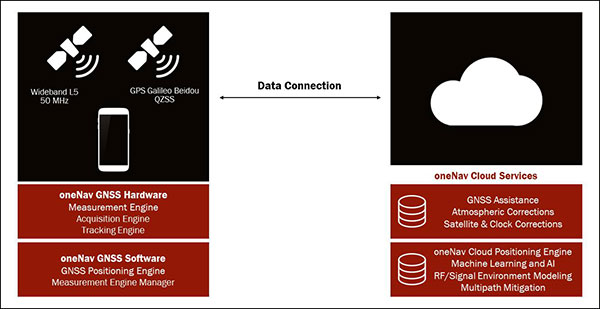
    The oneNav L5 mobile GNSS system architecture. (Image: oneNav)
    The oneNav L5 mobile GNSS system architecture. (Image: oneNav)

    L5 Wideband Receiver

    We set out to build a fifth-generation GNSS receiver for mobile consumer products. Its single-frequency design only uses the modernized, wideband signals at L5. It has an acquisition engine sophisticated enough to acquire L5 signals directly and a navigation engine that uses artificial intelligence/machine learning (AI/ML) techniques to fully exploit all the signals in 50-MHz wideband at L5.

    Optimized engine. Building an acquisition engine for the L5 signal is a huge mathematical task. Since the codes are 10 times longer and have a 10 times faster chipping rate, it’s a 100 times more difficult search problem. The oneNav engine solves that problem with a customized array processor that has a GPU-like approach, maintaining TTFF.

    Single-frequency architecture. Pure L5 architecture eliminates the need for a second RF chain. The oneNav L5 engine uses common hardware for signals from all GNSS systems.

    Increased sensitivity. The L5 signal has a modernized signal structure that allows for increased sensitivity for both acquisition and tracking. With wideband architecture, all parts of the L5 signal can be combined for maximum performance and significantly more signal strength than L1.

    Improved time to fix. Dual-band receivers first get a fix on L1 and then begin the acquisition process on L5. By performing the L5 acquisition directly, we save time.

    Acquisition reliability. The L1 signal structures do not have the longer primary codes and the secondary codes like modernized signals on L5 that mitigate many of the reliability problems associated with cross correlation, jamming and spoofing.

    Improved tracking and measurement. Using the full bandwidth allows a more sophisticated channel estimation than a simple pseudorange measurement. With multiple signals contained within the L5 wideband signal, we gain advantages from channel diversity.

    AI/ML navigation engine. A cloud-connected navigation engine uses advanced AI/ML techniques to further improve navigation accuracy. Sophisticated ML techniques to predict if the received signal is line of sight and predict the measurement error caused by multipath. The cloud service allows reflected signals to be used correctly in the navigation solution rather than being excluded due to their multipath content. A sophisticated pattern-matching-based positioning algorithm combines the pseudorange measurements and the environment’s 3D building map model to enhance positioning accuracy in deep urban canyons.

    IP Core

    We designed the oneNav receiver as a licensable IP core rather than a discrete silicon solution. The complete solution includes all the firmware and an RF front-end reference design from antenna to A/D converter. This allows customers to determine how to best bring the oneNav advantages to their products.

    The IP core can be integrated into a larger ASIC such as a modem or an SOC. It could also be implemented as a discrete silicon solution. The RF could be combined into any of these solutions or implemented with other RF components in the system. The measurement and position engine firmware can be run on a dedicated CPU or shared in either the same or different CPUs for flexible system integration optimal for various applications. The IP core is both process independent and scalable. An integrated GNSS core means that GNSS performance can be maintained across multiple platforms and silicon generations, providing consistency of measurement and positioning performance needed to maintain system reliability and fusion.

    In my opinion, the Pure L5 wideband receiver can be considered a next generation — or fifth generation — of GNSS for mobile consumer products.


    Greg Turetzky is vice president, Product, for oneNav, and a member of GPS World’s Editorial Advisory Board. Read the full white paper from oneNav.

  • Via acquires Fleetonomy for logistics and delivery technology

    Via acquires Fleetonomy for logistics and delivery technology

    Photo: Scharfsinn86/iStock / Getty Images Plus/Getty Images
    Photo: Scharfsinn86/iStock / Getty Images Plus/Getty Images

    Via, a provider of digital infrastructure for public mobility systems, has acquired Fleetonomy, a developer of fleet management software.

    Fleetonomy was founded in 2017 by CEO Israel Duanis and CTO Lior Gerenstein, with the vision of building the next generation of fleet management and optimization platforms, suitable for the challenges and opportunities that came with the shift to fleet-based on-demand services.

    According to Via, the purchase accelerates its expansion beyond public transit and strengthens its ability to meet increasing global demand for efficient, flexible solutions for logistics and delivery.

    Via’s technology is currently used in more than 150 cities and transit operators across the globe to power intelligent transit and delivery platforms, Via said. The need for essential transit and goods delivery has continued to grow during the COVID-19 pandemic, and Via plans to apply Fleetonomy’s technology and expertise in demand prediction and fleet utilization to advance its digitally-powered logistics solutions.

    “As we continue to build the next generation of public transportation and delivery infrastructure, we are proud to partner with Fleetonomy to step into this new phase of growth,” said Via Co-Founders Daniel Ramot and Oren Shoval. “We have been consistently impressed by Israel, Lior and the entire Fleetonomy team, and by the beautifully-designed and exceptionally-engineered products they have created. We share a vision for the future of mobility and look forward to realizing this vision together.”

  • New US Army PNT office welcomes industry on GPS-denied solutions

    New US Army PNT office welcomes industry on GPS-denied solutions

    The U.S. Army is opening a new office and laboratory to develop agile position, navigation and timing solutions to reduce soldiers’ dependence on GPS, according to reports in C4ISRNET and Defense News.

    The new PNT modernization product office will focus on developing and deploying solutions that keep soldiers operating in areas where the GPS signal has been denied, degraded or spoofed. The office will open Oct. 8, and will use an open-systems architecture.

    The new office will also host an Open Innovation Lab, a space where commercial entities can work with the Army to develop PNT solutions. Within lab, the Army has set aside space for the CMOSS (C4ISR/EW Modular Open Suite of Standards) Lab and the Network Cross-Functional Team’s Orion Forge at Aberdeen Proving Ground in Maryland.

    The lab will be physically separated from the more classified areas of the site to encourage engagement with industry. Technologies to be explored include radio frequency systems, GPS, alt-nav, chip-scale atomic clocks, other timing technologies and celestial navigation.

    According to the reports, the technologies will be fielded fast, with new solutions every five years. This is in contrast to the usual method of a decade spent developing technologies meant to last 20 years so that soldiers can always combat adversaries’ capabilities.

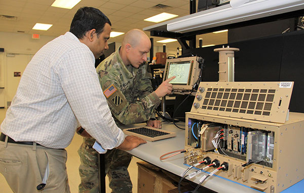
    Andradige Silva, electronics engineer for the C5ISR Center's Intelligence and Information Warfare Directorate, and Maj. Doug Williams, assistant product manager for the Joint Battle Command-Platform, access the C4ISR/Electronic Warfare Modular Open Suite of Standards (CMOSS). (Photo: U.S. Army)
    Andradige Silva, electronics engineer for the C5ISR Center’s Intelligence and Information Warfare Directorate, and Maj. Doug Williams, assistant product manager for the Joint Battle Command-Platform, access the C4ISR/Electronic Warfare Modular Open Suite of Standards (CMOSS). (Photo: U.S. Army)
  • Contact tracing applications market set to grow 15% CAGR through 2030

    Contact tracing applications market set to grow 15% CAGR through 2030

    Photo: da-kuk / iStock / Getty Images Plus/Getty Images
    Photo: da-kuk / iStock / Getty Images Plus/Getty Images

    According to a study by Future Market Insights, the contact tracing applications market is set to grow 15% CAGR through 2030.

    “Functional advantages of contact tracing applications include superior data quality, easier tracking and monitoring of larger numbers of people in a time effective manner, the ability of real time analysis, and the significant improvements to management and coordination of manual contact tracing teams,” said a lead analyst at Future Market Insights.

    Key highlights noted in the report include that the market for contact tracking applications is projected to display exponential growth through the forecast period on the back of the ongoing coronavirus crisis; decentralized, Bluetooth-based applications are likely to gain strong traction as a result of data privacy concerns; Android platforms are likely to contribute significantly to adoption owing through higher penetration of associated smartphone models; and Europe is expected to be a prominent market, with East Asia showing lucrative growth prospects on the back of mandatory use in China.

    COVID-19’s impact on the contact tracing applications market

    The COVID-19 pandemic has played a role in the contact tracking application market’s growth: according to the study, the pandemic has been the primary driver for the development, deployment and adoption of contact tracing applications. Government initiatives toward social distancing and patient tracking has influenced the industry’s growth, as well.

    The study also has projected an increase in disease control applications as a result of the COVID-19 pandemic.

    According to the study, countries such as Ireland and South Korea have been able to use contact tracing applications to gain promising results towards breaking chains of coronavirus patients, limiting the risks of community transmission.

    Despite the market’s growth, demand for these applications has been limited to countries with high rates of smartphone penetration. In addition, ethical problems in terms of transparency, privacy and accountability have restrained adoption during this period.

    “However, prospects for contact tracing applications remain positive for the post-pandemic era, owing to potential for use in controlling other infectious disease outbreaks worldwide, albeit at a smaller scale,” the report said.

    This report analyzed various strategies employed by major companies operating in the contact tracing applications market. Some of the participants operating in the contact tracing applications market include IBM, Oracle, Microsoft, Apple, T-Systems, SAP SE, Salesforce.com, Siemens AG and ServiceNow.

  • Bynav introduces C1 GNSS receiver for GNSS mass market

    Bynav introduces C1 GNSS receiver for GNSS mass market

    Photo: Bynav
    Photo: Bynav

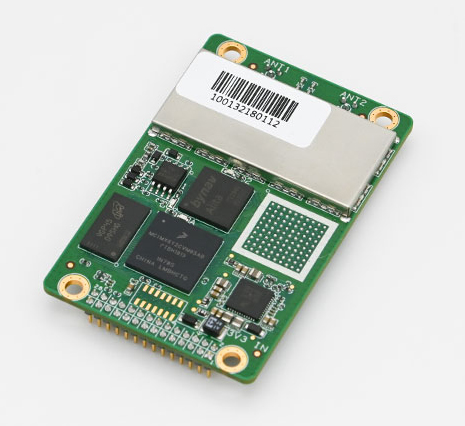
    Bynav Technology Co. Ltd. has released the C1 GNSS RTK OEM receiver and the A1 industrial-grade IMU-enhanced GNSS OEM receiver based on Bynav GNSS baseband ASIC Alita and RFIC Ripley. Bynav supplies GNSS high-precision receivers to the Chinese vehicle driver-testing market.

    The C1 GNSS RTK OEM receiver board measures 46 × 71 mm and supports dual-antenna heading and full-constellation, including GPS, BDS, Galileo, GLONASS, QZSS, NavIC and SBAS, as well as providing enhanced interfaces like UART serial port, Ethernet, 3 EVENT_IN, 3 EVENT_OUT, 1PPS and CAN bus for easy integration with an external inertial measurement unit (IMU), odometry, lidar or visual SLAM.

    The A1 GNSS/INS OEM receiver, measuring 46 × 71 mm and weighing 25 g, is integrated with an industrial-grade IMU (gyro 2.7deg/hr) with an embedded, deeply coupled GNSS+INS algorithm engine as well as tilt measurement algorithm to provide stable, high-precision position and attitude even in the event of GNSS outages.

    Most of the vehicle driver testing centers in China have automated their exams with the assistance of GNSS high-precision positioning. As a strategic partner of Duolun Technology, China’s driver-testing system integrator, thousands of drivers testing vehicles equipped with Bynav GNSS RTK receivers are moving around China every day.

    The R&D team of Bynav has taken part in the construction of China BeiDou Satellite Navigation System since 2002. With a powerful and experienced GNSS experts’ team and large-scale scenario verification on dynamic driver-testing vehicles, Bynav has successfully developed the high-precision GNSS baseband ASIC Alita and the RFIC Ripley which have been now integrated in the A1 and C1 products.

    The performance of the A1 and C1 have been verified and recognized by many domestic customers in the field of vehicle driver testing and autonomous driving.

    “We are committed to developing intelligent driving vehicles and commercializing them as soon as possible, in which the GNSS/INS receiver plays an important role to provide absolute position,” said Ying Long, deputy general manager of the Changsha Intelligent Driving Institute, a well-known autonomous driving company in China. “That’s why I started work together with Bynav for a cost-effective and high-performance positioning solution. Currently, the Bynav’s GNSS/INS receivers have been used in our unmanned sweepers, self-driving trucks and other products, and it comes out that the A1 performance is comparable to the world-class and high-end products we used.”

    Both receivers support dual-antenna heading and full-constellation and full-frequency tracking (including BDS-3 and L5), and provide SD card interface for raw data storage.

    Both C1 and A1 are now available for direct purchase. For wholesale price, contact [email protected].

  • Russia tests new GLONASS-guided missile

    Russia tests new GLONASS-guided missile

    Photo: Russia Ministry of Defense
    Photo: Russia Ministry of Defense

    The Russian Defense Ministry has tested new ammunition for its Tornado-S missile system, which is delivered via the multiple launch rocket system (MLRS), reports Russian newspaper Izvestia. Tornado-S is an ultra-long-range missile with a previous flight.

    The new MLRS is equipped with GLONASS signal reception equipment and an automated guidance and fire control system. The operator can enter coordinates into the system and give the command to set the guides and open fire. In addition, the system can itself receive and process information from reconnaissance vehicles and drones. For each missile, both range and azimuth angle can be set. The MLRS can launch 12 missile at once.

    Previously, the declared flight range of the Tornado-S missiles was about 120 km. Distance with the new ammunition was not disclosed, but the goal was 200 km. The main feature of the missiles is the ability to turn on the target after launch.

    The Russian Army was expected to receive 30+ Tornado MLRS this year.

  • Using GPS as a weapon against coronavirus

    Using GPS as a weapon against coronavirus

    By Roi Mit, CMO, Regulus Cyber

    Roi Mit, CMO, Regulus Cyber
    Roi Mit, CMO, Regulus Cyber

    GPS technology is doing far more than helping us navigate or receive accurate time. It is now being used to fight the spread of the global COVID-19 pandemic.

    Global navigation satellite systems are being used to collect big data on travel and contact, but they are also being used in more unconventional ways: for example, quarantine enforcement and sanitation technology.

    Read on to learn about a few recent developments in the world of GNSS/GPS that are bolstering the battle against the novel coronavirus.

    Electronic monitoring enforces quarantine

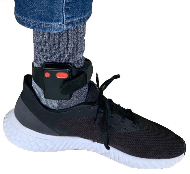
    There is a surge of applying ankle monitors to track sick individuals and deter them from spreading the virus further. According to Bloomberg Businessweek, one business is thriving because of it: providers of electronic ankle monitors.

    Kentucky courts are requiring GPS ankle monitors for people who test positive for COVID-19 and refuse to self-quarantine. Kentucky couple Elizabeth and Isaiah Linscott were two of a growing number of people placed under house arrest after Elizabeth tested positive for COVID-19 and denied signing the Self-isolation and Controlled Movement Agreed Order, a health department document promising she would stay home.

    Photo: Regulus Cyber
    Photo: Regulus Cyber

    Elizabeth told Louisville television station WAVE 3 News that she did not sign because she disagreed with the wording of the document. She said that she was concerned about having to contact the health department before traveling, even in the case of an emergency.

    “My part was if I have to go to the ER, if I have to go to the hospital, I’m not going to wait to get the approval to go,” she said.

    A few days after Elizabeth refused to sign the paperwork, her husband opened their door to an entourage of law enforcement officers serving them with a Health Department order to wear ankle monitors.

    “I open up the door, and there’s like eight different people, five different cars, and I’m like ‘what the heck’s going on?’ This guy’s in a suit with a mask. It’s the Health Department guy, and they have three papers for us. For me, her and my daughter,” Isaiah said.

    The Linville family is now confined to a 200-foot radius. If they leave their designated quarantine area, their ankle monitors will alert law enforcement.

    Alternative to prison

    The number of people on house arrest in the United States and across the world has surged as corrections departments struggle to slow the spread of the coronavirus within prisons. An estimated 25 to 30 percent more people are wearing ankle monitors in comparison with a few months ago, according to Bloomberg Businessweek. The U.S. Federal Bureau of Prisons reported a 160 percent increase in home confinement from late March to July. European corrections departments have similarly put thousands of inmates on house arrest in the last few months.

    “Demand has spiked everywhere,” BI Inc. monitoring equipment executive Robert Murnock said to Bloomberg. “We’re getting calls from different jurisdictions and other countries we’ve never worked with.”

    Efforts to reduce crowding in prisons mean that the electronic monitoring industry is one of very few industries benefiting financially from the coronavirus pandemic.

    “Coronavirus gives electronic monitoring companies an opportunity like they’ve never had before to expand,” parole reform expert James Kilgore said.

    On Aug. 3, Singapore announced the rollout of electronic tracking devices to enforce quarantine. Travelers will be required to wear GPS and Bluetooth-powered tracking devices that notify authorities if quarantine is broken or the device is tampered with. The rule went into effect on Aug. 11 and applies to all incoming travelers — resident or nonresident — over the age of 12.

    On Aug. 20, the premier of Western Australia, Mark McGowan , said his government could soon force people in hotel quarantine to wear electronic monitoring equipment if they are deemed a risk. “If we identify people who are potential flight risks or who might have a criminal history, we are looking at applying monitoring bracelets to them,” he said.

    An estimated 25 percent to 30 percent more prisoners are wearing bracelets now compared to the pre-outbreak period. In the U.S., the Federal Bureau of Prisons has placed about 4,600 inmates in home confinement, a 160 percent increase since the end of March.

    “Demand has spiked everywhere,” said Robert Murnock, vice president for partnership development at BI Inc., a provider of EM technology.

    The emergency shift to electronic monitoring spurred by COVID-19 may foretell a long-term shift toward use as an alternative to prison time, reducing clutter and the risk of the virus spreading among inmates.

    Photo: LeoPatrizi/E+/Getty Images
    Photo: LeoPatrizi/E+/Getty Images

    Contact tracing via mobile phones

    Israel is using covert mobile phone data to track the spread of COVID-19. On July 1, the Knesset approved a bill temporarily reauthorizing mass surveillance of coronavirus-infected citizens by the Shin Bet, Israel’s internal security service. The original program lasted from mid-March to June 9.

    The contact-tracing program works like this. When a patient is diagnosed with COVID-19, the Israeli Health Ministry provides their personal information — including their mobile number — to the Shin Bet. The Shin Bet then consults a classified database of every person who uses Israeli telecom services to determine who came into contact with the infected individual for more than 15 minutes at a time. After the Shin Bet sends information back to the Health Ministry, the Health Ministry notifies those people via text and tells them to self-quarantine.

    The Shin Bet’s newfound role in public health enforcement is quite different from its usual focus. Former Shin Bet agents say the COVID-19 mobile phone tracking technology was originally developed as a counterterrorism measure, and the tracking system being used on Israeli civilians is almost identical to that used for suspected terrorists.

    “It’s the same system, the same methods,” retired Shin Bet agent Arik Brabbing said to BBC. “We know that someone was here in the park. We can get from the [mobile phone] company all the details about the hour, the place, exactly the place… and we can understand who else was around.”

    Supporters of the mass surveillance program, including Prime Minister Benjamin Netanyahu, argue that reduced privacy is necessary to curb the spread of the virus. However, the Israeli government has come under fire by opponents who claim that the program is intrusive and undemocratic.

    Israel’s contact tracing procedures are more secretive than those of South Korea and Taiwan, other countries that mandate central mass surveillance. South Korea and Taiwan both enforce quarantines with mobile-phone tracking, and both have built publicly available COVID-19 data platforms.

    The South Korean government has disseminated detailed — but anonymized — information about COVID-19 carriers, including their travel routes and treatment facilities. Citizens broadly support these measures — a testament to collectivism in Korean culture.

    Civic engagement and enthusiasm for fighting the pandemic is also remarkable in Taiwan, where the public has been collaborating with the government on a town hall-style website called vTaiwan. Citizen-led initiatives, like a GPS-powered tool for tracking face mask supplies, have been applied nationwide.

    Meanwhile in Europe, eight major telecom companies, including Vodafone and Orange, have been supplying anonymized metadata to the European Commission to model and predict the spread of the virus. In the United States, the Centers for Disease Control and Prevention is soliciting GPS data from mobile advertising companies rather than carriers themselves.

    The two tech giants, Apple and Google, made it easier for health agencies to join its coronavirus exposure notification system, creating a new built-in app within iOS and Android. The app provides real-time notification to users when they are exposed to a sick person.

    Virus-killing robots may roam the streets

    GPS-based robots, drones and autonomous cars are being deployed to sanitize outdoor spaces, transport medical equipment, and announce safety information to the public.

    Robots began rolling around the streets of Wuhan, the original epicenter of the coronavirus outbreak, as early as January. China was the first to deploy robots of this type, but India, Spain, France and other countries have followed in their footsteps. In addition to the chemical-spray approach, some companies are pioneering mobile disinfection robots armed with large ultraviolet-C germicidal lights.

    Apollo, the autonomous vehicle company of multinational internet giant Baidu, has partnered with Chinese self-driving startup Neolix to transport food and supplies to Beijing Haidian Hospital. Every morning at 10:30 a.m, an unmanned car delivers meals to about 100 frontline workers. The process eliminates direct contact, protecting the safety of food service workers, hospital staff, and patients.

    Zhangjiang Artificial Intelligence Island

    A fleet of Apollo and Neolix’s unmanned cars is also responsible for disinfecting all roads on Zhangjiang Artificial Intelligence Island, an 100,000-square-meter industrial complex in Shanghai. The vehicles are loaded with up to 160 liters of spray disinfectant and can cover the island’s entire road system in about half an hour.

    The vehicles at Zhangjiang AI double as nighttime surveillance bots. They patrol the island and make sure that guests are adhering to coronavirus protocols, alerting security personnel if they note suspicious activity.

    In addition to using drones to spray disinfectant, South Korea’s government has leveraged the technology for public announcements. On July 4, 300 drones lit the sky above Seoul in a show of appreciation for frontline workers. The drones executed a 10-minute synchronized show that included images of face masks, hand washing, and social distancing.

    Summary

    As COVID-19 continues to ravage the globe, governments rely on GPS to track the virus, contain it, and fight against it. The battle against coronavirus is still being waged on a global scale, utilizing GPS as a weapon along with many other existing technologies.

    The pandemic changed the world forever, and it also highlighted the power of tracking and monitoring location of people and machines. It is another testament to the immense reliance on GPS technology in our modern world.

    The increased deployment of these technologies necessitates increased security measures, especially when public health is on the line. Regulus Cyber offers GPS Cybersecurity software. To read more about it, visit www.regulus.com.

    Sources

    Altshuler, Tehilla Shwartz, and Rachel Aridor Hershkowitz. “How Israel’s COVID-19 Mass Surveillance Operation Works.” Brookings, Brookings, 6 July 2020.

    Aravindan, A., & Geddie, J. (2020, August 03). Singapore to make travellers wear electronic tags to enforce quarantine (E. Davies, Ed.). Retrieved August 10, 2020.

    Bateman, Tom. “Coronavirus: Israel Turns Surveillance Tools on Itself.” BBC News, BBC, 12 May 2020.

    Chee, Foo Yun. “Vodafone, Deutsche Telekom, 6 Other Telcos to Help EU Track Virus.” Reuters, Thomson Reuters, 25 Mar. 2020.

    Couple under House Arrest Says They’re Getting Hateful Comments.” ABC13 Houston, 22 July 2020.

    Eligon, John. “’It’s a Slap in the Face’: Victims Are Angered as Jails Free Inmates.” The New York Times, 24 April 2020.

    Gelb, Michael, et al. “COVID-19 Boosts Fortunes of Electronic Monitoring Firms.” The Crime Report, 16 July 2020.

    Kim, Max S. “Seoul’s Radical Experiment in Digital Contact Tracing.” The New Yorker, 17 Apr. 2020.

    King, Faith. “Ky. Couple on House Arrest after Not Signing Positive COVID-19 Self-Isolation Order.” wave3.com, 19 July 2020.

    Kluth, Andreas. “Taiwan Offers the Best Model for Coronavirus Data Tracking.” Bloomberg, 22 April 2020.

    Mobile Location Data and Covid-19: Q&A.” Human Rights Watch, 3 Aug. 2020.

    School Uses Virus-Killing Robot to Keep Classrooms Clean amid COVID-19 Pandemic.” ABC7 San Francisco, 2 Aug. 2020.

    Tabachnick, Cara. “Coronavirus Creates Big Market for Electronic Ankle Monitors.” Bloomberg, 14 July 2020.

    Tau, Byron. “Government Tracking How People Move Around in Coronavirus Pandemic.” The Wall Street Journal, Dow Jones & Company, 28 March 2020.

    COVID-19 pandemic prompts more robot usage worldwide

    https://www.cnn.com/2020/07/08/asia/south-korea-drones-trnd/index.html

    https://www.technologyreview.com/2020/05/18/1001760/how-coronavirus-is-accelerating-autonomous-vehicles/

    https://www.travelpulse.com/news/destinations/singapore-to-require-electronic-monitoring-device-for-incoming-travelers.html

    https://www.straitstimes.com/asia/se-asia/quarantine-monitoring-devices-also-being-used-by-others-worldwide

    https://lostcoastoutpost.com/2020/aug/31/looking-relieve-jail-overcrowding-sheriffs-office/

    https://thecrimereport.org/2020/07/15/covid-19-boosts-fortunes-of-electronic-monitoring-firms/

  • New Esri app shows air quality with demographics

    New Esri app shows air quality with demographics

    Image: Esri
    Image: Esri

    Esri has released a new mapping app, Air Quality Aware, that fuses data from the EPA’s AirNow program, NOAA’s National Weather Service wind forecast and the American Community Survey to provide location intelligence on current air quality and its impacts on local communities.

    At a national level, areas are color-coded according to EPA’s Air Quality Index, with magenta and purple representing hazardous and very unhealthy air quality.

    As users zoom in, the map shows the air-quality scores reported at each individual air-quality monitoring station.

    Users can click on any station for more information about the pollutants and concentrations reported at that location. They can also search for or click any place on the map to get more information about current and forecasts of air quality, wind speed and insights about the vulnerable population in each place.

  • Eos Locate for ArcGIS now compatible with Subsite Electronics products

    Eos Locate for ArcGIS now compatible with Subsite Electronics products

    Photo: Eos Positioning Systems
    Photo: Eos Positioning Systems

    Eos Locate for Collector for ArcGIS underground mapping is now compatible with three Subsite Electronics products.

    Introduced in 2019 by Eos Positioning Systems, Eos Locate is a real-time, survey-grade solution for mapping underground utilities with ArcGIS field apps. With Eos Locate, one field worker can collect both GNSS locations and locator data (such as depth below cover) for any buried asset including water, sewer, electric, cable, gas, fiber infrastructure and more. They can do so quickly, accurately and without the need for any additional field or office support.

    The solution requires an Arrow GNSS receiver, Esri licensing, an iOS device, and a compatible locator.

    This expansion adds compatibility for two new utility locator models and one HDD guidance system: the UtiliGuard (with Bluetooth option enabled), UtiliGuard 2, and TK Recon. Eos Locate for Collector combines three core technologies: Eos Arrow GNSS receivers, Esri Collector and the Vivax-Metrotech vLoc Series of locator devices.

    “We are extremely excited to expand this popular underground mapping solution to Subsite Electronics customers,” said Eos Chief Technology Officer Jean-Yves Lauture. “Utilities have been asking us to add compatibility, and we are pleased to announce that this integration is now available today, for no extra cost, to our existing customers.”

    “At Subsite, we are constantly listening to customer needs and providing solutions accordingly,” Subsite Electronics Senior Product Manager Christopher Thompson said. “We have a lot of customers who perform this type of work, and by partnering with Eos, we are able to provide a solution today to continue providing our customers with the tools and technology for total underground awareness.”

    Thanks to the TK Recon integration, it is now possible to map horizontal directional drilling operations in real-time with Eos Locate, for both performing as-built reports and monitoring.

    To use Eos Locate with Subsite devices, customers must download Eos Tools Pro (version 1.89 and higher) from the App Store for free. Eos Locate is compatible with both Esri ArcGIS Collector and ArcGIS Field Maps. Follow this manual or watch these video tutorials to get started.