Category: Applications

  • Launchpad: GNSS receivers, sensors, software

    Launchpad: GNSS receivers, sensors, software

    A roundup of recent products in the GNSS and inertial positioning industry from the September 2020 issue of GPS World magazine.


    OEM

    Inertial sensors

    Includes four models
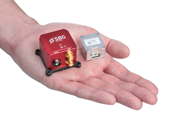
    Photo: SGB Systems
    Photo: SGB Systems

    The third-generation Ellipse series has a 64-bit architecture, allowing high-precision signal processing. All of the INS/GNSS devices now embed a dual-frequency, quad-constellation GNSS receiver for centimetric position and higher orientation accuracy. The Ellipse-A is a motion sensor; Ellipse-E provides navigation with an external GNSS receiver; Ellipse-N is a single-antenna RTK GNSS/INS; and Ellipse-D is a dual-antenna RTK GNSS/INS. With its new 64-bit architecture, the third-generation Ellipse series enables the use of high-precision algorithms and technology used in high-end inertial systems such as rejection filters and FIR filtering.

    SBG Systems, sbg-systems.com

    Assured Reference

    Protects critical infrastructure
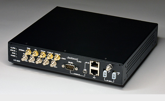
    Photo: Jackson Labs
    Photo: Jackson Labs

    The PNT-6220 Assured Reference combines low-Earth-orbit (LEO) signals, GNSS, terrestrial, wireline and atomic clock services in one small solution for critical infrastructure applications. The PNT-6220 seamlessly combines concurrent L1, L2, L3 and L5 GNSS reception with a LEO-based Satellite Time and Location (STL) timing receiver. It also includes terrestrial receivers and PTP/IEEE-1588 edge grandmaster and PTP/IEEE-1588-slave capability. It provides assured PNT for critical infrastructure applications such as those described in the directives of Presidential Executive Order 13905. It can serve as a timing reference for 5G equipment, an ePRTC-capable reference, or a high-performance disciplined reference that supports PTP/IEEE-1588, STL, RF distribution and multi-frequency GNSS capability. The PNT-6220 can automatically select the most optimal UTC reference input and switch over among its numerous reference inputs if one or more are jammed or spoofed, as well as average several references for additional stability and accuracy.

    Jackson Labs Technologies, jackson-labs.com

    GNSS Receiver

    Integrates correction service
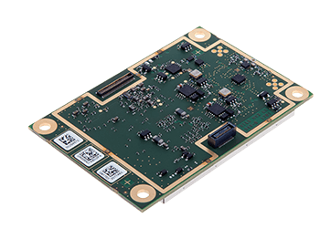
    Photo: Septentrio
    Photo: Septentrio

    The AsteRx-m2 Sx OEM board provides a GPS/GNSS receiver with always-on sub-decimeter accuracy without the need for additional correction service subscriptions. GNSS corrections are automatically streamed to the receiver. The integration enables plug-and-play positioning with high accuracy available out of the box. The AsteRx-m2 Sx is an efficient positioning solution for small robots, aerial drones and automation applications. Advanced anti-jamming technology AIM+ ensures robust and reliable operation in challenging environments, even in the presence of RF interference.

    Septentrio, septentrio.com

    Inertial navigation

    Board set for system integrators
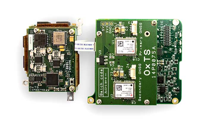
    Photo: OxTS
    Photo: OxTS

    The xOEM v3 inertial navigation system includes the architecture from the company’s IP65-encased xNAV v3 as well as a full range of software interfaces, providing integrators maximum configuration flexibility, real-time monitoring, post-processing and analysis. Software interfaces can be customized using the OxTS NAVsuite. Plugins can be created using the company’s NAVsdk, allowing the xOEM v3’s software to be easily packaged and included as part of a product.The high-grade MEMS inertial sensors and real-time kinematic (RTK)-capable GNSS receiver within the xOEM v3 board set deliver high performance capabilities. The board set provides 0.1° heading accuracy, 0.05° pitch/roll accuracy and 2 cm global position accuracy. The board set is compact at 150 grams, which enables manufacturers to seamlessly integrate and build a high-performance INS into their products, such as commercial mapping applications on land and in the air. Its light weight means more payload capacity for other critical components. An add-on lidar georeferencing software package is also available with a sophisticated boresight calibration tool.

    Oxford Technical Solutions, oxts.com


    SURVEYING & MAPPING

    GNSS receiver

    Designed to supplement M300 Pro
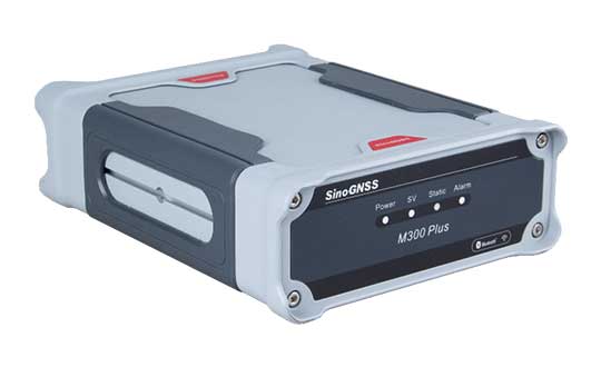
    Photo: ComNav
    Photo: ComNav

    The M300 Plus GNSS receiver is designed to supplement the company’s M300 Pro, which is aimed at clients who need a more economical version for their CORS networks. The M300 Plus is also designed for monitoring projects and other applications. By using a powerful, adaptive detecting and canceling technology, the M300 Plus provides enhanced anti-jamming capability, which is critical for a reference station providing reliable GNSS data. Its built-in web server provides remote control of receiver configuration, status, firmware update and data download. It uses a 4G module as an internet backup, enhancing the stability of data connections.

    ComNav Technology, comnavtech.com

    3D lidar

    For security and smart city markets
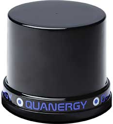
    Photo: Quanergy
    Photo: Quanergy

    The MQ-8 family — 3D lidar sensors and perception software — are part of Quanergy’s Flow Management platform. Designed with a new smart beam configuration, the MQ-8 solution delivers up to 140 meters of continuous tracking range, enabling up to 15,000 m2 of coverage with a single sensor. It is suitable for flow management applications such as security, smart city, social distancing and smart space industries.

    Quanergy Systems, quanergy.com

    3D building layer

    More than 350 million buildings

    Screenshot: Cesium
    Screenshot: Cesium

    Cesium OSM Buildings expands the company’s suite of Global Base Layers including worldwide terrain, aerial imagery and streetmaps already available. With the new layer, 3D buildings can be visualized, styled and analyzed in an efficient and interoperable manner using 3D Tiles, the open standard developed by Cesium to stream massive 3D geospatial datasets. The layer gives geospatial developers urban context to 3D applications. The buildings are created for efficient visualization and are streamable to any device with 3D Tiles.Cesium OSM Buildings are derived from OpenStreetMap. Buildings are also regularly updated, firmly clamped to terrain, and individually selectable and styleable.

    Cesium, cesium.com

    Mobile app upgrade

    Version 2.1 Supports Advanced GPS
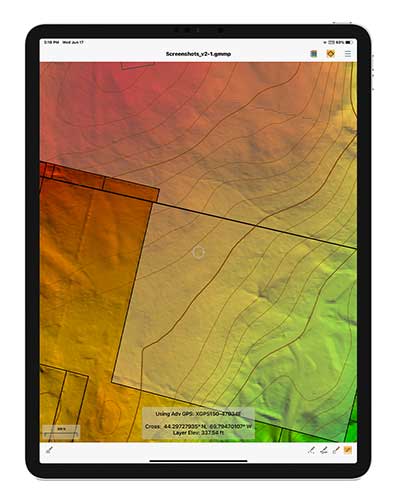
    Photo: Blue Marble
    Photo: Blue Marble

    Version 2.1 of Global Mapper Mobile provides updates to both the free and Pro versions. The iOS and Android applications are designed for viewing and collecting GIS data, and provide situational awareness and location intelligence for remote mapping projects. A complement to the desktop version, the mobile app can display all supported vector, raster and elevation data formats. The release improves vector feature styling, terrain layer support and layer transparency setting. In the Pro version, it introduces advanced GPS support, allowing users to connect to external, high-accuracy Bluetooth GPS devices from vendors such as Eos Positioning and Bad Elf. It also allows access to detailed information including the satellite constellation, precise location information and the raw NMEA stream.

    Blue Marble Geographics, bluemarblegeo.com


    UAV

    Energy industry ops

    For monitoring UAS operations

    Photo: aerogondo/iStock/Getty Images Plus.Getty Images
    Photo: aerogondo/iStock/Getty Images Plus.Getty Images

    The AiRXOS Enterprise Energy Solution provides digital compliance, situational awareness of airspace and assets, inspection, emergency response/disaster recovery capabilities, analytics and asset performance tools in a connected platform. It runs on AiRXOS’ Air Mobility Platform — a secure, cloud-based, extensible platform that enables integration of an energy organization’s current applications and other UAS service suppliers. It brings all UAS lifecycle operations into one view, including infrastructure inspection, asset and crew management, and emergency operations after a natural disaster.

    AiRXOS, airxos.io

    Fixed-wing UAV

    For surveying and monitoring
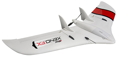
    Photo: Hitec
    Photo: Hitec

    The Xeno FX is a fixed-wing platform optimized for efficient and cost-effective area survey and monitoring missions. Users can program the flight plan before launch to ensure thorough coverage of a target region. The fixed-wing design allows for efficient cruise and maximum time aloft. The Safe Launch protective feature means the propeller starts spinning only after the airframe has been safely hand launched. A quick-change modular payload system allows users to reconfigure their data-acquisition hardware for multiple missions. Constructed of Multiplex’s resilient Elapor foam, the folding wings make for compact storage and easy transport.

    Hitec, hitecnology.com  

  • IoT kit ready for heavy workloads

    IoT kit ready for heavy workloads

    logoCongatec is offering a workload consolidation kit for vision-based situational awareness applications such as machine control and vision-based collaborative robotics.

    The kit qualifies as an Intel internet of things (IoT) ready-for-production kit. It offers three virtual machines based on the hypervisor technology from Real-Time Systems.

    One runs a vision-based artificial intelligence application based on the Intel OpenVino situational awareness software. The second is real-time capable and operates deterministic control software, and the third acts as an industrial IoT/Industry 4.0 gateway.

  • MGISS partners with ESA to sponsor Northumbrian Water Innovation Festival

    MGISS partners with ESA to sponsor Northumbrian Water Innovation Festival

    Image: MGISS
    Image: MGISS

    Mobile GIS Services (MGISS) is working with the European Space Agency (ESA) to showcase the potential of satellite positioning systems and imagery in tackling some of the environmental and societal challenges being faced by the water industry.

    The two organizations joined together to develop multimedia experiences, group exercises and real-world case studies, which will be shared at the Northumbrian Water Innovation Festival, taking place Sept. 15.

    The four-day festival, which has attracted more than 6,500 visitors across previous events, will take place virtually from Sept. 14-17.

    “Under the theme ‘We Need Space to Innovate,’ we are aiming to explore how we can use satellite services to improve asset management for organizations such as Northumbrian Water, alongside the wider water and critical infrastructure sectors,” said Mike Darracott, MGISS managing director.

    A highlight of the organizations’ participation will their Daily Dashes. The Daily Dashes will be rapid, sprint-style workshops that run through all stages of the subject and include music, video, live demonstration and hands-on workshops to explore specific topics relevant to the water industry. According to MGISS and ESA, the Daily Dashes will provide a better understanding of how satellite services can be used to improve asset insight and operational performance.

    “Satellite positioning systems are extensively used for asset location, and yet do users really understand the full array of technology on offer or the additional potential that can be derived from earth observation data?” Asked Alan Cross, regional ambassador for ESA. “By working with MGISS, we will demonstrate how improved positioning and asset insight has the potential to deliver benefits for operational resilience, improved safety and higher productivity.”


    GPS World’s November 2020 issue will focus on water applications, so stay tuned for that issue.

  • 
Tallysman offers AccuAuto embedded GNSS antennas for autonomous vehicles

    
Tallysman offers AccuAuto embedded GNSS antennas for autonomous vehicles

    Photo: Tallysman
    Photo: Tallysman

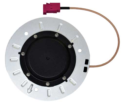
    Tallysman Wireless has added a line of AccuAuto vehicle antennas aimed at the autonomous vehicle market.

    The compact and rugged embedded AccuAuto antennas offer key features not available in other embedded autonomous vehicles antennas on the market, the company said.

    The automobile industry is transitioning from offering GNSS-assisted navigation where the accuracy requirement is ±3 to 5 meters (low-precision GNSS code positioning) to providing driver assistance (such as lane-keeping) and autonomous vehicle navigation where the accuracy requirement is < 0.1 meters (such as high-precision GNSS phase positioning).

    Current roof-mounted GNSS antennas on most vehicles provide the accuracy required for navigation but they lack the precision required for assisted driving or autonomous vehicle operation. Tallysman’s new line of AccuAuto antennas are designed to provide strong clean code and phase signals that enable high-precision real-time kinematic (RTK) and precise point positioning (PPP) navigation.

    The Tallysman embedded AccuAuto vehicle antenna features a patented Tallysman Accutenna technology multi-constellation and multi-frequency antenna element, an integrated ground plane, radome and underside cover that provides mist and condensation protection.

    The bottom cover also supports the antenna cable and mitigates cable vibration to ensure the antenna has a long service life, while the ground plane improves antenna performance.

    All AccuAuto antenna electronic components are Automotive Electronics Council (AEC) certified and are designed to perform under challenging environmental conditions, such as extreme temperatures (–40 °C to +125 °C) and continuous shock and vibration.

    Signal quality is improved with a deep pre-filter that minimizes out-of-band noise and maximizes in-band reception. This feature enables reliable GNSS signal reception in challenging urban environments, where inter-modulated signal interference from LTE and other cellular bands is common.

    The triple-band TWA928 supports GPS/QZSS-L1/L2/L5, GLONASS-G1/G2/G3, Galileo-E1/E5a/E5b, BeiDou-B1/B2/B2a, and NavIC-L5 signals and frequency bands (the TWA928L includes support for L-band correction services).

  • Hexagon survey-grade GNSS rover measures what you see

    Hexagon survey-grade GNSS rover measures what you see

    Photo: Hexagon
    Photo: Hexagon

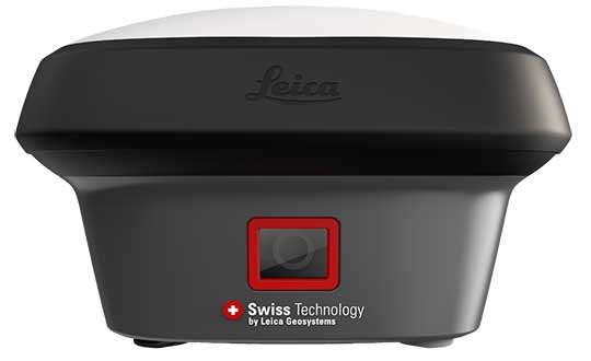
    Hexagon AB has introduced the Leica GS18 I, a versatile, survey-grade GNSS RTK rover so powerful it enables surveyors to measure what they see, even structure in difficult-to-reach places, the company said.

    It comes equipped with all the innovative functionality of the Leica GS18 T — Hexagon’s calibration-free, tilt-compensating GNSS solution immune to magnetic disturbances, plus the power of survey-grade visual positioning.

    Through sensor fusion of GNSS, motion (IMU) and image (camera) technology, the Leica GS18 I enables the measurement of points from images. The ability to capture and measure sites via images goes far beyond the advantages of the GS18 T, which introduced the quick and convenient ability to measure points in spaces that cannot be measured with vertical poles, such as building corners, walls and points underneath obstacles (for instance, cars).

    With the Leica GS18 I, professionals can now map areas that are difficult to reach physically, such as trenches, high power lines and busy roads, or blocked from GNSS signals, such as areas underneath bridges or canopies — safely and effortlessly from a distance.

    “With the Leica GS18 I, mapping and surveying just got simpler, safer and more productive than ever before,” said Ola Rollén, Hexagon president and CEO. “The ability to quickly document an entire area of interest without the need to switch between tools or manoeuvre through obstacles frees up equipment and crews. Additionally, the simple and intuitive workflow of the Leica GS18 I brings the versatility of visual positioning to new user segments and applications — from utility service providers to crash scene investigators.”

    The Leica GS18 I enables users to measure hundreds of points within minutes. Integration with Leica Captivate field software enables intuitive onsite point measurements and quality assurance from the field.

    Further measurement of the captured images is supported by integration with Leica Infinity office software, which also enables the creation of automatically registered and referenced 3D point clouds from the images in standard export formats for use in a variety of point cloud software.


    Feature image: Hexagon

  • New NGS study examines GIS surveys for airports

    New NGS study examines GIS surveys for airports

    <a href="http://stage.globalpositioningnews.com/wp-content/uploads/2020/08/ASP-Revised-Final-Socio-Economic-Report-July-29-2020.pdf" target="_blank" rel="noopener noreferrer">Download the report.</a>

    A new study for the National Geodetic Survey (NGS) reviews and validates airport surveys from a safety perspective.

    The study, “Protecting Against Airport Obstructions: Socio-Economic Study of the NGS Aeronautical Survey Program,” is by Irv Leveson and the staff of ARCBridge Consulting and Training Inc.

    Goals of the scoping study are to:

    • provide a better understanding of the activity, uses, users and broader beneficiaries of the National Geodetic Survey’s Aeronautical Survey Program,
    • help define its socio-economic benefits,
    • provide preliminary order of magnitude estimates of benefits of the program, and
    • examine influences on future needs for the program’s services.

    The footprint (trade space) analysis presents data on airport improvement grants, activities of the program, airports, aviation and societal beneficiaries. Methods of estimating socio-economic benefits are considered, preliminary estimates of benefits are made and issues that will affect use of the services in the future are discussed. Additional information is included in 10 appendices.

    The FAA Airport Improvement Program (AIP) provides grants, to public agencies for planning and development of the 3,249 eligible public-use airports and the 72 privately owned civil airports.

    The FAA requires that geographic information system (GIS) contractors submit plans and surveys with geodetic control, runway, navigational aid, obstruction and other aeronautical data under its Airports GIS (AGIS) program. These contracted survey plans and surveys are sent to the NGS Aeronautical Survey Program (ASP) for quality assurance review.

    The GIS information is used by the FAA in establishing flight rules and other requirements to assure safety.

    Download the report here.


    Irv Leveson is an economist with extensive experience examining GNSS markets, applications, benefits and policies. His public studies include: “The Economic Benefits of GPS.” He recently led a National Geodetic Survey study.

  • Verizon to deploy RTK stations for ‘hyper-precise’ location info

    Verizon to deploy RTK stations for ‘hyper-precise’ location info

    Verizon logoUsing RTK’s pinpoint-level location data in the Verizon network is a building block to bring to scale emerging technologies such as driverless city zones, expansion of precision agriculture and drone delivery.

    Verizon has launched what it calls hyper-precise location using real-time kinematics (RTK) to provide accuracy within one to two centimeters on the Verizon network.

    Verizon has built and deployed RTK reference stations nationwide so that compatible internet of things (IoT) devices can receive the higher accuracy. Verizon is working to make RTK accessible with myriad device makers.

    RTK will also support emerging technologies that depend on high-level location accuracy, such as delivery drones and customer-approved location data for first responders in emergencies.

    RTK technology reduces the cost and risk associated with inaccurate location data, Verizon said in a press release. “Billions of IoT devices across a multitude of industries will benefit from improved location accuracy, with hyper-precise location information enabling a host of new services.

    “For instance, robotics at distribution centers will be able to perform more efficient, accurate and safe logistics operations. More accurate positioning can help speed deployment of high-value assets in emergency situations to the precise location, and more precise tracking of emergency equipment can provide faster redeployment in disaster response scenarios.”

    The rollout of its hyper-precise location services along with Verizon’s 5G Ultra Wideband network and 5G Edge will pave the way for more autonomous technologies, the company said.

    “We are scaling RTK to enable mobile location accuracy to within a few centimeters, transforming what is currently possible when it comes to location-enabled services and new IoT solutions coming onto the market,” said Nicola Palmer, chief product development officer for Verizon. “Continued growth in the IoT environment means billions of devices in fields where precision location services are becoming more critical, such as vehicle automation, unmanned aerial vehicles, precision agriculture technology, infrastructure monitoring, asset tracking and high-value shipping.”

    Image: 4X-image iStock / Getty Images Plus / Getty Images
    Image: 4X-image iStock / Getty Images Plus / Getty Images

    Reimagining road safety

    In partnership with HERE Technologies, Verizon is building next-generation technologies for vehicle and pedestrian safety using hyper-precise high-definition mapping and RTK.

    This work paves the way for connected services that are designed to drive road safety improvements. By creating a vehicle-to-network (V2N) communication system equipped with hyper-local location accuracy, collision avoidance applications can precisely identify vehicles, pedestrians and bicycles, and relay the information through Verizon’s 5G Edge and HERE’s AI to predict likely travel paths and warn vehicles of impending potential collisions. This partnership is one of multiple recent initiatives Verizon has taken to increase road safety.

    “Moving beyond the static fidelity of satellite-based location data enables an exciting new generation of connected, autonomous experiences,” said Jørgen Behrens, SVP, chief product officer at HERE Technologies. “By pairing HERE’s live, hyper-precise HD Map and HD Positioning technologies with intelligent RTK algorithms, and making that scalable, Verizon is putting a transformative level of location insights into the hands of developers and consumers alike.”

    Powering the autonomous future

    Hyper-precise location accuracy will be critical to advancing autonomous driving and together, Verizon and Renovo are ushering in a new era of transformative solutions critical for the future of autonomy on the road. These solutions leverage machine learning and RTK technology, powered by a combination of next-generation solutions such as 5G.

    “RTK is a critical technology for advanced driving assistance systems (ADAS). Accurate positioning helps ADAS vehicles navigate better, drive smoother, and react faster to the surrounding environment,” said Christopher Heiser, CEO and Co-Founder of Renovo. “Nationwide, reliable RTK networks make for a viable way to deliver these enhanced capabilities to mass-market cars and trucks. For companies that manage the huge datasets that power next-generation vehicle platforms like Renovo, this is very exciting.”

    IoT devices currently using RTK can be accessed and managed through Verizon’s ThingSpace management platform and APIs.

  • Power of THOR ready to down enemy drones

    Power of THOR ready to down enemy drones

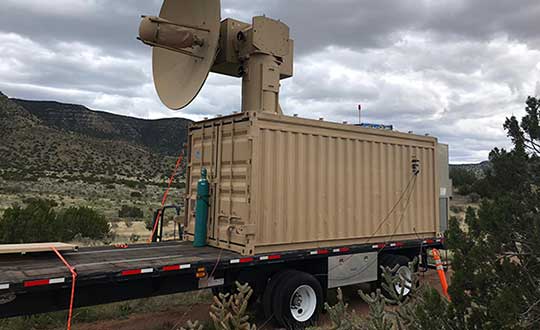
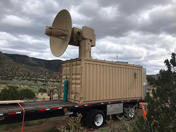
    The Air Force Research Laboratory (AFRL) has developed a counter-swarm high-power weapon to deter enemy drones — THOR.

    THOR stands for Tactical High-power Operational Responder, a counter-swarm electromagnetic weapon for airbase defense. Although AFRL’s THOR is not a hammer-wielding god associated with thunder and lightning, the system provides non-kinetic defeat of multiple targets. It operates from ground power and uses energy to disable drones.

    The THOR drone deterrent designed by the Air Force Research Laboratory. (Photo: AFRL)
    The THOR drone deterrent designed by the Air Force Research Laboratory. (Photo: AFRL)

    “THOR is essentially a high-powered electromagnetic source that we put together to specifically defeat drones,” said Stephen Langdon, chief of the High-Powered Microwave Technologies Branch of AFRL’s Directed Energy Directorate.

    AFRL is located at  Kirtland Air Force Base, New Mexico. A demonstration system has been built and tested on military test ranges near the base, where it has successfully engaged multiple targets. Further testing against a larger set of drone types in swarming configurations is being planned.

    THOR stores in a 20-foot transport container, which can be transported in a C-130 aircraft. The system can be set up within three hours and has a user interface that requires little training.

    The technology, which cost roughly $15 million to develop, uses high-power electromagnetics to counter electronic effect. When a target is identified, the silent weapon discharges with nearly instantaneous impact.

    With much of the necessary basic research previously completed at AFRL, THOR was rapidly developed and tested in 18 months.

    Although there are other drone defensive systems available, including guns, nets and laser systems, THOR will most likely to extend the engagement range to effect and decrease the engagement time over the other deterrent devices.

    Langdon said the THOR team hopes to transfer the technology to a System Program Office soon in order to get it into the hands of U.S. warfighters as soon as possible.

    AFRL exhibited THOR at the 2019 Air Force Association Air, Space and Cyber Conference at the Gaylord National Resort and Convention Center, located just across the Potomac River from Washington, D.C. and Virginia, Sept. 16-18.

  • Carlson introduces BRx7 redesigned GNSS receiver

    Carlson introduces BRx7 redesigned GNSS receiver

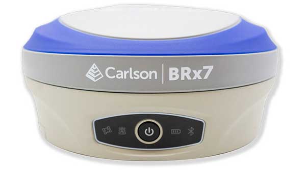
    Photo: Carlson Software
    Photo: Carlson Software

    Carlson Software is now offering its next-generation multi-frequency, multi-GNSS BRx7 smart antenna.

    The BRx7 is a full redesign of Carlson’s flagship GNSS receiver, delivering high-level specifications, performance and value for surveyors, contractors, engineers and GIS professionals.

    Weighing 2.8 pounds with batteries, the BRx7 saves time and increases productivity by accurately compensating for tilt. It comes standard with dual, hot-swappable batteries for 11+ hours of uninterrupted efficiency. The BRx7 provides 800+ channels, 8gb of memory, and is designed with a rugged, compact IP67-rated housing.

    Best-in-class RTK performance is provided by the Athena GNSS engine, supporting multi-frequency GPS, GLONASS, BeiDou, Galileo, QZSS, IRNSS and Atlas L-band capability. In addition, the BRx7 uses proprietary SureFix technology to provide a high-fidelity quality indicator of the RTK solution, allowing users an extremely high confidence in their current accuracy.

    The BRx7 provides RTK baselines up to 50 km with fast acquisition times when used with Carlson Listen-Listen, as well as UHF, spread spectrum, cellular, Bluetooth and Wi-Fi wireless communication.

    Well-suited to a variety of operating modes, the BRx7 can be deployed as a powerful base with additional access to BeiDou phase 3 satellites in a base-rover setup, or as a lightweight, powerful network rover.

    “The BRx7 represents the next generation of GNSS technology,” said Butch Herter, Carlson’s director of hardware development. “Through this total redesign in partnership with our manufacturer, Hemisphere GNSS, we’ve brought the technology and functionality above the competition while retaining the ease-of-use, durability, and superior support that Carlson is known for.”

    The smart antenna comes with a dual-band radio module that is capable of both 400 MHz and 900 MHz operation. This allows for the long range capability of the UHF 400 MHz signal plus the ability to switch to the 900 MHz frequency-hopping spread spectrum (FHSS) signal for better performance in noisy radio environments.

    The BRx7 introduces a new INS-based sensor-fusion platform to support enhanced tilted pole measurements for land survey applications. This new design allows for easy calibration, is immune to magnetic interference, and is extremely reliable in virtually any environment.

    “The BRx7 represents the advanced technology, durability, and ease-of-use that our customers have come to expect,” said Bruce Carlson, founder and president of Carlson Software. “By redesigning this system from the ground up, we are offering our customers both unparalleled performance and versatility, but also a value that’s unbeatable in the market today.”

    For more information about the Carlson BRx7, download the BRx7 brochure or contact your local Carlson representative or Carlson dealer at www.carlsonsw.com/where-to-purchase or call Carlson at 606-564-5028.

  • Tallysman offers embedded full-band and triple-band GNSS antennas

    Tallysman offers embedded full-band and triple-band GNSS antennas

    Tallysman Wireless Inc. has added four embedded VeroStar products to its line of GNSS antennas. The compact and light embedded VeroStar models offer key features not available in many other embedded antennas on the market.

    Photo: Tallysman
    Photo: Tallysman

    The VSE6028, VSE6028L, VSE6328 and VSE6328L embedded VeroStar antennas are designed and crafted for high-accuracy positioning. With an exceptionally low roll-off from zenith to the horizon, VeroStar antennas provide tracking of GNSS and L-band correction signals at low elevation angles.

    The optimized axial ratio at all elevation angles results in excellent multipath rejection, enabling accurate and precise code and phase tracking.


    For details on the antenna and its development, see “Innovation” in the September issue.


    VeroStar antennas feature a robust pre-filter and high-IP3 LNA architecture, minimizing de-sensing from high-level out-of-band signals, including 700 MHz LTE, while still providing a noise figure of only 1.8 dB.

    Photo: Tallysman
    Photo: Tallysman

    The light (80 g) and compact (106 mm in diameter and 40 mm in height) wide-band spherical antenna element enables the VeroStar to deliver a ±2 mm phase centre variation (PCV), making it ideal for high-precision applications, such as autonomous vehicle navigation (land, sea and air), smart survey devices, and maritime positioning.

    The VSE6028 supports the full GNSS spectrum (the VSE6028L includes support for L-band correction services), while the VSE6328 supports the GPS/QZSS-L1/L2/L5, GLONASS-G1/G2/G3, Galileo-E1/E5a/E5b, BeiDou-B1/B2/B2a, and NavIC-L5 signals and frequency bands (the VSE6328L includes support for L-band correction services).

    The unique features of the VeroStar antennas deliver high signal-to-noise ratio (SNR), high accuracy, and high precision in challenging environments.

  • VectorNav introduces miniature IMU and GNSS/INS product line

    VectorNav introduces miniature IMU and GNSS/INS product line

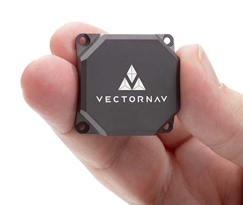
    Tactical Embedded series of GNSS/IMUs. (Photo: VectorNav)
    Tactical Embedded series of GNSS/IMUs. (Photo: VectorNav)

    Embedded navigation company VectorNav Technologies has introduced a new line of inertial products: the VectorNav Tactical Embedded series of GNSS/IMUs.

    Featuring a tactical-grade inertial measurement unit (IMU) and a multi-band GNSS receivers, the Tactical Embedded delivers milliradian attitude accuracy and centimeter-level positioning capability in a miniature 15-gram package.

    VectorNav’s Tactical Embedded line is in a new smaller size, and enables cost reductions for a wide range of autonomous pointing and geo-referencing applications. These include gimballed intelligence, surveillance and reconnaissance (ISR), SATCOM systems, lidar mapping and photogrammetry, among many others.

    The Tactical Embedded line supports external SAASM GPS for defense applications in ISR, electronic warfare, munitions and UAV navigation.

    “The Tactical Embedded is the culmination of years of development to bring milliradian-level attitude performance and robust positioning into a form factor that represents a disruptive step in inertial navigation capability,” said VectorNav President John Brashear. “Systems integrators worldwide can now embed tactical-grade inertial navigation capabilities into their electronics, unlocking a range of new applications and possibilities.”

    Designed and engineered at VectorNav’s AS9100-certified facility in Dallas, Texas, the Tactical Embedded line includes the VN-110E IMU/AHRS, the VN-210E GNSS-aided inertial navigation system (INS), and the VN-310E Dual Antenna GNSS/INS.

    Highlights include:

    • 0.05-0.1° heading; 0.015° pitch and roll
    • 1 m horizontal and 1.5 m vertical position accuracy
    • 1 cm RTK positioning accuracy
    • < 1°/hr gyro in-run bias; < 10 μg accel in-run bias
    • 184 channel, L1/L2/E1/E5b GNSS receiver
    • Support for external RTK, PPK and SAASM GPS
    • High update rates (800 Hz IMU; 400 Hz Nav)
    • Miniature footprint: (< 15 grams; 31 x 31 x 11 mm)
    • Low power: < 480 mA @ 3.3 V

    The Tactical Embedded line is available for purchase now and ships within two weeks.

  • The GPS Innovation Alliance adds BAE Systems as member

    The GPS Innovation Alliance adds BAE Systems as member

    The global security, defense and aerospace company joins alliance dedicated to protecting, promoting and enhancing the use of GPS technology

    GPSIA logoThe GPS Innovation Alliance (GPSIA) is welcoming BAE Systems Inc. as the newest member of the organization. BAE Systems, a global defense, security and aerospace company, joins member companies John Deere, Garmin, Trimble, Lockheed Martin and Collins Aerospace, a unit of Raytheon Technologies Corp., as well as 11 national organizations that make up GPSIA’s affiliates program.

    As the newest member of the alliance and the third aerospace and defense corporation to join the organization in eight months, BAE Systems will work with GPSIA to support its goal of enhancing GPS innovation, creativity and entrepreneurship — while advocating as the voice of the GPS industry in Washington.

    Logo: BAE Systems“We are excited to welcome BAE Systems as the newest member of the Alliance — a monumental addition that marks the doubling of our membership in the past eight months,” said GPSIA Executive Director J. David Grossman. “The continued growth of GPSIA demonstrates the criticality of protecting GPS and the substantial value our organization delivers through advocacy, information sharing, and technical standards. We remain committed to ensuring the economic and societal benefits of GPS are fully realized.”

    BAE Systems is a global leader in designing and implementing high-end technology to extend the reach and significance of GPS in defense. BAE Systems’ radiation-hardened electronics have been on board satellites and spacecraft for almost 30 years and are currently providing the high-performance onboard processing capability for the GPS III satellite mission. Promoting space resiliency for over 30 years, BAE Systems is a cornerstone of the growing importance of GPS technologies on the space frontier.

    BAE Systems has not only pioneered critical technologies suitable for GPS applications in space, but has also developed, manufactured, integrated and supported GPS receivers and guidance systems for advanced military applications on land, sea or air.

    The company was instrumental in the development of NAVWAR sensor technology, intended to meet growing challenges associated with maintaining military positioning, navigation and timing (PNT) advantage using satellite navigation, and has engineered top-tier jammers and navigation systems for decades. Their work has been critical in securing the safety and technological supremacy of our nation’s defenses.

    “GPS is an essential part of our world — from our infrastructure and economy to the security of our nation,” said Frank Ruggiero, senior vice president, government relations, BAE Systems. “As a leading provider of defense electronics and communications systems, we are excited to join the GPS Innovation Alliance to expand the development of cutting-edge GPS technologies.”