Enables greater collaboration and faster product development through I/Q data streaming
Spirent Federal Systems has released SimIQ, software that allows for earlier and more efficient GNSS testing during product development.
From software-in-the-loop through to final-form testing, SimIQ enables developers to collaborate across the full design lifecycle through the creation, sharing and replay of I/Q data files.
“SimIQ Capture allows developers to test their receiver algorithms in the earliest stages of design, minimizing costs and giving designers confidence as they proceed to the hardware design phase.”
SimIQ has been developed to meet the growing need to test GNSS capabilities earlier to accelerate product development, while simultaneously reducing costs by identifying issues prior to the purchase of hardware components.
For developers using Spirent’s GSS9000 and GSS7000 simulators, SimIQ extends multi-frequency, multi-constellation simulation capabilities to cover software-only testing needs through the capture and replay of high-fidelity I/Q data files.
Housed in a single system, SimIQ reads and generates I/Q data with two major components, SimIQ Capture and SimIQ Replay.
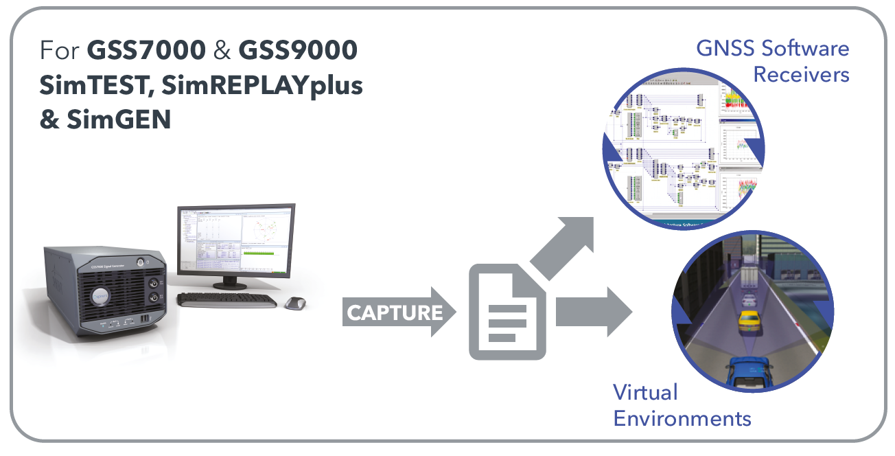
SimIQ Capture. Allows Spirent GNSS simulators to generate I/Q files containing all the GNSS signal data required to test the algorithms, conformance, and performance of software receivers. It enables the recording of GNSS I/Q data into files hosted in the simulator, helping development and testing teams to validate positioning, navigation and timing (PNT) algorithms before expensive hardware designs.
SimIQ Capture: Record I/Q data from Spirent GNSS simulators into files. (Image: Spirent)
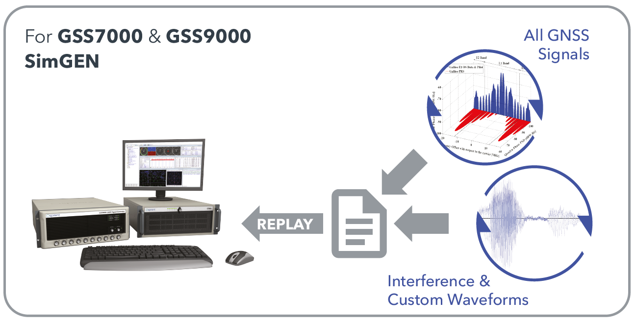
SimIQ Replay. Enables the simulator to read any I/Q file containing GNSS data. In addition, it facilitates the generation of RF from pre-recorded interference signals and custom waveforms. The flexibility and unrivalled signal generation architecture of Spirent’s hardware enables the generation of these signals from I/Q files, while maintaining fidelity and quality due to Spirent’s unrivalled signal generation architecture.
SimIQ Replay: Generate RF with Spirent GNSS simulators form I/Q files. (Image: Spirent)
Test engineers can accelerate development, and thus save time and resources, by using Spirent simulators during the entire design lifecycle. The new software will bring significant benefits to developers in the defense and aerospace sectors.
“SimIQ Capture allows developers to test their receiver algorithms in the earliest stages of design, minimizing costs and giving designers confidence as they proceed to the hardware design phase,” said Jen Smith, Spirent Federal’s director of Business Development.
SimIQ will be available to new and existing customers beginning in the fourth quarter of 2020.
Recent GPS World webinars have focused on a variety of proven, resilient technologies to combat GNSS and positioning, navigation and timing (PNT) vulnerabilities in critical infrastructure.
Now a Sept. 17 GPS World webinar focuses on how PNT monitoring can further protect critical systems from these vulnerabilities through continuous monitoring and improvement.
The Orolia-sponsored webinar is free. It is scheduled for 1 p.m. EDT / 10 a.m. PDT / 7 p.m. (1900h) Central European Time. Register here.
Protecting critical infrastructure is now a national priority for the U.S. and allied countries. Similar to cybersecurity for network systems, effective GNSS and PNT protection involves identifying and monitoring weak entry points, knowing where and when an intrusion occurs, and providing data about new threats to help strengthen the system going forward. Its value applies across all critical infrastructure sectors such as telecom, power grids and data centers.
Webinar speakers include:
John Fischer Vice President, Advanced R&D, Orolia
For more than 15 years, Fischer has been part of Orolia where he works with global navigation satellite systems, wireless, positioning navigation and timing, as well as specialized systems for its customers. Prior to joining Orolia, he specialized in wireless telecom as a founding member of two startups: Aria Wireless in 1990 and Clearwire Technologies in 1997. At Clearwire, he served as chief technology officer in creating wireless broadband equipment for internet connectivity. Early in his career, Fischer worked as a systems engineer in radar, EW, and command and control systems at Sierra Research and Comptek Research. He holds master’s and bachelor’s degrees in electrical engineering and computing engineering from the State University of New York at Buffalo.
Tim Frost Strategic Technology Manager, Calnex Solutions
Tim Frost is a specialist in next-generation synchronisation techniques, having worked with Zarlink Semiconductor, Symmetricom and now Calnex Solutions on packet-based synchronisation technologies. He is an active contributor to the ITU-T, and has also contributed to the AVnu Alliance, Small Cell Forum, Metro Ethernet Forum and IETF. He has a BSc. in Electrical and Electronic Engineering from the University of Leeds, and a MSc. in Computer Systems Engineering from the University of Manchester.
Francisco Girela Americas Tech Responsible, Seven Solutions
Francisco Girela is the Americas Tech Responsible at Seven Solutions. He holds a Master’s degree in Telecommunications Engineering from the University of Granada. After some time in the private sector, Francisco joined the Timing Keepers group at the same university as a researcher. During his research, he specialized in ultra-accurate time transfer systems and he focused on the development of the White Rabbit technology. He combines his work for Seven Solutions with his studies for a Ph.D. in Telecommunications Engineering. This combination has provided Francisco with a strong technical background on high-accuracy time synchronization and deep knowledge on timing applications in industrial sectors.
The ANT Center is a forward-looking research center within the AFIT seeking to identify and solve tomorrow’s most challenging autonomy and navigation problems.
The ANT Center’s goal is to develop navigation technology that ensures the Department of Defense (DOD) can navigate anywhere, anytime, using anything, and to improve the DOD’s ability to conduct autonomous operations.
Alion will research, assess, analyze and develop the ANT Center’s research in autonomous and cooperative systems, non-GPS precision navigation, and robust GNSS navigation/Navigation Warfare (NAVWAR). This effort supports the AFIT’s mission to advance air, space, and cyberspace power for the nation, its partners, and our armed forces by conducting relevant defense-focused research to enhance technical graduate and continuing education, while supporting the development and evolution of navigation and autonomy technologies, impacting weapon systems across the DOD.
“Alion has some of the greatest engineering and technology minds in industry partnering side-by-side with our customers to face challenging issues and create technologies, solutions and advancements in innovation to keep our nation ahead,” said Eric Wright, Alion’s vice president of the Integrated Solutions Operation within the Advanced Technology Group. “We are privileged to be working with the U.S. Air Force Institute of Technology to achieve the goals of the ANT Center.”
This task was awarded under the Department of Defense Information Analysis Center Multiple Award Contract (IAC MAC) issued by the Air Force Installation Contracting Center. This material is based upon work supported by the DOD Information Analysis Center Program Management Office (DOD IAC PMO), sponsored by the Defense Technical Information Center (DTIC) under Contract No. FA807518D0002.
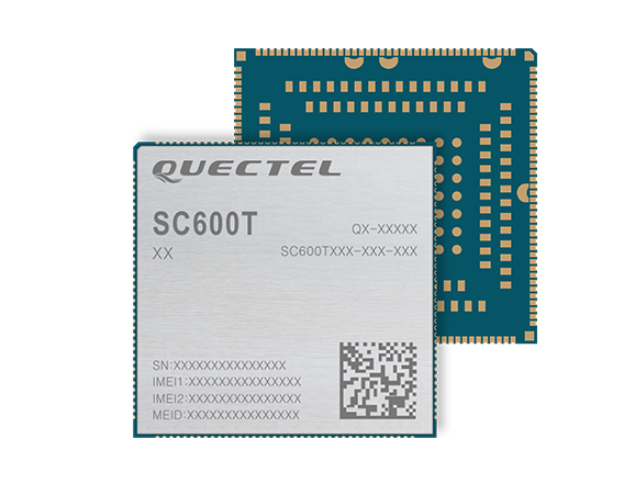
The SC600T-NA and SC600Y-NA are industrial-grade LTE Cat 6 modules with an operational and certified built-in Android 9.0 OS.
The SC600T-NA is based on the Qualcomm Snapdragon MSM8953 and supports Octa-core A53 up to 2.0 GHz, camera 24 MP and video 4K at 30 fps.
The SC600Y-NA adopts the Qualcomm Snapdragon SDM450 and Octa-core A53 up to 1.8 GHz, camera 21 and video 1080 at 60 fps.
A multi-constellation GNSS receiver is available in both modules, which is ideal for applications that require fast and accurate fixes, such as in-car video streaming and live video devices, the company said.
Both modules integrate 2 GB LPDDR3 + 16 GB eMMC flash and support WUXGA display.
With powerful engines, the two modules are fully integrated with Bluetooth, Wi-Fi capability and strong multimedia functions include support for dual LCDs and dual touch panels with independent display and operation. The modules can support a maximum of four cameras with two working simultaneously. Quick Charge 3.0 technology can facilitate various smart devices, including vending machines, smart cash registers, smart delivery machines and more.
Designed for North America, both modules work on FDD-LTE bands B2/B4/B5/B7/B12/B13/B14/B17/B25/ B26/B66/B71, TDD-LTE band B41 and WCDMA bands B2/B4/B5.
“These two modules for North America have passed another industry milestone. They will enable IoT designers, manufacturers and their customers to utilize the latest and leading LTE network technologies from America’s most awarded network,” said Patrick Qian, chairman and CEO of Quectel. “The new generation Cat 6 smart modules are critical for devices to utilize the processing power whenever needed.”
The global LoRaWAN market is projected to reach US$5557.2 million, growing at a very high compound annual growth rate (CAGR) of 47.2% during 2019 to 2027, according to market research firm InForGrowth.
LoRaWAN is mainly designed for wide range and low-power communications in smart city applications that benefit from wireless battery-operated devices and secure bi-directional communication, mobility and localization services.
InForGrowth’s LoRaWAN market report provides a detailed analysis of global market size, regional and country-level market size, segmentation market growth, market share, the competitive landscape, sales analysis, impact of domestic and global market players, value-chain optimization, trade regulations, recent developments, opportunities analysis, strategic market growth analysis, product launches, area marketplace expanding and technological innovations.
Top driving factors
The report discusses these driving factors in the LoRaWAN market.
Growing adoption of smart devices (IoT) in smart cities and smart home projects.
The growing adoption of machine-to-machine communication devices due to low cost and less power consumption.
Due to the use of IoT in various applications such as smart metering, smart lighting, and livestock monitoring, organizations face challenges regarding the selection of an appropriate connectivity option for specific business use cases.
LoRaWAN mainly the private or virtual networks, and connect different endpoints that use different applications (IoT, M2M, smart cities, sensor networks, and industrial automation) in a single data environment. This fuels the demand for LPWANs that offer requisite connectivity, provide long-range access, and extended battery life for connected devices and sensors.
Market segmentation
The global LoRaWAN market has been segmented on the basis of deployment, hardware, application and end-user.
The application of LoRaWAN is based on industry verticals segmented into
asset tracking
smart metering
smart parking
smart waste management
smart building
others.
Top-end users — those receiving benefits through the LoRaWAN market — can be segmented into
agriculture
utilities
consumer electronics
healthcare
manufacturing
others.
Region Analysis
The market is classified into North America, Europe, Asia Pacific, Middle East, Africa and Latin America.
Europe dominated the market in 2018 and is anticipated to dominate the market in the coming years as well. This is mainly attributed to the rapid adoption of smart agriculture in the region. Large-scale macro-farms are being replaced by family-owned micro-farms across Europe.
Key players involved in the LoRaWAN market included in this study are Murata Manufacturing Co., Ltd., Link Labs, Microchip Technology Inc., Laird Connectivity, Semtech Corporation, SK Telecom Co. Ltd., Orange S.A. Senet Inc., Comcast Corporation and others.
Automotive technology company Veoneer Inc. and Qualcomm Technologies Inc. are working together to deliver scalable advanced driver-assistance systems (ADAS) and collaborative and autonomous driving (AD) solutions.
The platform will integrate Veoneer’s fifth-generation perception software and driving policy software with the current and future Snapdragon Ride portfolio.
Qualcomm Technologies intends to make this integrated SoC and software stack platform available to global automakers and Tier-1 suppliers.
Designed for Tier-1 automakers
The solutions will be powered by Veoneer’s next-generation perception and driving policy software stack and the Qualcomm Snapdragon Ride ADAS/AD scalable portfolio of systems on a chip (SoC) and accelerators. They solutions range from L1 to L4 systems, designed to create an open platform for Tier-1 suppliers and automakers.
Designed to address the growing complexities associated with developing ADAS, including safety compliance, the integrated software and SoC platform aims to address the growing needs of the automotive ecosystem for scalable and upgradable solutions, which require highly advanced and power-efficient compute, connectivity and cloud service capabilities across all vehicle tiers.
Veoneer will serve as a Tier-1 system integrator for the new solution, while continuing its current strategies, which include developing, selling and launching its full line of ADAS and collaborative driving products and systems.
2024 model vehicles
The open and programmable platform that both companies intend to develop will be designed to create alternatives for automakers and Tier-1s for more customization opportunities while also charting a course for next-generation automotive architecture evolution. The companies expect the integrated platform to be available through automotive Tier-1 suppliers or directly to OEMs for 2024 vehicle production.
Veoneer’s software stacks are automotive grade solutions designed to meet the requirements of automakers, regulators and rating agencies globally. It has received top performance ratings and enabled automakers to achieve 5-star safety ratings for European New Car Assessment Program (Euro NCAP) in 2018 and 2020.
The companies plan to launch a state-of-the-art automotive-grade, functional safety compliant and optimized platform, which will include a full range of optimized NCAP features and up to hands-free driving on highways and slow-moving traffic. The platform will be continuously upgradeable through over-the-air updates.
The next-generation software stack will be developed in a dedicated organization within Veoneer.
In January, Qualcomm Technologies announced its latest addition to the company’s growing portfolio of automotive products with the new Qualcomm Snapdragon Ride platform.
RedTail Lidar System’s RTL-400 delivers the trifecta
Summer is here, and with it comes the challenge of creating accurate topographic maps under tree canopies. The adoption of drone-based, 3D light detection and ranging — or lidar — is emerging as the go-to sensing technique to meet this challenge consistently, safely and cost effectively.
Designed specifically for use on small drones, the RTL-400 from RedTail Lidar Systems was developed with technology licensed from the U.S. Army Research Laboratory (ARL). The RTL-400 is designed to provide high-resolution 3D images of objects on the ground, flying at an altitude of up to 400 feet.
The RedTail team recently partnered with the West Virginia Department of Environmental Protection (WVDEP) Division of Mining and Reclamation to demonstrate the RTL-400’s ability to generate an accurate digital terrain model (DTM) under “leaf on” conditions. This can be challenging, because pulsed laser light needs to reach the ground to generate laser light ground returns.
One mission of the WVDEP Division of Mining and Reclamation is to assure compliance with the West Virginia Surface Mining and Reclamation Act and other applicable state laws. This task requires ongoing monitoring, mapping and assessment of sites across the state that are actively being reclaimed.
Originally utilizing photogrammetry to generate point clouds, the WVDEP was unable to create the accurate, under-canopy DTMs that they desired. Looking for an alternate method, they began to consider lidar.
The RedTail lidar team met with WVDEP representatives at a mine reclamation site in a remote area of south-central West Virginia. The terrain was a mixture of rolling hillside covered with grasses, brush and tree stands.
The RTL-400 demonstration flight mapped approximately 20 acres of the reclamation site in 12 minutes, flying at an altitude of 196 feet and a speed of 18 mph.
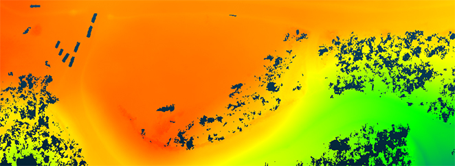
Once the data was collected, a digital terrain model (DTM) was created, revealing the RTL-400’s ability to generate the high-resolution, high-density point cloud needed to accurately map the terrain beneath the tree. 
Digital terrain model (DTM) generated from RTL-400 point cloud. (Image: RedTail)
The RTL-400 delivered all three key elements needed to provide DTMs in foliated areas:
a small beam divergence of 0.5 milliradians (.03 degrees) with a spot size of just 2 inches diameter at the canopy cover
the ability to analyze up to five returns from every transmitted pulse so that returns from the ground can be received and processed
a pulse density of 800 pulses in every square meter of the canopy (for the WVDEP flight). 
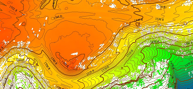
RTL-400 generated digital terrain model (DTM) overlaid with contour map. (Image: RedTail)
RedTail Lidar Systems is a division of 4D Tech Solutions Inc., a company focused on providing innovative technology-based solutions to address government and commercial customer needs. RedTail’s in-house technical expertise — coupled with a full suite of software and hardware design and manufacturing tools — allows the company to develop custom lidar solutions for manned and unmanned vehicle applications.
Spirent Federal Systems has been awarded a contract to support anechoic chamber testing for a major U.S. military agency.
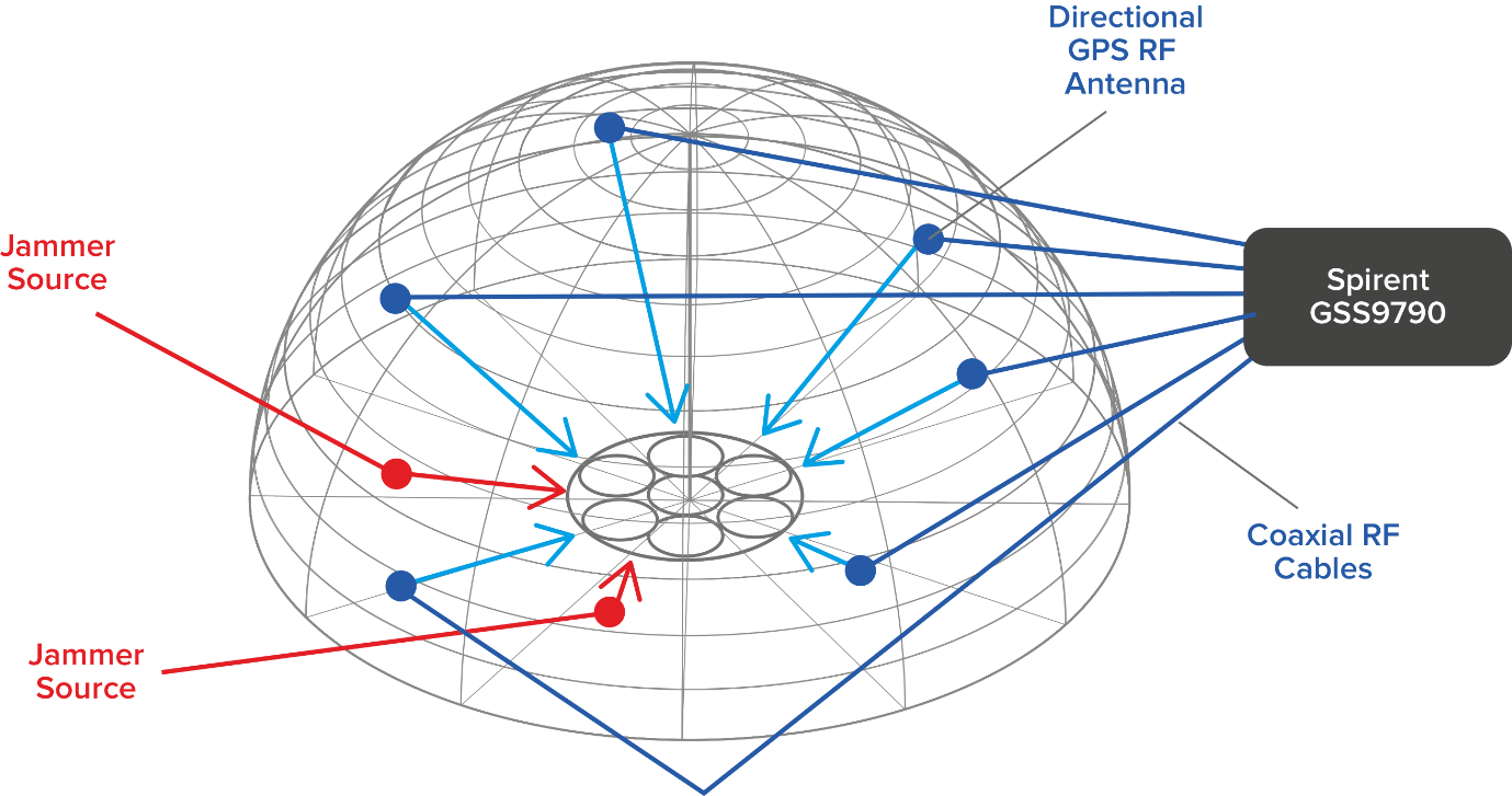
Spirent’s GSS9790 multi-output, multi-GNSS RF constellation wave-front simulator will be used as the signal generator attached to multiple transmission antennas for broadcast into the chambers.
Within this design, the antennas are structurally distributed to represent the correct arrival vectors of the simulated satellite signals on the device under test, creating the most realistic test environment possible. In addition, the GSS9790 supports interference sources located anywhere in the chamber to imitate different threat scenarios.
Image: Spirent
“Interference can threaten GNSS signals in multiple ways,” explained Jeff Martin, VP Sales. “We recognize the need for controlled, repeatable conditions to combat these threats. The GSS9790 delivers all the tools needed to successfully mitigate them.”
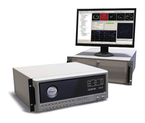
The GSS9790 simulator. (Photo: Spirent)
The Spirent GSS9790 supports classified Y-code, SAASM and M-code and can be found in key government labs across the country.
The Spirent GSS9790 enables verification of CRPA systems, spatial testing of single-antenna devices, and real-world-time-synchronized indoor GNSS implementations. The system is a development of the Spirent GSS9000. Combined with Spirent’s SimGEN software, it offers a powerful test platform for anti-jam and interference testing.
On Aug. 19, the U.S. Federal Communications Commission (FCC) granted a request for authorization from AT&T Services to use Galileo for emergency location purposes.
AT&T plans to use Galileo in conjunction with GPS to improve the accuracy of its E9-1-1 location services on mobile devices, and facilitate faster response from emergency services when wireless callers dial 9-1-1.
The request was approved by the FCC’s Public Safety and Homeland Security Bureau .
The FCC found that AT&T had satisfied the conditions for commercial mobile radio service (CMRS) providers to integrate foreign satellite signals into E9-1-1 services.
Under E9-1-1 requirements established in 2015, CMRS providers seeking to use foreign signals for E9-1-1 services must meet several conditions, including ensuring that integrating non-U.S. signals won’t cause interference with the E9-1-1 system.
Carriers also need to submit a signal integration plan including a mechanism to detect, mitigate and disable Galileo signals if they cause harmful interference.
The Federal Aviation Administration (FAA) plans to evaluate technologies and systems that could detect and mitigate potential safety risks posed by unmanned aircraft. The effort will be a part of the agency’s Airport Unmanned Aircraft Systems Detection and Mitigation Research Program.
The FAA Reauthorization Act of 2018 requires the agency to ensure that technologies used to detect or mitigate potential risks posed by unmanned aircraft do not interfere with safe airport operations.
The FAA plans to test and evaluate at least 10 technologies or systems. The evaluations are expected to begin later this year and will initially occur at the FAA’s William J. Hughes Technical Center, located next to the Atlantic City International Airport in New Jersey.
After the initial testing and evaluation in New Jersey, the agency expects to expand the effort to four additional U.S. airports. Those selections will be made at a later date.
According to the FAA, interested manufacturers, vendors and integrators of drone detection and/or mitigation technologies/systems will have 45 days to respond to its announcement.
In addition, the FAA expects to issue another solicitation in the coming weeks for airport operators interested in hosting the additional research and testing.
Huber+Suhner extends its Sencity rail MIMO antenna portfolio with dual-band GNSS services
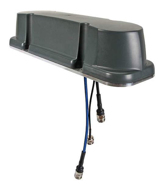
Huber+Suhner, an international manufacturer of components and systems for optical and electrical connectivity solutions, has extended the capabilities of its rail rooftop antennas with its launch of an embedded dual-band GNSS antenna that meets the railway industries’ stringent requirements.
Adding to its established Sencity rail antenna portfolio, the new multiple-input, multiple-output (MIMO) rooftop antenna enables railway operators to improve geospatial positioning and time precision of their operations.
Photo: Huber+Suhner
Supporting both the upper and lower GNSS bands, the antenna enables pinpoint location accuracy for the rigorous applications such as autonomous trains. With greater transparency of movement on the tracks, railway operators can improve the operational planning of densely crowded railway tracks and metro lines.
“The GNSS port on the antenna supports a higher number of satellite constellations,” said Daniel Montagnese, Huber+Suhner product manager for railway antennas. “This enables operators to improve signal acquisition time, as well as reducing the impact of obstructions in order to increase efficiency on the tracks.”
The GNSS port is complemented by two broadband cellular and Wi-Fi compatible ports that can be deployed for a variety of different train-to-ground services.
The Sencity MIMO rail antenna supports the GPS, Galileo, BeiDou and GLONASS constellations. Its robust design also meets the stringent EN 50155 railway standard and is fire retardant according to EN 45545-2 and NFPA130.
Huber+Suhner is a global company with headquarters in Switzerland which develops and manufactures components and system solutions for electrical and optical connectivity. With cables, connectors and systems — developed from the three core technologies of radio frequency, fiber optics and low frequency — the company serves customers in the communication, transportation and industrial sectors.
While connected cars provide wonderful advantages, their integration with cloud connectivity come with a heightened risk for cyber attacks.
Commentary by Alexander Meisel
When it comes to connected cars, automakers are innovating fast. Consumers are experiencing increasing amounts of futuristic features, be they passenger connectivity, automated speed regulation or autonomous driving capabilities.
However, these innovations and their integration with cloud connectivity come with a heightened risk for cyber attacks. A recent study conducted by U.K. self-driving hub organization Zenzic found that becoming cyber-resilient will be the biggest technical obstacle to successfully deploy self-driving cars on roads by 2030. This mountain will be a big one to surmount, and it’s only growing in size: The auto industry has seen a 94% year-over-year increase in hacks since 2016.
How can automakers prioritize security while keeping up with the demand for innovation in today’s connected cars?
Carmakers must consider security from day one
To make sure that security is built into the very foundations of a car, automakers must make it a priority from the first day of design. This focus is lacking amongst carmakers at the moment. In fact, 19% respondents to one survey said they don’t do enough security testing in the design phase, and only 28% said that they do a lot of the testing during the design stage.
Automakers can use design principles to build in security from the outset. For example, the principle of complete mediation allows for enhanced security as it ensures that a software stem “requires access checks to an object each time a subject requests access.” This means that attackers are only invited to exploit a system on one single occasion due to checks on subjects’ permissions.
Carmakers can also ensure that they are not sacrificing security by considering its importance when purchasing components from separate suppliers. These components must be specific enough to enable security in the system, but generic enough to allow for innovation.
Automakers must make cybersecurity a priority from the first day of design.
Here, companies can leverage the software engineering principle of interface segregation. This means that a shrunken, clear interface should be supplied by the vendor, so that the customer only uses the methods that are of interest to them.
In turn, this allows systems to remain decoupled and thus easier to then build a rich interface on top of. However, carmakers will have to stay on top of the security of the part in the development phase, and ensure that dormant functions are not abused by at least logging their execution once somebody tries to call them out of context.
Developers and cybersecurity experts must become a core part of the team
Software development is relatively new territory for carmakers. Now, cybersecurity is a key component of building connected cars, and automakers need to embrace developers that have expertise in this area and make them part of the core team.
This cultural change must be championed by the business leaders to allow car security to advance alongside the innovative features that the industry is building. This can be done by implementing DevSecOps ideology into the team, in order to “build the mindset that everyone is responsible for security.”
Car development teams will likely need a group of cybersecurity experts who can educate the rest of the developers and are willing to participate in the development process in order to check and implement safe and secure functions. If a company doesn’t have this kind of expertise in-house, they can partner with an expert third-party to help them along this journey.
Innovation and security can complement each other
Cybersecurity doesn’t mean sacrificing feature innovation: developments are being made in the field of security too, such as biometric technologies that can be integrated into car design.
For example, Blackberry’s QNX technology “has built in concepts for hardware and software trust validation, hypervisor to maintain a separation between the safety critical and infotainment systems, and a core operating system which passes all the functional safety standards,” according to the company’s senior VP SVP, head of QNX, John Wall. Innovation need not suffer at the hands of security, and vice-versa.
Potential AV thieves would first look to use GPS data to disable or falsify a car’s GPS system, making it untraceable.
In addition, the world’s leading electric vehicle provider, Tesla, ensures security in its cutting-edge, connected cars by sending security updates to cars’ operating systems overnight, and even providing awards for hackers that manage to hack its cars.
Looking ahead to the possibilities of autonomous vehicles (AV) that can drive passengers without needing to have their owner inside, innovation in GPS will be necessary to ensure security and accountability of the car. Potential AV thieves would first look to use GPS data to disable or falsify a car’s GPS system, making it untraceable.
However, carmakers can make this impossible for hackers by not just logging the data in its raw form, but also combining it with other car data using cryptographic algorithms. This ensures that the GPS data remains traceable even after the hardware has been taken apart and sold on the auto-parts black market. In this way, the signature of the original data combined with the GPS position adds an additional layer of security.
Integrating security into connected car design is no simple feat, but it’s a necessary one for carmakers that want to ensure the safety of their passengers while on the roads. By using design principles, diversifying expertise within development teams, and understanding that security and innovation need not be a trade-off, they can do just that.
Alexander Meisel is an automotive cybersecurity engineer at intive. He has a computer networking diploma from Hochschule Furtwangen University, and he has served as a CTO and Development Team Director in previous companies. He has experience with venture capital, successful M&As, and product and technical marketing strategies. He is also a public speaker at technical conferences and trade shows.