Category: Applications

  • Topcon offers RTK Thermal Mapper system for paving

    Photo: Topcon
    Photo: Topcon

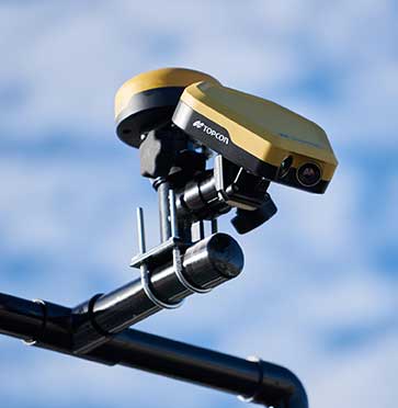
    Topcon Positioning Group is offering a new Thermal Mapper for asphalt paving. It is designed to monitor temperature segregation to prevent future problems and measure performance, as well as provide accurate compliance reporting — all with real-time kinematic (RTK) positioning accuracy.

    The mapper records temperature readings behind an asphalt paver as the paving is in progress and provides a visualization to operators in real time of whether the mix falls within a predefined temperature range, and if any segregation is limited within specifications.

    “If too much segregation occurs, roads will soon develop major problems. The mapper quickly tells operators if the mix is stable or if moderate or severe temperature variation is occurring. If the readings are unacceptable, operators can adjust for more efficient and accurate project outcomes,” said Murray Lodge, senior VP of construction. “The system’s sensors also bring to the market the first thermal mapping system with RTK GPS positioning for more accurate results than conventional methods.”

    The system also creates data reporting files to download for applications such as U.S. Department of Energy compliance through an interactive Pavelink module, the Topcon cloud-based logistics application for asphalt paving.

    “We are excited about where Topcon is taking the paving industry with the different solutions we are bringing to market. From SmoothRide, where we scan the existing road to determine the optimal design for variable depth milling and paving to the newly released Pavelink system, we are focused on improving paving.

    “Pavelink allows contractors to monitor the entire paving workflow from the batch plant, mixing plant, trucks, to the paver, to the rollers. By connecting the entire process, it allows the contractor to have full control over their projects in real time and make adjustments along the way, instead of after the fact as is so often done with conventional methods. Now, bringing in the heat sensor system into that workflow, we are giving contractors more resources to meet the specifications demanded today.

    “It is part of our commitment to revolutionize the planning and management of the asphalt paving process with real-time visibility throughout the project lifecycle,” Lodge said.


  • 19 countries track mobile location to fight COVID-19

    19 countries track mobile location to fight COVID-19

    In moves sure to concern privacy advocates, 19 countries are now accessing citizens’  mobile location data in an effort to fight the coronavirus outbreak.

    A COVID-19 Digital Rights Tracker by Top10VPN lists countries that are using mobile data for the pandemic. Uses range from anonymous aggregated data to monitor the general movement of people, to tracking the phones of individual coronavirus patients, to tracking suspected patients and their contacts, known as “contact tracing.”

    “In the past week we have witnessed a 90% growth in the number of countries implementing digital tracking measures and a 100% increase in reports of censorship,” reported Top10VPN on March 26.

    Actions by country

    Photo: AntonioGuillem/iStock / Getty Images Plus/Getty Images
    Photo: AntonioGuillem/iStock / Getty Images Plus/Getty Images

    In the United States, the Senate’s $2 trillion economic stimulus bill includes $500 million for the Centers for Disease Control (CDC) to launch a new “surveillance and data-collection system” to monitor the spread of COVID-19, reports Business Insider.

    Europe’s telecom companies are sharing location data with health authorities in Italy, Germany and Austria,  according to Reuters, to check whether people are remaining at home. The data is aggregated and anonymous, mapping concentrations rather than individuals to respect Europe’s privacy laws.

    In South Korea, the government created a map of cellphone data provided by telecom and credit card companies. The map was made public so everyone could track whether they’d been exposed, according to The Verge.

    According to reports, Iran used the COVID-19 epidemic to gather private data from its citizens “to boost Tehran’s surveillance capabilities,” reports Vice. The country sent a link to download the AC19 app with government endorsement, touting it as a way to determine whether users have the virus, but usage required sending back location data.

    In Taiwan, a mobile phone-based geo-fence uses location-tracking to ensure people who are quarantined stay in their homes, reports the New York Times. If the patient leaves their home address or turns off their smartphone, the police will visit within 15 minutes.

    SafePaths app

    The new Private Kit: SafePaths app, developed by Massachusetts Institute of Technology (MIT) researchers, is now available, though it is still under development. The downloadable app (for IOS and Android 8.0 and above) informs users if they’ve crossed paths with coronavirus patients, known through published data.

    “The solution is a ‘pull’ model where users can download encrypted location information about carriers so the users can self-determine their likely exposure to COVID-19 and coordinate their response with their doctor using their symptoms and personal health history,” according to a white paper about the contact-tracing app.

    The app takes privacy into consideration — COVID-19 patients consent to provide health officials with an accurate location trail once they are diagnosed. “Governments are equipped with a tool to redact location trails and thus broadcast location information with privacy protection for diagnosed carriers and local businesses,” the white paper reads.

    “Since the outbreak of COVID-19, governments around the world have implemented a range of digital tracking, physical surveillance and censorship measures in a bid to slow the spread of the virus,” warns Top10VPN. “Some of these may well be proportionate, necessary and legitimate during these unprecedented times. However, others have been rushed through legislative bodies and implemented without adequate scrutiny.”

  • US Coast Guard protests GPS disruption to UN body: ‘urgent issue’

    US Coast Guard protests GPS disruption to UN body: ‘urgent issue’

    The International Maritime Organization headquarters in London. (Photo: Anastasia Yakovleva/iStock Editorial / Getty Images Plus/Getty Images)
    The International Maritime Organization headquarters in London. (Photo: Anastasia Yakovleva/iStock Editorial / Getty Images Plus/Getty Images)

    Responding to a plea from 14 maritime organizations in the fall of 2019, the U.S. Coast Guard has protested disruption of GPS and GNSS signals to the International Maritime Organization (IMO).

    IMO is the United Nations body that coordinates and sets standards for international maritime operations and safety.

    In a paper dated March 10, the service said that GNSS signals are “essential to safe and efficient navigation and an integral component of all maritime operations.” Interfering with them “jeopardizes the safety of life at sea.”

    Deliberate disruptions in the eastern Mediterranean and the Black Sea, the paper says, affect vessels operating in international waters and engaged in innocent passage through territorial seas.

    While nations typically have a right to do as they wish in their sovereign territory, they are also obliged to not have that intrude into other nations’ territory or international waters. This is also true for vessels passing through their waters but not calling at their ports, known as “innocent passage.”

    The International Law of the Sea Treaty stipulates that, in the absence of some clear wrongdoing such as piracy, drug smuggling or discharging oil, vessels be allowed to pass through territorial seas unmolested by the coastal state.

    The Coast Guard paper also points out that nations have other treaty obligations that prohibit this kind of activity. International Telecommunication Union Radio Regulations prohibits “All transmissions with false or misleading identification…”

    Citing a March 2019 report in GPS World, the paper also documents that GNSS disruption is a global problem not confined to just one or two areas. A study by the German Aerospace Center (DLR) found interference during every phase of a vessel’s voyage between Europe and the Far East.

    The Coast Guard paper was submitted for consideration at IMO’s Maritime Safety Committee that had been scheduled to meet on May 13, but has been postponed due to the COVID-19 emergency.

    This planned consideration at IMO follows a resolution by the UN’s International Civil Aviation Organization (ICAO) in May 2019. In a paper entitled “An Urgent Need to Address Harmful Interferences to GNSS,” the International Federation of Air Traffic Controllers’ Association (IFATCA), the International Federation of Air Line Pilots’ Associations (IFALPA), and the International Air Transport Association (IATA) had introduced the issue.

    This resulted in a resolution describing the eliminating interference as an urgent need.

    About the same time the U.S .Coast Guard paper was due to be considered, IMO was to engage in the early stages of considering rules for autonomous vessels. Its Facilitation Committee was scheduled hold a “Regulatory scoping exercise for the use of Maritime Autonomous Surface Ships (MASS)” at a meeting the end of April. This meeting has also been postponed.

    While not specifically mentioned, navigation issues will undoubtedly be part of the considerations when discussion of rules for autonomous shipping eventually takes place.

    Public input to these international meetings is always sought in advance. For example, the U.S. State Department had announced a meeting for April 6 to receive public input on U.S. positions for the various issues to be discussed at the Facilitation Committee.

    While we understand that this meeting will also be also be postponed, comments can be submitted to the points of contact listed in the Federal Register announcement as well as be raised during the eventual meeting.

    Image: IMO Headquarters Wikimedia Commons

  • GPS tracking shows critical truck deliveries continue despite COVID-19

    GPS tracking shows critical truck deliveries continue despite COVID-19

    Photo: RichLegg/E+/Getty Images
    Photo: RichLegg/E+/Getty Images

    The American Transportation Research Institute released data showing that trucks are continuing to move — in many cases faster than usual — to respond to the demands placed on the industry by the COVID-19 pandemic.

    “ATRI’s real-time GPS data comes from more than a million trucks, allowing us to analyze freight flows, and so far in March, what we are seeing is an unprecedented level of truck movement,” said ATRI President and COO Rebecca Brewster. “Not only are trucks continuing to move, but they are doing so at speeds well in excess of normal traffic patterns.”

    For example, according to ATRI’s data, at the intersection of I-85 and I-285 in Atlanta, known locally as Spaghetti Junction, afternoon rush hour truck speeds are typically less than 15 MPH due to congestion. Last week, truck speeds averaged 53 MPH.

    “Spaghetti Junction is typical of what we’ve seen across the country, especially in areas hit hard by the virus and subject to quarantines and lockdowns,” Brewster said. “As other traffic dissipates, trucks continue to move, delivering much-needed relief supplies to markets, hospitals, gas stations and other essential businesses.”

    Among the hardest hit states, New York, California and Illinois, the data is showing similar changes.

    • In New York, along I-495 in Queens, the afternoon rush hour typically sees average truck speeds of 16 MPH. Speeds have now more than doubled, averaging 38 MPH, still below the posted speed limit but certainly an improvement.
    • In Los Angeles, at the intersection of I-710 and I-105, truck speeds during highly congested morning rush hours are normally less than 25 MPH between the hours of 6 and 8 a.m. Truck speeds are now averaging 53 MPH in the morning as Californians stay home but truck deliveries increase.
    • At the Byrne Interchange in Chicago, where I-290 intersects with I-90/I-94, morning truck speeds are now averaging 43 MPH, more than twice the typical morning rush hour speed of 20 MPH.

    According to ATRI’s analysis, the results can be explained by several COVID-19 related factors:

    1. The dramatic reduction in commuter traffic allows trucks to operate at higher speeds, particularly during traditional rush hours.
    2. Continuous 24/7 truck operations generate higher average truck speeds across nearly all hours of the day.

    ATRI’s analysis used truck GPS data from more than a million heavy-duty trucks and the locations examined included some of the nation’s top truck choke points.

    “Normally, ATRI’s bottleneck data is used to show us where the problems are on our highway system,” said American Trucking Associations President and CEO Chris Spear, “but during this period of extreme uncertainty, the data is showing us where the solution is — in the back of America’s trucks as professional drivers continue to quickly and safely deliver life-sustaining medical supplies, food, fuel and other essentials to Americans when they need it most.”

    ATRI is the trucking industry’s 501c3 not-for-profit research organization. It is engaged in critical research relating to freight transportation’s essential role in maintaining a safe, secure and efficient transportation system.

  • Garmin to use SiTime’s MEMS for timing

    Garmin to use SiTime’s MEMS for timing

    Logo: SiTime

    Garmin International Inc., a unit of Garmin Ltd., has chosen SiTime’s micro-electromechanical system (MEMS) timing solutions for several of Garmin’s automotive, aviation, marine, fitness and outdoor products.

    “Garmin makes products that are engineered on the inside for life on the outside,” said Patrick Desbois, Garmin executive vice president of operations. “Our innovation focuses on developing technologies that enable our customers to enrich their experiences as they pursue their passions. SiTime’s MEMS timing solutions help extend battery life across several of our product lines.”

    SiTime timing solutions are the heartbeat of customers’ electronic systems. With the deployment of 5G, internet of things (IoT) and automotive electronics in challenging outdoor environments, manufacturers will need timing solutions that enable environmental robustness and solve difficult challenges, such as power, size, and reliability. With the proliferation of electronic devices, the timing market is expected to grow to $10.1 billion by 2024.

    “Garmin creates products for active people,” said Piyush Sevalia, executive vice president of marketing at SiTime. “Precise time is at the heart of every GPS receiver and impacts the speed of signal acquisition as well as position accuracy.

    “Garmin’s outdoor products encounter many environmental stresses such as shock, vibration, rapid temperature changes and extreme temperatures. SiTime’s MEMS timing solutions are engineered to provide the highest level of robustness to such stressors and provide a powerful value-add to Garmin’s high-performing, robust and reliable products.”

  • Defense contracts spur growth of counter drone company

    Defense contracts spur growth of counter drone company

    Titan C-UAS systems are deployed globally, protecting combat forces, civilians, and critical infrastructure. (Photo: Citadel Defense)
    Titan C-UAS systems are deployed globally, protecting combat forces, civilians, and critical infrastructure. (Photo: Citadel Defense)

    U.S. military, government and international customers opt for Citadel’s Titan for drone protection

    Citadel Defense continues to experience rapid growth after being awarded several significant Defense and Homeland Security contracts for its C-UAS (counter unmanned aircraft systems) solutions.

    Malicious drone activity, ranging from single-use hostile small unmanned aerial systems to drone swarms continue to threaten safety and national security. Over the past 18 months, Citadel has received orders for more than $17.5 million in products and services to support anti-drone initiatives around the world.

    According to the company, the growth is a direct result of delivering reliable and effective force protection against individual drones and swarms for military, government and international customers over the past two years.

    Citadel Defense’s automated counter drone solution uses artificial intelligence and machine learning as a reliable and scalable approach for addressing emerging threats.

    To address the surge in global demand for Titan systems, Citadel has expanded its manufacturing capabilities in San Diego, California, to support production of up to 50 Titan systems a month. The company uses U.S. suppliers with more than 70% of components being sourced locally in Southern California to improve responsiveness when executing on urgent customer requests.

    As new drones are released to the market, Titan systems receive new software to address the new threats. If Titan’s AI algorithms do not detect the threat right away, the company explained that it can deliver an end-to-end capability in 72 hours for most drones and less than 4 weeks for the most complex drone signals.

    The use of AI, deepnets and adaptive countermeasures provide Titan with scalable force protection that can address the needs of the small unit, a large base or A mobile vehicle. The Titan system is being effectively integrated into layered solutions that combine radar, optics and kinetic countermeasures to help customers detect, identify, track, defeat and report on threat sUAS.

    “Designing agility into our product development process from the beginning has allowed us to iterate in real-time alongside our customers and rapidly deploy new capabilities to improve mission outcomes,” said Christopher Williams, CEO of Citadel Defense.

    As radiofrequency-based solutions become an important requirement for layered C-UAS solutions, Citadel has had its capabilities extensively evaluated by U.S. Army, Navy, Air Force, SOCOM, and DHS Test & Evaluation teams. Titan is being used to protect high-value assets in urban, rural and maritime environments.

    “Designing our system to meet unpredictable mission scenarios was made possible by direct feedback from operators experiencing drone incursions on the front lines,” explained Williams. “The threat environment is always evolving which requires a product development approach that can adapt and respond. A combination of human-centered design and AI-powered technology have helped Citadel differentiate ourselves from traditional defense contractors.”

  • Telstra partners with TEOCO on UAV strategy

    Telstra partners with TEOCO on UAV strategy

    Telstra logoAnalytics provider Teoco has been selected by Telstra — a mobile network in Australia — to assist with the development of its UAV strategy.

    Telstra will use Teoco’s AirborneRF solution to assess the readiness of its radio access network for future UAV applications, including communications, navigation, surveillance, safety and identity.

    Teoco is a provider of analytics, assurance and optimization solutions to more than 300 communication service providers (CSPs) and OEMs worldwide.

    Already deployed by several tier-one operators globally, AirborneRF ensures effective, mission-critical connectivity to enable effective traffic management and control for UAVs in the lower airspace. Telstra will use the solution to develop a platform for enabling a multitude of mission-critical services, vital in supporting successful UAV operations.

    The platform provides a link between cellular networks and aviation systems, such as air traffic management (ATM), unmanned traffic management (UTM) and flight information management systems (FIMS).

    TEOCO’s AirborneRF solution will play an important role in assisting Telstra enable a safe, equitable, secure and reliable urban air space platform. This has become all the more important to Telstra following Uber’s decision in 2019 to use Melbourne as one of three pilot cities to test out its “flying taxis” — the pilot is expected to begin this year, with commercial operations planned for 2023.

    Telecommunications companies can provide needed UAV services via their mobile networks. For the internet of things (IOT), they can provide drone registration, activation and identification. For 5G, they can provide super low-latency remote command and control and high-resolution video carriage.

    “We have been running a number of drone-related technology assessments with various industry customers, within law enforcement, humanitarian aid, post disaster, first responders and city councils, over the past 12 months,” said Thomas Neubauer, vice president of Business Development, TEOCO.

    “Commercial UAVs present a huge opportunity for [[telecommunications]] operators, but only if supporting mobile networks deliver the required connectivity to keep them airborne,” Neubauer said. “Mobile networks were not designed to meet the needs of the aviation industry, so tight focus is needed to guarantee the quality of service needed to safeguard the additional revenue that connected skies promise. Our Airborne RF solution offers this guarantee to a growing number of major operators around the world.”

  • Editorial Advisory Board PNT Q&A: 3D in construction

    What are the key obstacles to widespread adoption of 3D positioning and guidance in the construction industry?

    Ismael Colomina
    Ismael Colomina, GeoNumerics

    “Construction site monitoring with UAVs requires regulated standard scenarios that allow flying over people and in urban areas without spending weeks obtaining the needed permissions. It also requires the development of critical UAV components, especially the guidance, navigation and control (GNC) systems. Safe UAV navigation — guaranteeing positional accuracy with small probabilities of actual errors larger than the specified ones — is still under development and will involve a multi-sensor navigation system. Current GNSS augmentation systems, such as WAAS and EGNOS, may not be appropriate for flights in the very-low-level (VLL) airspace.”
    Ismael Colomina, GeoNumerics


    Members of the EAB

    Tony Agresta
    Nearmap

    Miguel Amor
    Hexagon Positioning Intelligence

    Thibault Bonnevie
    SBG Systems

    Alison Brown
    NAVSYS Corporation

    Ismael Colomina
    GeoNumerics

    Clem Driscoll
    C.J. Driscoll & Associates

    John Fischer
    Orolia

    Ellen Hall
    Spirent Federal Systems

    Jules McNeff
    Overlook Systems Technologies, Inc.

    Terry Moore
    University of Nottingham

    Bradford W. Parkinson
    Stanford Center for Position, Navigation and Time

    Jean-Marie Sleewaegen
    Septentrio

    Michael Swiek
    GPS Alliance

    Julian Thomas
    Racelogic Ltd.

    Greg Turetzky
    Consultant

  • iXBlue launches range of FOG-based INS for mobile mapping

    iXBlue launches range of FOG-based INS for mobile mapping

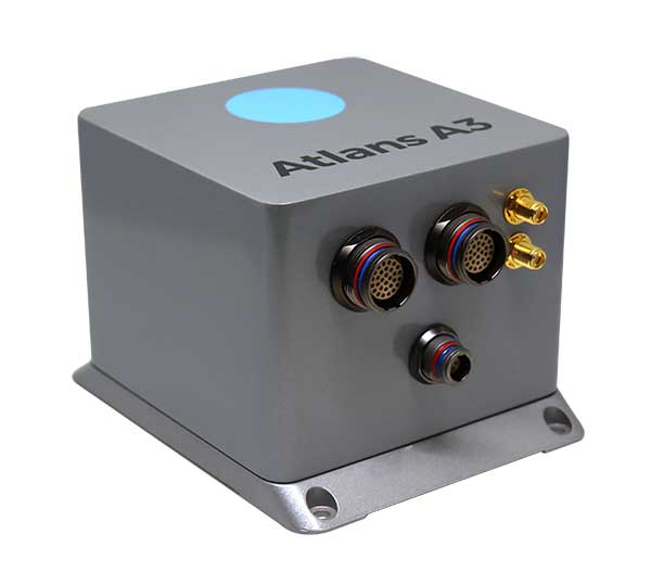
    The compact Atlans A3 INS. (Photo: iXBlue)
    The compact Atlans A3 INS. (Photo: iXBlue)

    iXBlue has launched a new range of FOG-based inertial navigation system (INS) dedicated to land and air mobile mapping applications, the Atlans Series. iXBlue is high-tech company specializing in the design and manufacturing of advanced navigation and georeferencing solutions.

    Based on iXBlue’s fiber-optic gyroscope (FOG) technology, the Atlans Series is a scalable range of north-seeking and north-keeping inertial navigation systems. They provide FOG performance to the full spectrum of land and air mobile-mapping applications and offer highly accurate positioning (up to 0.01 meter) in all conditions, including within GNSS-denied environments such as urban canyons, mountainous or forests areas.

    “Our existing high-grade Atlans A7 INS had already been adopted as the preferred georeferencing solution by leading U.S. companies operating in the pavement condition survey industry,” explained Marine Slingue, vice president, iXBlue. “Having identified the high potential of our technology for other land and mobile mapping applications, we decided to develop a complete range of scalable INS that each meet the specific requirements of every applications. With our new Atlans Series INS, we are now bringing the unrivaled georeferencing accuracy performance offered by the FOG technology to all land and air mapping applications, enabling robust and uninterrupted data-acquisition operations.”

    Quick and simple to install on all platforms, the new Atlans Series INS offers efficient “set-and-forget” operations for a wide range of land and air applications including asset inventory, pavement condition survey, vehicle automation, HD mapping, automotive testing, ground-truth, airborne surveys (UAVs, planes, helicopters), as well as precision pointing.

  • Exploring Shetland’s uninhabited Kame of Isbister with GNSS and UAV

    Exploring Shetland’s uninhabited Kame of Isbister with GNSS and UAV

    The mysterious and fascinating Kame of Isbister is situated in Shetland’s north mainland near the North Roe. The location has been studied several times, including by the Extreme Archaeology TV series in 2003. The uninhabited grassland continues to attract explorers because of a series of secret structures.

    Those structures are hidden on the sea-faced slope and can’t be seen from the land nearby. One theory posits that it’s an eremitical monastery settlement. The late Pictish/early Medieval site is hard to access — and that’s where drones coupled with GNSS receivers helped explorers.

    In 2019, Shetland Flyer Aerial Media in collaboration with Shetland College UHI and the Institute for Northern Studies explored the site. Their goals: create a 3D model of the headland as well as an orthomosaic and digital terrain model to identify and map the monastery structures.

    Because the site is hard to access, the team decided to use the DJI Phantom 4 RTK SUA (drone and base) with two flights. One flight captured both the Kame and a piece of the mainland for context, with a ground sample distance (GSD) of 2.4 centimeters/pixel (cm/px). The second flight was on a shorter GSD of 1.9 cm/px to capture detailed pictures of the cape and structures.

    Before the survey, the team used the Emlid Reach RS+ real-time kinematic (RTK) receiver to identify and establish the base mark for the drone on the mainland nearby.

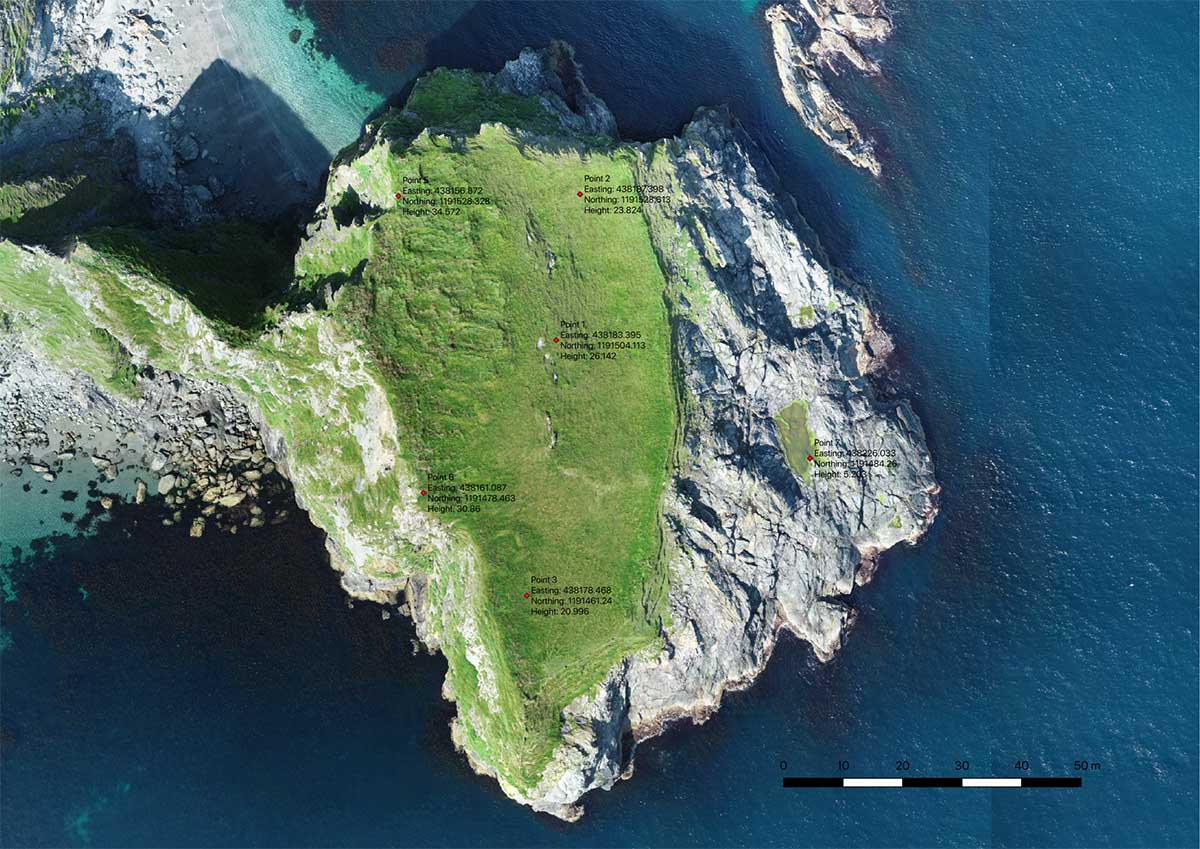
    Ground control point locations. (Image: Emlid)
    Ground control point locations. (Image: Emlid)

    The base mark was then post-processed using data from the OS Net reference station in Lerwick. Considering the long baseline (52 kilometers), it took the team four hours to observe the mark with Reach RS+. Later, when the archaeologists managed to climb the headland, the RTK receiver collected several noticeable control points.

    Creating the 3D model. During both flights, the drone’s base was sending corrections in RTK mode. In post-processing, horizontal accuracy of the processed map initially was within 10 cm with vertical at 15 cm. After adding the control points gathered with the RTK receiver, the error was reduced to 6.5 cm, significantly increasing the accuracy of the model.

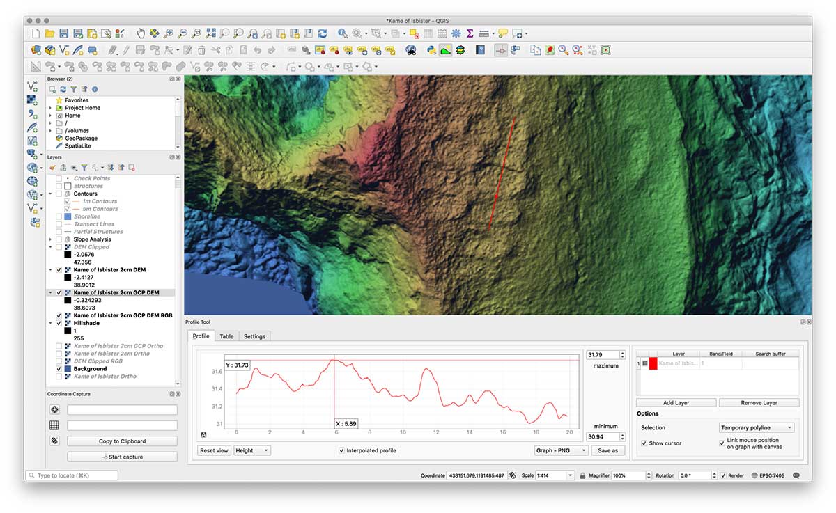
    The team performed the GIS processing in QGIS 3.4 LTR.

    Screenshot: Emlid
    Screenshot: Emlid

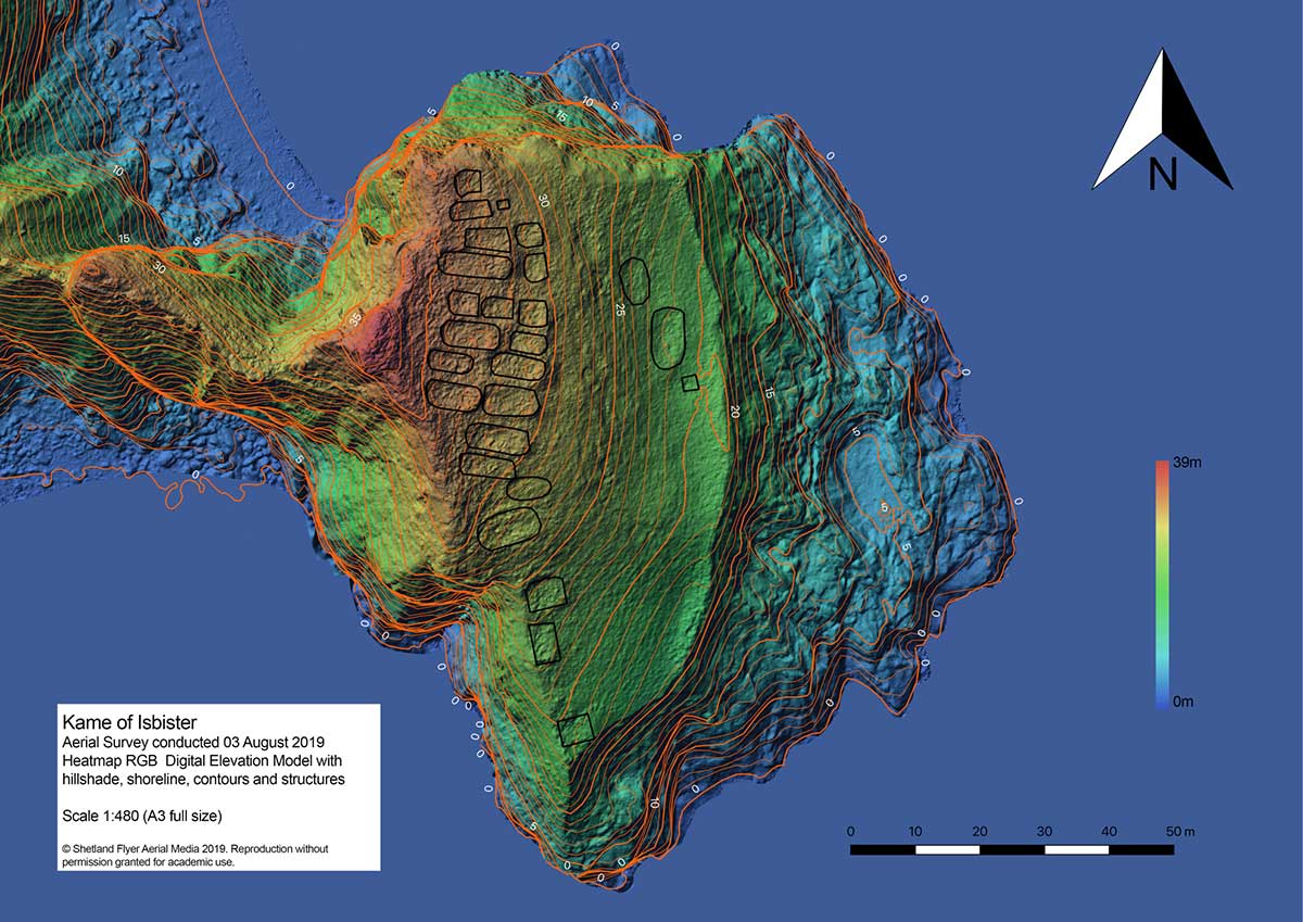
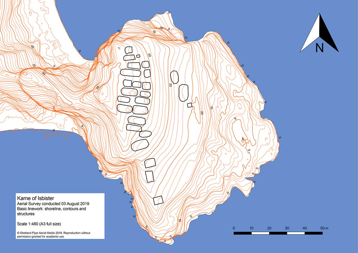
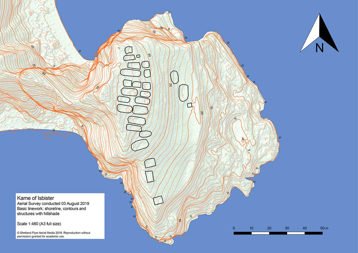
    Despite the long grass, they managed to distinguish each structure out of the orthomosaic using the 32-bit floating point raster digital elevation model (DEM). The team created a basic map with structures and contours, a hillshade version and a heat map.

    With proper preparation and setup, a GNSS RTK receiver with a drone can gather enough high-accuracy data to create accurate models and maps of an archaeological site — even if it’s hard to reach.

    Shoreline contours and structures. (Image: Emlid)
    Shoreline contours and structures. (Image: Emlid)
    Shoreline contours and structures with hillshade. (Image: Emlid)
    Shoreline contours and structures with hillshade. (Image: Emlid)
    3D model: The heatmap of the Kame of Isbister shows elevations and the archaeological site. (Image: Emlid)
    3D model: The heatmap of the Kame of Isbister shows elevations and the archaeological site. (Image: Emlid)
  • A drone can hear the shape of a room

    A drone can hear the shape of a room

    With a speaker and four microphones, drones can echolocate like bats

    Mathematicians at Purdue University in West Lafayette, Indiana, have found that drones can determine position with echolocation.

    The signal-processing research has potential applications for people, underwater vehicles and even cars, said Mireille “Mimi” Boutin, a Purdue University associate professor of mathematics and electrical and computer engineering.

    Boutin and Gregor Kemper, a professor of algorithmic algebra in the Department of Mathematics at the Technical University of Munich, have worked to reconstruct the wall configuration of rooms by using echoes picked up by microphones on the drone.

    Mathematicians found a method to hear the shape of a room using four microphones mounted on a drone. Pictured: Mireille Boutin. (Photo: Purdue University)
    Mathematicians found a method to hear the shape of a room using four microphones mounted on a drone. Pictured: Mireille Boutin. (Photo: Purdue University)

    When a microphone hears an echo, the time difference between the moment the sound was produced and the time it was heard is recorded. That time difference shows the distance traveled by the sound after bouncing on a wall — much like bats use echolocation to orient themselves with their surroundings.

    The challenge is to determine which distance corresponds to which wall, a process called echosorting. Sorting the echoes accurately ensures that all the walls heard are truly there. This way, the algorithm used does not produce “ghost” walls.

    The research is directly related to two complementary problems in engineering: localization (determining where you are in an environment) and mapping (determining the shape of your environment).

    The research, which uses methods from commutative algebra, proves that it’s possible for a minimal setup of four microphones arranged in a non-planar shape, along with a loudspeaker emitting a singal signal, to reconstruct a room.

    The microphones and loudspeaker could be mounted on a moving car, a robot navigating in an indoor environment, or an underwater vehicle exploring a wreck in the ocean. Some of these situations put restrictions on rotations and translations that can be applied to the microphone configuration. The impact of such restrictions on the reconstruction problem will also be studied in future work.

    The next steps will be to consider other scenarios, such as when the movement of the drone is restricted, or when the drone listens to the echoes of consecutive sounds as it is moving.

    Citation.
    “A Drone Can Hear the Shape of a Room,” by Mireille Boutin and Gregor Kemper, SIAM Journal on Applied Algebra and Geometry, 4(1), 123–140, Published online Feb. 6, 2020, https://doi.org/10.1137/19M1248534.

  • Analysis of satellite imagery shows reduced NO2 in China, Italy

    Analysis of satellite imagery shows reduced NO2 in China, Italy

    Screenshot: ESA video
    Screenshot: ESA video

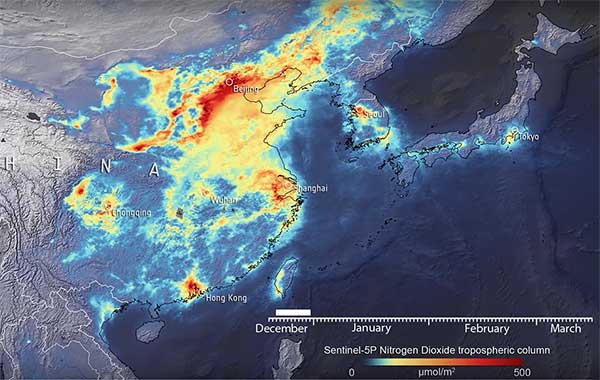
    Descartes Labs, a geospatial data analytics company, is using satellite imagery analysis to examine how the coronavirus reduced nitrogen dioxide (NO2) emissions in China.

    NO2 is produced by vehicles, power plants and heavy industries such as cement manufacturing, which were shut down during the coronavirus epidemic.

    Descartes Labs shared its visualization in a Facebook post. The visualization maps a time series of NO2 levels across Eastern China, Japan and the Korean Peninsula using data from the European Space Agency (ESA)  Sentinel-5P satellite.

    Plots of NO2 emissions from 2019 compared to 2020 show declines of nearly 60%. Read more on Descartes Lab’s blog.

    Copernicus data shared

    In a video provided by ESA, a drop in concentrations in late January is visible in China, coinciding with the nationwide quarantine; from the beginning of March, the nitrogen dioxide levels have begun to increase.

    Italy reduction

    Copernicus data also reveals the decline of air pollution, specifically nitrogen dioxide emissions, over Italy. This reduction is particularly visible in northern Italy, coinciding with its nationwide lockdown to prevent the spread of the coronavirus.

    “Satellites offer a unique vantage point to monitor the health of our planet,” said Josef Aschbacher, ESA’s director of Earth Observation Programmes. “Sentinel-5P is one of seven Copernicus satellites in orbit today. It currently provides the most accurate measurements of nitrogen dioxide and other trace gases from space.

    “As nitrogen dioxide is primarily produced by traffic and factories, it is a first-level indicator of industrial activity worldwide,” Aschbacher said. “What is clearly visible is a significant reduction of nitrogen dioxide levels over China, caused by reduced activity due to COVID-19 restrictions, but also the Chinese New Year in January. The Copernicus programme is a perfect example of how space serves all European citizens by combining the political strength of the EU with the technical excellence of ESA.”

    “We can certainly attribute a part of the nitrogen dioxide concentration reduction to the impact of the coronavirus,” said Claus Zehner, ESA’s Copernicus Sentinel-5P mission manager. “We currently see around a 40% reduction over Chinese cities, however these are just rough estimates, as weather also has an impact on emissions. We are conducting a detailed scientific analysis which will soon provide more insights and quantified results in the following weeks and months.”

    The Copernicus Sentinel-5 Precursor mission, also known as Sentinel-5P, is dedicated to monitoring air pollution by measuring a multitude of trace gases as well as aerosols — all of which affect the air we breathe.