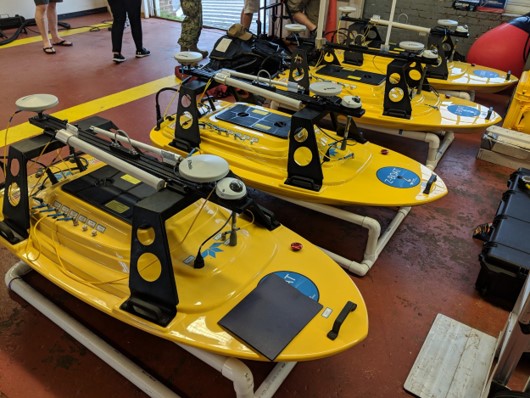
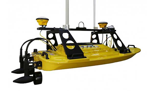
Teledyne Marine has released the Z-Boat 1800-T unmanned survey vessel, equipped with Trimble’s high-precision GNSS heading receiver and compatible with Trimble Marine Construction (TMC) software.
The Z-Boat 1800-T enables marine construction and dredging projects to run efficiently and be monitored in real time anywhere in the world.
The Z-Boat 1800-T, designed and manufactured by Teledyne Oceanscience, is a high-resolution shallow water hydrographic unmanned survey vehicle with the newly released Odom Hydrographic Echotrac E20 Singlebeam Echosounder and dual antenna Trimble BX992 GNSS heading receiver. Each sensor is integrated into a compact, portable and cost-effective package.
The combination of Trimble’s high-precision heading and positioning/guidance paired with Teledyne’s accurate/precise sonars allow for data collection under harsh conditions. Both sensors can be removed and mounted on other watercraft and barges to maximize data-collection capabilities.
The data is remotely viewable in real time, giving the operator full control and confidence. The boat’s small footprint allows access to areas that are too small, confined or unsafe for larger vessels.
Photo: Teledyne Marine
“Teledyne Marine and Trimble continue to create a paradigm shift for marine construction by providing real-time vision, guidance and survey across a project’s complete construction lifecycle — improving safety, eliminating or reducing work redoes, and helping to complete projects faster and under budget. This system provides as-building updates or what we call ‘eyes below the water,’” said Ted Germann, Teledyne Marine’s vice president of Emerging Markets.
“Trimble’s experience in GNSS guidance systems, and Teledyne’s leadership in shallow-water hydrographic surveying provides an ideal solution for marine construction contractors and surveyors,” said Kevin Garcia, general manager of Trimble Civil Specialty Solutions. “The Teledyne Z-Boat 1800T release means that near-shore construction workflows now have a quick mobilization tool to identify sub-surface obstructions, provide ad hoc inspections and increase site safety. This feature-loaded solution makes the unmanned surveying vessel affordable for all sizes of customers.”
No, I’m not talking about the line at the grocery store to buy toilet paper and hand sanitizer. Or the line at the doctor’s office. I’m talking about that gray privacy line invisible to the naked eye, but all too accessible on our mobile devices.
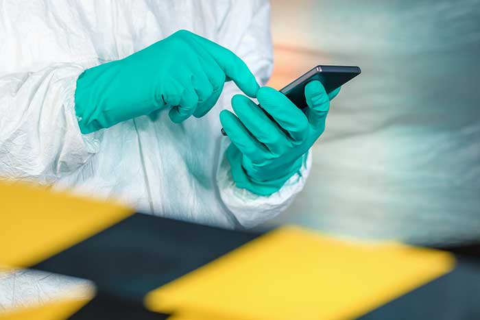
On March 16, Israeli Prime Minister Benjamin Netanyahu and his cabinet approved using citizens’ smartphones to track the locations of people infected with the novel coronavirus (COVID-19), as well as anyone they might have had contact with.
Such a strategy might work — some citizens reported receiving smartphone alerts when they were near an infected person. However, it does raise the ubiquitous privacy concerns of allowing your government to know your every move.
Some may think this an acceptable use of tracking, except that the Israeli Knesset — the citizenry’s representative legislature — was not involved in the decision. The tracking didn’t require a court order, and records were to be kept until the new regulation expired.
A few days later, Israel’s top court put a stop to the program, saying there would be no tracking of Israelis by the Shin Bet without Knesset oversight.
Of course, Israel is a democracy, and Netanyahu’s move is nowhere near the draconian measures undertaken by the Chinese government in response to the virus. Those actions included forcibly removing people from their homes and placing them in quarantine.
Yet China’s actions worked. As of press time, the outbreak there is under control, with no new cases reported on March 19. That’s impressive, if one can trust the state news. After all, this is the same country that warned the doctor who discovered the virus not to talk about it. Dr. Li Wenliang died in February of the disease.
Privacy versus public health: Something to think about while social distancing at home.
The World Health Organization (WHO) has launched a messaging service with partners WhatsApp and Facebook to keep people safe from coronavirus.
The messaging service has the potential to reach 2 billion people and enables WHO to get information directly into the hands of the people that need it.
From government leaders to health workers and family and friends, this messaging service will provide the latest news and information on coronavirus including details on symptoms and how people can protect themselves and others. It also provides the latest situation reports and numbers in real time to help government decision-makers protect the health of their populations.
The service can be accessed through a link that opens a conversation on WhatsApp. Users can type “hi” to activate the conversation, prompting a menu of options that can help answer their questions about COVID-19.
The WHO Health Alert was developed in collaboration with Praekelt.Org, using Turn machine learning technology.
Communities in need of resources can access location intelligence technology at no cost with six-month trial
Location intelligence company Esri is making its software available to public and private sector organizations fighting the coronavirus (COVID-19) pandemic.
The COVID-19 outbreak has escalated rapidly across the globe, and with municipalities struggling to respond, Esri has built out resources to help organizations understand the potential impact of the disease on public health, as well as potential community risk areas and their capacity to respond.
A COVID-19 GIS Hub site provides much of this essential data, including case locations and social vulnerability, that communities and health organizations can use to inform their response.
To help public health agencies and other organizations jump-start their response, Esri is providing the ArcGIS Hub Coronavirus Response template at no cost through a complimentary six-month ArcGIS Online subscription with ArcGIS Hub. The template includes examples, materials, and configurations to rapidly deploy a local ArcGIS Hub environment. ArcGIS Hub is a framework to build a website to visualize and analyze the crisis in the context of an organization’s or community’s population and assets.
“Esri has always prioritized assisting communities during large-scale emergencies and natural disasters,” said Jack Dangermond, Esri founder and president. “For the past 25 years, our Disaster Response Program provides data, software, configurable applications, and technical support for emergency operations. We consider it part of our mission to provide these services free of cost during this time of national crisis.”
For more information on the complimentary software and the disaster relief support, visit esri.com/disaster.
Klau Geomatics has released processing that brings precise point positioning (PPP) and post processed kinematic (PPK) together in an optimized solution.
The autonomous solution can work anywhere without any other user inputs, such as base station data and radio/GSM links, the company added.
According to Klau Geomatics, the solution works on its own to achieve high accuracy, regardless of the location of the user. Accurate datum and tectonic plate motion corrections, specific to different countries and regions, are automatically applied to deliver the most accurate solutions.
In addition, Klau Geomatics’ NRT technology gives users — specifically those in the drone inspection industry — the ability to attain absolute accuracy to analyze change over time on 3D assets, the company said. The precise corrections are applied to data from custom-tuned KlauPPK GNSS receivers in the KlauPPK post processing software to enable centimeter-level accuracy anywhere in the world without the need for RTK, CORS or local base station data.
Finally, Klau Geomatics’ hybrid terrestrial multi station and PPP algorithm are offering even more refined accuracy in areas such as the U.S., Europe, Japan, New Zealand and Australia. Data from as many as 15 reliable long-range CORS stations, where available, are applied to the processing. The enhanced PPP solution achieves 1-3cm XYZ absolute accuracy in many parts of the world.
The same KlauPPK software workflow applies, to synchronise camera events, apply lever arm corrections, manage coordinate systems and geoids, apply site localizations, capture ground points and more. Instead of choosing a base station, which should be within 20 miles of the site, or setting up an RTK radio link, users with an active KlauPPK subscription can process a high accuracy trajectory, anywhere, without any other inputs, Klau Geomatics said.
UPDATE: Israel’s High Court of Justice put a stop to the tracking on Thursday, March 19. The court declared that the Shin Bet security service may not track confirmed and suspected coronavirus patients if a Knesset panel to oversee this practice isn’t set up by noon Tuesday, according to Israel news agency Haaretz.
Israel’s internal security agency Shin Bet is using citizens’ smartphones to track the locations of people infected with the novel coronavirus (COVID-19) as well as anyone they might have had contact with, news agencies are reporting. Some citizens report receiving smartphone alerts when they have been near an infected person.
Privacy concerns. The tracking doesn’t require a court order and records will be kept until the regulations expire, according to Israeli news source Haaretz. The regulation can be renewed, and the country’s Health Ministry can keep the location records for 60 days after the regulation expires.
Israeli Prime Minister Benjamin Netanyahu told The New York Times that the government would approve the plan Monay night. “We have to maintain the balance between the rights of the individual and needs of general society, and we are doing that,” he told the newspaper.
No legislature involved. The plan was reportedly approved by cabinet members without approval of the Knesset, the Israeli legislature, which has just been sworn into office and has not yet convened.
The competition promotes the use of GNSS and Earth observation in European and African agriculture
The European GNSS Agency (GSA) is bringing back the Farming by Satellite Prize. Registration is now open for young innovators to explore the use of satellite technologies in agriculture to enable sustainable farming practices, improve efficiency and reduce the environmental impact.
The Farming by Satellite Prize is a joint initiative with the European Environment Agency (EEA), the European Union agency that provides independent information on the environment to decision makers and the public. The EEA also manages the Copernicus Land Monitoring Service and cross-service in situ coordination.
Innovation is crucial for the growth and sustainability of the agricultural sector, enabling it to respond to emerging global challenges such as the rise of the global population and the impact of climate change.
The Farming by Satellite Prize is designed to encourage young professionals, farmers and students in Europe to create new, sustainable and environmentally friendly solutions using Copernicus, EGNOS and Galileo.
The 2020 edition of the Farming by Satellite Prize includes the Special Africa Prize, which aims to encourage young Africans to develop satellite-based solutions able to cater to the specific needs and resources of communities and lands in Africa.
“Who would have thought that Galileo and Copernicus would have convinced the young farmers to become tech-savvy entrepreneurs bringing innovation gained by space data to improve quality of life,” said Pascal Claudel, acting executive director of the GSA. “We need young farmers to be innovative to develop a competitive and yet sustainable agriculture. Of course, they take advantage of what is available thanks to space technologies and our objective with this competition is to support them to reach the best possible solution.”
“It is clear that we need to make food production much more sustainable and lessen its impact on the environment and climate,” said Hans Bruyninckx, EEA executive director. “Satellite data, technology and innovation can support this change, which is why partnering with this initiative aligns well with the EEA’s commitment to protecting our nature, climate and human health.”
Applicants can take part as individuals or as a team and are invited to register online between March 16 and June 15. The top teams will be selected as finalists to enter the deep dive phase. A total prize purse of €10K will be distributed among the top four applicants.
The 2020 edition of the Farming by Satellite Prize is supported by industry partners with the sponsorship of CLAAS, a manufacturer of agricultural engineering equipment. Full details on the competition are available at www.farmingbysatellite.eu. Participants are invited to register early and submit their full written application before the registration deadline on June 15 deadline.
Genasys Inc., a global provider of critical communications solutions, has released an interactive map layer service for daily monitoring of Coronavirus – COVID-19 cases.
The company-created Web Map Service (WMS) displays daily spatial data from Johns Hopkins University. The data from reporting countries, which includes U.S. states and territories, tracks confirmed cases and other information.
“As a global provider of critical communications solutions, Genasys is strongly committed to providing information to help keep people safe during emergencies and crisis situations,” said Richard Danforth, chief executive officer, Genasys. “We are providing free use of our WMS feature to keep people informed and assist businesses with decisions regarding employee safety. Additional Genasys COVID-19 response initiatives are planned.”
Follow this link for more information and access to the interactive Genasys WMS: genasys.com/corona/
The unified Genasys Public Safety Mass Notification Platform provides a multi-channel approach to deliver geo-targeted alerts, notifications, instructions and information before, during and after public safety threats and critical business events. The Company’s end-to-end critical communications solution includes SMS, cell broadcast, email, social media and other mobile device emergency messaging.
Genasys systems are in service in 72 countries around the world in diverse applications, including public safety, national emergency warning systems, mass notification, defense, law enforcement and critical infrastructure protection.
A team of medical research and bioethics experts at Oxford University is supporting several European governments to explore the feasibility of a coronavirus (COVID-19) mobile app for instant contact tracing.
According to Oxford, the team has provided European governments, including the U.K., with evidence to support the feasibility of developing a contact tracing mobile app that is instant, could be widely deployed and should be implemented with appropriate ethical considerations.
“Coronavirus is unlike previous epidemics and requires multiple inter-dependent containment strategies,” said Professor Christophe Fraser from Oxford University’s Big Data Institute, Nuffield Department of Medicine. “Our analysis suggests that almost half of coronavirus transmissions occur in the very early phase of infection, before symptoms appear, so we need a fast and effective mobile app for alerting people who have been exposed. Our mathematical modeling suggests that traditional public health contact tracing methods are too slow to keep up with this virus.”
Fraser’s team at Oxford University’s Big Data Institute are continuing to simulate performance of the application so it can be adjusted to include mobile app guided coronavirus testing, and/or provide targeted responses in areas with particularly high rates of transmission, the university said.
“Current strategies are not working fast enough to intercept transmission of coronavirus,” Fraser said. “To effectively tackle this pandemic, we need to harness 21st century technology. Our research makes the case for a mobile application that accelerates our ability to trace infected people and provides vital information that keeps communities safe from this pandemic.”
Cesium’s 3D technology will power smart construction dashboard to make construction safer, more efficient and more profitable
Komatsu has officially announced an incoming suite of the company’s Smart Construction solutions, which will include the 3D visualization power and geospatial accuracy of Cesium, a platform to visualize, analyze and share 3D data.
“Together, Komatsu and Cesium are bringing a new era of innovation to the construction industry,” said Rod Schrader, Chairman and CEO of Komatsu’s North American operations. “As experts in 3D data visualization, computer graphics and open-source software, Cesium’s technology will help power our Smart Construction Dashboard.”
Komatsu made the announcement at ConExpo 2020, held in Las Vegas.
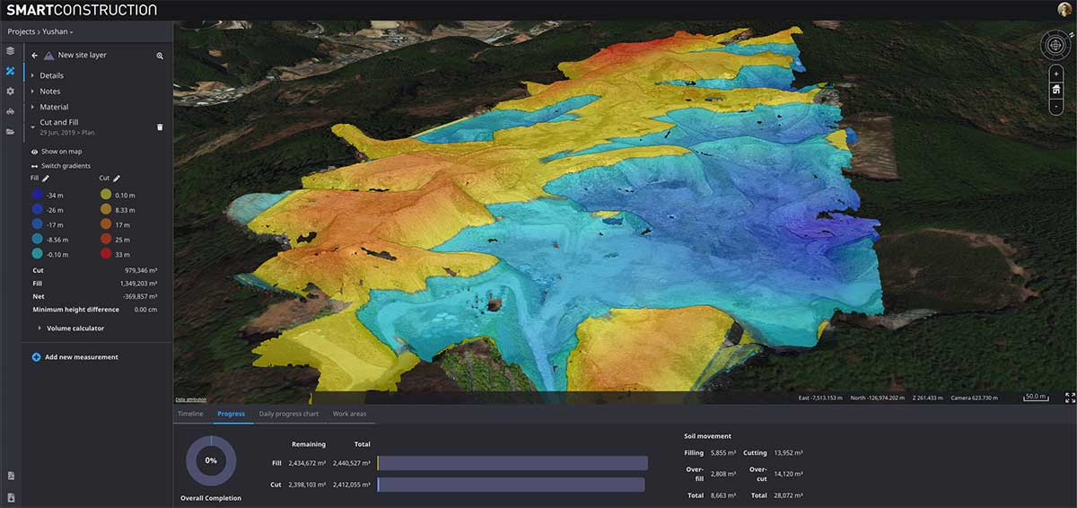
As the key strategic partner for 3D data visualization, Cesium built the company’s Smart Construction dashboard. The dashboard enables users to monitor a construction site from anywhere in the world, see how it changes over time and compare architectural plans with real-world data.
It is compatible with different types of data — collected from sensors on individual construction machines, drone surveys, or computer generated files like BIM/CAD models — allowing users to visualize them all in a single scene within a web browser, as well as calculate precise measurements for cut and fill, slope, contours and more.
As Komatsu noted today, the worldwide construction industry is on the cusp of rapid change and innovation driven by technology. Collecting data from people and machines — and connecting all of it across an open platform — optimizes processes and delivers insights that will enable customers to make data-driven decisions.
Komatsu chose to partner with Cesium because of its powerful 3D visualization engine and accuracy in tying data to precise locations on the globe. Cesium’s ability to keep millimeter-level accuracy while tracking satellites in complex orbits was important to attain the level of precision Komatsu’s Smart Construction initiative demands.
“We believe in Komatsu’s vision to create construction sites that are safer and more efficient through Smart Construction.” said Cesium CEO Patrick Cozzi. “We are proud that visualization and analytics with the hallmark precision of Cesium will provide technology for the industry’s digital transformation.”
Streaming 3D geospatial technology company Cesium will support the Smithsonian Institution by streaming 3D models of massive objects in its collection, such as the Space Shuttle Discovery. The models will be streamed over the internet in high resolution for the first time.
The collaboration is part of the Smithsonian’s Open Access Initiative. Through the initiative, the Smithsonian will release about 2.8 million 2D and 3D images, public collections metadata, and institutional research data sets as Creative Commons (CCo) for any purpose, such as education, research, commercial endeavors, creative reuse, computational analysis, and innovative explorations.
“The Smithsonian Open Access Initiative aligns perfectly with Cesium’s vision to make the world’s collection of data more useful and accessible,” said Cesium CEO Patrick Cozzi. “We are proud that our technology will give researchers, educators, and the public the ability to study 3D models in the Smithsonian’s collection in the highest resolution detail from anywhere in the world.”
Cesium Stories enable 3D storytelling
Cesium Stories enable creation and sharing of 3D geospatial presentations on the web, without requiring any writing of code. An intuitive interface enables story creation using Cesium’s 3D world terrain basemap, the user’s own 3D data, or a combination of multiple datasets, fused into interactive scenes. Learn more here.
Making massive high-resolution 3D models shareable begins at the intersection of Cesium’s core competencies of computer graphics, 3D data and open standards. With Cesium, glTF models are converted to 3D Tiles, an open specification developed by the company and adopted by the Open Geospatial Consortium (“OGC”) to make sharing massive amounts of 3D data as simple as sending a link.
Cesium develops, supports, and promotes open standards with organizations like the OGC and The Khronos Group to advance technology, encourage collaboration and fuel cross-disciplinary innovation.
The Space Shuttle Discovery — on display at the James S. McDonnell Space Hangar at the National Air and Space Museum’s Steven F. Udvar-Hazy Center in Chantilly, Virginia — is one of the largest objects in the Smithsonian’s collection. It is more than 122 feet long and weighs more than 4.5 million pounds.
Now, a shareable, high-resolution 3D rendering will enable anyone to rotate, zoom in, and study its details from anywhere in the world.
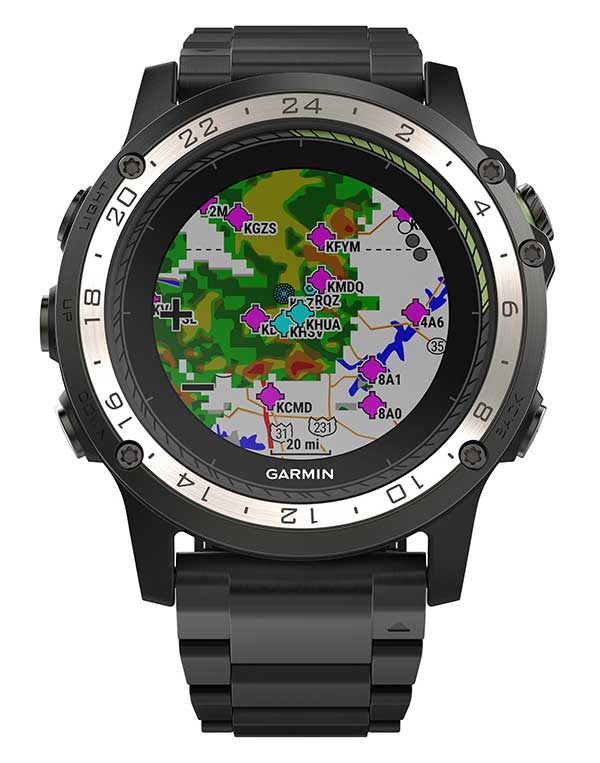
Weather radar overlay feature within Garmin D2 Charlie. (Photo: Garmin)
The U.S. Air Force is expected to take delivery of more than 100 D2 Charlie aviator watches for the specialized pilot group that flies the Lockheed U-2 aircraft.
Garmin’s D2 Charlie aviator watch has been selected by the United States Air Force (USAF) for use by the pilots of the Lockheed U-2 aircraft.
The high-sensitivity WAAS GPS-enabled D2 Charlie aviator watch incorporates global navigation capability, rich and colorful moving maps and more, providing pilots in the USAF with an exclusive, back-up navigation timepiece in the cockpit.
The watch receives both GPS and GLONASS signals.
U-2 for reconnaissance. The U-2 is a versatile, ultra-high-altitude reconnaissance aircraft used for intelligence gathering, research and communication purposes.
The U-2 provides high-altitude, all-weather surveillance and reconnaissance, day or night, in direct support of U.S. and allied forces. It delivers critical imagery and signals intelligence to decision makers throughout all phases of conflict, including peacetime indications and warnings, low-intensity conflict, and large-scale hostilities.
100 watches ordered. The USAF is expected to take delivery of more than 100 D2 Charlie aviator watches for the specialized pilot group that flies the Lockheed U-2 aircraft. With a service ceiling of 70,000 feet, the D2 Charlie will provide unique benefits such as barometric-based O2 alerting and GPS-specific features including track, distance to the next waypoint, estimated time enroute and more.
“Garmin is honored to have been selected by the United States Air Force to equip the men and women who fly one of the most iconic aircraft in the history of aviation,” said Carl Wolf, Garmin vice president of aviation sales and marketing. “The D2 Charlie aviator watch will be an integral and functional part of the U-2 pilot’s toolkit.”
A U.S. Air Force U-2 Dragon Lady flies a training mission. (Photo: U.S. Air Force photo by Master Sgt. Rose Reynolds):
Designed with pilots of varying backgrounds and missions, the D2 Charlie aviator watch features a colorful, dynamic moving map which depicts airports, navaids, roads, bodies of water, cities and more, offering greater situational awareness.
When the D2 Charlie is paired with Garmin Connect on a connected mobile device, pilots can view weather radar on top of the map display relative to flight plan information.
Pilots can also display estimated time enroute (ETE), universal coordinated time (UTC) or other pilot-selectable data fields overtop the map so it’s easy to monitor the progress of a flight and view pertinent flight information simultaneously.
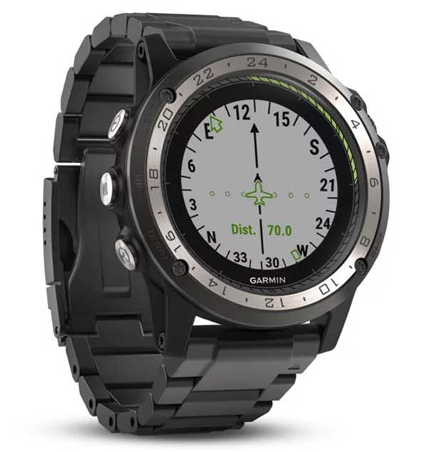
The Direct-to feature within D2 Charlie watch. (Photo: Garmin)
Standalone navigator. An advanced, standalone navigator, the D2 Charlie aviator watch incorporates exclusive navigation functions and capabilities, including dedicated direct-to and nearest buttons along the side of the bezel that allow the user to easily build or modify flight plans.
Airport information pages display communication frequencies, runway information (including dimensions and surface type), weather data and more for a specified airport.
The flight log page allows pilots to conveniently reference recent flights at their wrist, displaying date, flight duration, total distance and more of a particular flight. Additionally, improved flight planning capabilities include the option to add multiple waypoints within a single flight plan and the ability to navigate direct to any waypoint in a flight plan.
Heart-rate monitor. The D2 Charlie is made of premium materials, including a sapphire scratch-resistant crystal lens and a diamond-like carbon-coated titanium bezel for improved durability. A sunlight-readable, high-resolution color display with an LED backlight on the watch face allows pilots to view data in most lighting conditions in the cockpit.
The D2 Charlie offers up to 20 hours of battery life in GPS mode and up to 12 days in smartwatch mode.
Garmin Elevate wrist heart rate technology allows pilots to measure heart rate 24/7 alongside daily activity tracking. The D2 Charlie aviator watch also comes preloaded with a full multisport toolset for running, golfing, cycling, swimming, skiing and more. Water rated to 100 meters, it can also withstand swimming and other water activities. When paired with a compatible smartphone, customers can also view phone calls, text and email smart notifications at their wrist.