Category: Applications

  • ION seeks abstracts for 2020 JNC by Feb. 3

    ION seeks abstracts for 2020 JNC by Feb. 3

    ION JNC logoThe Institute of Navigation is asking for abstracts for the 2020 ION Joint Navigation Conference. JNC 2020 will be held June 1-3 at the Northern Kentucky Convention Center in Covington, Kentucky/Cincinnati, Ohio.

    The US ONLY CLASSIFIED sessions will be held June 4 at the Air Force Institute of Technology in Dayton, Ohio.

    Abstracts are due Feb. 3, 2020.

    JNC is the largest U.S. military Positioning, Navigation and Timing (PNT) technologies conference of the year with joint service and government participation. The JNC theme is Enhancing Dominance and Resilience for Warfighting and Homeland Security PNT.

    The event will focus on technical advances in PNT with emphasis on joint development, test and support of affordable PNT systems, logistics and integration with more than 150 operational presentations.

    Abstracts will be accepted through Feb. 3, 2020. For more information about JNC 2020, visit ion.org/jnc.

    Exhibit Opportunities
    JNC features a technical exhibit and showcase of guidance, navigation and control technology products and services. The exhibit hall (June 2-3) will be open to all conference participants, exhibiting organizations, their employees and related organizations.

    All materials displayed in the exhibit hall shall be publicly releasable (Distribution A). For more information on exhibiting, visitwww.ion.org/jnc.

    Attendance Restricted Technical Sessions
    Conference attendance for both FOUO US ONLY (June 1-3) and US ONLY Secret Clearance (June 4) sessions will be screened by the Joint Navigation Warfare Center and will be restricted to US ONLY. Advance visit requests and approvals are required for all technical participants.

    Quick Links for ION JNC 2020

  • VW Golf launches in Europe with NXP’s secure V2X technology

    VW Golf launches in Europe with NXP’s secure V2X technology

    Volkswagen and NXP to Deliver Safety to European Roads with Rollout of Communicating Car Technology

    NXP Semiconductors N.V., a provider of automotive semiconductors, has rolled out its RoadLINK V2X (vehicle to everything) communication solution in the new Volkswagen Golf.

    The recently released eighth-generation Golf is the first volume European car model equipped with V2X, offering a major boost to the deployment of the technology on European roads and beyond.

    Life-saving tech. The technology can prevent accidents by having cars communicate with each other, independent of car brands and without the support of cellular infrastructure.

    “Road safety forms the core of VW’s commitment to its customers. As a high-volume manufacturer we aim to be a pioneer in this space,” said Johannes Neft, head of Vehicle Body Development for the Volkswagen brand. “The introduction of V2X, together with traffic infrastructure providers and other vehicle manufacturers, is a major milestone in this direction. Volkswagen includes this technology, which doesn’t involve any user fees, as a standard feature to accelerate V2X penetration in Europe.”

    “Volkswagen has taken a bold step to seize the road safety initiative through the implementation of V2X,” said Torsten Lehman, senior vice president and general manager of Driver Assistance and Infotainment at NXP. “After proving our technology in more than one million test days globally, we are pleased that our RoadLINK technology, developed in cooperation with Cohda Wireless, was chosen to enable new levels of safety in Europe’s most popular car model, the new Golf.”

    NXP and Volkswagen have closely collaborated for high reliability and performance, as well as for standardization of V2X communication that addresses cybersecurity and privacy protection.

    V2X in Europe. Wi-Fi-based V2X is a mature technology that has been tested for more than 10 years. Today, 1,000 kilometers (km) of European roads are equipped with V2X technology based on Wi-Fi with 5,000 km planned through the end of 2019.

    Its research and development, testing and standardization has occurred within a strong global ecosystem of suppliers and car manufacturers to ensure reliability in diverse road and traffic conditions.

    Wi-Fi therefore forms the basis of the European standard that has been chosen for vehicle-to-vehicle and vehicle-to-infrastructure communication, according to NXP. An additional benefit is its availability independent of paid cellular services. Other developing cellular-based technologies can be added complementary to Wi-Fi-based V2X.

    Migration to autonomous. V2X communication is set to become a critical part of advanced driving assistance systems (ADAS) and the migration to autonomous cars that communicate with each other and with traffic infrastructure.

    The benefit of Wi-Fi-based V2X is its robust, low latency, real-time communication regardless of any car brands.

    • It enables awareness and communication between cars, road infrastructure like traffic lights or street signs, and other road users such as cyclists and pedestrians.
    • It is a technology that is collaborative, allowing it to “tap into” surrounding sensor data from mutually equipped cars to warn of hazards and prevent accidents.
    • V2X is a technology that complements other ADAS sensing technologies such as radar, lidar and cameras.
    • It helps vehicles to “see” more than a mile ahead and around corners to provide early warning of obstacles, hazards and road conditions.
    • It has the ability to “see” through objects, delivering more information than that obtained through line of sight only.
    • Its sensing capabilities are unaffected by poor weather conditions.
    Photo: Volkswagen
    Photo: Volkswagen
  • SimActive used to determine financial assistance after Hurricane Dorian

    SimActive used to determine financial assistance after Hurricane Dorian

    Photo: SimActive
    Photo: SimActive

    SimActive Inc., a developer of photogrammetry software, announces that its Correlator3D software has been used by Air Data Solutions (ADS) in Florida to determine financial assistance following Hurricane Dorian.

    Aerial imagery was collected before the storm for pre-hurricane assessment and after for damage analysis.

    A Phase One 100MP aerial camera owned by ADS was flown to gather high-resolution images of the affected areas. The data was then processed by SimActive software to create mosaics of orthophotos.

    The resulting geospatial data helped government authorities to calculate recovery aid funds.

    “We have been impressed by the accuracy and speed of Correlator3D to support such a time-critical mission,” said Don Cummins, President of ADS. “Combined with a high-end aerial sensor, SimActive provides the best tool for emergency response.”

    Air Data Solutions is an aerial, terrestrial, and aquatic data collection and modeling company.

  • Lidar USA offers new aircraft to carry full range of UAV scanners

    Lidar USA offers new aircraft to carry full range of UAV scanners

    Photo: Innoflight Technology
    Photo: Innoflight Technology

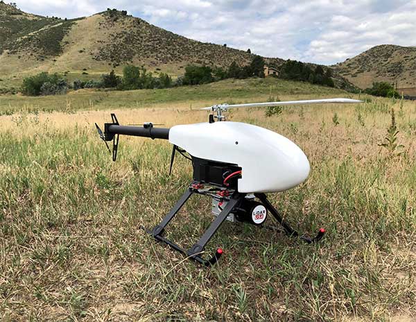
    Lidar USA is partnering with Innoflight Technology, a manufacturer specializing in UAV systems for surveying, mapping and inspection.

    As a result of the partnership, Lidar USA is offering the Galaxy 950 platform to carry any of its sensors while consistently providing flight times over 30 minutes.

    Based in Somerville, Alabama, Lidar USA specializes in the design and integration of economical lidar sensors.

    Innoflight and Lidar USA’s partnership is another step for both companies to offer turn-key solutions focused on quickly and safely acquiring high-quality data.

    Innoflight designed the Galaxy 950 to simplify the flying aspect of remote sensing with UAVs. The helicopter includes a parachute, automatic takeoff and landing, and extended visual-line-of-sight capabilities to maximize productive time.

    For corridor/electric utility line projects, the Galaxy 950 pairs well with the recently announced CL-90 by Teledyne Optech. As the first integration partner of the new compact lidar system, Lidar USA is offering maximum productivity at UAV flight ceilings while achieving improved canopy penetration and exceptional downward point density.

    “Lidar USA and Innoflight Technology are both committed to customer success, and this partnership provides the whole package for lidar mapping solutions with UAV,” said Jeff Fagerman, CEO of Lidar USA. “Innoflight’s Galaxy 950 offers exceptional performance in safety, flight duration, and ease of use, which is what our customers need for their projects.”

    The Galaxy 950 is now available from Lidar USA as an integrated package with any of their scanning systems.

  • Geneq launches SXPad 1500 rugged data collector

    Geneq launches SXPad 1500 rugged data collector

    The New Handheld Is Designed for Data Collection for Land Surveying and Geospatial Information Systems (GIS)

    Photo: Geneq
    Photo: Geneq

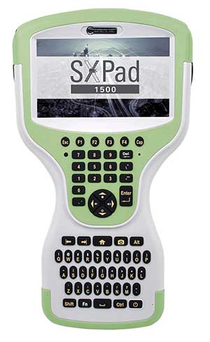
    Geneq Inc. has added a new data collector to its SXPad product line. The rugged SXPad 1500 data collector features a full alphanumeric QWERTY keypad and long-range Bluetooth, and was designed to meet the rigorous IP67 standard to deal with challenging field conditions.

    The SXPad 1500 and its 5-inch sunlight-readable touchscreen can be connected to any GNSS receiver or compatible robotic total station to ensure the success of all survey projects.

    Driven by a 1-GHz processor and the Windows Mobile 6.5 operating system, the field collector is a high-performance device designed to provide the power needed to work with maps and large data sets in the field, as well as many software solutions.

    With its integrated cellular modem and Wi-Fi standard, the SXPad 1500 offers wireless connectivity for internet access and GIS data transfer. This feature will be helpful for setting parameters and configuring the SXblue PREMIER and F90 or any real-time kinematic (RTK)-compatible GNSS receiver.

    The SXPad 1500 has a GNSS internal module that delivers adequate performance for certain GIS field data collections.

    Equipped with an internal memory of 1 GB (memory can be expanded to 16 GB with an SD card), the SXPad 1500 provides enough storage space for data recording. Users will benefit from its high-performance lithium battery allowing uninterrupted field operation for up to 8 hours.

  • Flowfinity and Leica Geosystems streamline high-precision GNSS data collection workflows

    Flowfinity and Leica Geosystems streamline high-precision GNSS data collection workflows

    Photo: Leica Geosystems
    Photo: Leica Geosystems

    Flowfinity Wireless Inc. has released new functionality that allows field users to collect highly precise GNSS location data via external Leica Zeno GG04 plus Smart Antennas in Flowfinity applications.

    This powerful new capability assists organizations in the engineering, environmental consulting, construction and public utilities sectors that use custom mobile data collection apps built with Flowfinity to survey and inspect work sites.

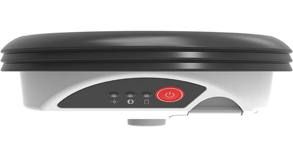
    The Zeno GG04 plus is a rugged, flexible and easy-to-use smart antenna from Leica Geosystems, part of Hexagon. It uses RTK technology and Precise Point Positioning (PPP) to make high-accuracy data collection possible in real-time even in demanding locations without the need for a mobile data connection.

    Photo: Flowfinity
    Photo: Flowfinity

    The combination of state-of-the-art Zeno GNSS technology with the workflow automation features in Flowfinity Actions is a game-changing update that will save hours in the field while providing location data accurate to five decimal places for analysis in the office.

    “This is an exciting update for any organization that needs to record accurate site survey data as part of their digital mobile workflows,” said Larry Wilson, VP Sales & Marketing, Flowfinity. “Field users in engineering and related industries can now collect some of the most precise GNSS readings possible and have that info available in their existing Flowfinity applications. This opens up significant opportunities to become more efficient on-site.”

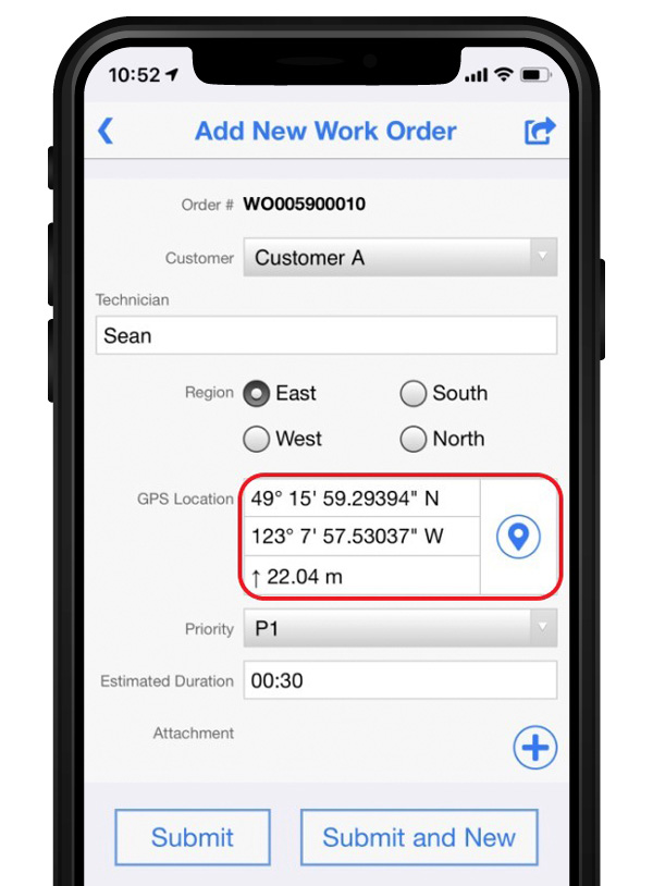
    All Flowfinity applications deployed on Android and iOS devices can now leverage the Leica Geosystems antenna to achieve 5 decimal place accuracy for GNSS location data.

    For example, if an environmental consulting firm needs survey quality GNSS data to be collected and submitted during site inspections, they can now deploy field workers with Leica GG04 plus Smart Antennas to record data directly into their Flowfinity mobile applications, rather than performing manual data entry or relying on much less precise data from internal mobile device sensors.

    Flowfinity is used across industries including environmental services, engineering, construction, municipal governments and utilities for driving efficiency and streamlining operational workflows.

    Go here for complete list of new features.

  • 3GPP approves NaVIC for global commercial use

    3GPP approves NaVIC for global commercial use

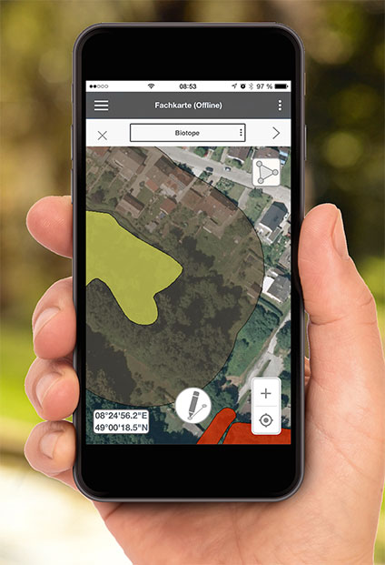
    Disy Informationssysteme GmbH, www.gis2go.com
    Photo: Gis2Go

    Global mobile wireless standards body 3GPP has given its approval to the regional navigation system created by the Indian Space Research Organization (ISRO), known as NaVIC, reports The Times of India.

    The approval was given for the system’s use in Rel-16 LTE and Rel-17 5G NR specifications, paving the way for wider commercial adoption of NaVIC and allowing it to be integrated with 4G, 5G and internet of things technology (IoT).

    Once these specifications are adopted by Telecommunications Standards Development Society, India (TSDSI), IoT devices in India can make a switch from GPS to NaVIC.

    Electronics companies can start designing and building integrated circuits and mass manufacture other products created to be compatible with NaVIC.

  • MBDA investigates GPS/GNSS-denied navigation under REASON project

    MBDA investigates GPS/GNSS-denied navigation under REASON project

    The REASON project uses satcom signals to help long-range missiles navigate. (Image: MBDA)
    The REASON project uses satcom signals to help long-range missiles navigate. (Image: MBDA)

    MBDA Missile Systems is exploring a navigation solution for long-range cruise missile systems that would use satellite communications signals to maintain precision navigation accuracies at range, reports Jane’s 360.

    MBDA told Jane’s that is has demonstrated for the first time a satcom-aided navigation as part of the Resilient and Autonomous Satcom Navigation (REASON) project. Also taking part in the project are Airbus Defence and Space and ONERA.

    REASON is part of the UK/French Materials and Components for Missiles Innovation and Technology Partnership (MCM IPT) programme, for which MBDA is the lead.

    REASON is evaluating the technical and system-level feasibility and benefits of using specialist satellite signals to aid navigation.

    For a medium-to-long duration flight, cruise missile systems require additional information to support inertial measurement unit (IMU) sensors to achieve the required level of guidance accuracy, Jane’s reported. Recent years have seen greater reliance on GPS/GNSS signals to provide navigation updates to correct IMU drift.

  • Polte and Altair embed location services on cellular IoT chipset

    Polte and Altair embed location services on cellular IoT chipset

    Altair Semiconductor integrates Polte’s Cloud Location over Cellular (C-LoC) technology with Altair’s ALT1250 dual-mode CAT-M& NB-IoT chipset.

    Photo: Altair
    Photo: Altair

    Polte Corp. and Altair Semiconductor have collaborated to integrate Polte’s cellular-based location technology with Altair’s ALT1250 cellular Internet of Things (IoT) chipset.

    The ALT1250 is Altair’s dual-mode CAT-M & NB-IoT solution, a small, highly integrated cellular IoT chipset with ultra-low power consumption, GNSS location positioning, a hardware-based security framework and an RF front-end supporting all commercial LTE bands.

    Enabling miniature module sizes of less than 100 square millimeters, the ALT1250 is suitable for a range of industrial and commercial IoT applications.

    Polte’s patented location-as-a-service (LaaS) solution leverages ubiquitous 4G and 5G cellular networks and cloud computing to enable highly accurate location data indoors and outdoors.

    Business processes, customer self-service automation, and better decision making insights enable consumer, commercial and industrial businesses to capitalize on location.

    “With the explosive demand for smaller and low powered IoT devices, Polte’s C-LoC technology is a great complement to the integrated GPS and GNSS capabilities of our dual-mode ALT1250 chipset,” said Oded Melamed, CEO of Altair Semiconductor.

    “Location is a key function in numerous IoT applications, such as smart meters, telematics and trackers, where low power and small form factor are crucial,” Melamed said. “We look forward to the opportunity of working with Polte to offer our customers the best solutions to meet their needs.”

    “Polte is poised to disrupt the location services market. As more and more IoT use cases demand indoor, outdoor and everywhere in between location, Polte’s software-only solution embedded on Altair’s dual mode ALT1250 chipset delivers location services — at lower cost, using less battery, more securely,” said Polte CEO Ed Chao. “We are excited about the opportunity to bring the power of Polte’s location services platform to Altair’s leading Cellular IoT chipset.”

  • Business presidents named for consolidated Raytheon businesses in Raytheon/United Technologies merger

    Business presidents named for consolidated Raytheon businesses in Raytheon/United Technologies merger

    logosRaytheon Company Chairman and CEO Thomas A. Kennedy announced leadership appointments for the Raytheon businesses that will be consolidated following the close of the merger of equals with United Technologies.

    Roy Azevedo will be president of the Intelligence, Space and Airborne Systems, which combines Space and Airborne Systems (SAS); Intelligence, Information and Services (IIS); and Forcepoint. The new business unit will have 2019 sales of approximately $15 billion.

    Wesley D. Kremer will be president of the Integrated Defense and Missile Systems, which combines Missile Systems (MS) and Integrated Defense Systems (IDS). The new business unit will have 2019 sales of approximately $16 billion.

    “Roy and Wes are defense industry veterans with proven track records developing and delivering advanced technologies,” said Thomas A. Kennedy. “Their global business acumen and strong customer focus will help ensure the new Raytheon Technologies Corporation is poised for success from day one.”

    Anthony “Toby” O’Brien was selected as chief financial officer for the new Raytheon Technologies Corp. O’Brien is the current CFO of Raytheon Company.

    The Raytheon business unit consolidation will be effective upon merger close, which is expected in the first half of 2020, subject to the satisfaction of customary closing conditions, including receipt of required regulatory approvals, as well as completion by United Technologies of the separation of its Otis and Carrier businesses.


    Roy Azevedo, President, Intelligence, Space and Airborne Systems

    Roy Azevedo was appointed president of Raytheon SAS in 2018. The business is a leader in the design, development and manufacture of integrated sensor and communication systems for advanced missions. These missions include intelligence, surveillance and reconnaissance; precision engagement; manned and unmanned aerial operations; electronic warfare; and space.

    With a workforce of 17,600 and 2018 sales of $6.7 billion, Space and Airborne Systems is headquartered in McKinney, Texas and operates across the United States and internationally, overseeing Raytheon UK.

    Before being named president of SAS, Azevedo was vice president and general manager of Raytheon’s Intelligence, Surveillance and Reconnaissance Systems, a mission area within SAS that focuses on electro-optical/infrared sensors, active electronically scanned array/scanning radars, and various special mission aircraft solutions to provide customers with actionable information for strike and persistent surveillance.

    The new Intelligence, Space and Airborne Systems business which Azevedo will lead, pairs his existing business unit with Raytheon’s Intelligence, Information and Services business, and the company’s commercial cybersecurity unit, Forcepoint™. The newly combined business will offer world-class airborne and space sensors, electronic warfare and communications systems, cybersecurity and cyber analytics capabilities, advanced air traffic control technologies, ground-based space logistics, training, and engineering services. It will also provide artificial intelligence and machine learning capabilities, and mission support.

    Azevedo, who joined Raytheon in 1989, also serves as a member of the Raytheon Saudi Arabia, Raytheon UK and Raytheon Australia Boards of Directors.


    Wesley D. Kremer, President, Integrated Defense and Missile Systems

    Wes Kremer currently serves as president of Raytheon Missile Systems, after being appointed to the role in March 2019. Missile Systems is the world’s leading producer of weapon systems for the United States military and the allied forces of more than 50 countries. It produces defensive and offensive weapons for air, land, sea and space, including interceptors for U.S. ballistic missile defense. The business continually develops and invests in new, innovative technologies such as hypersonic and counter-hypersonic weapons and directed energy systems to provide rapid, high-quality, affordable mission capability to its customers. It had 2018 sales of $8.3 billion and employs more than 16,000 people. Headquartered in Tucson, Arizona, Missile Systems also has locations in Alabama, Arkansas, Kentucky, New Mexico, Oklahoma and Texas, as well as oversight of Raytheon Emirates, where Kremer serves as board chair.

    Prior to leading MS, Kremer was president of Raytheon’s Integrated Defense Systems business, which is headquartered in Tewksbury, Massachusetts with 31 locations around the world and operational oversight of Raytheon Saudi Arabia. Its broad portfolio of weapons, sensors and integration systems supports its customer base across multiple mission areas, including air and missile defense systems; missile defense radars; early warning radars; naval ship radar systems; C5I® products and services; and other advanced technologies.

    Kremer also served 11 years in the U.S. Air Force as a weapon systems officer, flying the F-111 and F-15E, with more than 1,500 hours of flight time in fighter aircraft, including over 90 combat sorties. He joined Raytheon in 2003.


    Anthony “Toby” O’Brien, Chief Financial Officer

    Toby O’Brien was named chief financial officer for the future Raytheon Technologies Corporation on September 12, 2019. He currently serves as vice president and chief financial officer of Raytheon Company where he directs the company’s overall financial strategy. His responsibilities include financial reporting and controls, merger and acquisition activity, planning and analysis, investor relations, tax and treasury.

    Prior to his current position, O’Brien was vice president of finance and chief financial officer for Raytheon IDS. He has also served as Raytheon vice president of finance, CFO of Raytheon Aircraft Company and has held other senior finance positions across Raytheon.

    O’Brien joined Raytheon in 1986.

  • Apple warns old iPhones, iPads could hit GPS rollover problem

    Apple warns old iPhones, iPads could hit GPS rollover problem

    iPhone 4s. (Photo: Apple)
    iPhone 4s. (Photo: Apple)

    Anyone who owns an older model Apple iPhone or iPad could experience a device-breaking problem on Nov. 3, according to Apple.

    The issue could affect iPhone and iPad models introduced in 2012 and earlier.

    “If you don’t update to the newest version of iOS available for your device before November 3, some models might not be able to maintain an accurate GPS position. And functions that rely on the correct date and time—such as syncing with iCloud and fetching email—might not work,” Apple said in a blog post.

    The problem is because of the GPS time rollover on April 6. Affected Apple devices won’t be impacted until just before 12 a.m. UTC on Nov 3.

    The iOS update will solve the problem, enabling the device to maintain accurate GPS location and keep the correct date and time.

    Devices affected include iPhone 4s and 5, third and fourth-generation iPad, iPad mini and iPad 2. Learn specifics of affected models and how to update the operating system on the Apple website.

    If not updated, these devices might not be able to maintain accurate GPS position or perform functions that require accurate time, such as properly syncing with iCloud or fetching email. The devices also might not be able to receive over-the-air software updates. As a result, the only way to update the device will be to restore it via iTunes or Finder through a tethered connection.


  • Bentley Systems, Topcon launch Digital Construction Works venture

    Bentley Systems and Topcon Positioning Systems have announced their new, jointly owned company — Digital Construction Works  — is open for business.

    Bentley is a global provider of comprehensive software and digital twin cloud services for advancing the design, construction, and operations of infrastructure, and Topcon is a leader in positioning technology for the survey and construction industries.

    The companies made the announcement at The Year in Infrastructure Conference, held Oct. 21 in Singapore.

    Digital Construction Works has a global staff of digital construction experts and provides digital automation, integration and “twinning” services around a portfolio of fit-for-purpose software and cloud services from Topcon, Bentley, and other software vendors. The venture was created to realize the “breakthrough potential of constructioneering” for industrializing construction, according to a press release.

    Bentley Systems and Topcon joined forces in 2016 to jointly develop enhanced integration between their respective MAGNET and ProjectWise cloud services so that engineering and construction workflows could be integrated for improved project quality and performance.

    Since then, Bentley and Topcon have continuously introduced innovations in surveying, reality modeling, scheduling and logistics, work packaging, machine control, and progressive assurance for construction.

    In 2017, they opened Constructioneering Academies, including at Topcon’s “sandbox” facilities, for construction professionals to experience new digital best practices, first-hand. During 2018, the companies assimilated Bentley’s SYNCHRO and Topcon’s ClearEdge3D acquisitions into constructioneering offerings.

    Digital Construction Works is chartered to embed its experts within constructors’ major project teams to advance and optimize constructioneering processes for delivering better design-build outcomes.

    Through its digital integration services, to connect and automate constructors’ existing processes with constructioneering, Digital Construction Works can make the best projects better while also helping to institutionalize these digital workflows throughout a constructor’s full project portfolio, the companies said.

    At the same time, experiences gained by Digital Construction Works will help guide Bentley Systems and Topcon in prioritizing their constructioneering software development investments.

    Digital Construction Works is led by CEO Ted Lamboo, previously senior vice president of strategic partnerships for Bentley Systems, and COO Jason Hallett, formerly vice president of digital construction and business development for Topcon.

    Greg Bentley, CEO of Bentley Systems, said, “When we and Topcon recognized the opportunity for constructioneering to finally industrialize capital project delivery, we committed respectively to completing its software requirements. Indeed, our new software capabilities make possible construction digital twins—converging digital context, digital components, and digital chronology. What remains, in going digital for infrastructure construction, is for constructors’ people and processes to take advantage of the technology. We and Topcon have now in turn committed many of our best resources, professionals experienced in both construction and software, to serve shoulder-to-shoulder, in virtual hardhats, to innovatively advance the required digital integration. The Digital Construction Works joint venture has the full management and capital commitments of both our companies, multiplying its unique strengths for helping to realize constructioneering’s potential to close the world’s infrastructure gap.”

    Ray O’Connor, president and CEO of Topcon Positioning Systems, said, “What Topcon and Bentley Systems initiated in recent years was done in the spirit of changing mindsets and processes on how we approach construction, and that collaboration has led to the development of this joint venture. The creation of Digital Construction Works perfectly aligns with our focus of helping the industry succeed in meeting infrastructure demands through technological innovations. Through the new organization, companies will have the opportunity to integrate hardware and software capabilities to more quickly and efficiently adopt new technology for more rapid productivity improvements. With customized services to address the individual needs of an organization, widespread adoption and technology improvements can be more readily realized. We are excited to take this journey with Bentley Systems in moving the industry forward.”