Category: Applications

  • U-blox meter-level positioning technology offers enhanced GNSS for autos

    U-blox meter-level positioning technology offers enhanced GNSS for autos

    Photo: u-blox
    Photo: u-blox

    The ultra-robust M9 technology platform will suit demanding automotive and high-end telematics.

    U-blox, a global provider of positioning and wireless communication technologies, has launched its new ultra-robust meter-level M9 global positioning technology platform, designed for demanding automotive, telematics and UAV applications.

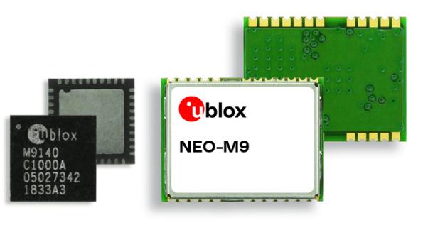
    Because of the high-performance GNSS UBX-M9140 chip, the M9 technology platform and the NEO-M9N (the first module based on the platform) can receive signals from up to four GNSS constellations (GPS, GLONASS, Beidou and Galileo) concurrently. It can achieve high positional accuracy even in difficult conditions such as deep urban canyons, u-blox said in a press release.

    The u-blox M9 offers a position update rate of up to 25 Hz, enabling dynamic applications like UAVs to receive position information with low latency. It also features special filtering against RF interference and jamming, spoofing detection and advanced detection algorithms that enable it to report fraudulent attacks quickly so that users’ systems can react to them in a timely fashion.

    A SAW (surface acoustic wave) filter combined with an LNA (low noise amplifier) in the RF path is integrated in the NEO-M9N module. This setup guarantees normal operations even under strong RF interferences, such as when a cellular modem is co-located with the NEO-M9N.

    “We’ve developed the u-blox M9 as a follow-on from our very successful u-blox M8 GNSS platform, offering even more robust meter-level positioning technology and security features to protect the integrity of applications in the automotive, telematics, and UAV markets,” said Bernd Heidtmann, product manager, Product Strategy GNSS, Product Center Positioning, at u-blox.

    Users of the u-blox M9 will benefit from it being part of the wider u-blox product family, which means that developers will be able to design a single PCB and then migrate to a different positioning technology — such as dead-reckoning augmenting GNSS technology — with little change to the board design.

    Explorer kit released

    U-blox has also released the Explorer Kit M9 (XPLR-M9), a development board for designers who want to assess the technology. The miniature plug-and-play device is supplied with user-friendly u-start software, which includes preset scenarios to enable users to explore the performance of the new device.

    The u-blox M9 technology platform complies with the ISO/TS 16949, ISO 16750, AEC-Q100 standards. Engineering samples of the NEO-M9N, the first module based on the M9 platform, the UBX-M9140 high-performance chip, and the Explorer Kit are available now.

    To learn more about M9, visit the u-blox booth, Hall South, S.2702, at Mobile World Congress 2019 in Los Angeles, Oct. 22-24.

  • Satelles completes funding round for secure PNT platform

    Satelles Inc., provider of highly secure satellite-based time and location services, has raised $26 million in Series C funding. C5 Capital led the round, with participation from Iridium Communications and existing investors.

    The new investment brings Satelles’s total funding since the launch of its platform to $39 million and will help the company expand its sales and marketing efforts, broaden its partner network, and accelerate product development.

    In 2016, Satelles demonstrated sub-microsecond timing using its Satellite Time & Location (STL) service with a stand-alone TCXO-based receiver. In February 2018, the company released new tests using configurations with a differential source and with a more accurate OCXO clock, producing timing accuracy of 160 nanoseconds.

    Industry and government requirements for positioning, navigation, and timing (PNT) are expanding at a rapid pace, and the Satellite Time and Location (STL) broadcast signal from Satelles provides assured PNT across a range of applications and at scale.

    “Today’s world runs on systems requiring trusted time and location information, and C5 Capital shares our commitment to make it a more secure and better place,” said Michael O’Connor, CEO of Satelles. “We are delighted that C5 led this latest investment round because they bring great insight into cybersecurity, and their international network is unparalleled.”

    Attacks such as jamming and spoofing — where a radio transmitter near the target is used to interfere with legitimate GPS or GNSS signals — and hacking are becoming more of a threat because of the key role that GPS and GNSS play in the operation of critical infrastructure.

    The STL signal strength is much greater than GNSS because the LEO satellites are much closer. (Slide: Satelles)
    The STL signal strength is much greater than GNSS because the LEO satellites are much closer. (Slide: Satelles)

    According to the company, the Satelles STL platform brings security to telecommunications networks, financial exchanges, electrical grids, maritime transportation systems, and many other sectors that depend on timing or location information.

    Downtime or malfunctions in these systems due to such attacks would be very costly. A June 2019 report sponsored by the National Institute of Standards and Technology estimated a $45 billion loss to the U.S. economy if GPS were to experience a 30-day service disruption.

    The Satellite Time and Location broadcast service from Satelles is encrypted to thwart malefactors aspiring to spoof or otherwise disrupt the STL signal, which is delivered via the low-Earth-orbit (LEO) satellite constellation operated by Iridium, an investor in this financing round.

    “STL addresses a critical and growing need across many applications and industries, so Iridium’s investment in Satelles aligns with our strategic vision,” said Matt Desch, CEO of Iridium Communications. “Satelles’s technology is unique and powerful, and we are proud to host such an innovative service that solves important problems and leverages the unique capabilities of our network.”

    The Iridium satellite constellation-based system offers many advantages:

    • A signal 1,000 times stronger than GPS/GNSS is better at reaching users and facilities in GPS/GNSS-challenged environments such as inside buildings, underground locations, and urban canyons.
    • Overlapping and constantly moving spot beams enable revolutionary cybersecurity solutions that can rely on trusted time and location for authentication and data access.
    • Polar-orbiting, cross-linked satellites ensure truly global coverage.
    • The L-band frequency range allows small, low-cost equipment to receive the Satelles STL signal.

    “The capabilities of Satellite Time and Location are enhanced by the technical and service delivery attributes of low-Earth-orbit satellites,” said Dr. Gregory Gutt, President and CTO of Satelles. “An extraordinary constellation such as Iridium’s gives us an incredible platform from which to deliver our trusted PNT solutions, so we remain committed to LEO technologies going forward.”

    Commenting on the closure of the Series C investment in Satelles, Andre Pienaar, Managing Partner of C5 Capital, said, “Space is a rapidly developing battleground for cyber threats to critical infrastructure, and GPS is unable to meet all these challenges. Satelles has developed a powerful solution which not only prevents attacks but provides a stronger and more effective service through STL. We are pleased to have led this funding round and look forward to working closely with this remarkable business.”

  • OriginGPS and Broadcom introduce L1 + L5 chip at MWC19 Los Angeles

    OriginGPS and Broadcom introduce L1 + L5 chip at MWC19 Los Angeles

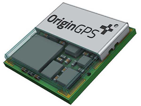
    OriginGPS has collaborated with Broadcom to create a new miniature module with L1 + L5 support provided by the BCM47758 chip, enabling ultra-accurate GNSS positioning. The module was developed for solutions requiring super-precision GNSS and a dual-frequency combination.

    Photo: OriginGPS
    Photo: OriginGPS

    The ORG4600-B01 is OriginGPS’ first dual-frequency GNSS module. The module enables customers to build solutions with sub-1-meter accuracy without implementing external components.

    Measuring 10 x 10 mm, the ORG4600-B01 module supports L1 + L5 GNSS reception with one RF port, enabling the use of a low-cost, dual-band antenna delivering sub-1-meter accuracy performance in real-world operating conditions.

    Alternate Build. An alternate build option allows for separate L1/L5 RF outputs when dual antennas are required. The ORG4600-B01 is suitable for solutions requiring ultra-accurate positioning, such as telematics, the Internet of Things (IoT) and auto OBD applications.

    When GPS World reported that dual-frequency chips were about to hit the mass market in December 2018, OriginGPS stated in a press release, it was clear that long-awaited dual-frequency infrastructure support had arrived. ABI Research predicted that dual-frequency chips would account for more than a billion chipset shipments in 2023.

    “This year has seen several satellites launched into orbit every month, most of them fitted with L5/E5 capabilities, and the Chinese and European Union governments plan to have their satellite constellations fully operational by 2020.” said Haim Goldberger, CEO of OriginGPS.

    Developing the ORG4600-B01 module with the BCM47758 GNSS receiver chip by Broadcom Inc. was the fastest and surest way to add a high-quality dual-frequency module to our portfolio and meet our customers’ increasing requirements for ultra-accurate GNSS modules,” Goldberger said.

    “Size is a crucial parameter in GNSS dual-frequency solutions,” said Prasan Pai, product marketing director for the Wireless Communications and Connectivity Division at Broadcom. “The collaboration with OriginGPS has created the industry’s smallest dual-frequency module with ‘no compromise’ quality. For our customers seeking an ultra-accurate GNSS solution in a compact form factor, the ORG4600-B01 fits the bill. The collaboration enables Broadcom to reach new markets, such as precision agriculture, security, children tracking and fleet management.”

    “OriginGPS is interested in additional partnerships to enable bringing advanced solutions to market quickly,” said Haim Goldberger, CEO of OriginGPS.

    OriginGPS is presenting its products with real-life demonstrations at MWC 2019, Los Angeles, Oct 22-24, Booth S2938.

  • Geotab and Ford launch integrated telematics solution

    Geotab, an IoT and connected transportation company, now offers the Geotab Integrated Solution for Ford Vehicles. Integrating Ford vehicle data into the MyGeotab platform gives fleet managers one dedicated portal with powerful tools to process data from vehicles with an embedded modem as well as those which require a third-party device.

    Through this integration, Ford Data Services will securely transfer data from Ford vehicles with a factory installed modem (or Ford Plug-In Modem, where required) to Geotab’s cloud environment, eliminating the need for third-party hardware in Ford vehicles.

    A business unit of Ford Smart Mobility, Ford Commercial Solutions help fleets improve their operational effectiveness by offering OEM-grade data verified by Ford engineers such as fuel use and vehicle health alerts. The Transportation Mobility Cloud (TMC), an open platform that securely manages information flow to and from Ford vehicles’ embedded modems, facilitates both new products.

    Simplifying the task of mixed-fleet management, the latest solution from Ford and Geotab provides fleet managers with the ability to oversee their entire fleet in one portal while also presenting the added benefit of access to the Geotab Marketplace, a portfolio of mobile apps, hardware add-ons and software add-ins that enable Geotab customers to further customize their fleet management solution.

    “Ford Data Services provides the ‘Power of Choice’ so that businesses can get manufacturer-grade vehicle information from the telematics provider of their choice, such as Geotab,” said Michelle Moody, director at Ford Commercial Solutions. “With the launch of Geotab Integrated Solution for Ford Vehicles, fleets are able to access vehicle information such as fuel usage, vehicle health and driver behavior, through the Geotab platform for vehicles with a Ford modem.”

    With the solution, fleet managers can access proprietary Ford-specific data available for all Ford 2020 or newer models in the United States.

    “The Geotab Integrated Solution for Ford Vehicles will allow fleet managers to benefit from the combination of Geotab’s actionable data insights and powerful rules engine with the rich diagnostic data from Ford’s factory-fitted modem,” said Geotab’s Sherry Calkins, Vice President, Strategic Partners. “This means that regardless of whether they are utilizing an embedded or externally installed telematics solution, the entire fleet can be managed from one platform.”

  • Spire Aviation launches AirSafe API for ADS-B tracking

    Spire Aviation launches AirSafe API for ADS-B tracking

    Image: Spire Aviation
    Image: Spire Aviation

    Spire Global has released the company’s first product from Spire Aviation with the launch of its new AirSafe API (application program interface).

    Spire Aviation’s AirSafe product uses low-Earth orbit ADS-B technology combined with ground-based collection to provide detail on global aircraft position reports for the world’s aircraft fleet operations.

    With more than 70 million position reports every day and growing, AirSafe is positioned to provide best-in-class data over land and the world’s oceans.

    The AirSafe product solves the industry’s need for flight tracking data covering both land and oceans at a competitive cost, illuminating trends in aircraft operations, the company said.

    Airsafe enables a fixed-based operator to analyze historical data to safely increase productivity by better positioning resources in the future, and then using real-time data to create a proactive alerting system for diversion or air turnbacks.

    Spire Aviation is building towards full surveillance of all remote areas of the globe and continues to grow its satellite constellation. Spire’s aggressive roadmap includes launch campaigns to ultimately provide an equatorial ICAO 4D/15 compliant method of aircraft tracking (+/- 15 degrees latitude) and global coverage enabled by inter-satellite links. These satellite launches will produce the an advanced nanosatellite constellation for aviation ADS-B and aviation weather forecasting.

    Spire AirSafe also offers Spire’s proprietary weather forecasting products, enabling customers to benefit from fused aircraft location positional data and global winds aloft (Every 1,000 feet MSL) and clear air turbulence forecast.

    Learn more about the benefits of working with Global ADS-B data and Spire’s Aviation Weather Forecast during an upcoming webinar.

  • Robinson helicopter converted for UAV precision farming

    Robinson helicopter converted for UAV precision farming

    UAVOS has added the R22-UV unmanned helicopter to its agriculture unmanned aircraft portfolio for spraying for diseases, weed and pest control, and vegetation control.

    The R22-UV is a manned Robinson-22 helicopter converted by UAVOS to an unmanned aircraft. (Photo: UAVOS)
    The R22-UV is a manned Robinson-22 helicopter converted by UAVOS to an unmanned aircraft. (Photo: UAVOS)

    The Agro-Drone R22-UV is equipped with a specially developed utility to deliver liquid chemicals — the spray system Simplex model 222.

    The R22-UV drone is provided with a 100-liter tank for chemicals and can stay airborne for two hours. Weight of the system is 42 kilograms, boom span is 7 meters, and swath width is 14 to 16 meters.

    UAVOS listed several advantages that could maximize the value of such a heavy UAV for farmers:

    • The R22-UV can be operated in the regions without airfields, under severe weather conditions and during night-time, in conditions with a high probability of risk for the pilot.
    • UAVs are excellent for operations in conditions of high humidity, where the use of ground equipment is impossible or difficult. Unlike heavy machinery, which cannot go into a field immediately after a heavy rain, UAV has no impact on the ground. Drone sprayers don’t touch the ground so there will be less soil compaction. This is when heavy machinery like tractors roll over the soil, pressing it down and damaging it. Farmers can fix this with plowing, but it can be harmful to the soil over a long period of time.
    • UAV implementation eliminates manual spraying with backpack sprayers, so workers don’t come into contact with hazardous chemicals.
    • UAVs also enable growers to spray their crops precisely and at will, which is critical for fighting herbicide-resistant weeds. Spraying is better. The rotor of an agricultural drone produces a huge downward rotation force, which promotes the pesticide droplets to penetrate the crop from top to bottom, which is conducive to the pesticide droplets evenly scattered in all parts of the plant, so that the spraying is accurate.
    • Unmanned aircraft can be used for spot spraying weeds with herbicides and are useful for spraying crops with pesticides. A spot-oriented approach based on preliminary analysis of digital images from robot cameras minimizes the cost of agrochemicals, reducing the chemical impact on soil, water, culture and, ultimately, on the consumer’s body, while achieving higher results of crop cultivation than with traditional approaches. The aircraft can be set on a predetermined GPS-defined route to fly over a field, dropping doses of pesticides, herbicides and fungicides as it flies.

    “Precision agriculture is based on the use of valuable metrics to make farmers’ crop management efficient and optimized,” said Aliaksei Stratsilatau, CEO of UAVOS. “Validating-of-damage reports used to be on paper. So, unmanned aircraft help our customers to validate the veracity of reports so that we could come up with a comprehensive solution. Generally, agriculture is very complex and there are a lot of problems, but there are solutions available through the new technology.”

  • MicaSense offers Altum 3-in-1 sensor for ag drone mapping

    MicaSense offers Altum 3-in-1 sensor for ag drone mapping

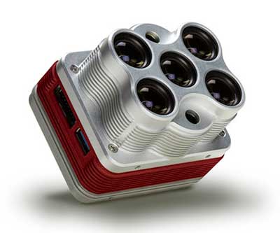
    The Altum is a 3-in-1 sensor that combines thermal, high-resolution and multispectral imaging capabilities in one sensor. (Photo: MicaSense)
    The Altum is a 3-in-1 sensor that combines thermal, high-resolution and multispectral imaging capabilities. (Photo: MicaSense)

    The Altum sensor, offered by MicaSense, is designed for professional-grade agricultural drone mapping by enterprise and academic researchers. The Altum captures synchronized multispectral and thermal imagery, enabling aligned outputs for advanced analytics.

    Altum’s multispectral imagers are the highest resolution integrated multispectral solution available for drones, allowing for detailed RGB outputs and advanced crop classifications.

    Whereas before they had to fly multiple flights with multiple sensors, researchers, growers and service providers can now capture data for plant health, water stress mapping, phenotyping and more in one flight, with one sensor.

    The Microsense RedEdge-MX sensor aboard DJI's M210 RTK drone. (Photo: MicaSense)
    The Microsense RedEdge-MX sensor aboard DJI’s M210 RTK drone. (Photo: MicaSense)

    “The Altum design resulted from experience developing advanced analytics and understanding needs for advanced research,” said Justin McAllister, CTO and co-founder of MicaSense. “We realized the market is limited by time and cost constraints of owning multiple sensors and flying multiple passes over the same field. The goal of Altum is to simplify the workflow, and with synchronized capture, to provide results that can be correlated and quantified more easily.”

    Altum includes MicaSense’s standard five-band configuration of multispectral bands (red, green, blue, near-infrared and red-edge) and an integrated Lepton radiometric thermal longwave infrared sensor from FLIR Systems, providing temperature measurement for every pixel of the scene for additional crop data and optimization.

    https://youtu.be/Kdim4uol7S4

    Expandable high-capacity USB 3.0 storage allows users to fly longer and cover more area without landing to swap storage. In addition, advancements in image capture rate enables faster flight speeds.

    Users can process Altum data with industry standard software like Agisoft and Pix4Dmapper to generate an aligned, radiometrically calibrated six band (R, G, B, RE, NIR, T) geotiff, or access the raw data from Altum to process data themselves.

    Included with Altum is DLS 2, the patent-pending next generation of the MicaSense Downwelling Light Sensor (DLS). DLS 2 allows for a more streamlined integration as it combines both the DLS and GPS into one product. In addition, through proprietary MicaSense technology, the DLS 2 will offer significantly better calibration for changing light conditions and better measurements over time.

    Integrated solutions

    Altum’s multiple interface options and open API gives users the ability to utilize Altum on a variety of platforms. In addition to the DJI SkyPort integration, Altum is integrated with drone offerings from the following companies (with more to come):

    • North America: Drone Nerds (U.S.), BirdsEyeView Aerobotics (U.S)., OmniView Tech (Canada), Sky Flight Robotics (U.S.), Blue Skies Drone Rental (U.S.)
    • Europe: 3D Target (IT), Globe Flight (DE), C-Astral (SI), Droneparts.de (DE), Ecobotix (DK), NaviGate (PL), Quantum Systems (DE)
    • Asia: Cybernetech (Japan), Shenzhen Qianhai Yaqi Technology (China)

    DJI Payload SDK Program: Altum and RedEdge-MX for DJI M200 Series

    Through DJI SkyPort, MicaSense is able to provide seamless integration of its specialized sensors with DJI’s powerful line of enterprise drones, resulting in the MicaSense Altum and RedEdge-MX solutions. This provides users a high-quality drone and sensor combination they can rely on to capture quality data every time – with virtually no set-up time.

    The DJI SkyPort integration for Altum and RedEdge-MX features plug-and-play integration for Altum and RedEdge-MX right out of the box, including power and quick connect/disconnect, and enhanced light calibration with MicaSense DLS 2.

    “Solutions like the MicaSense Altum and RedEdge-MX demonstrate the value of integrating specialized industrial payloads to DJI’s powerful drone platforms,” said Jan Gasparic, head of Enterprise Partnerships at DJI. “By collaborating with solution providers, we are expanding the benefits of drone technology to more and more industries. In the case of agriculture, a specialized suite of sensors and more advanced level of analytics can truly bring tangible value to business workflows and decision making today.”

    The Altum and SkyPort enabled RedEdge-MX and Altum are available today through the MicaSense website.

  • GSA releases 2019 GNSS Market Report

    GSA releases 2019 GNSS Market Report

    Image: GSA
    Image: GSA

    The new GSA GNSS Market Report is now available for download. The report provides a comprehensive overview of the GNSS market and the global industry, as well as a focus on EGNSS differentiators and synergies with Copernicus, according to the publisher, the European GNSS Agency (GSA).

    Areas covered include:

    • A general overview of the GNSS market and a global industry overview.
      Analysis of macro-trends affecting GNSS, including climate change and the circular economy, big data, artificial intelligence, the silver economy, cyber security and the sharing economy.
    • A review of the main GNSS market segments in detail, including trends and developments, forecasts for future shipments, revenues and the GNSS installed base, and a look into GNSS user requirements.

    GNSS in Space. This year, the report features the “Editor’s Special: GNSS for NewSpace,” a section that introduces GNSS receivers in satellites and their relation to the evolving space sector.

    GNSS market monitoring is a key activity of the GSA. Market monitoring supports GNSS stakeholders in their planning and decision-making, and offers a clear tool to understand GNSS trends and evolutions.

    Since its launch in 2010, the GSA GNSS Market Report has become the go-to-source for information on the dynamic, global GNSS market segments and applications.

  • Quectel achieves 5G data call over 5G mmWave module

    Quectel achieves 5G data call over 5G mmWave module

    Photo: Quectel
    Photo: Quectel

    Quectel Wireless Solutions has completed a data call over its 5G millimeter wave (mmWave) module that fully complies with 3GPP Release 15 5G NR standards.

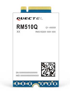
    The 5G data call on Sept. 25 was made over a Quectel RM510Q-GL 5G module based on Keysight’s 5G testing device in a lab, paving the way for the upcoming 5G mmWave field tests and commercial deployment of 5G internet of things (IoT) projects.

    In addition, the move is a testament to Quectel’s leadership in 5G research and development capability and IoT innovations.

    Tailored for IoT/eMBB (enhanced mobile broadband) applications, Quectel RM510Q-GL features the Snapdragon X55 5G modem and supports mmWave and sub-6 GHz frequencies in both 5G standalone (SA) and non-standalone (NSA) operations.

    The M.2 module covers nearly all the mainstream carriers worldwide. Designed backward compatible with LTE-A and 3G networks, RM510Q-GL integrates multi-constellation GNSS receiver, eSIM, as well as high-speed interfaces such as USB 3.1 and PCIe 3.0, which make it suitable for globally deployed mobile devices including Always Connected PCs (ACPC), industrial PDAs, mobile gateways and more.

    AsusTek Computer Inc., a Taipei-based multinational computer company, is planning to use RM510Q-GL for its next-generation 5G mmWave laptops, according to Quectel. Leveraging its industry leading 5G modules and local technical support, Quectel will accelerate the time-to-market for AsusTek to enhance its competitiveness in the 5G era.

    Quectel will showcase commercial 5G modules at the Qualcomm 5G Summit in Barcelona, Oct. 14-16, and MWC Los Angeles (Booth 1236), Oct. 22-24.

  • Army fields anti-jam GPS, plans for thousands more by 2028

    Army fields anti-jam GPS, plans for thousands more by 2028

    By Thomas Brading, Army News Service

    Sixty-two of the first iteration of mounted anti-jam GPS devices were equipped into light armored vehicles in Germany over the past month, with thousands more scheduled to be installed into U.S. European Command vehicles by 2028, said Army leaders in charge of location data on future battlefields.

    The Mounted Assured Precision Navigation & Timing System — known as MAPS — was developed to provide trusted positioning, navigation and timing (PNT) to a platform, such as Stryker vehicles, by pairing a GPS receiver with an anti-jam antenna, said Col. Nickolas Kioutas, PNT project manager.


    Read more about MAPS, along with other anti-jam systems, here. Also look for our anti-jam feature coming in the December issue of GPS World magazine.


    The electronic technology comes amid the Army’s vision for 2028, to best prepare soldiers for possible warfare with near-peer competitors, who have used electronic warfare to disrupt communications vital to Western forces in recent years.

    This year, more than 300 Stryker vehicles, all from the 2nd Cavalry Regiment, are expected to be fielded with MAPS technology, said Willie Nelson, the director of the Army’s Assured PNT Cross-Functional Team.

    Upgraded first-generation and second-generation technology is also expected to be unveiled in the future.

    The Army also plans to equip armored brigades with the technology, and put MAPS in vehicles such as the Bradley Fighting Vehicle, M1 Abrams tank, and the M109 Paladin self-propelled howitzer. After those “priority vehicles,” the Army will evaluate the mounted device in second-tier priority vehicles, Nelson said.

    Soldiers from 2-2 Stryker Brigade Combat Team move out in their Stryker during their training rotation at the National Training Center on Fort Irwin, Calif., Sept. 2, 2019. (Photo: Sgt. Ryan Barwick/U.S. Army)
    Soldiers from 2-2 Stryker Brigade Combat Team move out in their Stryker during their training rotation at the National Training Center on Fort Irwin, Calif., Sept. 2, 2019. (Photo: Sgt. Ryan Barwick/U.S. Army)

    In the past, armored vehicles have used multiple Defense Advanced GPS receivers, known as DAGR devices.

    MAPS replaces multiple DAGR devices with one “really good system,” said Kioutas. The new system uses a chip-scale atomic clock for timing, Selective Availability and Anti-Spoof Module, or SAASM, for GPS, and anti-jamming antenna to distribute PNT information.

    In addition, future iterations of MAPS will include non-GPS sensors by fusing GPS with alternate navigation and timing technologies to ensure accurate PNT that soldiers can trust while operating in various threat or denied environments, according to a statement.

    A single-point GPS also creates multiple practical benefits for soldiers, such as less maintenance and system key-failing, Kioutas said, adding many of his team’s decisions are based on Soldier feedback, because listening to them today helps prepare them for tomorrow.

    Simply put, “MAPS continues to work whenever a GPS signal is weakened or compromised,” he said.

    “This is the first technology equipping for the Assured Positioning, Navigation and Timing Cross-Functional Team, and one of the first for Army Futures Command,” Kioutas said.

    Nelson noted that they’re “working in parallel with both mounted vehicles and dismounted soldier’s PNT gear.”

    A soldier checks part of a Mounted Assured Precision Navigation & Timing System -- known as MAPS. Sixty-two of the first iteration of mounted anti-jam GPS devices were equipped into light armored vehicles in Germany over the past month, with thousands more scheduled to be installed into U.S. European Command vehicles by 2028. (Photo: John Higgins)
    A soldier checks part of a Mounted Assured Precision Navigation & Timing System — known as MAPS. Sixty-two of the first iteration of mounted anti-jam GPS devices were equipped into light armored vehicles in Germany over the past month, with thousands more scheduled to be installed into U.S. European Command vehicles by 2028. (Photo: John Higgins)

    Earlier this year, a requirements document for the dismounted soldier’s PNT was signed. Now, currently in the prototyping phase, the latest iteration of a dismounted GPS receiver can send secure PNT data wired or wirelessly, Kioutas said.

    “A lot is happening here, a lot of good success,” Nelson said, adding, the most important thing for his team is to get the best equipment to “warfighters on the front lines and getting their feedback rolled back into the next generation.”

    Nelson will host a Warrior’s Corner presentation Oct. 15 focusing on the PNT CFT’s Tactical Space Line of Effort, at the Walter E. Washington Convention center in Washington, D.C.

  • FAA’s ADS-B rebates are all gone — install by Jan. 1

    FAA’s ADS-B rebates are all gone — install by Jan. 1

    The United States Federal Aviation Administration (FAA) announced Oct. 11 that all 20,000 rebates offered to general aviation aircraft owners to equip their aircraft with Automatic Dependent Surveillance – Broadcast (ADS-B) Out have been issued and are no longer available.

    Aircraft owners who have already reserved their rebate, but not claimed it yet with installation, will be allotted the specified time needed to complete the requirements for the rebate.

    FAA ADS-B equippage deadline
    Image: FAA

    Starting Jan. 1, 2020, ADS-B Out avionics will be required for aircraft flying in certain controlled airspace. ADS-B is a state-of-the-art surveillance system that enables air traffic controllers to track aircraft with greater accuracy and reliability.

    The FAA first launched the $500 ADS-B rebate program in September 2016 to encourage owners of fixed-wing, single-engine piston aircraft to equip in advance of the Jan. 1, 2020 deadline and take advantage of ADS-B benefits.

    The FAA has reiterated that the deadline will not change.

  • Kinesis vehicle tracking aids logistics for European Tennis Open

    Kinesis vehicle tracking aids logistics for European Tennis Open

    Kinesis is equipping a fleet of luxury vehicles with advanced telematics for the 2019 European Open, held Oct. 13-20 in Antwerp, Belgium.

    The European Open has attracted top players including Gael Monfils who is ranked 12th in the world, Belgium player David Goffin and former Wimbledon champion Andy Murray.

    Fitted to vehicles supplied by Jaguar, Kinesis vehicle tracking will provide real-time visibility of vehicle movements for logistics, security and safety. Kinesis will fit the fleet with GPS devices that transmitting accurate and up-to-the-minute vehicle locations along with driver assessment data, giving 24/7 visibility of the tournament vehicles from any internet connected device.

    Photo: Kinesis
    Photo: Kinesis

    Kinesis is working with Tennium, a global tennis platform company that owns the ATP250 tournaments in Antwerp and Buenos Aires and represents a number of world-class players.

    The Jaguar Land Rover-supplied vehicles will include high-end cars, limousines and minibuses and will be used to collect players from the airport and transport them between official hotels and the Lotto Arena. The fleet will also be used to transport ATP officials, invited guests and VIPs.

    “Knowing where each vehicle is, where it is headed and at what time it is expected to arrive allows us to meticulously plan the transport of some of biggest names in tennis,” commented Karl Van Parys, logistics and transportation manager at Tennium. “With such high-profile sportsmen it is imperative that they arrive on court in good time and relaxed, and the Kinesis system will help us achieve this.”

    The Kinesis telematics intelligence will be used by organisers to plan journeys in accordance with a demanding tournament schedule. With visibility from desktops, tablets and mobile devices, the team can respond, in real time, to changing logistics requirements as play unfolds. Kinesis can also deliver driver performance data, including speeding, harsh braking and accelerating and idling, which can be used to improve driver behaviour for health and safety.

    “It is a real honour to be involved in such as prestigious event and work alongside some of the most well-known names in the world of tennis,” added Greville Coe, Group Managing Director of Kinesis. “The use of Kinesis telematics to inform decisions relating to tournament logistics as well as player safety and security, shows just how seriously the organisers take their responsibilities.”