Komatsu America Corp. has introduced Proactive Dozing Control logic, a fully-integrated dozing control system that allows operators to perform auto-stripping, auto-spreading, high production dozing and finish grading.
Built on the company’s intelligent machine control, the system uses GNSS positioning in conjunction with an inertial measurement unit (IMU) to calculate precise position. The two sensors work together to calculate exactly where the tracks are on the ground.
The machine control system communicates with the dozer’s hydraulic controllers, engine controllers and the machine controller. Through cylinder sensor technology, the position of the blade is calculated in relationship to the machine body.
The Proactive Dozing Control logic measures the surrounding ground and determines what has been done on the area being graded, then stores that data and information. When the dozer prepares to go back over that area to cut or work it more, the system understands what it was like from its previous track and, therefore, follows the existing terrain — the very terrain that was just created.
Proactive Dozing Control logic provides real-time position of the machine on the job site to create a highly accurate elevation for the system to drive the blade to the precise grade needed. Using real-time conditions, the system understands what the terrain around the machine looks like and makes calculated decisions — whether it should cut and carry material, whether it should spread or fill that material, or whether it should be finish grading.
The new system is available on the Komatsu D51EXi-24, D51PXi-24, D61EXi-24 and D61PXi-24 dozers.
Photo: Komatsu
“Proactive Dozing Control logic opens up a world of application possibilities for machine control technology,” said Derek Morris, Product Marketing Manager, Intelligent Machine Control and Smart Construction for Komatsu. “Traditionally, GPS machine control focused on finish grade, which meant operators only used the technology approximately 10 to 20% of the time. Proactive Dozing Control logic is a game-changer because the integrated system now lets operators use automation any time, whether for general site clean-up, backfilling trenches and more.”
“A key differentiator is that our system collects data at the tracks, while aftermarket solutions collect data at the blade,” Morris noted. “Because data is collected at the track, the system provides a real-time picture of the ground around the machine, allowing the system to make calculated decisions based on the current terrain. By collecting data at the track level, we’ve created machine control that is far more advanced, offering an entirely new level of efficiency, whether you’re an operator who has 20 years’ experience or someone new to the job, our Proactive Dozing Control logic provides precision work every time, making operation easier and more productive.”
With Komatsu’s Proactive Dozing Control logic, operators can use the dozer to its full capacity, leading to increased utilization, better ROI and better production. Owning and operating costs are also lowered because wear and tear on the machine is reduced by automating operation, Komatsu stated in a press release.
By significantly minimizing track slip during operation, undercarriage wear is reduced, thereby lowering O&O costs, since 50% of the ownership cost of a dozer is the undercarriage.
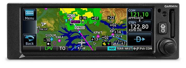
The GNC 355 is a GPS navigator with localizer performance with vertical (LPV) approach guidance and a built-in communications radio. (Photo: Garmin)
Garmin International Inc. has launched the GNC 355 — a GPS navigator with Localizer Performance with Vertical (LPV) approach guidance and built-in communications radio.
With the GNC 355, pilots can take advantage of the benefits of WAAS/SBAS GPS guidance, while also incorporating a modern comm radio into their existing avionics stack.
Intended for Class I/II aircraft that weigh 6,000 lbs./2,721 kg. or less, as well as experimental/amateur-built (EAB) aircraft, the GNC 355 Supplemental Type Certification (STC) is imminent and will be available in August for more than 700 aircraft makes/models.
“Based on the popularity of legacy products like the GX 60 and the GNC 250/300XL, as well as customer excitement for our new GPS 175 and GNX 375, we’re pleased to bring the GNC 355 to market,” said Carl Wolf, Garmin vice president of aviation sales and marketing. “The GNC 355 gives value-minded customers a simple upgrade path to a GPS navigator with a number of capabilities including WAAS/LPV approach guidance, wireless connectivity, a modern Comm radio, and with its standard mark-width form factor, pilots can easily add the GNC 355 without overhauling the panel of their aircraft.”
Aircraft owners can incorporate the GNC 355 into an existing avionics stack because of its standard 6.25-inch wide by 2-inch tall design. A vibrant, colorful and responsive touchscreen display boasts a familiar Garmin user experience, while a dual concentric knob and home button offer added versatility when interfacing with the touchscreen.
The user interface has been optimized for the screen size of the display, while also retaining a familiar menu structure similar to other Garmin products. Pilots can quickly access direct-to functionality, moving map, flight plan, nearest, procedures, waypoint and terrain pages, as well as frequency information using the touchscreen, and create customizable data fields and shortcuts for quick, one-touch access to important information.
Fully WAAS/SBAS IFR-approach-capable, the GNC 355 gives pilots the benefit of flying LPV, as well as Area Navigation (RNAV) approaches. Many approaches offer vertical approach guidance as low as 200-feet above ground level (AGL).
Pilots can also leverage the touchscreen and moving map to generate customized holding patterns over an existing fix in the navigation database or over a user-defined waypoint and easily insert it into a flight plan. Visual approaches are also available within the GNC 355 and provide lateral and vertical approach guidance in visual flight conditions.
Two versions, the GNC 355 and GNC 355A, are available with 25 kHz and 8.33 kHz frequency channel spacing respectively. Using the internal frequency database, airport, weather, Air Route Traffic Control Center (ARTCC) and Flight Service Station (FSS) frequencies are easy to find and can be loaded to the standby position by selecting the frequency from the airport information page. Recent, nearby and saved frequencies also offer easy access to frequency information. For example, with built-in standby frequency monitoring, pilots can listen to ATIS while monitoring tower frequency simultaneously. The airport identifier and frequency type are also displayed below the frequency so pilots can communicate with confidence.
An array of interface options includes the G3X Touch flight display for experimental and certificated aircraft, the G5 electronic flight instrument, the GFC 500 and GFC 600 autopilots, as well as select third-party autopilots. Course deviation and roll steering outputs can also be coupled to the GFC 500/GFC 600 autopilots and select third-party autopilots so procedures such as holds, radius-to-fix (RF) legs and missed approaches may be flown using the autopilot. Aircraft owners can also retain many of their existing flight instruments, audio panels and many legacy CDI/EHSI indicators such as the KI 208/209 products.
Additional interface options include pairing the GNC 355 with a dual-link Garmin Automatic Dependent Surveillance-Broadcast (ADS-B) solution, such as the GTX 345 or GDL 88. When paired with these products, the GNC 355 is capable of displaying subscription-free Flight Information Service-Broadcast (FIS-B) weather and ADS-B traffic targets, which includes patented TargetTrend and TerminalTraffic.
Wireless Connext devices running the Garmin Pilot and FltPlan Go applications. Pilots can also use the Flight Stream 510 to access the wireless benefits of Garmin’s Database Concierge, which uploads aviation database information from the Garmin Pilot app to the GNC 355 in minutes.
The GNC 355 provides a number of additional benefits, including graphical flight plan editing, allowing pilots to more easily edit their flight plan based on an ATC amendment or weather. Features such as FastFind simplify flight plan entry by applying predictive logic to suggest airports and waypoints using current GPS location, while Smart Airspace makes it easier to identify pertinent airspace on the moving map.
The addition of SafeTaxi airport diagrams displays runways, taxiways, Fixed Based Operators (FBOs), hangars and more relative to the aircraft’s location on the airport surface.
The GNC 355 and GNC 355A can be purchased through the Garmin Authorized Dealer network at that time starting at a list price of $6,9951 and $7,6951 respectively.
European Union Aviation Safety Agency (EASA) validation is expected at a later date.
A free GNC 355 trainer app is also available for download on Apple mobile devices, which allows customers to explore the feature set.
A new night map integration feature is available for all Concept3D maps. The toggle-on map overlay is designed to enhance campus safety and security by making it easy to find the best, well-lit routes and critical resources such as emergency phones.
The Concept3D interactive mapping platform is used by hundreds of major universities, colleges and schools, as well as convention centers, hospitals, resorts, retirement communities, data centers and businesses.
The night map feature offers all of these clients a way to provide their audiences with important safety and security information for visiting and navigating the campus at night.
The University of Denver, Boise State University, and Pacific Lutheran University are the first to integrate this feature into their Concept3D-powered interactive campus maps.
The night map of the campus of Boise State University. (Image: Concept3D)
Boise State University is using the new night map feature to highlight Public Safety Dispatch Centers, Emergency Blue Light and Refugee Phones and locations of automated external defibrillators (AEDs). Each item has a display box that further explain the exact location of the service and additional information.
Pacific Lutheran uses the night map to display campus AEDs, emergency telephones, and its safety building.
Colleges and universities that participate in federal Title IV student financial assistance programs must comply with the Clery Act, which requires annual security reporting, details and geographic information about crimes committed on campus and on public areas immediately adjacent to the campus, and timely warnings and emergency notifications, among other requirements.
New technology makes GPS more secure and reliable for military systems.
Raytheon has received security certification for new GPS modules and receivers from the GPS Directorate at the U.S. Air Force Space and Missile Systems Center.
The new modules and receivers will give military aircraft, ships, ground vehicles and weapon systems secure and reliable access to modernized GPS.
“Because GPS is under constant attack, we worked with our government partners to create new M-code modules and receivers that give the military secure and resilient navigation systems,” said Eric Ditmars, vice president of Raytheon’s Secure Sensor Solutions. “And since the tech is platform agnostic, it will work on a wide-range of platforms in the air, on the ground or at sea.”
Raytheon’s military code common GPS module was certified, along with its ground-based GPS receiver, or GB-GRAM, and the avionics GPS receiver, or GRAM-S/M. GB-GRAM and GRAM S/M are jointly developed with Trimble, while General Dynamics provides cryptographic capabilities for the modules.
“Operators need a system that is flexible and fast,” said Chad Pillsbury, director of Resilient Navigation at Raytheon Space and Airborne Systems. “We’ve designed these GPS systems with a common security architecture — meaning we can get this capability in the hands of operators faster and eliminate the need for additional security certifications.”
Ships sailing through the Strait of Hormuz and the Persian Gulf have been experiencing GPS interference that U.S. officials suspect is the work of the Iranians, according to CNN.
The U.S. Department of Transportation’s Maritime Administration issued an advisory on Aug. 7 to ships traveling in the Persian Gulf, Strait of Hormuz, Gulf of Oman, Arabian Sea and Red Sea. Ships have reported GPS interference, bridge-to-bridge communications spoofing and jamming, and other problems.
Iran’s goal is for ships and aircraft to wander into Iranian waters or airspace, justifying a seizure, a U.S. defense official told CNN. He said Iran has placed GPS jammers on Iran-controlled Abu Musa Island, which lies in the Persian Gulf close to the entrance of the Strait of Hormuz.
“Heightened military activity and increased political tensions in this region continue to pose serious threats to commercial vessels,” reads the advisory. “Associated with these threats is a potential for miscalculation or misidentification that could lead to aggressive actions. Vessels operating in the Persian Gulf, Strait of Hormuz, and Gulf of Oman may also encounter GPS interference, bridge-to-bridge communications spoofing, and/or other communications jamming with little to no warning.”
In at least two incidents, vessels reported GPS interference. One vessel reportedly shut off its Automatic Identification System (AIS) before it was seized, complicating response efforts.
Vessels have also reported spoofed bridge-to-bridge communications from unknown entities falsely claiming to be U.S. or coalition warships.
Since May 2019, the following maritime incidents have occurred in this region:
Six attacks against commercial vessels.
Shoot-down of U.S. Navy remotely piloted aircraft over international waters
Attempted at-sea interdiction of Isle of Man-flagged M/V British Heritage (oil tanker)
Seizure of ex-Panama-flagged M/V Riah (oil tanker)
Seizure of U.K.-flagged M/V Stena Impero (oil/chemical tanker)
Detention and subsequent release of Liberian-flagged M/V Mesdar (oil tanker).
MicroSurvey Software, part of Hexagon, has released its new field data-collection software platform for Android users.
FieldGenius for Android, version 1.0, is first release of the company’s new multi-platform field software built on the Android platform. It supports most popular GNSS sensors on the market today.
FieldGenius is third-party, brand-neutral data-collection software used by many surveyors. The new release builds on decades of innovation MicroSurvey has invested into the original FieldGenius software, providing users with an easy-to-use and intuitive mobile data-collection software package for the next generation.
New features include dynamic data panels synchronized with the map views. A fresh user interface provides familiarity for existing FieldGenius users while offering new tools, simplified workflows and readily available data that surveyors require at the point of work to make informed decisions in the field.
“Surveyors, dealers, and distributors from every corner of the world have been demanding an Android based version of MicroSurvey FieldGenius for years,” said Marc Veinotte, global sales and OEM manager at MicroSurvey. “This is the first release of our new multi-platform field data collection software that will provide a consistent user experience across a wide cross section of data collection devices. MicroSurvey continues its hardware neutrality strategy offering support for almost every brand of popular and upcoming GNSS receiver on the market today.”
Early adopters of FieldGenius for Android will receive additional benefits and participate in the newly created MicroSurvey Technology Innovation Group (MTIG).
The National Geodetic Survey (NGS) is now developing the 2022 transformation model. Once again, NGS requests the assistance of the surveying and mapping community. This column provides examples to explain the symbology and use of the new version of the GPS on Bench Marks program for developing the 2022 transformation tool.
My last column discussed the results of the Beta hybrid Geoid18 model, and the differences between the Beta model and the official hybrid geoid model, Geoid12B. It provided examples to explain the symbology of the Beta Geoid18 Web Map. It was noted that NGS analysts rejected stations based on pre- and post-modeled residuals but many times there wasn’t enough redundant information available to ensure the station should be rejected or used in the creation of the hybrid geoid model. As I have mentioned before, users should be commended for their participation in the GPS on Bench Marks program. The Geoid18 model is still in “Beta” so, hopefully, users will continue their support by evaluating the Beta hybrid geoid model and reporting their issues to NGS. Saying that, NGS’ GPS on Bench Marks program is now in a different phase.
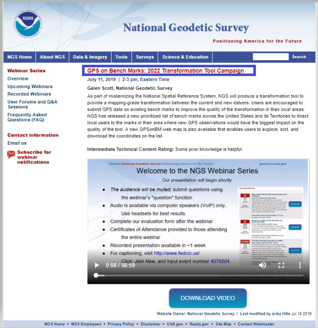
NGS held a webinar in July on the latest GPS on Bench Marks program for developing the 2022 Transformation tool. The webinar was recorded and users can find the presentation here. This was an excellent webinar and explained the functions of the web map. I would encourage readers to watch the webinar. It is an hour long but is worth while watching. See Figure 1 for information on the webinar.
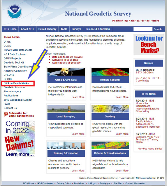
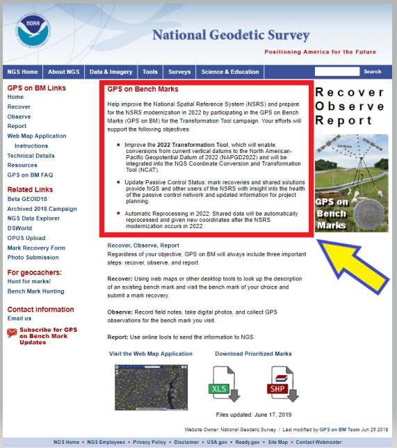
As in the past, the NGS on Bench Marks program can be accessed from NGS’ web page (see Figure 2). The user clicks on the “GPS on Bench Marks” button to access the program’s web page.
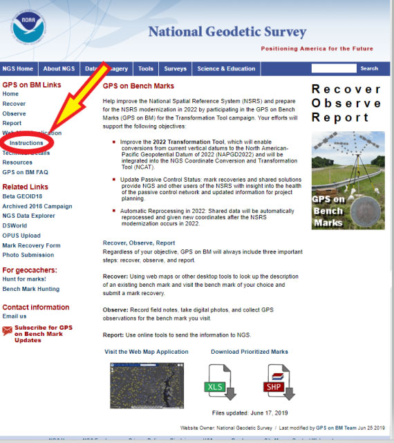
Figure 3: GPS on Bench Marks Home Web Page (Photo: National Geodetic Survey)
The web page provides several reasons why users should continue to participate in the GPS on Bench Marks program. Figure 4 lists three reasons for helping NGS develop the 2022 Transformation Tool.
Help improve the National Spatial Reference System (NSRS) and prepare for the NSRS modernization in 2022 by participating in the GPS on Bench Marks (GPS on BM) for the Transformation Tool campaign. Your efforts will support the following objectives:
• Improve the 2022 Transformation Tool, >which will enable conversions from current vertical datums to the North American-Pacific Geopotential Datum of 2022 (NAPGD2022) and will be integrated into the NGS Coordinate Conversion and Transformation Tool (NCAT).
• Update Passive Control Status: mark recoveries and shared solutions provide NGS and other users of the NSRS with insight into the health of the passive control network and updated information for project planning.
• Automatic Reprocessing in 2022: Shared data will be automatically reprocessed and given new coordinates after the NSRS modernization occurs in 2022.
I’d like to highlight a few of the benefits for participating in the GPS on Bench Marks program.
(1) Improve the 2022 Transformation Tool, which will enable conversions from current vertical datums to the North American-Pacific Geopotential Datum of 2022 (NAPGD2022) and will be integrated into the NGS Coordinate Conversion and Transformation Tool (NCAT).
> A goal of the transformation tool is to provide a model that will allow users to convert from the current North American Vertical Datum of 1988 (NAVD 88) to the new North American – Pacific Geopotential Datum of 2022 (NAPGD2022). The more bench marks that are occupied by GNSS and included in OPUS Shared solutions will enable NGS to generate a more detailed relationship between NAVD 88 and NAPGD2022. This will provide an accurate transformation tool in local areas which will facilitate the implementation of NAPGD2022 in surveying and mapping products and services.
(2) Update Passive Control Status: mark recoveries and shared solutions provide NGS and other users of the NSRS with insight into the health of the passive control network and updated information for project planning.
> An important part of the GPS on Bench Marks program is that it provides an indication of the status of the station. The last time a bench mark was leveled to varies greatly across the Nation. Many of stations in NGS’ Integrated Dataset haven’t been visited in over 50 years. The GPS on Bench Mark program can be useful to identify stations that have moved since the last time it was part of a leveling project. The mark recoveries will provide the latest status of a station which will help others in future project planning. More important, in my opinion, is that the OPUS shared solutions will identify stations that no longer have valid NAVD 88 published heights, and should be used with caution and flagged with a warning
(3) Automatic Reprocessing in 2022: Shared data will be automatically reprocessed and given new coordinates after the NSRS modernization occurs in 2022.
>> Any station that is part of the GPS on Bench Marks program and included in the OPUS Shared solution database will be given 2022 coordinates. This means that users will not have to resubmit their data to obtain the new coordinates in the new 2022 reference frames. This information will be useful during the implementation phase of the 2022 reference frames.
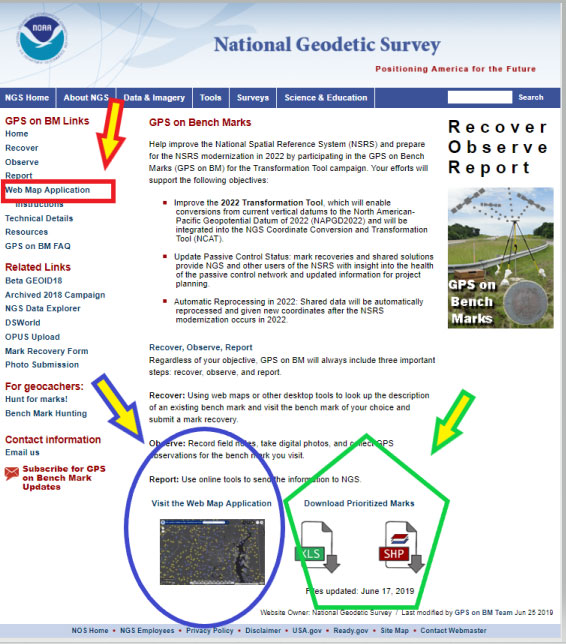
As in the past, NGS is developing web-based products and services to facilitate users incorporating their data into the National Spatial Reference System (NSRS). They have developed a GPS on Bench Marks Web Map Application to inform users which stations they would like occupied by GNSS equipment. They realize that everyone is busy so they are trying to provide information, in near real time, on stations that have been occupied to reduce users occupying a station that already has two occupations. Figure 5 depicts the buttons that will connect the user to an interactive web map application. There are several ways the user can access the application: (1) click on the link titled “Web Map Application” – the red rectangle and arrow in the box titled “GPS on Bench Marks Web Map Application Site,” (2) click on the figure of the web based application – see the blue ellipse and blue arrow in the box, and (3) download the prioritized marks in XLS or Shape file format – see the green pentagon and green arrow in the box.
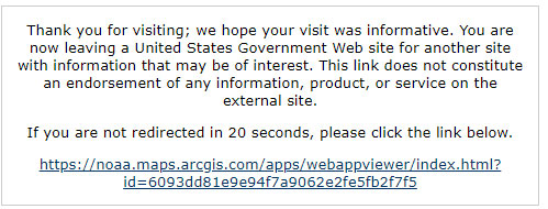
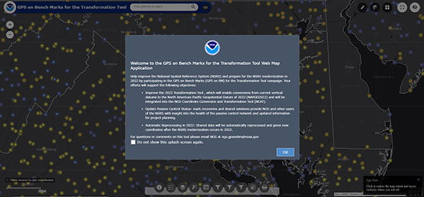
Clicking on the Web Map Application button or picture will direct the user to a new website. It informs the user that they are leaving a U.S. Government Web Site for another site. See Figure 6. The user can either click on the statement or just wait until they are redirected the website. (See Figure 7.)
Figure 6: Clicking on the Web Map Application Button or Picture (Photo: National Geodetic Survey)Figure 7: GPS on Bench Marks For the Transformation Tool Interactive Web Map (Photo: National Geodetic Survey)
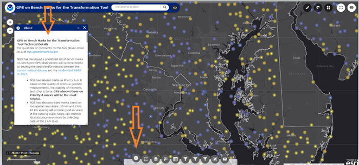
Just click on the “OK” button to remove the splash screen. You can click the button “Do not show this splash screen again” so it doesn’t show up every time you access the web page. At the bottom of the web map is a legend that provides information about the map and allows the user to select various options. Figure 8 provides an example of legend buttons. The information box appears by clicking on a particular icon in the legend bar (the arrows indicate the icon and information box for that icon).
Figure 8: Legend on GPS on Bench Marks Web Map Application Site (Photo: National Geodetic Survey)
There’s a lot of information provided in the information box. There’s a scroll bar on the right side of the box that provides the entire write up. Figure 9 provides several sections of the write up. I’ve highlighted sections in the write up to emphasis what NGS is trying to accomplish. NGS’ goal is to minimize the amount of work performed by users and maximize the amount of GNSS data provided to the development of the 2022 transformation tool.
First, NGS has prioritized marks at two spatial resolutions: 10 km and 2 km. They want to reach a 10 km density to provide good national accuracy and a 2 km level to improve local accuracy. The Interactive Web Map allows users to zoom down to a level to identify individual stations selected by NGS. A 10-kilometer hexagonal lattice was developed to define the desired data density on the ground. For each hexagon, the goal was to identify a primary mark and a list of up to 4 secondary marks. The primary mark for each hexagon was added to the priority mark list. Secondary marks are listed and should be observed in cases where the primary mark cannot be found or is unobservable.
To reduce duplication, when a single mark within a 10 km hexagon has two GPS observations that meet NGS requirements, that hexagon is marked as done and the station is removed from the prioritized list. This will help to reduce the number of surveyors occupying the same station over and over again, and increase the number of prioritized stations occupied with GNSS. After a 10-kilometer hexagon is marked as done, a group of up to thirteen 2 km hexagons is generated to define the opportunities to densify the model with additional marks.
To assist in the selection of stations to be part of the GPS on Bench Marks program, NGS has prioritized stations as Priority A and B. Priority A being more important than priority B for the development of the 2022 transformation tool.
Figure 9: Excerpts from GPS on Bench Marks for the Transformation Tool Technical Details
For questions or comments on this tool please email NGS at [email protected].
NGS has developed a prioritized list of bench marks on which new GPS observations will be most helpful to develop the best transformations between the current vertical datums and the modernized NSRS in 2022.
• NGS has labeled marks as Priority A or B based on the quality of previous geodetic measurements, the stability of the mark, and other criteria. GPS observations on Priority A marks will be the most helpful.
• NGS has also prioritized marks based on two spatial resolutions: 10 km and 2 km. 10 km spacing will provide good accuracy at the national scale. Users can improve local accuracy even more by collecting data at the 2 km level.
• NGS will build the transformation tool with data submitted by December 31, 2021. The tool will interpolate over areas without GPSonBM data, meaning that the transformations will be less accurate in those areas.
Priorities A and B
Priority A
Priority A marks meet the following specific criteria from their datasheets and are most likely to be used to create the transformation tools:
• Vertical Order: FIRST, SECOND
• Stability: A, B, C
• Satellite: USEABLE
• Last Recovery Condition: excluding “MARK NOT FOUND”
Priority B
Priority B marks are lower quality marks that will only be considered for use in the transformation tool to fill data gaps if no other data exists in the region.
Spatial Resolution NGS has also prioritized marks at two spatial resolutions: 10 km and 2 km. NGS wants to reach a 10 km density to provide good national accuracy. Additionally, users can help improve local accuracy by collecting data at the 2 km level.
To prioritize marks based on the two spatial resolutions, NGS created the following system:
• A 10-kilometer hexagonal lattice was developed to define the desired data density on the ground and help select appropriate marks within those areas throughout the U.S. and territories.
• Hexagons with appropriate bench marks were identified.
• For each hexagon, a primary mark was selected and a list of up to 4 secondary marks — if available — were identified. The primary mark for each hexagon was added to the priority mark list. Secondary marks are listed and should be observed in cases where the primary mark cannot be found or is unobservable.
To communicate when observations in a hexagon have been completed, the following process was developed:
• Once a single mark within a 10 km hexagon has two GPS observations that meet the requirements, that hexagon is marked as done and the observed mark is removed from the prioritized list.
• Once a 10 km hexagon is marked as done, a group of up to thirteen 2 km hexagons is generated to define the opportunities to densify the model with additional marks.
• In each of the 2 km hexagons, a primary mark is identified and a list of secondary marks is provided in case the primary mark cannot be found or is not observable. The new primary marks are added to the priority mark list. The number of 2 km hexagons will vary since not all areas have bench marks inside the 2 km lattice. See graphic below:
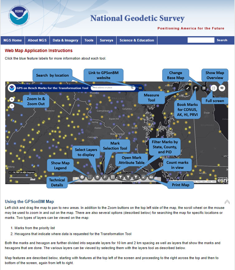
Clicking on the Web Map Applications “Instructions” button will provide a summary of all of the tools available on the Web Map. See the arrow in Figure 10. The instruction page provides a lot of information and explains the function of each tool.
Figure 11 provides an excerpt from that web page. All of the icons on the Web Map are explained on a mock up of a sample map in the beginning of the Instruction web page.
The list of detailed descriptions of the tool is fairly long so I’ve provided some of the descriptions in Figure 12. The reader is referred to this page for the descriptions of all of the tools.
Legend
Clicking this button will display the legend for all of the active layers displayed on the map.
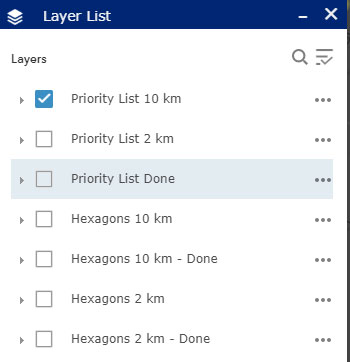
Layer List
Clicking this button will bring up the list of available layers to display on the map. By default, only the Priority List of marks at 10 km spacing appears. Users can select other layers to display on the map by clicking on the box to the left of the layer name. Once clicked, the box will show a check mark, and all layers with check marks are displayed on the map.
Layer Descriptions:
• Priority List 10 km – Marks requested for national coverage
• Priority List 2 km – Marks requested to densify local areas
• Priority List Done – All marks with enough observations to be considered for use in the Transformation Tool.
• Hexagons 10 km – Areas where GPSonBM data is still requested to complete broad national coverage
• Hexagons 10 km – Done – Areas where sufficient data exists
• Hexagons 2 km -Areas where GPSonBM data may still be submitted to increase local accuracy of the transformation tool.
• Hexagons 2 km – Done – Areas where sufficient data exists.
Image: National Geodetic Survey
Working with the Layer List
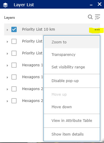
Clicking on the ellipsis to the right of each layer opens a window with actions for that layer. Set visibility range allows the user to set the zoom level at which each layer appears. By default the visibility ranges are set to prevent too much data from being plotted at once which would slow down the application. Users with fast internet connections can change the visibility range to allow data to be displayed when zoomed out far enough to see the extents of larger states.
Image: National Geodetic Survey
Mark Selection Tool:
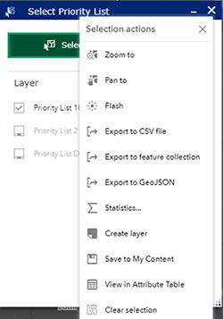
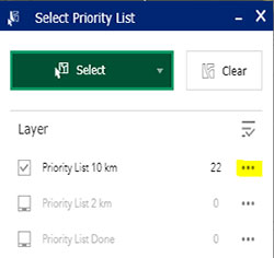
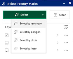
This tool provides several options for selecting marks. First, change the layer to select from, click in the box to the left of the layer name. Click the green Select box and choose a selection method, then use the mouse to left-click on the map to draw the selection region. Selected marks’ icons will turn blue. Once marks are selected, click on the ellipsis to the right of the layer to open menu of actions that can be performed with selected marks. Using this menu, selected marks can be exported into csv, JSON, and GeoJSON formats.
Image: National Geodetic Survey
Attribute Table
This button opens a table at the bottom of the screen that displays all the information available on each mark.
Image: National Geodetic SurveyImage: National Geodetic Survey
Filters
By State, County, and PID: This tool allows the user to filter the marks on the map down to specific states, counties, or PIDS. After selecting the filter option, click on the switch at the top right of the filter box and the map will pan and zoom to the selected area. If the marks do not appear on the map, try zooming in until they appear.
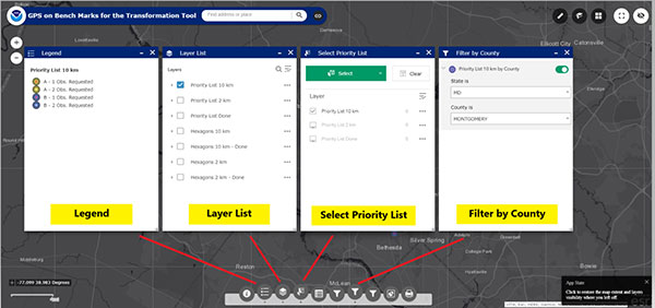
Figure 13 provides four different options of the icons on the bottom of the web map. They include the “Legend,” Layer List,” Select Priority List,” and Filter by State. These options help the user focus on a particular area of interest. I would encourage the user to familiar themselves with each of these options because they help will make it easier to navigate the map and identify priority stations.
Figure 13: Example of Several Options on the Legend on GPS on Bench Marks Web Map Application Site. Examples below are for the “Legend,” Layer List,” Select Priority List,” and Filter by County.” (Photo: National Geodetic Survey)
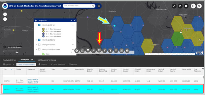
Another important icon located at the bottom of the Web Map opens an attribute table of the bench marks. (See Figure 14). Once you open the Attribute table tool (see the red arrow in the box), a table of attributes of the stations appears at the bottom of the screen. If you click on a station in the table, the station gets highlighted on the map (see the blue arrow in the box). NGS’ Web Map Application makes it very easy to locate potential stations in a user’s area of interest.
Figure 14: Example of the Attribute Table on the Legend on GPS on Bench Marks Web Map Application Site (Photo: National Geodetic Survey)
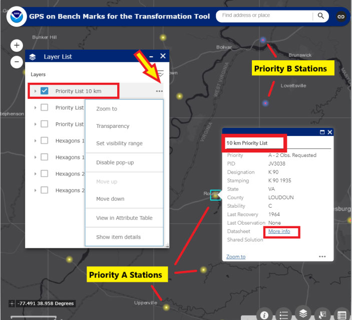
When the user clicks on the Layer List tool, they can select which priority list they would like to see plotted on the map. They can click on the “More Info” button to obtain the latest NGS Datasheet. Figure 15 provides an example of A and B stations from the 10 km priority list in the Loudoun County, Virginia, region. The map highlights priority A and B stations; the user can than find more information about a specific station by clicking on the map.
Figure 15: Excerpt from GPS on Bench Marks Web Map Layer List – Priority List 10 km (Photo: National Geodetic Survey)
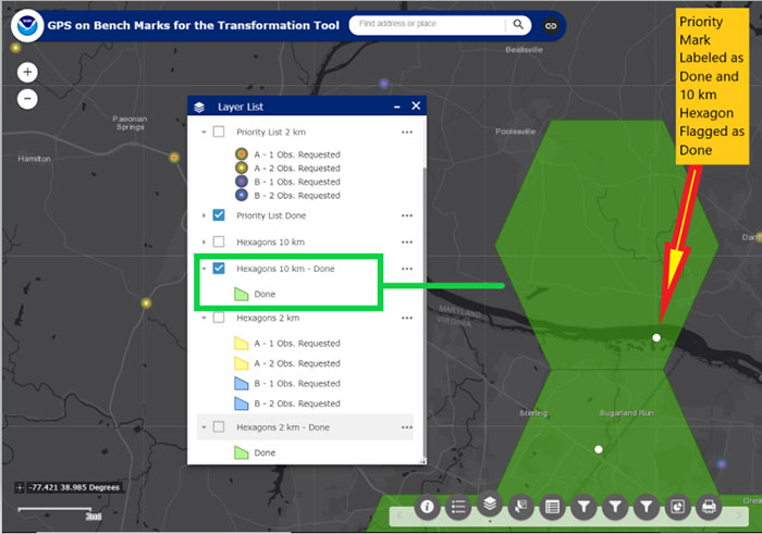
A very interesting feature is that once a station is classified as done in a 10 km hexagon, the hexagon is colored green and flagged as done. There is no longer a requirement to occupy a station in that hexagon to assist the 2022 transformation tool for the National level of accuracy. See Figure 16 to see a 10-km hexagon labeled as “Done.” Note that the station considered “Done” is labeled with a white circle.
Figure 16: An Example of a 10-km Hexagon in the Montgomery County, Maryland, and Loudoun County, Virginia, Region (Photo: National Geodetic Survey)
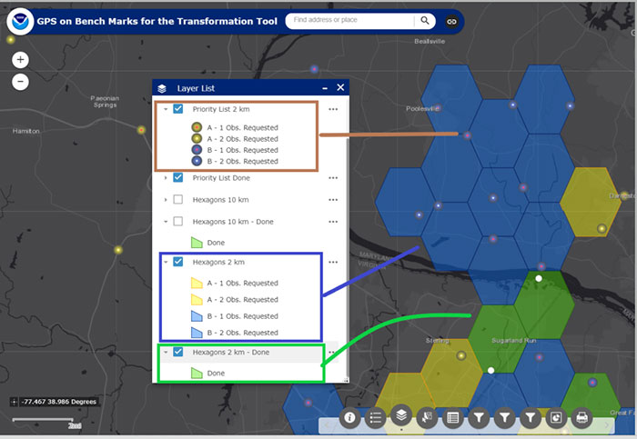
Now the user can focus on the 2-km hexagon boxes to identify stations to improve the local accuracy of the 2022 transformation tool in their area of interest. Figure 17 provides an example of the 2-km hexagons with priority marks plotted within each 2-km hexagon. Once again, the symbology indicates A and B stations, and the 2-km hexagons that need more observations and the hexagons that are labeled as “Done.”
Figure 17: An Example of 2-km Hexagons in the Montgomery County, Maryland, and Loudoun County, Virginia, Region (Photo: National Geodetic Survey)
NGS’ goal is to update the Interactive Web Map in “Near Real Time.” Of course, there’s always going to be some lag time from the time the user uploads their data into the OPUS Shared solution database to when the NGS 2022 Transformation Team reviews the data to ensure the results meet NGS’ criteria. Once again, NGS wants to minimize the amount of duplicate work performed by surveyors and maximize the number of stations contributing to the development of the 2022 transformation tool.
This newsletter highlighted the next phase of NGS’ GPS on Bench Marks program; that is, the development of the 2022 transformation model. The newsletter provided examples to explain the symbology and use of the new version of the GPS on Bench Marks program. It provided web links to material explaining the new GPS on Bench Marks program such as NGS’ July 2019 webinar on the latest GPS on Bench Marks program for developing the 2022 Transformation tool. NGS has done a tremendous job of explaining the importance, process, and results of the GPS on Bench Marks Program. Several of my previous newsletters have highlighted the NGS GPS on Bench Marks program and how users have supported the development of the hybrid Geoid18 model: Hopefully, this support will continue to develop the best possible 2022 Transformation Tool.
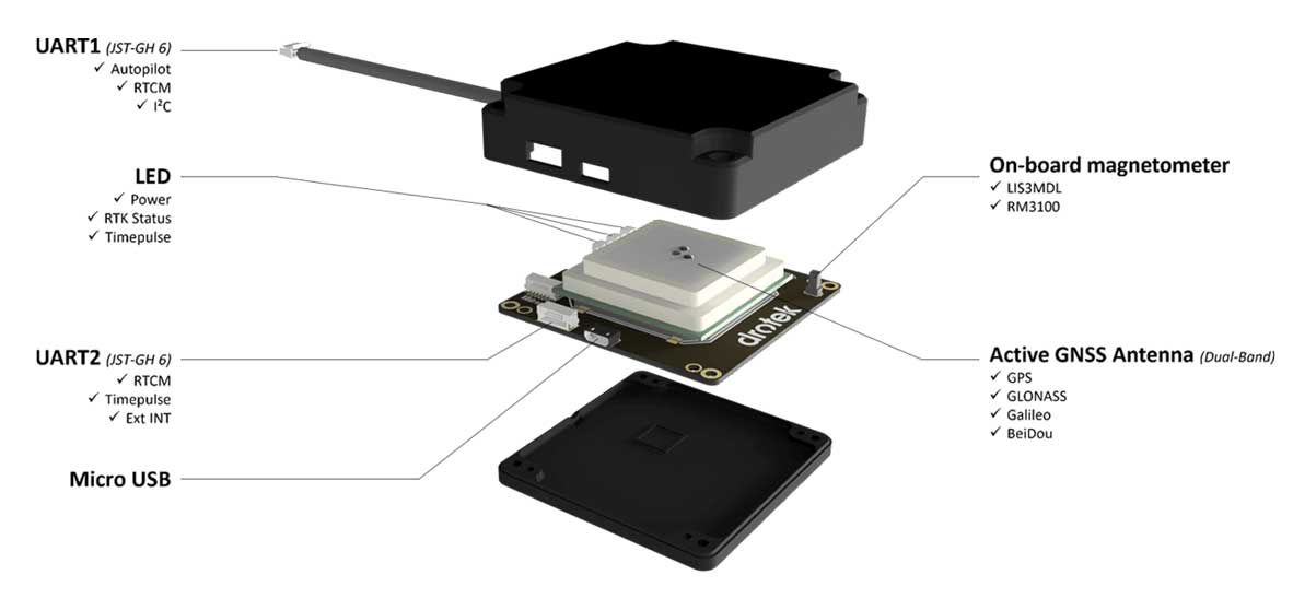
Drotek Electronics is now offering the F9P Sirius RTK GNSS Rover, which is designed to be mounted on a moving vehicle. The u-blox ZED-F9P module inside provides 1-cm position accuracy, a convergence time under 10 seconds and a navigation update rate up to 20 Hz.
The new Sirius RTK GNSS Rover F9P has a built-in active antenna patch. It receives GPS, Galileo, Beidou and GLONASS signals, providing additional accuracy. The F9 Sirius Rover is designed to fit most setup designs as well as integrate easily into a vehicle. Its six-pin JST-GH connector makes it plug-and-play with the Pixhawk Pro 3 autopilot.
Skylark is now available across the contiguous United States, enabling safe and lane-level accurate positioning.
Swift Navigation’s network-connected Skylark precise positioning service is now available throughout the United States. Full contiguous U.S. (CONUS) coverage reduces initialization times to seconds, ensuring high-accuracy, high-integrity positioning is available when customers need it.
Swift Navigation is a San Francisco-based tech firm providing centimeter-accurate GNSS positioning technology for autonomous vehicles, and the maker of the Piksi Multi and Duro GNSS receivers.
Skylark is built for autonomy at scale and delivers lane-level precision, with safety-of-life integrity, required by mass-market automotive and autonomous applications. Skylark is a scalable network delivering a continuous stream via the cloud of robust, reliable, multi-constellation, multi-frequency corrections, with the latency, security, precision and reliability required for safety and autonomy.
“Since Skylark was introduced last year, the Swift network team has been hard at work deploying infrastructure across the country,” said Rob Hranac, COO of Swift Navigation. “This extensive network helps remove hurdles in precise positioning for our customers and we look forward to partnering with those customers as we expand Skylark internationally.”
Skylark is designed to address the needs of automotive original equipment manufacturers (OEMs) by supporting ASIL-rated (Automotive Safety Integrity Level) systems and Ntrip2 (Networked Transport of RTCM via Internet Protocol) connections in cloud reference station (CRS) mode. It is state space representation (SSR) ready — an emerging industry format.
Skylark is hardware-independent, giving customers a choice in today’s rapidly improving and commodifying the GNSS sensor ecosystem. OEMs are able to benefit from the lane-level positioning Skylark delivers using a host of third-party receivers in addition to Swift’s Piksi Multi and Duro receivers.
Unlike legacy real-time-kinematic (RTK) services designed for smaller regions and precise point positioning (PPP) services that suffer from slow convergence times, Skylark is a high-performance hybrid nationwide U.S. network that delivers initialization times in seconds, better than 10 centimeters of accuracy and integrity required by the most demanding safety-of-life critical applications.
When used with Swift’s Starling positioning engine, Skylark is capable of delivering protection levels (PL) down to 1 meter and target integrity risk (TIR) down to 10-7/hour. Engineered for automotive functional safety standard ISO 26262 (ASIL B), Skylark is designed and built from the ground up to support next-generation GNSS applications, connected car, V2X and advanced driver assistance systems (ADAS).
Skylark packages GNSS precise positioning as an affordable subscription service for ease in deployment for large-scale autonomous vehicle fleets.
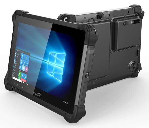
DT Research has designed a new rugged tablet with 3D imaging that is purpose-built for 3D mapping with a built-in GNSS module.
The DT301X has an Intel RealSense Depth camera that provides real-time 3D imaging combined with dual-frequency GNSS module for real-time mapping and positioning. The digital images are better than high-definition standard, and are suitable for construction building information management (BIM) graphics.
The DT301X rugged tablet is compatible with existing applications with Microsoft Windows 10 IoT Enterprise operating systems for flexible integration, and it brings together the advanced workflow for data capture, accurate positioning and data transmitting.
Key features of the DT301X
Highly durable. IP65 and MIL-STD-810G rated tablet in a slim case offers the versatility to be used in the field, office and vehicles.
Indoor/outdoor display. A high brightness 10.1-inch touchscreen offers flexible viewing in a wide range of lighting.
Wi-Fi and Bluetooth. Long-range Bluetooth for 1000-foot range and 4G LTE mobile broadband for the latest in high-speed communications.
High performance. Intel 8th-generation Core i5 or i7 processor offers high-performance while still being energy efficient.
Hot-swappable batteries. With high-capacity 60- or 90-watt hot-swappable batteries, the DT301X keeps working continuously.
In July, Volkswagen AG and Ford Motor Co. provided updates on their development alliance announced in January.
The automakers plan to collaborate on autonomous vehicles, among other programs. Together, they are investing $2.6 billion in Pittsburgh startup Argo AI, which is developing a self-driving technology platform. Ford first invested in Argo two years ago.
The investment includes the resources of VW’s Autonomous Intelligent Driving Group (AID), valued at $1.6 billion. AID will become Argo AI’s European operation.
Volkswagen and Ford hope to achieve a self-driving platform that can be scaled comparatively quickly. Argo AI’s objectives are to
build for scale.
architect the software to be production quality.
have automotive-grade sensors and computers.
fully integrate their product with OEMs and automakers.
A benefit to having the Argo AI system on more vehicles means the AI will obtain data through daily operation, enabling it to grow smarter and better.
Argo AI has successfully tested its driverless vehicles in five U.S. cities: Pittsburgh, Palo Alto, Detroit, Miami and Washington, D.C.
“Seen & Heard” is a monthly feature of GPS World magazine, traveling the world to capture interesting and unusual news stories involving the GNSS/PNT industry.
Photo: Nuro
Hey, R2, Where’s my pizza?
Domino’s pizza will start using Nuro’s R2 unmanned vehicles for delivery in Houston, Texas, later this year. Once customers have opted in, they can track the R2 vehicle via the Domino’s app and will be provided with a unique PIN code to unlock a compartment to get their pizza. Nuro is already at work in Houston delivering goods from dinner to dry cleaning.
Screenshot: BBC
Drone Attack
A BBC documentary has sent the drone industry into a tizzy. “Britain’s Next Air Disaster? Drones” begins with the December 2018 Gatwick Airport incident when two drones entering airport airspace led to a disruption of operations for three days. Dronemakers dislike the documentary’s thrust that drones are a threat to public safety and a tool for terrorists, while barely mentioning their positive contributions in fields such as search and rescue, plant inspections and agriculture.
Photo: Rawpixel.com/Shutterstock.com
NavIC Rising
The Indian Space Research Organisation is in talks with chipmakers Qualcomm and Broadcom to substitute GPS in Indian mobile phones with its own satellite system (NavIC). The Times of India noted that cellphones hold the biggest commercial potential for NavIC, with more than 650 million mobile users in India. ISRO and the Indian Air Force are also working to equip fighter jets with the navigation system, and commercial vehicles registered after April 1 are mandated to have NavIC trackers.
Photo: Monitum Pty Ltd.
Infrastructure sensors are Mthing
Internet of things (IoT) project Mthing is researching GNSS monitoring sensors to record near-real-time measurements of infrastructure construction. The 18-month project in Brisbane, Australia, aims to develop GNSS IoT sensors that will provide cost-efficient, constant and high-precision monitoring that will connect to cloud services and provide instant alerts. Mthing aims to produce low-cost sensors with broad market potential. The research team includes Queensland University of Technology, survey company Monitum, and the Innovative Manufacturing Cooperative Research Centre.