Category: Applications

  • Geocortex adds support for Arcade scripting and ArcGIS Online smart mapping

    Geocortex adds support for Arcade scripting and ArcGIS Online smart mapping

    Photo: Latitude Geographics
    Photo: Latitude Geographics

    Latitude Geographics (a VertiGIS company) has released the 4.12 version of its flagship product Geocortex Essentials to make it easier for developers of mapping applications to take advantage of Esri’s ArcGIS technology.

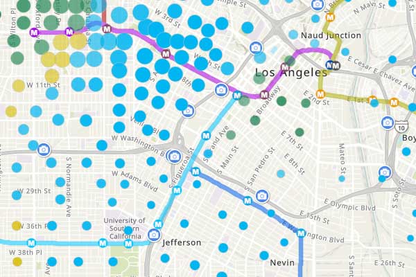
    Smart mapping. Using Esri’s smart-mapping functionality, GIS departments around the world are creating eye-catching, informative maps in ArcGIS Online. Smart mapping allows analysts to visualize and review their data in unique ways to discover trends and solve complex problems. By styling data and displaying it in a thematic map, hidden meaning can be found.

    For example, a map can now be created that uses clustering, opacity and varying color schemes to display:

    • the most prevalent level of education in a county by neighborhood,
    • the incidence of that level of education in that neighborhood, and
    • the variance from that mean level of education in that neighborhood.

    Web maps output from ArcGIS Online can now be imported into Geocortex Viewer for HTML5 (GVH) exactly as they are, meaning that all smart mapping symbology, legends and other information will be preserved and appear in GVH in the same format.

    Scripting. The Arcade expression language adds powerful scripting capabilities to the ArcGIS platform. By writing simple scripts, users can manipulate their map data on the fly in several ways.

    For example, a user could use an Arcade script to set up an identify parcel operation that also returns a summary of both the population density and communications infrastructure in the area, along with any other variables of interest. The portability of these scripts allows them to now be used within Geocortex applications.

    “The new functionality added in this release provides even stronger support for developers using the ArcGIS platform, particularly those familiar with creating smart maps in ArcGIS Online,” said Drew Millen, chief technology officer for Geocortex. “It’s now easier than ever to build a mapping application that pulls data from various sources and uses it creatively to improve decision making.”

    To learn more about the latest version of Geocortex Essentials, visit the company’s product release page.
  • Topcon releases digital farm management tools

    Topcon releases digital farm management tools

    Topcon Agriculture launched a number of digital farm management tools, including updates to the Topcon Agriculture Platform. (Photo: Topcon)
    Topcon Agriculture launched a number of digital farm management tools, including updates to the Topcon Agriculture Platform. (Photo: Topcon)

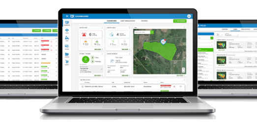
    Topcon Agriculture launched a number of digital farm management tools, including updates to its cloud-based farm management platform, Topcon Agriculture Platform (TAP). According to the company, the platform integrates state-of-the-art connectivity, cloud services and data analytics. The package is designed to suit virtually any agricultural machine, implement or technology, Topcon added.

    The Topcon Agriculture Platform features a new interface designed to increase productivity and profitability for farmers. It also has the ability to provide data on a number of variables, including yield, soil, fertility, imagery and topography.

    “We’ve worked with farmers and institutions while beta testing and are excited to roll the platform out to farmers worldwide,” said Brian Sorbe, vice president of global production solutions for Topcon. “It is the ideal solution for mixed fleets, so farmers can focus solely on decisions and action.

    “Additionally, the platform can provide seamless connectivity for sharing information so those supporting the farmers, such as dealers and agronomists, can provide real-time support, recommendations and tasks directly to the cab.”

    The company also released yield data management tools, an autosteering tool and a GNSS base receiver. The company’s Smart Cart solution is designed to provide farmers with the capability to gather highly accurate, weight-verified, geo-referenced harvest data that automatically uploads to TAP for visualizing, post processing and yield reporting, the company said.

    The other yield monitoring solution released by Topcon is the YM-2 YieldTrakk. This system services crops using conveyor-type harvesters, such as potatoes, sugar beets, grapes, onions and tomatoes.

    Topcon debuted the HiPer VR mobile base station to provide the latest GNSS tracking technology and RTK capability in a compact, rugged design to bring satellite guidance and value to any agricultural application, as well.

    Finally, the company launched its AGS-2 auto guidance system, which provides autosteering for agricultural machine types and models.

    “For increased flexibility and connectivity, the system will leverage the new TAP Cloudlynk connectivity devices for RTK corrections via cellular or radio,” Sorbe said. “A major benefit is the introduction of new TopNET Global signal options and SkyBridge, which will reduce downtime by allowing the system to continue steering due to signal coverage interruption’s when using RTK.”

    According to the company, Topcon Agriculture Platform subscriptions and cloud connectivity devices — Cloudlynk — will be available worldwide September 2019.

  • U.S. Navy to conduct GPS interference tests off Savannah

    U.S. Navy to conduct GPS interference tests off Savannah

    Photo:
    CSG4 19-03 GPS interference testing. (Image: FAA)

    A U.S. Navy exercise in the southeastern United States will involve GPS interference testing that could make aircraft navigation unreliable or unavailable on Aug. 30 and Sept. 5.

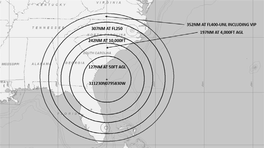
    The Federal Aviation Administration issued an advisory about the testing, which will be centered in the Atlantic off the coast of Savannah, Georgia, on the SAV VOR 139-degree radial at 84 nautical miles.

    It could affect GPS reliability — including WAAS, GBAS and ADS-B — centered at 311230N 0795830W (SAV139084):

    • within a 352-nautical-mile radius at Flight Level 400
    • within 307 nautical miles at Flight Level 250
    • within 242 nautical miles at 10,000 feet
    • within 197 nautical miles at 4,000 feet above ground level
    • within a 127-nautical-mile radius at 50 feet above ground level.

    The tests are scheduled for 1800 Zulu to 2200 Zulu on Aug. 30, and 1600 Zulu to 2000 Zulu on Sept. 5.

    The FAA advisory states that GPS interference notices to airmen may change with little or no notice, and encourages pilots to check regularly for updates. NOTAMs will be published at least 24 hours in advance of any GPS tests.

  • New Combatant commander begins organizing USSPACECOM

    New Combatant commander begins organizing USSPACECOM

    U.S. Space Command Commander General John W. “Jay” Raymond, in his first official directives, established two subordinate commands that will jointly provide support to the new Unified Combatant Command.

    Combined Force Space Component Command and Joint Task Force Space Defense will focus the planning and execution of global space operations, activities and missions into two areas:

    1. protection and defense from threats to U.S. space capabilities/forces and
    2. maintaining and growing our national security space programs, combat-relevant space capabilities, and space cadre talent to increase warfighter lethality.

    “To ensure USSPACECOM can conduct its mission decisively, I am establishing two subordinate commands with distinct and defined mission areas to ensure the command is postured to protect and defend, while also increasing joint warfighter lethality and strengthening partnerships,” Raymond said.

    “The establishment of the Department of Defense’s 11th COCOM dedicated to space operations reflects the value of space contributions to national security, the evolution of the threats to U.S. space systems, and the importance of deterring potential adversaries from challenging or attacking U.S. space systems. These subordinate commands will have a direct impact on that mission,” he said.

    JTF-SD

    The JTF-SD will be commanded by Brigadier General Thomas L. James, with a mission to conduct space superiority operations in unified action with mission partners to deter aggression, defend space capability and, when directed, defeat adversaries throughout the continuum of conflict.

    The JTF-SD will execute its protect and defend mission through various operations centers, including National Space Defense Center at Schriever Air Force Base, Colorado; Space Situational Awareness Units; and Emerging Space Defense Units.

    CFSCC

    Maj. Gen. Stephen N. Whiting. (Photo: USAF)
    Maj. Gen. Stephen N. Whiting. (Photo: USAF)

    The CFSCC will be commanded by Major General Stephen Whiting with a mission to plan, integrate, conduct and assess global space operations in order to deliver combat-relevant space capabilities to Combatant Commanders, Coalition partners, the Joint Force, and the Nation. CFSCC plans and executes space operations through four distinct and geographically dispersed operations centers, including:

    • Combined Space Operations Center at Vandenberg AFB, California;
    • Missile Warning Center at Cheyenne Mountain Air Force Station, Colorado;
    • Joint Overhead Persistent Infrared Center at Buckley AFB, Colorado; and
    • Joint Navigation Warfare Center located at Kirtland AFB, New Mexico.

    Additionally, CFSCC executes tactical control over a number of Air Force, Army and Navy space units.

    Protecting critical space assets

    “Over the past decade, our great power competitors have developed technologies that threaten our critical national assets in space,” Raymond said. “The U.S. has no desire to see a conflict in space, and we are working hard to ensure no country believes they can gain a terrestrial advantage by extending a conflict to space.

    “It’s important to understand that, like all nations, we have the inherent right of self-defense, so purposeful interference with space assets vital to our national security will be met by leveraging our multi-domain capabilities across air, land, sea, cyber and space, and all of our instruments of national power.”

  • U.S. Space Command re-established as 11th Unified Combatant Command

    U.S. Space Command re-established as 11th Unified Combatant Command

    Air Force General John W. Raymond (Photo: USAF)
    Air Force General John W. Raymond (Photo: USAF)

    In a move to enhance the United States’ space superiority capabilities, the United States Space Command (USSPACECOM) was formally re-established.

    USSPACECOM existed from 1985 to 2002 but was absorbed into U.S. Strategic Command in 2002 to make room for U.S. Northern Command and a greater focus on homeland defense.

    The Department of Defense established U.S. Space Command today as the eleventh Unified Combatant Command, with Air Force General John W. “Jay” Raymond as its congressionally confirmed commander.

    From establishment to full operational capability, General Raymond will remain dual-hatted as the commander of Air Force Space Command and U.S. Space Command. The GPS constellation is operated by Air Force Space Command’s 50th Space Wing at Schriever Air Force Base east of Colorado Springs.

    USSPACECOM will have a temporary headquarters of about 280 people at Peterson Air Force Base, Colorado.

    “Establishing USSPACECOM is a critical step that underscores the importance of the space domain and its strategic contributions to U.S. national security,” the U.S. Space Command stated in a news release. “The USSPACECOM establishment will accelerate the United States’ space capabilities to address rapidly evolving threats to U.S. space assets and the importance of deterring potential adversaries from putting critical U.S. space systems at risk.”

    “The scope, scale and complexity of today’s threat is real and it is concerning,” said Raymond during the establishment ceremony. “The establishment of a Combatant Command solely focused on the space domain demonstrates the United States’ commitment to protecting and defending its space assets against that threat.”

    Emblem of USSPACECOM
    Emblem of USSPACECOM

    The USSPACECOM mission is to deter aggression and conflict, defend U.S. and allied freedom of action, deliver space combat power for the Joint/Combined force, and develop joint warfighters to advance U.S. and allied interests in, from and through the space domain.

    The command will be postured to protect and defend, while increasing joint warfighter lethality by executing two primary missions focused on

    1. unifying and leading space capabilities for the Combined Force, and
    2. maintaining U.S. and Allied advantages in space through protection and defense.

    USSPACECOM’s global area of responsibility includes the area surrounding the earth at altitudes equal to or greater than 100 kilometers above mean sea level.

  • New NAVCEN chart shows GPS satellite locations

    New NAVCEN chart shows GPS satellite locations

    The GPS Directorate has approved a change to the Navstar GPS Control Segment to User Support Community Interfaces ICD-GPS-240 and ICD-GPS-870, reports the U.S. Coast Guard Navigation Center.

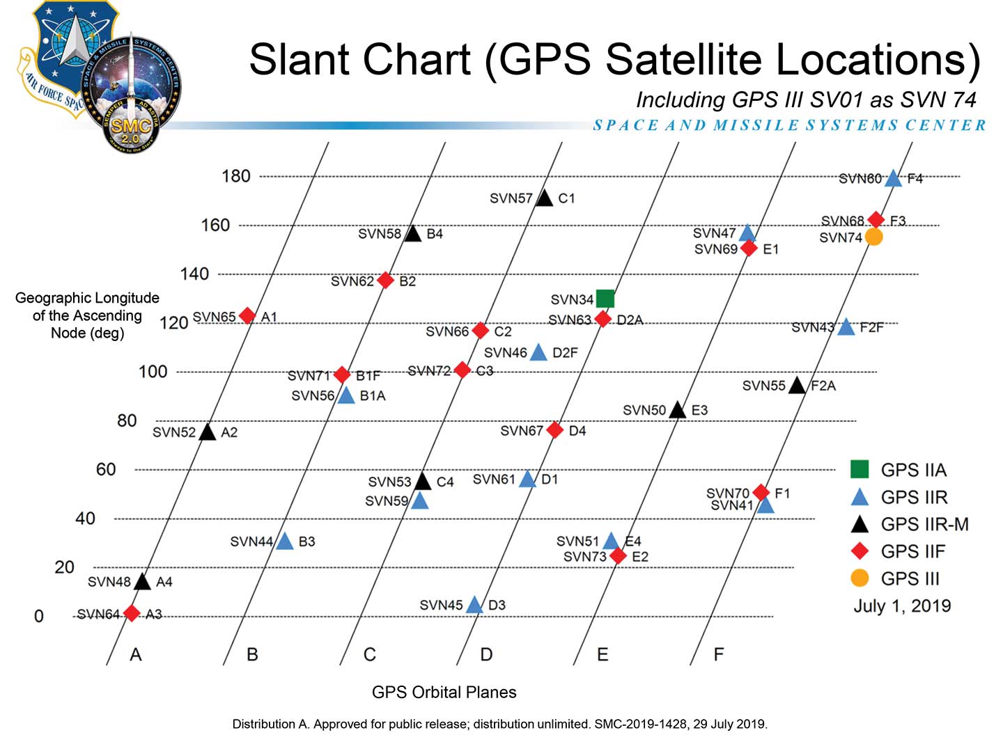
    The change removes the GPS satellite plane/slot and clock information from the Operational Advisory message. SVN/PRN, block type and NANU details will continue to be included.

    The change proposal was approved by the GPS Interface Control Working Group in December 2018.

    A depiction of the GPS constellation of satellites with slot and plane designations has been published by the U.S. Coast Guard Navigation Center as an easy-to-read graphic for use by the GPS user community.

    Chart: NAVCEN
    Chart: NAVCEN

    The chart can be found on the NAVCEN Constellation Status page and will be updated with the commissioning of new GPS satellites or upon any change in the constellation.

  • U-blox enables AddMobile’s connected construction site

    U-blox enables AddMobile’s connected construction site

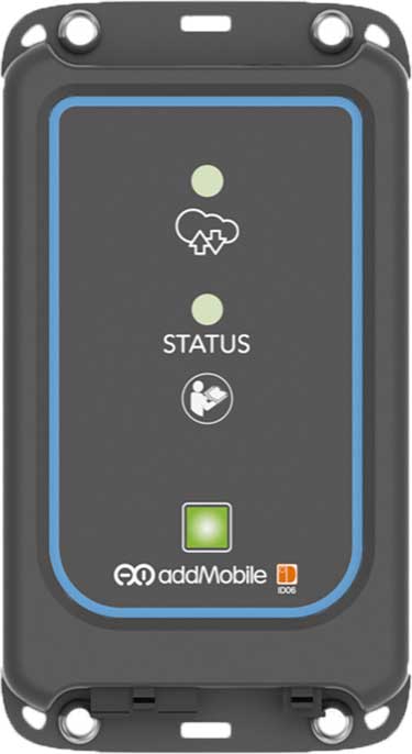
    u-blox’s Bluetooth low-energy module NINA-B1 has been chosen by AddMobile, Swedish provider of devices and services for construction site management, as the basis of its short-range equipment-tracking beacons, AddTrackers.

    Photo: AddMobile
    Photo: AddMobile

    In addition to NINA-B1, the AddMobile Toolbox features the u-blox MAX-M8 GNSS module and the u-blox GSM/GPRS cellular module SARA-G3.

    AddTrackers is among the latest enhancements to the company’s AddMobile Toolbox platform and involves adding radio beacons to any tools or equipment that need tracking.

    The AddMobile Toolbox helps site managers control mobile work orders, log fleet vehicle mileages, secure entry to work sites, register staff as they come and go, as well as handling fleet management and equipment safety.

    It uses a variety of hardware to enable these Connected Construction Site’s services, including stationary hubs and entrance control units with Bluetooth low-energy and cellular connectivity, as well as an RFID reader, and mobile hubs with GNSS, Bluetooth low energy and cellular connectivity.

    “The AddTracker beacons and hubs rely upon a combination of GNSS positioning, cellular connectivity, and Bluetooth low energy short-range radio interfaces,” said Bo Lyvall, business development manager at AddMobile. “U-blox was able to provide all three key technologies for our solutions, as well as providing great local support in the Malmö area.”

    In use, the beacons equipping tools and equipment communicate with suitably equipped smartphones or other AddMobile hardware infrastructure. When one of these devices picks up an asset’s signal, the asset’s unique ID and GNSS coordinates are sent to AddMobile’s cloud platform, which can then show managers an image of the asset and its position on a map, list the equipment’s features, and show where it is on its planned maintenance schedule.

    Trackers don’t have to be static. In one use case, a vehicle is fitted with a mobile hub that includes a GSM connection, GNSS positioning, and a Bluetooth low energy interface in the luggage area.

    Tools can be tracked on-site by static hubs, and then followed as they are put into company vans for use offsite. This means that staff scheduling offsite jobs can know the location of all their mobile personnel, and whether they have the right tools with them to undertake each task.

    The company was also attracted by the cost efficiency of u-blox’s offering, and what is already a vast installed base of interoperable Bluetooth low energy technology. In the future, the collaboration between AddMobile and u-blox may extend to the use of a longer-range variant of Bluetooth, to further reduce the cost of asset tracking on large and complex sites, and exploring the appropriate use of cellular technology in asset tracking.

  • CHC Navigation introduces new corporate website

    CHC Navigation introduces new corporate website

    Image: CHC Navigation
    Image: CHC Navigation

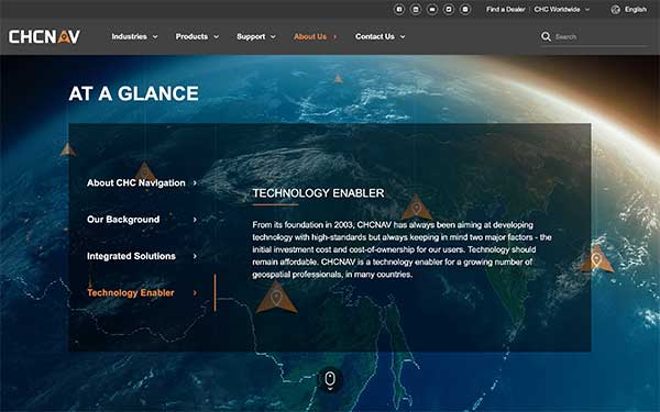
    CHC Navigation has launched a new website to convey its expanding role as a provider of geospatial and GNSS products and solutions.

    “Our new website provides a clear insight of who we are and where our ambition lies when developing, delivering and supporting high-end, professional and innovative GNSS-based solutions to our customers,” the company stated in a press release. “The website offers extensive refreshed and updated resources presenting the entire scope of CHCNAV solutions to make any surveying work more effective.”

    In commenting on the new website, George Zhao, CEO of CHC Navigation said, “We have been enjoying double-digit growth for over 16 years demonstrating the strength of CHC Navigation in the professional GNSS-based markets. Our new website brings a comprehensive vision of our technology and innovation, expanding compelling solutions and our global customer care approach.”

    Founded in 2003 and based in Shanghai, China, CHC Navigation creates GNSS navigation and positioning solutions.

  • L3Harris, Sonardyne pursue precise autonomous navigation under water

    L3Harris, Sonardyne pursue precise autonomous navigation under water

    A new case study focuses on improving the endurance and navigational precision of underwater autonomous systems.

    Sonardyne, designer and manufacturer of underwater positioning and inertial navigation, describes the challenges to increase navigation capability for subsea monitoring and inspections. Sonardyne joined the National Oceanography Centre (NOC) and L3Harris ASV on a two-year project to develop new positioning technologies to extend the limits of AUVs and UUVs.

    The project — Precise Positioning for Persistent AUVs (P3AUV) — is supported with £1.4 million  in funding through Innovate UK’s research and development competition for robotics and artificial intelligence in extreme and challenging environments.

    Sending autonomous and unmanned underwater vehicles (AUV, also known as UUVs) out on missions that will last for days or weeks, unaided by vessels or other supporting offshore infrastructure, is a major goal for the ocean science, offshore energy and defense sectors.

    Photo: Sonardyne
    Photo: Sonardyne

    Sustained Ocean Observation. The research community aims for sustained ocean observation without the need for ship support, especially in ice-covered polar areas. Long-duration navigational capability is also a key enabler for persistent covert surveillance operations in the defence sector. And emerging applications include resident seabed-based systems, deep-sea mining, aquaculture and UXO surveys for renewable installations.

    Autonomous AUVs would remove the need for a surface vessel, reduce risk to personnel, and reduce costs. Users could survey more seabed for longer and with fewer or even no people offshore.

    The team is developing ways to provide greater positioning accuracy for long-endurance operations in deep water, while also reducing power requirements. The team will also be increasing the use of autonomy to make long baseline (LBL) positioning transponder box-in faster and easier, with onboard data processing and calibration.

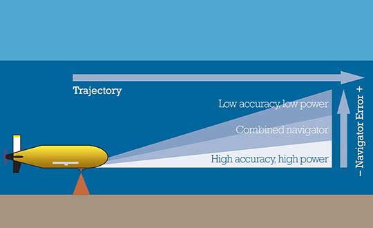
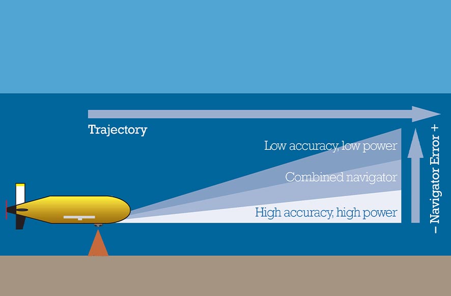
    High-power INS input. Central to this work is the AUV’s acoustic and inertial navigation system (INS). Low-power sensors have much lower navigation accuracy and often have to surface to correct positioning error with a GPS fix. The team seeks to integrate low- and high-power sensors to achieve high performance at much lower power consumption.

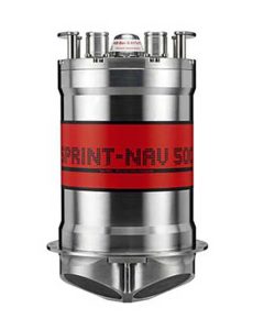
    For instance, the NOC’s Autosub Long Range (ALR) uses a low-power microelectronic mechanical system (MEMS) supported by separate Doppler velocity log (DVL) and ADCP input to calculate how far it has traveled on missions, which can be several months long. To increase the ALR’s positioning accuracy over longer distances, the team is using the Sonardyne SPRINT-Nav all-in-one subsea navigation instrument alongside MEMS technology to work towards high-precision solutions that save space and power.

    Image: Sonardyne
    Image: Sonardyne

    Accuracy during ascent and descent. The project also involves improving positioning accuracy when subsea vehicles transition through the water column. This is a notoriously difficult area for AUV deployments, because it relies on the Doppler velocity log (DVL) being able to lock on to the seafloor (bottom lock), so that vehicle XYZ velocities can be calculated, supported by pressure data.

    However, DVLs are range limited, so there is often a period where the DVL is out of range. When there are thousands of meters of water between the surface and the seabed, this can introduce significant positioning uncertainty.

    By using the acoustic Doppler current profiler (ADCP) capability in Sonardyne’s SPRINT-Nav INS instrument (looking down) and a second Syrinx DVL (looking up), the team could then build up a layer-by-layer profile of the water column velocities to be used as tracking layers.

    The objective is to reduce positioning errors significantly during both the dive and surfacing phases of an operation. Results depend on the variability of the current in any given area.

    The data collected during the descent and surfacing phases can be processed to provide a full ocean-depth current profile — collection of which is required for many offshore energy projects and can be valuable for ocean research.

    Read more about the case study here.

  • OCX supports second GPS III launch

    OCX supports second GPS III launch

    GPS OCX will maneuver satellite into final orbit over 10 days

    The U.S. Air Force used Raytheon Company’s GPS Next-Generation Operational Control System, known as GPS OCX, to support the launch of its second GPS III satellite into space. The ground system will now spend 10 days maneuvering the satellite into its final orbit, demonstrating GPS OCX’s ability to simultaneously support multiple GPS III spacecraft on-orbit throughout the checkout and calibration process.

    Raytheon’s GPS OCX has obtained the highest level of cybersecurity protections of any Department of Defense space system.

    “GPS OCX performed extremely well during the first launch and has exceeded performance requirements in the months since,” said Dave Wajsgras, president of Raytheon Intelligence, Information and Services. “The team was well-prepared for this launch, and we’re confident the system’s performance will continue to be positive.”

    GPS OCX, the enhanced ground control segment of America’s GPS system, has achieved the highest level of cybersecurity protections of any Department of Defense space system. Its open architecture design allows it to integrate advanced protections as they become available, and the system’s industry-leading cyber protections are why it will be used to support all future GPS III launches and GPS constellation operations upon operational acceptance.

    Earlier this year, the team completed final qualification testing of the system’s modernized monitor station receivers, which can receive and decrypt all GPS III military and civil signals. Global installation of the receivers starts next month and keeps the program on track for full system delivery by the program’s June 2021 contractual deadline.

    In addition to GPS OCX’s role, RGNext, a joint venture between Raytheon and General Dynamics Information Technology, provided operational launch support to ensure the safe launch of the United Launch Alliance’s Delta-IV rocket that was carrying the GPS III satellite. RGNext operates the launch range on behalf of the U.S. Air Force, providing maintenance, range safety, weather monitoring, communication and surveillance support for all launches conducted by defense, civil and commercial companies at the range.
    To access our press kit, which includes photos, videos and an animation, please visit us here. To learn more about the program’s progress and additional capabilities, visit us here.


    Featured photo: Raytheon

  • Amazon fires in Brazil can be seen from space

    Amazon fires in Brazil can be seen from space

    Wildfires in the Amazon rainforest in Brazil have hit record numbers, and satellites have been able to capture imagery of them.

    According to NASA, the Moderate Resolution Imaging Spectroradiometer on its Aqua satellite captured images of several fires burning in the states of Rondônia, Amazonas, Pará and Mato Grosso on Aug. 11 and Aug. 13.

    A satellite view of the Amazon wildfire on Aug. 13. (NASA Earth Observatory images by Lauren Dauphin, using MODIS data from NASA EOSDIS/LANCE and GIBS/Worldview and VIIRS data from NASA EOSDIS/LANCE and GIBS/Worldview, and the Suomi National Polar-orbiting Partnership.)
    A satellite view of the Amazon wildfire on Aug. 13. (NASA Earth Observatory images by Lauren Dauphin, using MODIS data from NASA EOSDIS/LANCE and GIBS/Worldview and VIIRS data from NASA EOSDIS/LANCE and GIBS/Worldview, and the Suomi National Polar-orbiting Partnership.)

    There have been 72,843 fires in Brazil this year, with more than half in the Amazon region, Brazil’s space research center, the National Institute for Space Research (INPE), said. This marks an 84% increase over the same period of 2018 and is the highest since records began in 2013, INPE added.

    Amazonas, the largest state in Brazil, recently declared a state of emergency over the forest fires, said Euro News.

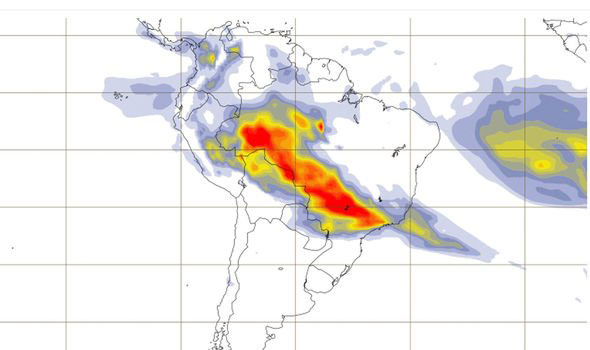
    This map shows the "Biomass burning aerosol optical depth." (Image: Copernicus' Atmosphere Monitoring Service)
    This map shows the “Biomass burning aerosol optical depth.” (Image: Copernicus’ Atmosphere Monitoring Service)

    In the Amazon region, fires are rare for much of the year because wet weather prevents them from starting and spreading. However, in July and August, activity typically increases due to the arrival of the dry season, NASA said.

  • Laser scan data improves response in active shooter simulation

    A security technology firm reduced the time needed for public-safety personnel to engage a simulated active shooter by providing the team with site floorplans created from 3D laser scan data.

    Before the exercise, the firm scanned the entire 112,000-square-foot building interior in just 2.5 hours with the GeoSLAM ZEB-HORIZON 3D mobile scanner.

    “In the role-playing scenario staged at a mega-church, the off-duty police officers reached the shooter in up to 21 percent less time using a 2D floorplan generated from the laser scans,” said Robert W. Myers, CEO of Entropy Group LLC. “However, we expect engagement times to drop considerably by leveraging the 3D scan data to create virtual reality training simulations.”

    Based in San Ramon, Calif., Entropy Group was established to save lives during active shooting incidents at schools and churches by providing law enforcement with the situational awareness information they need to reach perpetrators more quickly inside complex building spaces.

    Handheld mapping. The firm uses the GeoSLAM ZEB-HORIZON handheld mapping device to capture 3D scans of school and church interiors, including small offices, classrooms and closets. The GeoSLAM software generates highly accurate 2D floorplans for use by responders, either hardcopy or digital, to navigate the interior of the building.

    The same data set can also be used to create virtual environments where multiple officers train on computers to respond to attack scenarios in realistic, immersive 3D simulations of actual schools and churches in their jurisdictions.

    “Eventually, we plan to utilize machine learning technology that will allow individual officers of first responder teams to be dispatched to specific locations within the facility in real time to quickly reach shooter engagement locations within the buildings,” Myers said.

    The handheld ZEB-HORIZON laser scanner allows users to map interior and exterior spaces in 3D at walking speed. The lightweight device captures up to 300,000 points per second with an accuracy of 1-3 centimeters up to 100 meters from the user.

    SLAM technology ensures points are tied to local coordinate systems even in interior spaces where GPS/GNSS coverage is poor. Large multi-room buildings that might take days to scan with a stationary scanner can be mapped in a few hours with the ZEB-HORIZON.

    “Mobile laser scanning technology is the fastest and most cost-effective way to create the 2D and 3D building information tools public safety personnel need to prepare for a variety of emergency scenarios,” said Shelley Copsey, GeoSLAM CEO.

    The GeoSLAM Hub software creates a fully integrated data collection and mapping workflow, enabling ZEB-HORIZON users to process, view, merge, edit and output 2D and 3D deliverables within minutes of data capture. Outputs include 2D floorplans, CAD, as well as an integrated workflow for the creation 3D building information models (BIMs).

    Entropy Group is working directly with school districts and places of worship to provide scanning services and develop standardized procedures for the capture of 3D data inside their buildings. These reality capture data sets and derived 2D and 3D products will be provided to local public safety organizations for use in generating hardcopy and digital representations.